Sun
- Sunrise
- 6:44 AM
- Sunset
- 4:55 PM
- First light
- 6:16 AM
- Last light
- 5:23 PM
Lake · Hyde County, North Carolina
A lake in Hyde County, North Carolina.
Lake Mattamuskeet is at 0.49 feet below sea level, as of Nov 19, 2026, 7:15 AM EST. It has dropped 0.10 ft in the past 7 days.
2nd lowest of 9 North Carolina lakes today against normal for the date · See the ranking
Record low -1.24 ft (2026), record high 1.61 ft (2016) · Level history since 2012
A notification from this browser, once, when the level crosses the line (checked every hour). No account and no email. On an iPhone, add Lake by Lake to your home screen first (Share → Add to Home Screen) and open it from there. Or follow the lake in a feed reader: RSS feed.
Lake Mattamuskeet is down 0.10 ft over the last 7 days, at -0.49 ft today.
Daily values from the U.S. Geological Survey.
Lake Mattamuskeet is down 0.27 ft over the last 30 days, at -0.49 ft today.
Daily values from the U.S. Geological Survey.
Over the past 12 months, Lake Mattamuskeet ranged from -1.24 ft (Jul 6, 2026) to 0.50 ft (Aug 4, 2026), a swing of 1.7 ft. Today's level is in the lower half of that range. It is 0.12 ft higher than on this date last year.
Daily values from the U.S. Geological Survey. Why lake levels rise and fall
In the U.S. Geological Survey record, which starts in 2012, the lowest level was -1.24 ft on July 6, 2026 and the highest 1.61 ft on October 14, 2016. Today’s -0.49 ft is 0.8 ft above the record low and 2.1 ft below the record high.
Lake Mattamuskeet level history: every year since 2012, the lowest and highest years →
Solunar periods for Lake Mattamuskeet, local time. How they work
Very high · as of Nov 9, 2026
The satellite sees a strong bloom on part of the lake. Stay out of discolored water, keep pets away and check for state advisories. About 2,270,000 cells/mL at the worst spot, covering 83% of the lake.
Week of Aug 16Week of Nov 1
Each bar is one week, colored by the worst reading of that week.
From the U.S. EPA's Cyanobacteria Assessment Network (CyAN), which reads the color of lakes from the Sentinel-3 satellites; it sees open water only, not coves or the shoreline. Blooms can be patchy: what you see on the water matters more. Swimming closures and health advisories come from North Carolina health and environment agencies. How to read it
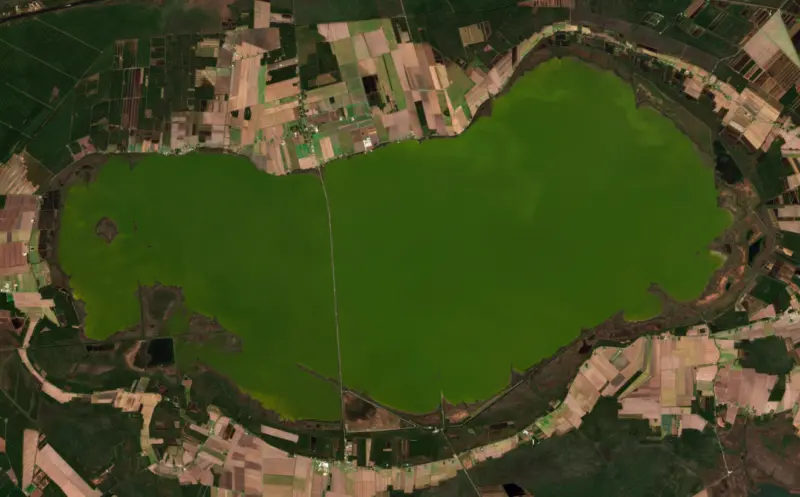
The last 12 satellite passes
83°F · Jul 3063°F · Nov 10
20°F cooler than on Jul 30, 2026.
Estimated from MODIS Aqua (NASA) passes on clear days: the top layer of the water, a few degrees either way. Coves and the shallows can be warmer.
Lake Mattamuskeet water temperature: trend, swimming and the fish →
On or near the shore of Lake Mattamuskeet: 1 boat ramp and 2 campgrounds. The lake has about 88 miles of shoreline, counting its islands.
Tap an icon for details; use two fingers (or Ctrl + scroll) to move the map. Tap a dot for details. Map and lake outline © OpenStreetMap contributors. Places from OpenStreetMap, Overture Maps and Recreation.gov. Not for navigation.
No aquatic invasive species are on record for Lake Mattamuskeet in the USGS database. Keep it that way: clean, drain and dry your boat between lakes.
North Carolina: North Carolina has no clean-drain-dry law for boaters. The Wildlife Resources Commission urges you to clean off plants, animals and mud, drain all water, dry your gear, and never move fish or plants from one water to another. State rules
Records: USGS Nonindigenous Aquatic Species database. A species not listed may still be present.
Species with open-licensed records inside Lake Mattamuskeet's outline, from GBIF.org (surveys, museum collections and angler reports). A record shows a fish was found here, not how many there are now.
Shallow, protected flats in spring; docks, grass and deep edges in summer heat.
Channel edges and river arms; best after dark in summer, and after a rain.
Schools over open flats in summer; inlets and shallow shorelines in spring.
Shallow, muddy bays and flooded grass in spring; mud flats and inflows in summer.
Near the surface over weedy shallows and backwaters on calm, warm days.
Water temperature sets off each spawn; the bars show the usual months at this latitude and elevation, and move with a warm or cold spring. The water is about 52°F now.
Lake Mattamuskeet is the largest natural lake in North Carolina, a broad, shallow sheet of water in Hyde County on the Albemarle-Pamlico Peninsula, between Swan Quarter and Engelhard. The whole lake belongs to Mattamuskeet National Wildlife Refuge, and it is known above all for the tundra swans, geese and ducks that crowd onto it every winter.
No one knows for certain how the lake formed. One idea holds that fires burned deep into the peat soil and left a basin that filled with water. Another blames a shower of meteors striking the coastal plain, and a third links it to the Carolina bays of the coastal plain. Bald cypress trees stand out in the water, and the lake averages only about 2 feet deep, with its deepest spots around 5 feet. Left alone, it was fed only by rain, runoff and groundwater. The name comes from the Algonquian-speaking people of the region. Europeans first saw the lake in 1585, on one of Sir Walter Raleigh's early voyages, and after the Tuscarora War a reservation was set up around it in 1715 for the Core, Cotechny and Mattamuskeet peoples, though white settlers kept pressing onto their land.
Because the lake was so shallow, people kept trying to drain it. In 1837, while the State Literary Board owned it, enslaved laborers dug a 7-mile canal toward Pamlico Sound that shrank the lake. In 1909 the legislature created a drainage district, and the Southern Land Reclamation Company bought 48,830 acres from the state at $2 an acre. Its plan was modeled on Dutch land reclamation, so the village laid out beside the pumps in 1915 was named New Holland. The pumping plant, built in 1915 and 1916, was the largest in the world at the time, and the lake bed was pumped dry and farmed for stretches. Money trouble shut the operation in 1923. New investors led by the New York philanthropist August Heckscher started again in 1925 and farmed the bottom for about six years, until heavy rains and pests ended the effort in 1932. More than a million dollars had gone into it.
In 1934 the federal government bought the lake and made it a refuge for migratory birds. Men from the Civilian Conservation Corps turned the old pumping plant into Mattamuskeet Lodge, adding guest rooms and building a spiral staircase inside the smokestack to make an observation tower. From 1937 the lodge served hunters as a hotel and restaurant, until it closed in 1974 as goose numbers fell. It was listed on the National Register of Historic Places in 1980, and in 2007 it passed to the North Carolina Wildlife Resources Commission. The refuge also manages more than 3,000 acres of marsh impoundments on the south and east sides of the lake to grow natural food for waterfowl.
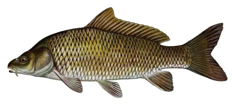
More than 100,000 waterfowl, among them tundra swans, Canada and snow geese and 18 species of ducks, spend the winter on the refuge, which sits on the Atlantic Flyway. The best views come from the Highway 94 causeway, which crosses the lake and has an observation deck, and from the Wildlife Drive near refuge headquarters. Each December an open house lets visitors into parts of the refuge that are otherwise closed in winter. Boating is banned from November 1 through the end of February, and swimming, jet skis, airboats and sailing are not allowed at any time. In the warmer months anglers fish the lake and canals for largemouth bass, striped bass, catfish and crappie, and catching blue crabs at the water control structures is a local favorite. The lake has struggled since the early 1990s. Invasive common carp and poor water quality wiped out the underwater plants that waterfowl once fed on, and federal and state agencies have been working to bring them back.
Written by Lake by Lake from U.S. Fish and Wildlife Service, North Carolina Department of Natural and Cultural Resources (Mattamuskeet (B-42), Mattamuskeet National Wildlife Refuge (B-58)) and Wikipedia. Checked November 2026.
Activities listed by the Fish and Wildlife Service: Scenic drives · Boating · Ranger programs · Fishing · Hiking · Hunting · Wildlife viewing · Photography · Birding
Where the level comes from: LAKE MATTAMUSKEET E OF NC HWY 94 NR FAIRFIELD, NC (U.S. Geological Survey).
Lake Mattamuskeet is at 0.49 feet below sea level, as of Nov 19, 2026, 7:15 AM EST. It has dropped 0.10 ft in the past 7 days.
Today's level is 0.50 ft below the median for this date (0.01 ft), from the gauge’s long-term daily record.
-1.24 ft, on July 6, 2026, in the U.S. Geological Survey record, which starts in 2012. Today the lake is 0.8 ft above that.
1.61 ft, on October 14, 2016, in the U.S. Geological Survey record since 2012.
Lake Mattamuskeet has 1 boat ramp on our map. Low water can close ramps, so check today's level above and the operator before you go.
Yes. There are 2 campgrounds and RV parks within about a mile of the shore, such as Osprey Nest Campground, Carawans Cabins and Campground.
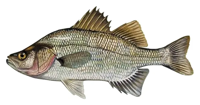
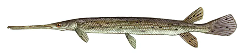
Game fish recorded in Lake Mattamuskeet include channel catfish, largemouth bass, white perch, common carp, longnose gar, warmouth. In all, 13 fish species have open records inside the lake on GBIF.
The water at Lake Mattamuskeet is 52°F, measured 1 hr ago by the USGS sensor in the lake. Surface temperature changes through the day and with depth.
Anglers 16 and older need a North Carolina fishing license, sold online by the North Carolina Wildlife Resources Commission. Free fishing days: July 4. Size and bag limits can be set lake by lake: check the current regulations.
Lake Mattamuskeet averages about 9 ft deep. Depth changes with the lake level.
In summer a white Secchi disk lowered into Lake Mattamuskeet stays visible to about 0.8 ft (the median of 155 readings, 2023–2024, by University of North Carolina at Chapel Hill Institute of Marine Sciences and North Carolina Dept of Environmental Quality NCDEQ-DWR WQX): murky water. With the algae measured too (chlorophyll about 88 µg/L), that makes it hypereutrophic: very rich in nutrients, prone to algae. Clarity drops after storms and during algae blooms.
Fish and Wildlife Service lists scenic drives, boating, ranger programs, fishing, hiking, hunting, wildlife viewing and photography at Mattamuskeet National Wildlife Refuge.
EPA's CyAN satellite rated cyanobacteria in Lake Mattamuskeet very high on November 9. The satellite sees open water only; blooms can be patchy, so avoid water that looks like spilled paint or pea soup and keep dogs out of scum. Swimming advisories come from North Carolina health and environment agencies.
From the U.S. Geological Survey (LAKE MATTAMUSKEET E OF NC HWY 94 NR FAIRFIELD, NC). Lake by Lake checks it every hour; the agency's own figure is always the reference, and provisional readings can be revised.
Lake levels are refreshed every hour. Texas and California reservoirs report once a day; most USGS and NOAA gauges report every 15 to 60 minutes.
Cookies for analytics With your OK we use Google Analytics and Microsoft Clarity to count visits and see how the site is used, so we can make it better. No advertising cookies. Privacy policy