Sun
- Sunrise
- 7:00 AM
- Sunset
- 5:17 PM
- First light
- 6:33 AM
- Last light
- 5:43 PM
Reservoir · Atoka County, Oklahoma
A reservoir on Mcgee Creek in Atoka County, Oklahoma, held back by Mcgee Creek Dam since 1968. Also called McGee Lake and Mcgee Creek Reservoir.
McGee Creek Lake is at 569.56 feet above sea level — 7.54 ft below top of conservation pool, as of Nov 19, 2026, 1:15 AM CST. It has dropped 0.51 ft in the past 7 days.
5th lowest of 37 Oklahoma lakes today against full pool · See the ranking
Record low 566.51 ft (2017), record high 599.04 ft (2015) · Level history since 2014
A notification from this browser, once, when the level crosses the line (checked every hour). No account and no email. On an iPhone, add Lake by Lake to your home screen first (Share → Add to Home Screen) and open it from there. Or follow the lake in a feed reader: RSS feed.
McGee Creek Lake is down 0.51 ft over the last 7 days, at 569.56 ft today.
Daily values from the NOAA National Water Prediction Service.
McGee Creek Lake is down 1.88 ft over the last 30 days, at 569.56 ft today.
Daily values from the NOAA National Water Prediction Service.
Over the past 12 months, McGee Creek Lake ranged from 568.55 ft (Feb 13, 2026) to 580.63 ft (Jun 26, 2026), a swing of 12.1 ft. Today's level is near the bottom of that range. It is 3.62 ft lower than on this date last year.
Daily values from the NOAA National Water Prediction Service. Why lake levels rise and fall
In the U.S. Army Corps of Engineers record, which starts in 2014, the lowest level was 566.51 ft on April 16, 2017 and the highest 599.04 ft on May 21, 2015. Today’s 569.56 ft is 3.0 ft above the record low and 29.5 ft below the record high.
McGee Creek Lake level history: every year since 2014, the lowest and highest years →
Solunar periods for McGee Creek Lake, local time. How they work
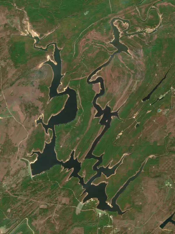
Surface water temperature
73°F on Oct 22, 2026
90°F · Jul 2773°F · Oct 22
17°F cooler than on Jul 27, 2026.
Estimated from Landsat 8/9 (USGS) passes on clear days: the top layer of the water, a few degrees either way. Coves and the shallows can be warmer.
McGee Creek Lake water temperature: trend, swimming and the fish →
On or near the shore of McGee Creek Lake: 3 boat ramps. The lake has about 71 miles of shoreline, counting its islands.
Tap an icon for details; use two fingers (or Ctrl + scroll) to move the map. Tap a dot for details. Map and lake outline © OpenStreetMap contributors. Places from OpenStreetMap, Overture Maps and Recreation.gov. Not for navigation.
What you’ll find on the shore
← AllBoating 3
No aquatic invasive species are on record for McGee Creek Lake in the USGS database. Keep it that way: clean, drain and dry your boat between lakes.
Oklahoma: Before launching, remove all aquatic plants and zebra or quagga mussels from your boat, trailer and gear (state law); moving aquatic plants between waters is also illegal. Draining, and drying for five days if you can't hot-wash, are recommended but not required. State rules
Records: USGS Nonindigenous Aquatic Species database. A species not listed may still be present.
McGee Creek Lake is a reservoir in Atoka County, Oklahoma. Lake by Lake tracks its level from the NOAA National Water Prediction Service and compares it with full pool and the readings of the past year.
McGee Creek Dam and Reservoir project includes water conveyance facilities, public recreation facilities, a wildlife management area, and a natural scenic recreation area. The McGee Creek Project provides a municipal and industrial water supply to Oklahoma City and southeast Oklahoma. Three areas provide opportunities for birding. Some of the species to be seen are Wild Turkey, Pileasted Woodpecker, Brown-headed Nuthatch, and Pine Warbler.
Activities listed by the Bureau of Reclamation: Biking · Boating · Camping · Fishing · Hiking · Horseback riding · Hunting · Picnicking · Water sports · Wildlife viewing
Mcgee Creek Dam is an earthfill dam 161 feet high and 1,998 feet long on Mcgee Creek, completed in 1968. It belongs to the Bureau of Reclamation. At its normal level the reservoir holds 113,350 acre-ft, drained from 182 square miles of land.
From the National Inventory of Dams (U.S. Army Corps of Engineers), NID ID OK22194. Lake or reservoir: what’s the difference?
Where the level comes from: McGee Creek at McGee Creek Lake (NOAA National Water Prediction Service, used on this page) and Mcgee Creek Reservoir and Dam (Bureau of Reclamation (RISE)).
| Lake | Miles | Level (ft) | vs full | 7 days |
|---|---|---|---|---|
| Lake Atoka Reservoir Live reading | 15 | 584.69 | — | −0.16 |
| Hugo Lake Slightly below full | 35 | 400.09 | −4.41 | −0.12 |
| Sardis Lake At or near full pool | 37 | 597.02 | −1.98 | −0.17 |
| Pat Mayse Lake Slightly below full | 37 | 448.21 | −2.79 | +0.04 |
| Bois D'Arc Lake Slightly below full | 42 | 530.62 | −3.38 | −0.19 |
| Lake Crook Slightly below full | 44 | 474.26 | −1.74 | −0.07 |
Compare McGee Creek Lake with Lake Atoka Reservoir, Hugo Lake, Sardis Lake or Pat Mayse Lake: size, level, ramps and fish side by side.
McGee Creek Lake is also known as McGee Lake and Mcgee Creek Reservoir.
McGee Creek Lake is at 569.56 feet above sea level — 7.54 ft below top of conservation pool, as of Nov 19, 2026, 1:15 AM CST. It has dropped 0.51 ft in the past 7 days.
McGee Creek Lake's top of conservation pool is 577.10 ft, according to U.S. Army Corps of Engineers. Today the lake is 7.54 ft below that mark.
Today's level is 5.61 ft below the median for this date (575.17 ft), from the gauge’s long-term daily record.
566.51 ft, on April 16, 2017, in the U.S. Army Corps of Engineers record, which starts in 2014. Today the lake is 3.0 ft above that.
599.04 ft, on May 21, 2015, in the U.S. Army Corps of Engineers record since 2014. That is 21.9 ft above top of conservation pool.
McGee Creek Lake has 3 boat ramps on our map. Low water can close ramps, so check today's level above and the operator before you go.
Anglers 18 and older need an Oklahoma fishing license, sold online by the Oklahoma Department of Wildlife Conservation. Free fishing days: First weekend in June. Size and bag limits can be set lake by lake: check the current regulations.
McGee Creek Lake averages about 35 ft deep. Depth changes with the lake level.
Bureau of Reclamation lists biking, boating, camping, fishing, hiking, horseback riding, hunting and picnicking at McGee Creek Reservoir.
McGee Creek Lake is held back by Mcgee Creek Dam, completed in 1968 and 161 ft high, according to the National Inventory of Dams.
From the NOAA National Water Prediction Service (McGee Creek at McGee Creek Lake). Lake by Lake checks it every hour; the agency's own figure is always the reference, and provisional readings can be revised.
Lake levels are refreshed every hour. Texas and California reservoirs report once a day; most USGS and NOAA gauges report every 15 to 60 minutes.
Cookies for analytics With your OK we use Google Analytics and Microsoft Clarity to count visits and see how the site is used, so we can make it better. No advertising cookies. Privacy policy