Sun
- Sunrise
- 7:06 AM
- Sunset
- 5:14 PM
- First light
- 6:38 AM
- Last light
- 5:42 PM
Reservoir · Utah
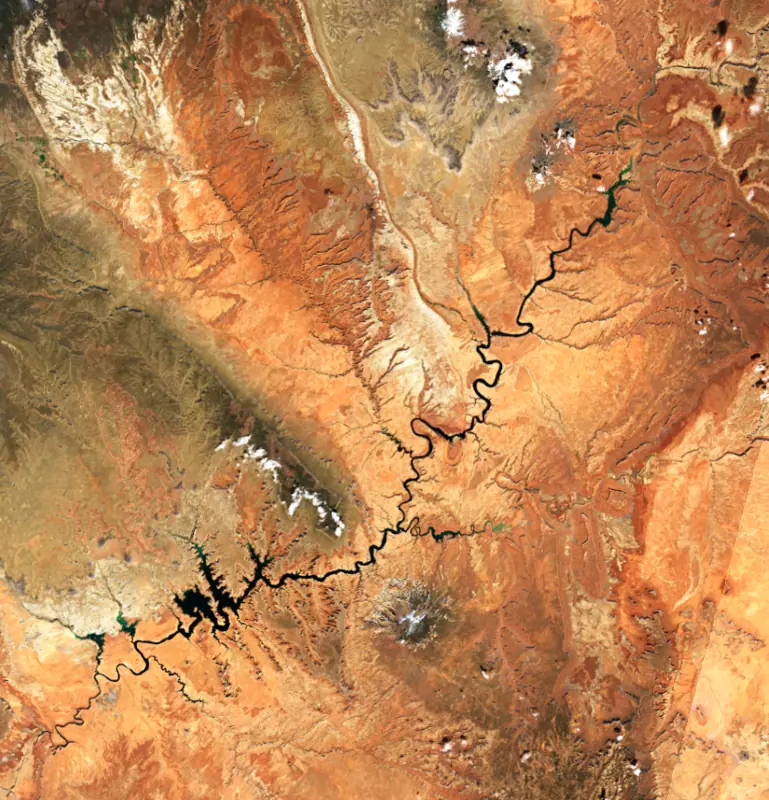
A reservoir on the Colorado River in Arizona and Utah, held back by Glen Canyon Dam since 1963.

Lake Powell is at 3,540.00 feet above sea level — 160.00 ft below full pool, as of Nov 17, 2026, 7:45 PM MST. It has risen 1.00 ft in the past 7 days.
Lowest of 24 Utah lakes today against full pool · See the ranking
Record low 3,516.40 ft (2026), record high 3,621.40 ft (2019) · Level history since 2019
Which boat ramps are usable at today’s level →
A notification from this browser, once, when the level crosses the line (checked every hour). No account and no email. On an iPhone, add Lake by Lake to your home screen first (Share → Add to Home Screen) and open it from there. Or follow the lake in a feed reader: RSS feed.
Lake Powell is up 19.80 ft over the last 30 days, at 3,540.00 ft today.
Daily values from the U.S. Geological Survey.
Over the past 12 months, Lake Powell ranged from 3,516.40 ft (Sep 16, 2026) to 3,543.90 ft (Nov 18, 2025), a swing of 27.5 ft. Today's level is near the top of that range. It is 3.90 ft lower than on this date last year.
Daily values from the U.S. Geological Survey. Why lake levels rise and fall
In the U.S. Geological Survey record, which starts in 2019, the lowest level was 3,516.40 ft on September 16, 2026 and the highest 3,621.40 ft on August 5, 2019. Today’s 3,540.00 ft is 23.6 ft above the record low and 81.4 ft below the record high.
Lake Powell level history: every year since 2019, the lowest and highest years →
Solunar periods for Lake Powell, local time. How they work
Low · as of Nov 9, 2026
Some cyanobacteria at the surface, under 100,000 cells/mL. About 20,700 cells/mL at the worst spot, covering less than 1% of the lake.
Week of Aug 16Week of Nov 1
Each bar is one week, colored by the worst reading of that week.
From the U.S. EPA's Cyanobacteria Assessment Network (CyAN), which reads the color of lakes from the Sentinel-3 satellites; it sees open water only, not coves or the shoreline. Blooms can be patchy: what you see on the water matters more. Swimming closures and health advisories come from Utah health and environment agencies. How to read it
Surface water temperature
60°F on Nov 14, 2026
92°F · Jul 2460°F · Nov 14
32°F cooler than on Jul 24, 2026.
Estimated from Landsat 8/9 (USGS) passes on clear days: the top layer of the water, a few degrees either way. Coves and the shallows can be warmer.
Lake Powell water temperature: trend, swimming and the fish →
On or near the shore of Lake Powell: 20 boat ramps, 10 marinas, 1 rental outfit, 14 campgrounds, 3 beaches and 4 trails. The lake has about 1,477 miles of shoreline, counting its islands.
Tap an icon for details; use two fingers (or Ctrl + scroll) to move the map. Tap a dot for details. Map and lake outline © OpenStreetMap contributors. Places from OpenStreetMap, Overture Maps and Recreation.gov. Not for navigation.
What you’ll find on the shore
← AllBoating 30
Which boat ramps are usable at today’s level →
← AllRentals & tours 1
← AllBeaches 3
← AllCamping 14
← AllLodging 6
← AllTrails 4
← AllParks 3
← AllDining 7
Quagga mussels have been found in Lake Powell. They clog intakes and engines and spread on boats and trailers: clean, drain and dry everything before you go to another lake.
Arizona: When leaving waters listed as having invasive species (such as Lakes Mead, Mohave, Havasu and Powell and the lower Colorado River) you must remove plants, mud and animals, drain all water and keep drain plugs out while transporting. Boats kept on a listed water for 6 or more days must get a free professional decontamination before they are moved. State rules
Utah: Every boater, paddlers included, must take the Mussel-Aware Boater course each year, and motorboats need an annual AIS decal; pull drain plugs and sea strainers when leaving any water and while trailering. Boats leaving Lake Powell must be inspected, then professionally decontaminated or dried 7 to 30 days before launching elsewhere. Required: Mussel-Aware Boater course certificate; AIS decal (motorboats) (Course free; AIS decal $20 a year for Utah motorboats, $25 for nonresident motorboats). State rules
Records: USGS Nonindigenous Aquatic Species database. A species not listed may still be present.
Species with open-licensed records inside Lake Powell's outline, from GBIF.org (surveys, museum collections and angler reports). A record shows a fish was found here, not how many there are now.
Shallow, protected flats in spring; docks, grass and deep edges in summer heat.
Brush piles, docks and bridge pilings; shallow for a few weeks in spring.
Channel edges and river arms; best after dark in summer, and after a rain.
Rocky points, gravel and current breaks; deeper rock piles in summer.
Rocky shorelines at night after ice-out; deep weed edges and humps in summer.
Water temperature sets off each spawn; the bars show the usual months at this latitude and elevation, and move with a warm or cold spring. The water is about 60°F now.
Lake Powell is the reservoir behind Glen Canyon Dam on the Colorado River, a long, branching lake that starts at Page, Arizona, and reaches deep into the canyon country of southern Utah. It lies inside Glen Canyon National Recreation Area, run by the National Park Service, and is known for houseboat trips into narrow side canyons and for the boat ride to Rainbow Bridge.
Congress authorized the Colorado River Storage Project on April 11, 1956, and Glen Canyon became its main storage unit. That October 15, President Dwight D. Eisenhower set off the first blast by signal from Washington. In 1957 the Bureau of Reclamation put up a camp for workers and their families and named it for Reclamation Commissioner John C. Page. The camp became the town of Page, incorporated in 1975. The diversion tunnels closed on March 13, 1963, and the river began to back up. The last bucket of concrete went in that September. Eighteen workers died building the dam. The first power came in 1964, and Lady Bird Johnson dedicated the dam and powerplant in 1966. Filling took until June 22, 1980, and along the way the sandstone walls soaked up about 13.4 million acre-feet of water. The lake is named for John Wesley Powell, who led the first expedition down the Colorado through the Grand Canyon in 1869.
Travel on the lake is by boat. Near the dam are Wahweap Marina, about 5.5 miles away along Lakeshore Drive, and Antelope Point, about 5 miles uplake on the main channel. Far uplake, some 95 miles from the dam, Bullfrog and Halls Crossing face each other across the water, and the Charles Hall Ferry carries cars between them when it is in service. The Colorado, San Juan and Escalante rivers all feed the lake.
The best-known stop is Rainbow Bridge. President William Howard Taft made it a national monument on May 30, 1910. The arch rises 290 feet and spans 275 feet. Native peoples of the region have long held it sacred, and the park consults on its care with affiliated tribes that include the Navajo, Hopi, Paiute and Ute nations. Before the dam, a visit meant days on the river and a 7-mile hike. Once the lake rose, thousands of people a year began arriving by boat.
Before the dam, the river held native suckers and chubs suited to silty water. The lake's game fish were all brought in: striped, smallmouth and largemouth bass, walleye, crappie, bluegill and catfish. Stripers and walleye carry no bag limit. Utah and Arizona jointly advise against eating too much striped bass from the southern lake, from about mile 43 down to the dam, because of mercury. A license from either state covers the whole lake. Endangered natives such as the humpback chub, bonytail, Colorado pikeminnow and razorback sucker must be released at once.
Below the dam, the roughly 15 miles of river down to Lees Ferry is a different world. The dam made the water cooler, and rainbow trout were introduced there in 1964. The stretch is regarded as a Blue Ribbon trout fishery. Stocking stopped in 1998 once the fish were reproducing on their own, though numbers have boomed and crashed several times since.
The lake usually rises from May into July as spring runoff comes down the rivers. Long drought in the Colorado basin has pulled it far below full. It set a record low in April 2023, then broke that record on August 15, 2026, after a record-dry winter. In low years ramps close or move and marinas shift to deeper water, so it pays to check launch conditions before towing a boat. Quagga mussels have been confirmed both above and below the dam, and the park asks every boater and angler to clean, drain and dry boats and gear after leaving the water.
Written by Lake by Lake from Bureau of Reclamation, Upper Colorado Basin Region, National Park Service, Rainbow Bridge National Monument, National Park Service, Glen Canyon National Recreation Area (Lake Powell Marinas, Fishing), U.S. Geological Survey, Southwest Biological Science Center and PBS NewsHour. Checked November 2026.
Activities listed by the Bureau of Reclamation: Scenic drives · Biking · Boating · Historic sites · Camping · Ranger programs · Fishing · Hiking · Off-road vehicles · Picnicking · Visitor center · Water sports
Glen Canyon Dam is a concrete dam 710 feet high and 1,560 feet long on the Colorado River, completed in 1963. It belongs to the Bureau of Reclamation and is run for hydropower, irrigation and recreation. Water reaches it from 107,417 square miles of land.
From the National Inventory of Dams (U.S. Army Corps of Engineers), NID ID AZ10307. Lake or reservoir: what’s the difference?
Where the level comes from: LAKE POWELL AT GLEN CANYON DAM, AZ (U.S. Geological Survey, used on this page), Lake Powell (Bureau of Reclamation) and Lake Powell Glen Canyon Dam and Powerplant (Bureau of Reclamation (RISE)).
Lake Powell is at 3,540.00 feet above sea level — 160.00 ft below full pool, as of Nov 17, 2026, 7:45 PM MST. It has risen 1.00 ft in the past 7 days.
Lake Powell's full pool is 3,700.00 ft, according to Bureau of Reclamation. Today the lake is 160.00 ft below that mark.
Today's level is 31.80 ft below the median for this date (3,571.80 ft), from the gauge’s long-term daily record.
3,516.40 ft, on September 16, 2026, in the U.S. Geological Survey record, which starts in 2019. Today the lake is 23.6 ft above that.
3,621.40 ft, on August 5, 2019, in the U.S. Geological Survey record since 2019.
Lake Powell has 20 boat ramps on our map, including Antelope Point Business Ramp, Antelope Point Public Launch Ramp, Boat ramp near Antelope Point Marina, and 10 marinas. Low water can close ramps, so check today's level above and the operator before you go.
Yes. There are 14 campgrounds and RV parks within about a mile of the shore, such as Lone Rock Beach Primitive Camping, Wahweap Campground, Farley Canyon Primitive Camping Area.
Game fish recorded in Lake Powell include largemouth bass, black crappie, walleye, striped bass, smallmouth bass, channel catfish. In all, 28 fish species have open records inside the lake on GBIF.
The surface of Lake Powell was about 60°F on November 14, estimated from a satellite pass on a clear day. It is the top layer of the water, a few degrees either way; coves and shallows run warmer in the sun.
Lake Powell lies in Arizona and Utah: the license of the state where you fish applies. Anglers 10 and older need an Arizona fishing license, sold online by the Arizona Game and Fish Department. Free fishing days: Usually the first Saturday of National Fishing and Boating Week (June). Anglers 12 and older need a Utah fishing license, sold online by the Utah Division of Wildlife Resources. Free fishing days: Free Fishing Day, one Saturday in June (2026: June 6). Size and bag limits can be set lake by lake: check the current regulations.
Lake Powell is about 492 ft deep at its deepest point, usually near the dam. Depth changes with the lake level.
In summer a white Secchi disk lowered into Lake Powell stays visible to about 13.5 ft (the median of 65 readings, 2017–2025, by Utah Department Of Environmental Quality): very clear water. Silt after rain lowers the reading as much as algae do. Clarity drops after storms and during algae blooms.
Yes: reservoir survey report with contour maps from the U.S. Bureau of Reclamation (1986). It is linked in the lake facts on this page. Depths on a map are measured at a reference level: subtract how far the lake is below it today.
Bureau of Reclamation lists scenic drives, biking, boating, historic sites, camping, ranger programs, fishing and hiking at Lake Powell.
EPA's CyAN satellite rated cyanobacteria in Lake Powell low on November 9. The satellite sees open water only; blooms can be patchy, so avoid water that looks like spilled paint or pea soup and keep dogs out of scum. Swimming advisories come from Utah health and environment agencies.
Yes. 4 trails run along or near the shore, including ADT - Utah - R - Seg 3, Rainbow Bridge Trail (3.1 mi) and Reflection Canyon Trail (7.6 mi), according to OpenStreetMap.
Lake Powell is held back by Glen Canyon Dam, completed in 1963 and 710 ft high, according to the National Inventory of Dams.
From the U.S. Geological Survey (LAKE POWELL AT GLEN CANYON DAM, AZ). Lake by Lake checks it every hour; the agency's own figure is always the reference, and provisional readings can be revised.
Lake levels are refreshed every hour. Texas and California reservoirs report once a day; most USGS and NOAA gauges report every 15 to 60 minutes.




