Sun
- Sunrise
- 7:13 AM
- Sunset
- 5:30 PM
- First light
- 6:46 AM
- Last light
- 5:56 PM
Reservoir · Arizona
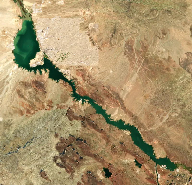
A reservoir on the Colorado River in Arizona and California, held back by Parker Dam since 1938.

Lake Havasu is at 446.94 feet above sea level — 3.06 ft below normal maximum, as of Nov 17, 2026. It has dropped 0.92 ft in the past 7 days.
2nd fullest of 6 Arizona lakes today against full pool · See the ranking
Record low 440.04 ft (1940), record high 451.00 ft (1943) · Level history since 1939
A notification from this browser, once, when the level crosses the line (checked every hour). No account and no email. On an iPhone, add Lake by Lake to your home screen first (Share → Add to Home Screen) and open it from there. Or follow the lake in a feed reader: RSS feed.
Lake Havasu is down 1.31 ft over the last 30 days, at 446.94 ft today.
Daily values from the Bureau of Reclamation.
Over the past 12 months, Lake Havasu ranged from 446.23 ft (Dec 15, 2025) to 449.49 ft (Nov 26, 2025), a swing of 3.3 ft. Today's level is in the lower half of that range. It is 1.18 ft lower than on this date last year.
Daily values from the Bureau of Reclamation. Why lake levels rise and fall
In the Bureau of Reclamation record, which starts in 1939, the lowest level was 440.04 ft on October 28, 1940 and the highest 451.00 ft on September 18, 1943. Today’s 446.94 ft is 6.9 ft above the record low and 4.1 ft below the record high.
Lake Havasu level history: every year since 1939, the lowest and highest years →
Solunar periods for Lake Havasu, local time. How they work
Not detected · as of Nov 9, 2026
The satellite found no cyanobacteria at the surface.
Week of Aug 9Week of Nov 1
Each bar is one week, colored by the worst reading of that week.
From the U.S. EPA's Cyanobacteria Assessment Network (CyAN), which reads the color of lakes from the Sentinel-3 satellites; it sees open water only, not coves or the shoreline. Blooms can be patchy: what you see on the water matters more. Swimming closures and health advisories come from Arizona health and environment agencies. How to read it
Surface water temperature
69°F on Nov 12, 2026
93°F · Jul 2369°F · Nov 12
24°F cooler than on Jul 23, 2026.
Estimated from Landsat 8/9 (USGS) passes on clear days: the top layer of the water, a few degrees either way. Coves and the shallows can be warmer.
Lake Havasu water temperature: trend, swimming and the fish →
On or near the shore of Lake Havasu: 12 boat ramps, 13 marinas, 21 rental outfits, 9 campgrounds, 15 beaches, 2 fishing piers and 7 trails. The lake has about 162 miles of shoreline, counting its islands.
Tap an icon for details; use two fingers (or Ctrl + scroll) to move the map. Tap a dot for details. Map and lake outline © OpenStreetMap contributors. Places from OpenStreetMap, Overture Maps and Recreation.gov. Not for navigation.
What you’ll find on the shore
← AllBoating 25
← AllRentals & tours 27
← AllFishing spots 2
← AllBeaches 15
← AllCamping 9
← AllLodging 24+
← AllTrails 7
← AllParks 7
← AllDining 24+
Quagga mussels have been found in Lake Havasu. They clog intakes and engines and spread on boats and trailers: clean, drain and dry everything before you go to another lake.
Arizona: When leaving waters listed as having invasive species (such as Lakes Mead, Mohave, Havasu and Powell and the lower Colorado River) you must remove plants, mud and animals, drain all water and keep drain plugs out while transporting. Boats kept on a listed water for 6 or more days must get a free professional decontamination before they are moved. State rules
California: California-registered motorized boats used in fresh water must display a current Mussel Fee sticker. Many lakes and reservoirs run mandatory inspections or quarantines, moving quagga, zebra or golden mussels is illegal, and boaters are asked to clean, drain and dry. Required: Quagga and Zebra Mussel Fee sticker ($42 every two years ($21 if bought in an even-numbered year)). State rules
Records: USGS Nonindigenous Aquatic Species database. A species not listed may still be present.
Species with open-licensed records inside Lake Havasu's outline, from GBIF.org (surveys, museum collections and angler reports). A record shows a fish was found here, not how many there are now.
Shallow, protected flats in spring; docks, grass and deep edges in summer heat.
Channel edges and river arms; best after dark in summer, and after a rain.
Rocky points, gravel and current breaks; deeper rock piles in summer.
Run up the river arms in spring; follow shad to cool, deep water near the dam in summer.
Beds in shallow, firm bottoms; around docks and weeds all summer.
Water temperature sets off each spawn; the bars show the usual months at this latitude and elevation, and move with a warm or cold spring. The water is about 69°F now.
Lake Havasu is the reservoir behind Parker Dam on the Colorado River, on the line between Mohave County, Arizona, and San Bernardino County, California. Its main job is to feed two aqueducts, one to Southern California and one to central Arizona, but most visitors know it for Lake Havasu City, the rebuilt London Bridge and its bass and sunfish.
The Bureau of Reclamation built Parker Dam from 1934 to 1938 just below the mouth of the Bill Williams River, and the Metropolitan Water District of Southern California paid half the cost. It is often called the deepest dam in the world, because about 73 percent of its height sits below the old riverbed. Frank Crowe, who had run the job at Hoover Dam, was superintendent here too. Arizona fought the project as a plan to pump its share of the river to Southern California, and in November 1934 Governor Benjamin Moeur declared martial law and sent the 158th Infantry to the site. Congress settled the question by authorizing the dam in 1935. The lake began filling on October 16, 1938, and was named the next year after the Mojave word for blue, for the people who lived along this stretch of river. The Whitsett pumping plant, about 2 miles above the dam, lifts water into the 242-mile Colorado River Aqueduct, and the Central Arizona Project, cleared by a 1963 Supreme Court ruling in Arizona's favor, draws from the lake as well.
Robert P. McCulloch founded Lake Havasu City in 1964. In 1968 he bought the 1831 London Bridge, which the City of London was replacing because it could no longer carry modern traffic. Its stones were numbered, shipped through the Panama Canal to Long Beach and trucked to the desert, where they were laid as a facing over a new concrete structure. The bridge was rededicated on October 10, 1971. Dredging the Bridgewater Channel beneath it cut Pittsburgh Point off from the shore and made it an island. Lake Havasu State Park, on London Bridge Road, has boat ramps, beachfront campsites and the Mohave Sunset Trail along the shoreline.
Reservoirs like Havasu lack the sunken wood that fish need, so in 1992 the Bureau of Land Management, state wildlife agencies from both sides of the river, Reclamation and local anglers started the Lake Havasu Fisheries Improvement Program. Volunteers, many of them retired anglers, build and sink hundreds of brush bundles each year, along with donated Christmas trees, and Arizona State Parks credits the habitat work with a large rise in bass numbers. Smallmouth fishing here is rated among the best in Arizona, largemouth can reach double digits, and striped bass over 30 pounds roam the open water, spawning from about mid-March to late April. The lake is also famous for redear sunfish. On May 4, 2021, Thomas Farchione caught one weighing 6 pounds 4 ounces, which the International Game Fish Association certified as the all-tackle world record.
At the upper end, Havasu National Wildlife Refuge was set aside in 1941 for migratory birds and protects 30 river miles, including the 20-mile Topock Gorge, a favorite with canoeists and kayakers. Quagga mussels were found in Lake Havasu in 2007. Moving them is illegal, and because they can survive out of water for weeks in cool weather, the Bureau of Land Management urges anyone leaving the lake or the Parker Strip to get a free inspection or decontamination first.
Written by Lake by Lake from National Park Service, Bureau of Land Management, Arizona State Parks and Trails, International Game Fish Association, U.S. Fish and Wildlife Service and Wikipedia. Checked November 2026.
Activities listed by the Bureau of Land Management: Biking · Boating · Camping · Hiking · Water sports · Mountain biking · Kayaking · Canoeing · Jet skiing · Water skiing
Parker Dam is a concrete dam 320 feet high and 856 feet long on the Colorado River, completed in 1938. It belongs to the Bureau of Reclamation and is run for hydropower, irrigation and water supply. At its normal level the reservoir holds 180,000 acre-ft, drained from 182,700 square miles of land.
From the National Inventory of Dams (U.S. Army Corps of Engineers), NID ID AZ10312. Lake or reservoir: what’s the difference?
Where the level comes from: Lake Havasu (Bureau of Reclamation, used on this page), Colorado River at Lake Havasu (NOAA National Water Prediction Service) and Lake Havasu Parker Dam and Powerplant (Bureau of Reclamation (RISE)).
| Lake | Miles | Level (ft) | vs full | 7 days |
|---|---|---|---|---|
| Alamo Lake Above full pool | 31 | 1129.64 | +4.64 | −0.59 |
| Lake Mohave Below full | 67 | 639.62 | −7.38 | +0.22 |
Compare Lake Havasu with Alamo Lake or Lake Mohave: size, level, ramps and fish side by side.
Lake Havasu is at 446.94 feet above sea level — 3.06 ft below normal maximum, as of Nov 17, 2026. It has dropped 0.92 ft in the past 7 days.
Lake Havasu's normal maximum is 450.00 ft, according to Bureau of Reclamation. Today the lake is 3.06 ft below that mark.
Today's level is 0.45 ft below the median for this date (447.39 ft), from the gauge’s long-term daily record.
440.04 ft, on October 28, 1940, in the Bureau of Reclamation record, which starts in 1939. Today the lake is 6.9 ft above that.
451.00 ft, on September 18, 1943, in the Bureau of Reclamation record since 1939. That is 1.0 ft above normal maximum.
Lake Havasu has 12 boat ramps on our map, including Boat ramp at Windsor Beach Launch Ramp, Boat ramp at Windsor State Park Havasu Arizona., Boat ramp near Beachside, and 13 marinas. Low water can close ramps, so check today's level above and the operator before you go.
Yes. There are 9 campgrounds and RV parks within about a mile of the shore, such as Bluebird Campsite, Lake Havasu Shoreline Sites Campground, Winsdor State Beach Campground.
Game fish recorded in Lake Havasu include striped bass, redear sunfish, flathead catfish, largemouth bass, channel catfish, smallmouth bass. In all, 12 fish species have open records inside the lake on GBIF.
The surface of Lake Havasu was about 69°F on November 12, estimated from a satellite pass on a clear day. It is the top layer of the water, a few degrees either way; coves and shallows run warmer in the sun.
Lake Havasu lies in Arizona and California: the license of the state where you fish applies. Anglers 10 and older need an Arizona fishing license, sold online by the Arizona Game and Fish Department. Free fishing days: Usually the first Saturday of National Fishing and Boating Week (June). Anglers 16 and older need a California fishing license, sold online by the California Department of Fish and Wildlife. Free fishing days: Two Saturdays a year (2027: July 3 and September 4). Size and bag limits can be set lake by lake: check the current regulations.
Lake Havasu averages about 43 ft deep. Depth changes with the lake level.
In summer a white Secchi disk lowered into Lake Havasu stays visible to about 24.2 ft (the median of 24 readings, 2016–2019, by AZDEQ_SW and North American Lake Management Society): very clear water. Silt after rain lowers the reading as much as algae do. Clarity drops after storms and during algae blooms.
Bureau of Land Management lists biking, boating, camping, hiking, water sports, mountain biking, kayaking and canoeing at Lake Havasu.
EPA's CyAN satellite rated cyanobacteria in Lake Havasu not detected on November 9. The satellite sees open water only; blooms can be patchy, so avoid water that looks like spilled paint or pea soup and keep dogs out of scum. Swimming advisories come from Arizona health and environment agencies.
Yes. 7 trails run along or near the shore, including Blue Climb Trail (1.8 mi), Crack-In-The-Mountain-Trail (Yellow) (1.7 mi) and Delta Loop Trail (0.3 mi), according to OpenStreetMap.
Lake Havasu is held back by Parker Dam, completed in 1938 and 320 ft high, according to the National Inventory of Dams.
From the Bureau of Reclamation (Lake Havasu). Lake by Lake checks it every hour; the agency's own figure is always the reference, and provisional readings can be revised.
Lake levels are refreshed every hour. Texas and California reservoirs report once a day; most USGS and NOAA gauges report every 15 to 60 minutes.
Cookies for analytics With your OK we use Google Analytics and Microsoft Clarity to count visits and see how the site is used, so we can make it better. No advertising cookies. Privacy policy




