Sun
- Sunrise
- 6:58 AM
- Sunset
- 4:55 PM
- First light
- 6:29 AM
- Last light
- 5:23 PM
Lake · Lake County, California
A lake in Lake County, California.

Clear Lake is at 1,322.62 feet above sea level, as of Nov 18, 2026, 9:15 PM PST. It has risen 0.17 ft in the past 7 days.
A notification from this browser, once, when the level crosses the line (checked every hour). No account and no email. On an iPhone, add Lake by Lake to your home screen first (Share → Add to Home Screen) and open it from there. Or follow the lake in a feed reader: RSS feed.
Clear Lake is up 0.17 ft over the last 7 days, at 1,322.62 ft today.
Daily values from the U.S. Geological Survey.
Clear Lake has held steady over the last 30 days (within 0.05 ft).
Daily values from the U.S. Geological Survey.
Over the past 12 months, Clear Lake ranged from 1,322.43 ft (Nov 12, 2026) to 1,328.81 ft (Mar 2, 2026), a swing of 6.4 ft. Today's level is near the bottom of that range. It is 1.09 ft lower than on this date last year.
Daily values from the U.S. Geological Survey. Why lake levels rise and fall
Solunar periods for Clear Lake, local time. How they work
Stay away from algae and scum, and keep dogs out of the water near them.
From the California State Water Resources Control Board, checked Nov 18. Advisories change with the weather: check the agency's page and the signs at the water before you go.
Not detected · as of Nov 8, 2026
The satellite found no cyanobacteria at the surface.
Week of Aug 16Week of Nov 1
Each bar is one week, colored by the worst reading of that week.
From the U.S. EPA's Cyanobacteria Assessment Network (CyAN), which reads the color of lakes from the Sentinel-3 satellites; it sees open water only, not coves or the shoreline. Blooms can be patchy: what you see on the water matters more. Swimming closures and health advisories come from California health and environment agencies. How to read it
Surface water temperature
57°F on Nov 16, 2026
82°F · Jul 2757°F · Nov 16
25°F cooler than on Jul 27, 2026.
Estimated from MODIS Aqua (NASA) passes on clear days: the top layer of the water, a few degrees either way. Coves and the shallows can be warmer.
Clear Lake water temperature: trend, swimming and the fish →
On or near the shore of Clear Lake: 29 boat ramps, 6 marinas, 3 rental outfits, 20 campgrounds, 4 beaches, 3 trails and 1 fishing guide. The lake has about 91 miles of shoreline, counting its islands.
Tap an icon for details; use two fingers (or Ctrl + scroll) to move the map. Tap a dot for details. Map and lake outline © OpenStreetMap contributors. Places from OpenStreetMap, Overture Maps and Recreation.gov. Not for navigation.
What you’ll find on the shore
← AllBoating 35
← AllRentals & tours 3
← AllFishing spots 7
← AllBeaches 4
← AllCamping 20
← AllLodging 24+
← AllTrails 3
← AllParks 18
← AllDining 24+
These invasive plants and animals have been recorded in Clear Lake: clean, drain and dry everything before you go to another lake.
California: California-registered motorized boats used in fresh water must display a current Mussel Fee sticker. Many lakes and reservoirs run mandatory inspections or quarantines, moving quagga, zebra or golden mussels is illegal, and boaters are asked to clean, drain and dry. Required: Quagga and Zebra Mussel Fee sticker ($42 every two years ($21 if bought in an even-numbered year)). State rules
Records: USGS Nonindigenous Aquatic Species database. A species not listed may still be present.
Species with open-licensed records inside Clear Lake's outline, from GBIF.org (surveys, museum collections and angler reports). A record shows a fish was found here, not how many there are now.
Shallow, protected flats in spring; docks, grass and deep edges in summer heat.
Brush piles, docks and bridge pilings; shallow for a few weeks in spring.
Channel edges and river arms; best after dark in summer, and after a rain.
Rocky points, gravel and current breaks; deeper rock piles in summer.
Low light and cold water; the inflows in fall.
Water temperature sets off each spawn; the bars show the usual months at this latitude and elevation, and move with a warm or cold spring. The water is about 57°F now.
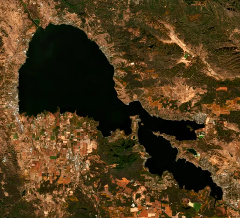
Clear Lake, in Lake County north of Calistoga and the Napa Valley wine country, is the largest natural freshwater lake entirely within California. Towns such as Lakeport and Clearlake sit on its shores, the old volcano of Mount Konocti rises from the south side, and bass anglers know it as one of the best largemouth lakes in the country.
Clear Lake is a natural lake, not a reservoir. Sediment cores suggest a lake has filled this basin for at least 480,000 years. It sits in the Clear Lake Volcanic Field, which also takes in The Geysers geothermal area, and Mount Konocti, the largest volcano in the field, stands at the middle of the south shore. The lake once drained west toward the Russian River. A landslide blocked that valley, and the water rose until it found a new way out to the east, down Cache Creek to the Sacramento River. Runoff and springs around Soda Bay keep it supplied.
The lake has three arms. The Upper Arm is the largest and collects about three quarters of the drainage from the surrounding hills. The other two are the Oaks Arm and the Lower Arm, and Cache Creek, the only outlet, leaves from the Lower Arm.
Pomo, Lake Miwok and Wappo peoples lived around the lake long before settlers arrived in the 1840s. Two of those settlers, Andrew Kelsey and Charles Stone, enslaved and abused Pomo workers, and in 1849 Pomo men killed them. On May 15, 1850, U.S. Army dragoons led by Lieutenants Nathaniel Lyon and John Wynn Davidson attacked a Pomo camp on an island at the north end of the lake, called Bo-no-po-ti. Most of those killed were old men, women and children. Estimates of the dead range from about 60 to several hundred. The lake has since pulled back, and the island is now a hill in reclaimed land southeast of the town of Upper Lake. The site is a California Historical Landmark, marked at Highway 20 and Reclamation Road. An earlier marker from 1942 called the attack a battle; State Parks and the Lucy Moore Foundation placed a new one in 2005.
Largemouth bass make up about two thirds of the fish caught, and national bass groups have ranked Clear Lake at or near the top of the country's bass lakes. Anglers also catch crappie, bluegill, channel catfish and Sacramento perch. The native Clear Lake hitch once ran up the feeder creeks in such numbers that millions crowded the streams, and in 2024 the State Water Board ordered farms in Big Valley to report their water use so its effect on hitch spawning could be studied.
The lake has a troubled environmental record. To fight swarms of gnats that drove away summer visitors, the pesticide DDD was sprayed in 1949, 1954 and 1957, and western grebes were later found dead with high levels of it in their bodies. Mercury from the nearby Sulphur Bank Mine, a Superfund site since the early 1990s, is still being cleaned up. Blooms of toxic cyanobacteria often run from spring into fall, and a task force formed in 2014 tracks them, so it is worth checking current advisories before swimming. Every boat must pass a quagga and zebra mussel inspection and carry a Lake County sticker before launching.
Locals talk about the lake level in feet Rumsey, not elevation. Zero on the Rumsey gauge marks the point at which the lake stopped flowing over the rock ledge at Grigsby Riffle. Court decrees from 1920 and 1942 set a normal maximum of 7.56 feet Rumsey. Yolo County, downstream, owns the Cache Creek Dam and may draw water from the lake between May and October. In a full year it can pull the lake down about 3.5 feet. When the lake starts May below about 3.2 feet Rumsey, no water may be drawn at all.
Written by Lake by Lake from California Department of Parks and Recreation, California Office of Historic Preservation and Wikipedia (Clear Lake (California), Bloody Island massacre). Checked November 2026.
Where the level comes from: CLEAR LK A LAKEPORT CA (U.S. Geological Survey).
| Lake | Miles | Level (ft) | vs full | 7 days |
|---|---|---|---|---|
| Lake Mendocino Well below full | 18 | 722.84 | −41.96 | −0.56 |
| Indian Valley Reservoir Well below full | 20 | 1457.92 | −27.08 | +0.21 |
| Lake Sonoma Below full | 22 | 442.37 | −8.73 | −0.43 |
| Lake Berryessa Slightly below full | 57 | 427.25 | −12.75 | −0.05 |
| Milliken Reservoir Live reading | 59 | 900.71 | — | +0.42 |
| Black Butte Lake Well below full | 62 | 436.51 | −36.99 | +0.44 |
Compare Clear Lake with Lake Mendocino, Indian Valley Reservoir, Lake Sonoma or Lake Berryessa: size, level, ramps and fish side by side.
Clear Lake is about 43 mi from Santa Rosa, CA. See all the lakes near each city.
Clear Lake is at 1,322.62 feet above sea level, as of Nov 18, 2026, 9:15 PM PST. It has risen 0.17 ft in the past 7 days.
Clear Lake has 29 boat ramps on our map, including Boat ramp at Lakeport Park 4th Of July, Boat ramp at Library Park, Lucerne Boat Launch, and 6 marinas. Low water can close ramps, so check today's level above and the operator before you go.
Yes. There are 20 campgrounds and RV parks within about a mile of the shore, such as Lucerne On the Lake, Aurora RV Park, Lake Place Resort.
Game fish recorded in Clear Lake include bluegill, largemouth bass, white catfish, black crappie, white crappie, channel catfish. In all, 32 fish species have open records inside the lake on GBIF.
The surface of Clear Lake was about 57°F on November 16, estimated from a satellite pass on a clear day. It is the top layer of the water, a few degrees either way; coves and shallows run warmer in the sun.
Anglers 16 and older need a California fishing license, sold online by the California Department of Fish and Wildlife. Free fishing days: Two Saturdays a year (2027: July 3 and September 4). Size and bag limits can be set lake by lake: check the current regulations.
Clear Lake averages about 26 ft deep. Depth changes with the lake level.
In summer a white Secchi disk lowered into Clear Lake stays visible to about 2.2 ft (the median of 223 readings, 2016–2022, by Big Valley Band of Pomo Indians of the Big Valley Rancheria, California): murky water. Silt after rain lowers the reading as much as algae do. Clarity drops after storms and during algae blooms.
boating (29 boat ramps and 6 marinas), kayaks, boats & jet skis (3 rental outfits on or near the water), fishing (14 game fish and 1 fishing guide), swimming (4 beaches and swimming areas), hiking & walking (3 trails along the shore, the longest Vic Barnes Nature Trail (1.7 mi)) and camping (20 campgrounds), according to our map of the shore.
EPA's CyAN satellite rated cyanobacteria in Clear Lake not detected on November 8. The satellite sees open water only; blooms can be patchy, so avoid water that looks like spilled paint or pea soup and keep dogs out of scum. Swimming advisories come from California health and environment agencies.
Yes. 3 trails run along or near the shore, including Kelsey Creek Trail (0.5 mi), Dorn Nature Trail (0.9 mi) and Vic Barnes Nature Trail (1.7 mi), according to OpenStreetMap.
From the U.S. Geological Survey (CLEAR LK A LAKEPORT CA). Lake by Lake checks it every hour; the agency's own figure is always the reference, and provisional readings can be revised.
Lake levels are refreshed every hour. Texas and California reservoirs report once a day; most USGS and NOAA gauges report every 15 to 60 minutes.
Cookies for analytics With your OK we use Google Analytics and Microsoft Clarity to count visits and see how the site is used, so we can make it better. No advertising cookies. Privacy policy




