Sun
- Sunrise
- 6:07 AM
- Sunset
- 4:41 PM
- First light
- 5:41 AM
- Last light
- 5:06 PM
Reservoir · Jackson County, Florida
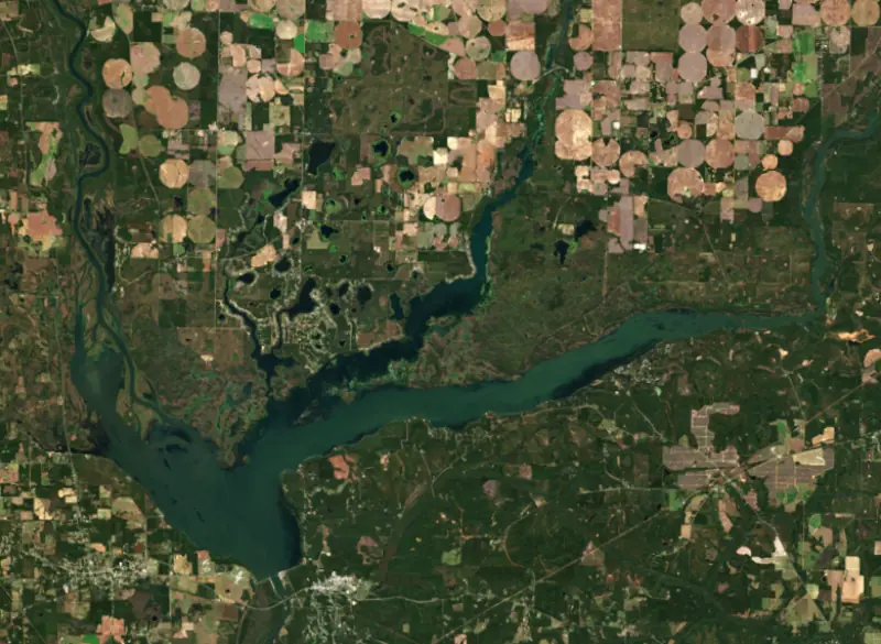
A reservoir on the Apalachicola in Jackson County, Florida, held back by Jim Woodruff Lock and Dam since 1954.

Lake Seminole is at 76.67 feet above sea level — 1.33 ft below normal pool, as of Nov 17, 2026, 8:00 PM CST. The level has held steady over the past week.
Lowest of 4 Florida lakes today against full pool · See the ranking
Record low 75.83 ft (2015), record high 77.86 ft (2020) · Level history since 2007
A notification from this browser, once, when the level crosses the line (checked every hour). No account and no email. On an iPhone, add Lake by Lake to your home screen first (Share → Add to Home Screen) and open it from there. Or follow the lake in a feed reader: RSS feed.
Lake Seminole is down 0.18 ft over the last 30 days, at 76.67 ft today.
Daily values from the U.S. Geological Survey.
Over the past 12 months, Lake Seminole ranged from 76.22 ft (Apr 22, 2026) to 77.57 ft (Jun 2, 2026), a swing of 1.3 ft. Today's level is in the lower half of that range. It is 0.08 ft lower than on this date last year.
Daily values from the U.S. Geological Survey. Why lake levels rise and fall
In the U.S. Geological Survey record, which starts in 2007, the lowest level was 75.83 ft on May 11, 2015 and the highest 77.86 ft on January 21, 2020. Today’s 76.67 ft is 0.8 ft above the record low and 1.2 ft below the record high.
Lake Seminole level history: every year since 2007, the lowest and highest years →
Solunar periods for Lake Seminole, local time. How they work
Not detected · as of Nov 9, 2026
The satellite found no cyanobacteria at the surface.
Week of Aug 16Week of Nov 1
Each bar is one week, colored by the worst reading of that week.
From the U.S. EPA's Cyanobacteria Assessment Network (CyAN), which reads the color of lakes from the Sentinel-3 satellites; it sees open water only, not coves or the shoreline. Blooms can be patchy: what you see on the water matters more. Swimming closures and health advisories come from Florida health and environment agencies. How to read it
Surface water temperature
69°F on Nov 12, 2026
90°F · Jul 1969°F · Nov 12
20°F cooler than on Jul 19, 2026.
Estimated from MODIS Aqua (NASA) passes on clear days: the top layer of the water, a few degrees either way. Coves and the shallows can be warmer.
Lake Seminole water temperature: trend, swimming and the fish →
On or near the shore of Lake Seminole: 28 boat ramps, 3 marinas, 1 rental outfit, 14 campgrounds, 3 trails and 1 fishing guide. The lake has about 289 miles of shoreline, counting its islands.
Tap an icon for details; use two fingers (or Ctrl + scroll) to move the map. Tap a dot for details. Map and lake outline © OpenStreetMap contributors. Places from OpenStreetMap, Overture Maps and Recreation.gov. Not for navigation.
What you’ll find on the shore
← AllBoating 31
← AllRentals & tours 1
← AllFishing spots 6
← AllCamping 14
← AllLodging 13
← AllTrails 3
← AllParks 10
← AllDining 6
These invasive plants and animals have been recorded in Lake Seminole: clean, drain and dry everything before you go to another lake.
Florida: Florida has no clean-drain-dry law, but FWC asks boaters to remove plants from boats, trailers and livewells before entering or leaving any water and to clean, drain and dry. Possessing or moving prohibited aquatic plants such as hydrilla without a permit is illegal. State rules
Records: USGS Nonindigenous Aquatic Species database. A species not listed may still be present.
Lake Seminole is the reservoir where the Chattahoochee and Flint rivers meet, on the line between southwest Georgia and the Florida Panhandle. The Army Corps of Engineers' Jim Woodruff Lock and Dam holds it back just below the meeting of the rivers, where the Apalachicola River begins. It is known for largemouth bass, thick beds of water plants and wintering ducks.
The River and Harbor Act of 1946 approved a plan to improve the Apalachicola, Chattahoochee and Flint rivers for navigation, power and river flow, and this dam was the first project built under it. The act referred to the site as Junction Dam and directed that it be named the Jim Woodruff Dam once finished. James W. Woodruff, born in Columbus, Georgia, in 1879, had worked for decades toward a navigable three-river system. Construction began in 1947, and the powerhouse came on line in 1957.
The dam stands on the state line about 1,000 feet below the point where the two rivers join, roughly a mile northwest of the town of Chattahoochee, Florida. Its lock lets boats pass between the lake and the Apalachicola, which flows on to the Gulf of Mexico. The Corps' site office and visitor center are just north of Chattahoochee on Booster Club Road.
The ground beneath the lake is riddled with karst. Builders found sinkholes on land and on the lake bottom, along with streams that vanish and reappear, and excavated and grouted them during construction. Even so, the dam has a long history of heavy seepage at its western end and beneath the fixed-crest spillway, and seepage through Polk Lake accounts for about half of the water that boils up in the Apalachicola below. In 2018 the U.S. Geological Survey mapped the site with radar and electrical surveys to trace the hidden paths the water takes.
The lake reaches about 30 miles up the Chattahoochee and about 35 miles up the Flint, with the Spring Creek arm between them. Hydrilla, a non-native water plant, arrived in the 1960s and came to choke the shallows. By 1997 it covered 76 percent of the Spring Creek arm, hurting water quality, slowing fish growth and blocking boats. In May 2000 the Corps began treating Spring Creek with herbicide under a Hydrilla Action Plan meant to hold the plant to 20 to 40 percent of the lake's surface and bring back native vegetation. Within two years pondweeds and eelgrass were returning, young largemouth bass were growing faster, and anglers were spending more time fishing Spring Creek. Georgia biologists found the wintering ducks had not left, only moved to other parts of the lake.
Georgia's fisheries biologists rate largemouth bass, redear sunfish, black crappie, and channel and blue catfish as the lake's best bets.
Seminole State Park, near Donalsonville in Seminole County, wraps around a small cove where the water is often calm enough for skiing and tubing. It has cottages near the water, campsites, a sand swimming beach, boat ramps, a fishing dock and a nature trail that passes gopher tortoise burrows in one of the largest longleaf pine forests of any Georgia state park. Alligators, ospreys and bald eagles live around the lake, and nearby wildlife management areas, among them Lake Seminole and Silver Lake, draw duck and deer hunters.
Written by Lake by Lake from U.S. Army Corps of Engineers, Mobile District (ACF River System history, Hydropower), U.S. Geological Survey, Georgia State Parks, Georgia DNR Wildlife Resources Division and The Chattanoogan (Georgia DNR release). Checked November 2026.
Activities listed by the U.S. Army Corps of Engineers: Biking · Boating · Camping · Fishing · Hiking · Picnicking · Water sports · Wildlife viewing
Jim Woodruff Lock and Dam is a concrete gravity dam 67 feet high and 7,000 feet long on the Apalachicola, completed in 1954. It belongs to the U.S. Army Corps of Engineers (Mobile District) and is run for navigation, recreation, hydropower and flood control. At its normal level the reservoir holds 406,200 acre-ft, drained from 17,200 square miles of land.
From the National Inventory of Dams (U.S. Army Corps of Engineers), NID ID FL00435. Lake or reservoir: what’s the difference?
Where the level comes from: LAKE SEMINOLE NEAR CHATTAHOOCHEE, FL (U.S. Geological Survey).
| Lake | Miles | Level (ft) | vs full | 7 days |
|---|---|---|---|---|
| Lake Talquin At or near full pool | 26 | 68.56 | +0.06 | +0.01 |
| Lake Iamonia Live reading | 39 | 93.04 | — | — |
| Deer Point Lake Live reading | 54 | 3.63 | — | −0.78 |
| Lake Miccosukee Live reading | 54 | 74.84 | — | — |
| Walter F. George Lake Slightly below full | 64 | 186.40 | −3.60 | −0.05 |
Compare Lake Seminole with Lake Talquin, Lake Iamonia, Deer Point Lake or Lake Miccosukee: size, level, ramps and fish side by side.
Lake Seminole is about 40 mi from Tallahassee, FL. See all the lakes near each city.
Lake Seminole is at 76.67 feet above sea level — 1.33 ft below normal pool, as of Nov 17, 2026, 8:00 PM CST. The level has held steady over the past week.
Lake Seminole's normal pool is 78.00 ft, according to U.S. Army Corps of Engineers. Today the lake is 1.33 ft below that mark.
Today's level is 0.10 ft below the median for this date (76.77 ft), from the gauge’s long-term daily record.
75.83 ft, on May 11, 2015, in the U.S. Geological Survey record, which starts in 2007. Today the lake is 0.8 ft above that.
77.86 ft, on January 21, 2020, in the U.S. Geological Survey record since 2007.
Lake Seminole has 28 boat ramps on our map, including Cumming's Landing, Faceville Landing, Georgia - Lake Seminole Recreation Area - Chattahoochee Park, and 3 marinas. Low water can close ramps, so check today's level above and the operator before you go.
Yes. There are 14 campgrounds and RV parks within about a mile of the shore, such as Rays Lake Park Campground, Hales Landing Camp Ground, Faceville Landing Park.
The surface of Lake Seminole was about 69°F on November 12, estimated from a satellite pass on a clear day. It is the top layer of the water, a few degrees either way; coves and shallows run warmer in the sun.
Anglers 16 and older need a Florida fishing license, sold online by the Florida Fish and Wildlife Conservation Commission. Free fishing days: First weekend in April and second weekend in June. Size and bag limits can be set lake by lake: check the current regulations.
Lake Seminole is about 30 ft deep at its deepest point, usually near the dam, and about 20 ft deep on average. Depth changes with the lake level.
In summer a white Secchi disk lowered into Lake Seminole stays visible to about 4.2 ft (the median of 132 readings, 2016–2026, by Georgia DNR Environmental Protection Division and FL Dept. of Environmental Protection): somewhat murky water. With the algae measured too (chlorophyll about 12 µg/L), that makes it eutrophic: rich in nutrients, greener water. Clarity drops after storms and during algae blooms.
U.S. Army Corps of Engineers lists biking, boating, camping, fishing, hiking, picnicking, water sports and wildlife viewing at Lake Seminole. 5 campgrounds can be booked on Recreation.gov.
EPA's CyAN satellite rated cyanobacteria in Lake Seminole not detected on November 9. The satellite sees open water only; blooms can be patchy, so avoid water that looks like spilled paint or pea soup and keep dogs out of scum. Swimming advisories come from Florida health and environment agencies.
Yes. 3 trails run along or near the shore, including Lakeview Trail (1.1 mi), Riverwalk Trail (1.3 mi) and Gopher Tortoise Trail (0.9 mi), according to OpenStreetMap.
Lake Seminole is held back by Jim Woodruff Lock and Dam, completed in 1954 and 67 ft high, according to the National Inventory of Dams.
From the U.S. Geological Survey (LAKE SEMINOLE NEAR CHATTAHOOCHEE, FL). Lake by Lake checks it every hour; the agency's own figure is always the reference, and provisional readings can be revised.
Lake levels are refreshed every hour. Texas and California reservoirs report once a day; most USGS and NOAA gauges report every 15 to 60 minutes.