Sun
- Sunrise
- 7:40 AM
- Sunset
- 5:07 PM
- First light
- 7:08 AM
- Last light
- 5:39 PM
Lake · Roscommon County, Michigan
A lake in Roscommon County, Michigan.

Higgins Lake is at 1,153.41 feet above sea level, as of Nov 19, 2026, 1:00 AM EST. It has dropped 0.12 ft in the past 7 days.
A notification from this browser, once, when the level crosses the line (checked every hour). No account and no email. On an iPhone, add Lake by Lake to your home screen first (Share → Add to Home Screen) and open it from there. Or follow the lake in a feed reader: RSS feed.
Higgins Lake is down 0.12 ft over the last 7 days, at 1,153.41 ft today.
Daily values from the U.S. Geological Survey.
Higgins Lake is down 0.27 ft over the last 30 days, at 1,153.41 ft today.
Daily values from the U.S. Geological Survey.
Over the past 257 days, Higgins Lake ranged from 1,153.44 ft (Nov 18, 2026) to 1,154.38 ft (Apr 16, 2026), a swing of 0.9 ft. Today's level is the lowest of the past 257 days.
Daily values from the U.S. Geological Survey. Why lake levels rise and fall
Solunar periods for Higgins Lake, local time. How they work
Not detected · as of Nov 4, 2026
The satellite found no cyanobacteria at the surface.
Week of Aug 16Week of Nov 1
Each bar is one week, colored by the worst reading of that week.
From the U.S. EPA's Cyanobacteria Assessment Network (CyAN), which reads the color of lakes from the Sentinel-3 satellites; it sees open water only, not coves or the shoreline. Blooms can be patchy: what you see on the water matters more. Swimming closures and health advisories come from Michigan health and environment agencies. How to read it
Surface water temperature
48°F on Nov 15, 2026
72°F · Jul 2448°F · Nov 15
24°F cooler than on Jul 24, 2026.
Estimated from MODIS Aqua (NASA) passes on clear days: the top layer of the water, a few degrees either way. Coves and the shallows can be warmer.
Higgins Lake water temperature: trend, swimming and the fish →
On or near the shore of Higgins Lake: 3 boat ramps, 3 marinas, 1 rental outfit, 2 campgrounds, 1 beach, 1 fishing pier and 2 trails. The lake has about 22 miles of shoreline, counting its islands.
Tap an icon for details; use two fingers (or Ctrl + scroll) to move the map. Tap a dot for details. Map and lake outline © OpenStreetMap contributors. Places from OpenStreetMap, Overture Maps and Recreation.gov. Not for navigation.
What you’ll find on the shore
← AllBoating 6
← AllRentals & tours 1
← AllFishing spots 1
← AllBeaches 1
← AllCamping 2
← AllLodging 11
← AllTrails 2
← AllParks 8
← AllDining 1
Zebra mussels have been found in Higgins Lake. They clog intakes and engines and spread on boats and trailers: clean, drain and dry everything before you go to another lake.
Michigan: Remove all aquatic plants from the boat, gear and trailer before launching. Before driving away, pull all drain plugs (bilge, ballast, livewell), drain all water and make sure boat and trailer are free of plants and animals; dispose of unused bait on land or in the trash. State rules
Records: USGS Nonindigenous Aquatic Species database. A species not listed may still be present.
In the last 12 months, Michigan Department of Natural Resources stocked 80,753 fish in Higgins Lake: lake trout (31,454), rainbow trout (25,799) and brown trout (23,500).
All 13 stockings · Source: Michigan Department of Natural Resources stocking records.
Species with open-licensed records inside Higgins Lake's outline, from GBIF.org (surveys, museum collections and angler reports). A record shows a fish was found here, not how many there are now. marks fish the state stocks here.
Shallow, protected flats in spring; docks, grass and deep edges in summer heat.
Rocky points, gravel and current breaks; deeper rock piles in summer.
Cool water: near the surface in spring and fall, deep in summer.
Shallow, weedy bays right after ice-out; weed edges the rest of the year.
Low light and cold water; the inflows in fall.
Water temperature sets off each spawn; the bars show the usual months at this latitude and elevation, and move with a warm or cold spring. The water is about 48°F now.
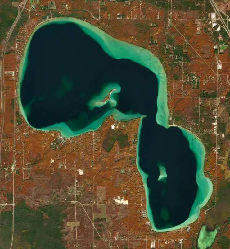
Higgins Lake is a deep, spring-fed glacial lake in Roscommon County, in the northern part of Michigan's Lower Peninsula, and Michigan's 10th largest inland lake. It lies in Lyon and Gerrish townships. People come for its cold, clear water, its trout and perch fishing, and the busy state parks at its north and south ends.
Higgins Lake sits in a hollow left by a huge block of ice that stayed behind when the last glaciers melted, on the sandy outwash plain that their meltwater spread across this part of Michigan. Groundwater, much of it from springs, supplies most of the lake's water, with North Creek, East Creek and Big Creek bringing in the rest along with rain and runoff. Water stays in the lake for about 12 years, on average, before it flows out.
Early survey parties found Native American camps along the shore. The Chippewa called the lake Majinabeesh, or sparkling water. In 1839 John Brink of the State Geological Survey mapped it as Forginson Lake, and after William A. Burt's survey of 1852 it was renamed for Sylvester Higgins, a state cartographer. Logging reached the lake around 1875, Saginaw lumber barons built summer camps on its shore, and by 1900 the pines were gone.
Water leaves Higgins Lake through a dam on its southeast side into the Cut River, which flows to Houghton Lake and on through the Muskegon River watershed to Lake Michigan.
The Roscommon County Board of Commissioners is responsible for the dam and the lake level. A summer legal level was first set in 1926, and in 1982 a Roscommon County Circuit Court order confirmed it and set a winter level half a foot lower. In 2007 the structure was altered to add tilting gates and a narrow low-flow channel that cannot be closed. A later engineering study for the county found that summer levels usually ran a little short of the legal mark, mostly from evaporation and from water slipping through that channel. Shoreline owners sued, and in 2022 the Michigan Court of Appeals held that the county has a clear duty to keep the summer level the court set, though how it does so is up to the county.
South Higgins Lake State Park opened in 1927 and is the larger and busier of the two parks. North Higgins Lake State Park, opened in 1963, sits on the grounds of a seedling nursery started by the state forester in 1903, which grew into the largest of its kind in the world. On December 5, 1933, the Civilian Conservation Corps set up a camp at Higgins Lake, and the camp and nursery were at the heart of the corps' work planting trees and fighting forest fires across northern Michigan. By 1942 about 100,000 Michigan enrollees had planted 484 million trees. The Civilian Conservation Corps Museum, in a replica barracks on former nursery land, tells the story. Both parks have boat launches and campgrounds and fill up in summer.
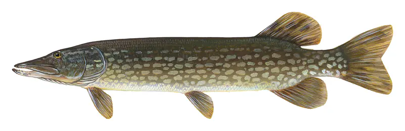
Higgins Lake has one island, but the state's fishing reports also name its sunken islands. In late spring, perch fishermen work 15 to 30 feet of water near Treasure Island and the south Sunken Island, mostly with minnows, while others long-line for trout. In winter the ice gives up lake trout and smelt. The lake also holds walleye, smallmouth bass, northern pike, whitefish and brown and rainbow trout, and the state has stocked lake and brown trout since 1979 and rainbows as well in later years.
The deep basins stay low in nutrients, but nitrogen and phosphorus run higher near shore, most likely from septic systems, and a 2020 study for Lyon Township recommended a sewer around the lake.
Written by Lake by Lake from Lyon Township, Roscommon County, Huron Pines, Michigan Court of Appeals, The Living New Deal and Michigan Department of Natural Resources (Weekly Fishing Report, May 30, 2019, Weekly Fishing Report, February 2, 2022). Checked November 2026.
Where the level comes from: HIGGINS LAKE NEAR ROSCOMMON, MI (U.S. Geological Survey).
| Lake | Miles | Level (ft) | vs full | 7 days |
|---|---|---|---|---|
| Houghton Lake Live reading | 6 | 1137.43 | — | +0.01 |
| Lake St. Helen Live reading | 13 | 1154.44 | — | −0.10 |
| Otsego Lake Live reading | 35 | 1273.24 | — | −0.02 |
| Van Etten Lake Live reading | 66 | 585.90 | — | −0.71 |
| Mullett Lake Live reading | 80 | 592.41 | — | −0.07 |
Compare Higgins Lake with Houghton Lake, Lake St. Helen, Otsego Lake or Van Etten Lake: size, level, ramps and fish side by side.
Higgins Lake is at 1,153.41 feet above sea level, as of Nov 19, 2026, 1:00 AM EST. It has dropped 0.12 ft in the past 7 days.
Higgins Lake has 3 boat ramps on our map, including Higgins Lake West, North Higgins Lake State Park, South Higgins Lake State Park, and 3 marinas. Low water can close ramps, so check today's level above and the operator before you go.
Yes. There are 2 campgrounds and RV parks within about a mile of the shore, such as Camp Westminster on Higgins Lake, South Higgins Lake Campground.
Game fish recorded in Higgins Lake include yellow perch, lake trout, northern pike, smallmouth bass, brown trout, rainbow trout. In all, 26 fish species have open records inside the lake on GBIF.
The surface of Higgins Lake was about 48°F on November 15, estimated from a satellite pass on a clear day. It is the top layer of the water, a few degrees either way; coves and shallows run warmer in the sun.
Anglers 17 and older need a Michigan fishing license, sold online by the Michigan Department of Natural Resources. Free fishing days: Presidents' Day weekend (Sat-Sun) and the Saturday and Sunday after the first full week of June. Size and bag limits can be set lake by lake: check the current regulations.
In summer a white Secchi disk lowered into Higgins Lake stays visible to about 34.0 ft (the median of 139 readings, 2016–2023, by Michigan EGLE - MiCorps and North American Lake Management Society): very clear water. With the algae measured too (chlorophyll about 1 µg/L), that makes it oligotrophic: clear, low in nutrients. Clarity drops after storms and during algae blooms.
boating (3 boat ramps and 3 marinas), kayaks, boats & jet skis (1 rental outfit on or near the water), fishing (13 game fish and 1 fishing pier or spot; stocked by the state), swimming (1 beach or swimming area), hiking & walking (2 trails along the shore, the longest Marl Lake Green Trail (1.9 mi)) and camping (2 campgrounds), according to our map of the shore.
EPA's CyAN satellite rated cyanobacteria in Higgins Lake not detected on November 4. The satellite sees open water only; blooms can be patchy, so avoid water that looks like spilled paint or pea soup and keep dogs out of scum. Swimming advisories come from Michigan health and environment agencies.
Yes. Michigan Department of Natural Resources stocked brown trout, rainbow trout and lake trout in Higgins Lake; the latest stocking on record was on April 16, 2026.
Yes. 2 trails run along or near the shore, including North Higgins Lake Trail Connector (1.2 mi) and Marl Lake Green Trail (1.9 mi), according to OpenStreetMap.
From the U.S. Geological Survey (HIGGINS LAKE NEAR ROSCOMMON, MI). Lake by Lake checks it every hour; the agency's own figure is always the reference, and provisional readings can be revised.
Lake levels are refreshed every hour. Texas and California reservoirs report once a day; most USGS and NOAA gauges report every 15 to 60 minutes.
Cookies for analytics With your OK we use Google Analytics and Microsoft Clarity to count visits and see how the site is used, so we can make it better. No advertising cookies. Privacy policy