Sun
- Sunrise
- 6:36 AM
- Sunset
- 4:52 PM
- First light
- 6:09 AM
- Last light
- 5:19 PM
Reservoir · Panola County, Mississippi
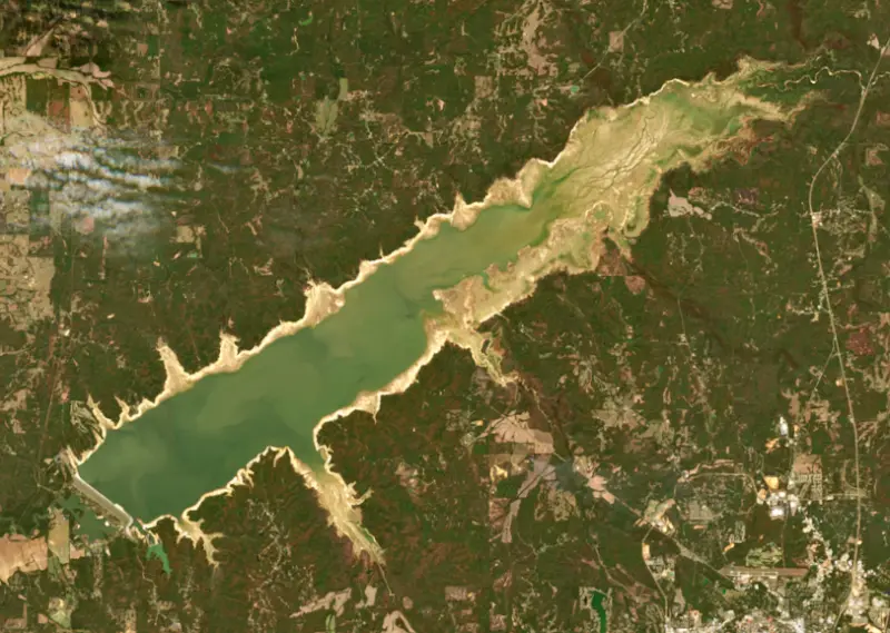
A reservoir on the Little Tallahatchie River in Panola County, Mississippi, held back by Sardis Dam since 1940.

Sardis Lake is at 239.41 feet above sea level — 20.59 ft below summer pool, as of Nov 19, 2026, 2:00 AM CST. It has dropped 3.79 ft in the past 7 days.
Lowest of 5 Mississippi lakes today against full pool · See the ranking
Record low 234.66 ft (2006), record high 280.50 ft (2002) · Level history since 1999
A notification from this browser, once, when the level crosses the line (checked every hour). No account and no email. On an iPhone, add Lake by Lake to your home screen first (Share → Add to Home Screen) and open it from there. Or follow the lake in a feed reader: RSS feed.
Sardis Lake is down 3.79 ft over the last 7 days, at 239.41 ft today.
Daily values from the NOAA National Water Prediction Service.
Sardis Lake is down 9.12 ft over the last 30 days, at 239.41 ft today.
Daily values from the NOAA National Water Prediction Service.
Over the past 12 months, Sardis Lake ranged from 236.07 ft (Dec 9, 2025) to 261.07 ft (Jul 29, 2026), a swing of 25.0 ft. Today's level is near the bottom of that range. It is 0.54 ft higher than on this date last year.
Daily values from the NOAA National Water Prediction Service. Why lake levels rise and fall
In the U.S. Army Corps of Engineers record, which starts in 1999, the lowest level was 234.66 ft on January 9, 2006 and the highest 280.50 ft on May 15, 2002. Today’s 239.41 ft is 4.8 ft above the record low and 41.1 ft below the record high.
Sardis Lake level history: every year since 1999, the lowest and highest years →
Solunar periods for Sardis Lake, local time. How they work
Not detected · as of Nov 9, 2026
The satellite found no cyanobacteria at the surface.
Week of Aug 16Week of Nov 1
Each bar is one week, colored by the worst reading of that week.
From the U.S. EPA's Cyanobacteria Assessment Network (CyAN), which reads the color of lakes from the Sentinel-3 satellites; it sees open water only, not coves or the shoreline. Blooms can be patchy: what you see on the water matters more. Swimming closures and health advisories come from Mississippi health and environment agencies. How to read it
Surface water temperature
63°F on Nov 12, 2026
89°F · Jul 3063°F · Nov 12
26°F cooler than on Jul 30, 2026.
Estimated from Landsat 8/9 (USGS) passes on clear days: the top layer of the water, a few degrees either way. Coves and the shallows can be warmer.
Sardis Lake water temperature: trend, swimming and the fish →
On or near the shore of Sardis Lake: 12 boat ramps, 1 marina, 14 campgrounds and 4 trails. The lake has about 90 miles of shoreline, counting its islands.
Tap an icon for details; use two fingers (or Ctrl + scroll) to move the map. Tap a dot for details. Map and lake outline © OpenStreetMap contributors. Places from OpenStreetMap, Overture Maps and Recreation.gov. Not for navigation.
What you’ll find on the shore
← AllBoating 13
← AllFishing spots 3
← AllCamping 14
← AllLodging 1
← AllTrails 4
← AllParks 10
← AllDining 2
These invasive plants and animals have been recorded in Sardis Lake: clean, drain and dry everything before you go to another lake.
Mississippi: Mississippi has no clean-drain-dry law; MDWFP asks boaters to clean plants, animals and mud off gear, drain boats, livewells and bait buckets, dry everything, and never move fish or plants between waters. Zebra mussels are a prohibited species and may not be possessed or moved. State rules
Records: USGS Nonindigenous Aquatic Species database. A species not listed may still be present.
Species with open-licensed records inside Sardis Lake's outline, from GBIF.org (surveys, museum collections and angler reports). A record shows a fish was found here, not how many there are now.
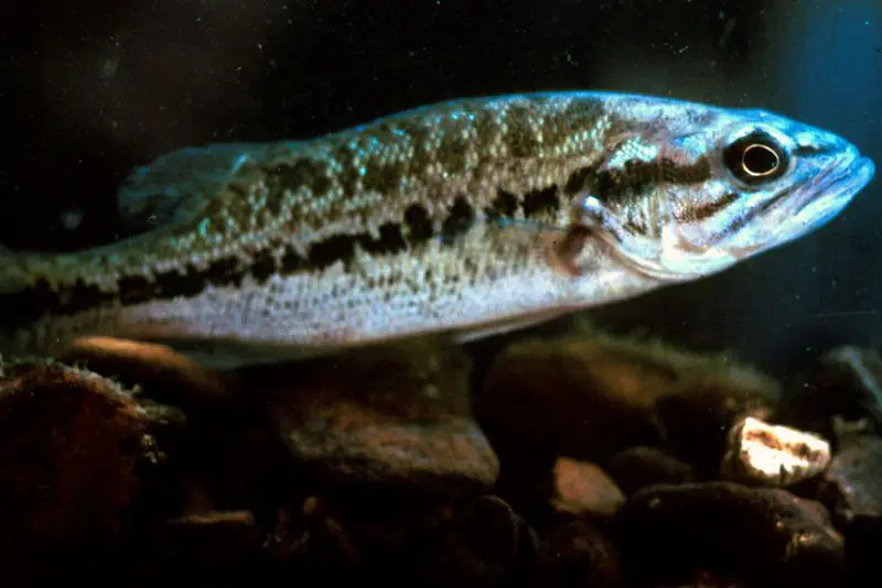
Brush piles, docks and bridge pilings; shallow for a few weeks in spring.
Channel edges and river arms; best after dark in summer, and after a rain.
Run up the river arms in spring; follow shad to cool, deep water near the dam in summer.
Clear water and steep rock; they often suspend deeper than largemouth.
Beds in shallow, firm bottoms; around docks and weeds all summer.
Water temperature sets off each spawn; the bars show the usual months at this latitude and elevation, and move with a warm or cold spring. The water is about 63°F now.
Sardis Lake is a flood control reservoir on the Little Tallahatchie River in north Mississippi, spreading across Panola, Lafayette and Marshall counties about 12 miles northwest of Oxford. It is the oldest of the four big Corps of Engineers lakes in the hills above the Delta, and Mississippi's wildlife agency calls it the most popular fishing destination in the state. Crappie are the main reason.
The Mississippi River flood of 1927 pushed Congress into flood control on a new scale, and the Flood Control Act of 1936 authorized a set of reservoirs on the Yazoo River headwaters to keep hill-country runoff from swamping the Delta. Sardis Dam was the first of them, and the others became Arkabutla, Enid and Grenada lakes. The Corps of Engineers began work in the late 1930s as a New Deal project, and the dam was built by hydraulic fill, with a Corps dredge named the Pontotoc pumping soil from below the site into a long earthen embankment. The dredging left a separate body of water below the dam, now called the Lower Lake. During the Depression the job gave many Panola County men their first paid work, often at 50 cents an hour. The reservoir covered bottomland farms along the river, and families who lived there had to move. The dam stands about 9 miles southeast of the town of Sardis.
Sardis was built to store floodwater, and its level shows it. The Corps follows a seasonal rule curve, lowering the lake each fall to a small winter pool and letting it rise again toward summer pool. In a normal year the surface moves about 24 feet, and the lake's footprint changes from roughly a third of its summer size in winter to far beyond it in a flood. The emergency spillway has been overtopped only three times, in 1973, 1983 and 1991. Local rain and gate releases often push the level off the curve, and state biologists note that the swings can make fish hard to find and pattern.
Most Sardis anglers come for crappie, usually trolling open water with many poles at once, a method known as spider rigging, and winter crappie fishing has been growing. The state biologist's surveys find both white and black crappie, and Sardis has its own rules for them, including a 12-inch minimum length on the main reservoir that does not apply in the spillway or the Lower Lake. Largemouth bass numbers rose to the highest the state has recorded at Sardis after spring flooding from 2018 on improved the shoreline habitat where bass spawn and their young grow, and most anglers here release their bass. Blue catfish of good size are common, and catfish, white bass and bream round out the catch. The state suggests working shoreline cover in creek arms and coves in spring, trolling creek mouths and the main lake in summer and fall, and moving deeper when the water is falling. About a quarter of the anglers drive down from the Memphis area. The spillway below the dam is a separate fishery whose crappie depend on releases from the lake and bite mostly in winter and early spring.
The state park that opened beside the lake as Sardis Lake State Park was later renamed John W. Kyle State Park. Its lodge, cabins and boat launch sit on the main lake, while the campground is on the Lower Lake below the dam, and the park also has the 18-hole Mallard Pointe golf course. The park is about an hour from Memphis and a little over 20 miles from the University of Mississippi campus. There are 12 concrete ramps around the reservoir, and bait shops in Oxford, Sardis, Batesville and Holly Springs serve the lake.
Written by Lake by Lake from Mississippi Department of Wildlife, Fisheries, and Parks (Sardis Reservoir 2025 Reel Facts, John W. Kyle State Park), The Panolian, The Living New Deal and Wikipedia. Checked November 2026.
Activities listed by the U.S. Army Corps of Engineers: Biking · Boating · Camping · Fishing · Hiking · Picnicking · Water sports · Wildlife viewing
Sardis Dam is an earthfill dam 97 feet high and 15,300 feet long on the Little Tallahatchie River, completed in 1940. It belongs to the U.S. Army Corps of Engineers (Vicksburg District) and is run for flood control and recreation. At its normal level the reservoir holds 108,000 acre-ft, drained from 1,545 square miles of land.
From the National Inventory of Dams (U.S. Army Corps of Engineers), NID ID MS01493. Lake or reservoir: what’s the difference?
Where the level comes from: Tallahatchie River at Sardis Dam (NOAA National Water Prediction Service).
| Lake | Miles | Level (ft) | vs full | 7 days |
|---|---|---|---|---|
| Enid Lake Well below full | 18 | 233.18 | −16.82 | −2.63 |
| Arkabutla Lake Below full | 31 | 205.32 | −14.68 | +0.86 |
| Grenada Lake Well below full | 41 | 196.94 | −18.06 | −2.47 |
Compare Sardis Lake with Enid Lake, Arkabutla Lake or Grenada Lake: size, level, ramps and fish side by side.
Sardis Lake is about 50 mi from Memphis, TN. See all the lakes near each city.
Sardis Lake is at 239.41 feet above sea level — 20.59 ft below summer pool, as of Nov 19, 2026, 2:00 AM CST. It has dropped 3.79 ft in the past 7 days.
Sardis Lake's summer pool is 260.00 ft, according to U.S. Army Corps of Engineers. Today the lake is 20.59 ft below that mark.
Today's level is 1.89 ft below the median for this date (241.30 ft), from the gauge’s long-term daily record.
234.66 ft, on January 9, 2006, in the U.S. Army Corps of Engineers record, which starts in 1999. Today the lake is 4.8 ft above that.
280.50 ft, on May 15, 2002, in the U.S. Army Corps of Engineers record since 1999. That is 20.5 ft above summer pool.
Sardis Lake has 12 boat ramps on our map, including Boat ramp at Coontown Crossing Public Use Area, Boat ramp at Wyatt Crossing Public Use Area, Boat ramp near Clear Creek Campground, and 1 marina. Low water can close ramps, so check today's level above and the operator before you go.
Yes. There are 14 campgrounds and RV parks within about a mile of the shore, such as Beach Point Public Use Area, Clear Creek Campground, Engineer Point Campground.
Game fish recorded in Sardis Lake include channel catfish, flathead catfish, bluegill, white crappie, striped bass, spotted bass. In all, 19 fish species have open records inside the lake on GBIF.
The surface of Sardis Lake was about 63°F on November 12, estimated from a satellite pass on a clear day. It is the top layer of the water, a few degrees either way; coves and shallows run warmer in the sun.
Anglers 16 and older need a Mississippi fishing license, sold online by the Mississippi Department of Wildlife, Fisheries, and Parks. Free fishing days: First weekend in June and July 4 (Mississippi residents). Size and bag limits can be set lake by lake: check the current regulations.
NOAA's flood categories for the Sardis Lake gauge: major flooding at 281.4 ft. Today the lake is 41.99 ft below the first flooding level.
In summer a white Secchi disk lowered into Sardis Lake stays visible to about 2.1 ft (the median of 17 readings, 2016–2018, by MISSISSIPPI DEPARTMENT OF ENVIRONMENTAL QUALITY and EPA National Aquatic Resources Survey (NARS)): murky water. With the algae measured too (chlorophyll about 13 µg/L), that makes it eutrophic: rich in nutrients, greener water. Clarity drops after storms and during algae blooms.
U.S. Army Corps of Engineers lists biking, boating, camping, fishing, hiking, picnicking, water sports and wildlife viewing at Sardis Lake. 8 campgrounds can be booked on Recreation.gov.
EPA's CyAN satellite rated cyanobacteria in Sardis Lake not detected on November 9. The satellite sees open water only; blooms can be patchy, so avoid water that looks like spilled paint or pea soup and keep dogs out of scum. Swimming advisories come from Mississippi health and environment agencies.
Yes. 4 trails run along or near the shore, including Beginner Loop (2.2 mi), Intermediate Loop (3.1 mi) and Expert Loop (6.0 mi), according to OpenStreetMap.
Sardis Lake is held back by Sardis Dam, completed in 1940 and 97 ft high, according to the National Inventory of Dams.
From the NOAA National Water Prediction Service (Tallahatchie River at Sardis Dam). Lake by Lake checks it every hour; the agency's own figure is always the reference, and provisional readings can be revised.
Lake levels are refreshed every hour. Texas and California reservoirs report once a day; most USGS and NOAA gauges report every 15 to 60 minutes.
Cookies for analytics With your OK we use Google Analytics and Microsoft Clarity to count visits and see how the site is used, so we can make it better. No advertising cookies. Privacy policy