Sun
- Sunrise
- 6:39 AM
- Sunset
- 4:24 PM
- First light
- 6:09 AM
- Last light
- 4:54 PM
Reservoir · Keith County, Nebraska
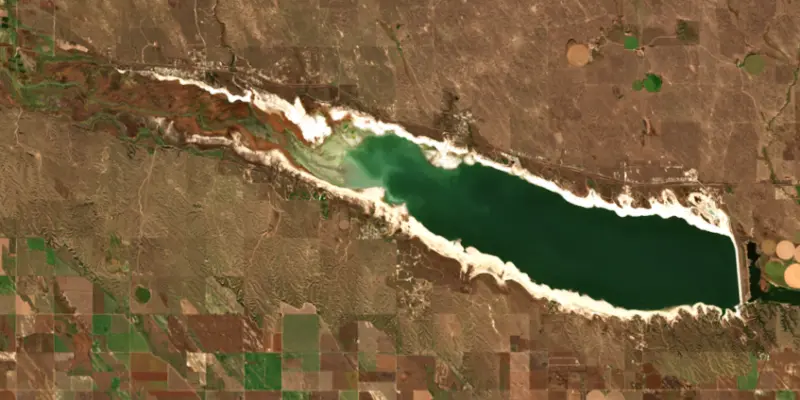
A reservoir on the North Platte River in Keith County, Nebraska, held back by Kingsley Dam since 1941.

Lake McConaughy is at 3,205.60 feet above sea level — 59.40 ft below full (top of conservation pool), as of Nov 18, 2026, 7:00 AM MST. It has risen 0.80 ft in the past 7 days.
Lowest of 21 Nebraska lakes today against full pool · See the ranking
A notification from this browser, once, when the level crosses the line (checked every hour). No account and no email. On an iPhone, add Lake by Lake to your home screen first (Share → Add to Home Screen) and open it from there. Or follow the lake in a feed reader: RSS feed.
Lake McConaughy is up 2.90 ft over the last 30 days, at 3,205.60 ft today.
Daily values from the NOAA National Water Prediction Service. Why lake levels rise and fall
Solunar periods for Lake McConaughy, local time. How they work
High · as of Nov 9, 2026
The satellite sees a likely bloom on part of the lake. Avoid discolored water and scum, and keep dogs out of it. About 673,000 cells/mL at the worst spot, covering 69% of the lake.
Week of Aug 16Week of Nov 1
Each bar is one week, colored by the worst reading of that week.
From the U.S. EPA's Cyanobacteria Assessment Network (CyAN), which reads the color of lakes from the Sentinel-3 satellites; it sees open water only, not coves or the shoreline. Blooms can be patchy: what you see on the water matters more. Swimming closures and health advisories come from Nebraska health and environment agencies. How to read it
Surface water temperature
52°F on Nov 11, 2026
80°F · Jul 2152°F · Nov 11
28°F cooler than on Jul 21, 2026.
Estimated from Landsat 8/9 (USGS) passes on clear days: the top layer of the water, a few degrees either way. Coves and the shallows can be warmer.
Lake McConaughy water temperature: trend, swimming and the fish →
On or near the shore of Lake McConaughy: 17 boat ramps, 8 campgrounds, 7 beaches and 2 trails. The lake has about 65 miles of shoreline, counting its islands.
Tap an icon for details; use two fingers (or Ctrl + scroll) to move the map. Tap a dot for details. Map and lake outline © OpenStreetMap contributors. Places from OpenStreetMap, Overture Maps and Recreation.gov. Not for navigation.
No aquatic invasive species are on record for Lake McConaughy in the USGS database. Keep it that way: clean, drain and dry your boat between lakes.
Nebraska: It is illegal to arrive at a lake with plants or animals on your boat, trailer or gear, with water that is not from a domestic source, or to move live invasive species; pull the boat plug and drain livewells and ballast at the ramp. Out-of-state motorboats must display an AIS stamp. Required: Aquatic Invasive Species stamp (out-of-state motorboats). State rules
Records: USGS Nonindigenous Aquatic Species database. A species not listed may still be present.
Species with open-licensed records inside Lake McConaughy's outline, from GBIF.org (surveys, museum collections and angler reports). A record shows a fish was found here, not how many there are now.
Brush piles, docks and bridge pilings; shallow for a few weeks in spring.
Channel edges and river arms; best after dark in summer, and after a rain.
Rocky points, gravel and current breaks; deeper rock piles in summer.
Run up the river arms in spring; follow shad to cool, deep water near the dam in summer.
Cool water: near the surface in spring and fall, deep in summer.
Water temperature sets off each spawn; the bars show the usual months at this latitude and elevation, and move with a warm or cold spring. The water is about 52°F now.
Lake McConaughy is the big reservoir on the North Platte River just north of Ogallala in Keith County, held back by Kingsley Dam. It was built in the late 1930s to store irrigation water for farms far to the east. Today most people know it for its sand beaches, its packed summer weekends and its walleye.
The idea dates to 1913, when C.W. McConaughy, a grain dealer and mayor of Holdrege, proposed running Platte River water by canal to south-central Nebraska in spring and fall, when the river was high, so the soil could hold moisture for later crops. George P. Kingsley, a Minden banker, took up the cause and worked for it until his death in 1929. Early plans for reservoirs on Plum Creek in Gosper County collapsed after a Nebraska Supreme Court ruling kept the water inside the Platte basin, so the project was redrawn around one large storage lake on the North Platte above Ogallala. Work began on March 13, 1936, paid for with a $19 million federal grant and a $24 million federal loan, which the Central Nebraska Public Power and Irrigation District paid off in 1972. McConaughy died on April 15, 1941, a few months before the dam was finished. The lake took his name and the dam took Kingsley's.
Electric dredges pumped sand from the riverbed to build the sides of the dam and a mix of loess clay and water into its core, moving more than 26 million cubic yards of earth in all. When it was completed it was the second-largest hydraulic-fill dam in the world, behind Fort Peck in Montana. Its face is covered with rock and more than 180,000 concrete jackstones that weigh 800 pounds each. Below the dam lies Lake Ogallala, a much smaller lake. In winter the churn from the hydroplant keeps its water open when everything around it freezes, and bald eagles come to fish for shad and alewife. The district's viewing building on the shore below the south end of the dam opens on weekends through the winter.
The north shore is a long run of fine sand beaches, bays and coves, while the south shore is less developed and harder to reach. For decades campers could drive onto any open stretch of sand, and on holiday weekends places like Martin Bay and Arthur Bay were packed and sometimes unruly. Alcohol was banned at the lake in 2020, and since April 2021 peak-season camping has required a reservation, with beach sites set out in designated areas. The local fire and rescue department said its calls from park visitors were cut in half that first year. The designated sites also protect least terns and piping plovers, which nest on the open sand, and some stretches are fenced off in nesting season. At the west end, the Clear Creek Wildlife Management Area draws waterfowl, shorebirds and sandhill cranes, and more than 300 bird species have been recorded around the lake.
State biologists rank McConaughy among the best walleye lakes in the Midwest, but natural reproduction is weak, so the state stocks heavily, with 26 million fry and more than 1.5 million fingerlings in 2022 alone. Alewife were introduced in 1986 to add to the gizzard shad as forage. They are now so plentiful that walleye can be hard to tempt, and they eat the zooplankton young walleye depend on. Wipers, smallmouth bass and channel catfish fill out the catch. Because the lake exists to store irrigation water, its level swings with dry and wet years, and the district has had to extend several boat ramps to reach the water during droughts.
Written by Lake by Lake from Nebraska Public Media (Nebraska Studies) (C.W. McConaughy and G.P. Kingsley, Project Construction), Central Nebraska Public Power and Irrigation District (Lake McConaughy, Eagle Viewing Facilities) and Nebraska Game and Parks Commission (Nebraskaland Magazine) (A More Family Friendly Lake McConaughy, Promise of Walleye). Checked November 2026.
Kingsley Dam is an earthfill dam 162 feet high and 17,840 feet long on the North Platte River, completed in 1941. It belongs to Central Nebraska Public Power & Irrigation District and is run for hydropower and irrigation. At its normal level the reservoir holds 1.59 million acre-ft.
From the National Inventory of Dams (U.S. Army Corps of Engineers), NID ID NE01048. Lake or reservoir: what’s the difference?
Where the level comes from: North Platte River at Kingsley Dam (NOAA National Water Prediction Service).
| Lake | Miles | Level (ft) | vs full | 7 days |
|---|---|---|---|---|
| Enders Reservoir Well below full | 55 | 3079.95 | −32.35 | −0.02 |
| Swanson Reservoir Well below full | 79 | 2734.05 | −17.95 | −0.01 |
| Hugh Butler Lake Well below full | 79 | 2564.85 | −16.95 | 0.00 |
Compare Lake McConaughy with Enders Reservoir, Swanson Reservoir or Hugh Butler Lake: size, level, ramps and fish side by side.
Lake McConaughy is at 3,205.60 feet above sea level — 59.40 ft below full (top of conservation pool), as of Nov 18, 2026, 7:00 AM MST. It has risen 0.80 ft in the past 7 days.
Lake McConaughy's full (top of conservation pool) is 3,265.00 ft, according to Central Nebraska Public Power and Irrigation District. Today the lake is 59.40 ft below that mark.
Lake McConaughy has 17 boat ramps on our map, including Arthur Bay, Diver's Bay, Martin Bay High Water. Low water can close ramps, so check today's level above and the operator before you go.
Yes. There are 8 campgrounds and RV parks within about a mile of the shore, such as Arthur Bay, Big Mac Campground, Cedar Vue Campground, Lake McConaughy.
Game fish recorded in Lake McConaughy include flathead catfish, striped bass, white bass, white crappie, smallmouth bass, rainbow trout. In all, 9 fish species have open records inside the lake on GBIF.
The surface of Lake McConaughy was about 52°F on November 11, estimated from a satellite pass on a clear day. It is the top layer of the water, a few degrees either way; coves and shallows run warmer in the sun.
Anglers 16 and older need a Nebraska fishing license, sold online by the Nebraska Game and Parks Commission. Free fishing days: Saturday before Memorial Day weekend. Size and bag limits can be set lake by lake: check the current regulations.
Lake McConaughy averages about 52 ft deep. Depth changes with the lake level.
In summer a white Secchi disk lowered into Lake McConaughy stays visible to about 6.7 ft (the median of 35 readings, 2016–2024, by Nebraska Department of Environment and Energy): clear water. With the algae measured too (chlorophyll about 5 µg/L), that makes it mesotrophic: moderately rich in nutrients. Clarity drops after storms and during algae blooms.
Yes: bathymetric and topographic contour map (plate 1) from the U.S. Geological Survey (2003). It is linked in the lake facts on this page. Depths on a map are measured at a reference level: subtract how far the lake is below it today.
boating (17 boat ramps), fishing (8 game fish), swimming (7 beaches and swimming areas), hiking & walking (2 trails along the shore), camping (8 campgrounds) and cabins & lodging (10 places to stay close to the water), according to our map of the shore.
EPA's CyAN satellite rated cyanobacteria in Lake McConaughy high on November 9. The satellite sees open water only; blooms can be patchy, so avoid water that looks like spilled paint or pea soup and keep dogs out of scum. Swimming advisories come from Nebraska health and environment agencies.
Yes. 2 trails run along or near the shore, including ADT - Nebraska - M - Seg 7 and ADT - Nebraska - M - Seg 8, according to OpenStreetMap.
Lake McConaughy is held back by Kingsley, completed in 1941 and 162 ft high, according to the National Inventory of Dams.
From the NOAA National Water Prediction Service (North Platte River at Kingsley Dam). Lake by Lake checks it every hour; the agency's own figure is always the reference, and provisional readings can be revised.
Lake levels are refreshed every hour. Texas and California reservoirs report once a day; most USGS and NOAA gauges report every 15 to 60 minutes.
Cookies for analytics With your OK we use Google Analytics and Microsoft Clarity to count visits and see how the site is used, so we can make it better. No advertising cookies. Privacy policy




