Sun
- Sunrise
- 6:41 AM
- Sunset
- 4:27 PM
- First light
- 6:11 AM
- Last light
- 4:57 PM
Lake · Suffolk County, New York
A lake in Suffolk County, New York.
Georgica Pond is at 3.83 feet above sea level, as of Nov 13, 2026, 5:45 AM EST. It has risen 0.40 ft in the past 7 days.
A notification from this browser, once, when the level crosses the line (checked every hour). No account and no email. On an iPhone, add Lake by Lake to your home screen first (Share → Add to Home Screen) and open it from there. Or follow the lake in a feed reader: RSS feed.
Georgica Pond is up 2.12 ft over the last 30 days, at 3.83 ft today.
Daily values from the U.S. Geological Survey.
Over the past 165 days, Georgica Pond ranged from 0.94 ft (Jun 10, 2026) to 9.65 ft (Jun 3, 2026), a swing of 8.7 ft. Today's level is in the lower half of that range.
Daily values from the U.S. Geological Survey. Why lake levels rise and fall
Solunar periods for Georgica Pond, local time. How they work
Not detected · as of Nov 9, 2026
The satellite found no cyanobacteria at the surface.
Week of Aug 9Week of Nov 1
Each bar is one week, colored by the worst reading of that week.
From the U.S. EPA's Cyanobacteria Assessment Network (CyAN), which reads the color of lakes from the Sentinel-3 satellites; it sees open water only, not coves or the shoreline. Blooms can be patchy: what you see on the water matters more. Swimming closures and health advisories come from New York health and environment agencies. How to read it
Surface water temperature
57°F on Oct 29, 2026
78°F · Jul 2557°F · Oct 29
20°F cooler than on Jul 25, 2026.
Estimated from Landsat 8/9 (USGS) passes on clear days: the top layer of the water, a few degrees either way. Coves and the shallows can be warmer.
Georgica Pond water temperature: trend, swimming and the fish →
On or near the shore of Georgica Pond: 1 boat ramp, 1 campground and 1 trail. The lake has about 8 miles of shoreline, counting its islands.
Tap an icon for details; use two fingers (or Ctrl + scroll) to move the map. Tap a dot for details. Map and lake outline © OpenStreetMap contributors. Places from OpenStreetMap, Overture Maps and Recreation.gov. Not for navigation.
No aquatic invasive species are on record for Georgica Pond in the USGS database. Keep it that way: clean, drain and dry your boat between lakes.
New York: Before launching into public water, drain all water and remove any plants or animals from the boat, trailer and gear. In and within 10 miles of the Adirondack Park, motorboats must carry a clean-drain-dry certificate (free from a launch steward or self-issued), and trailered boats must pass an inspection before launching on Lake George. State rules
Records: USGS Nonindigenous Aquatic Species database. A species not listed may still be present.
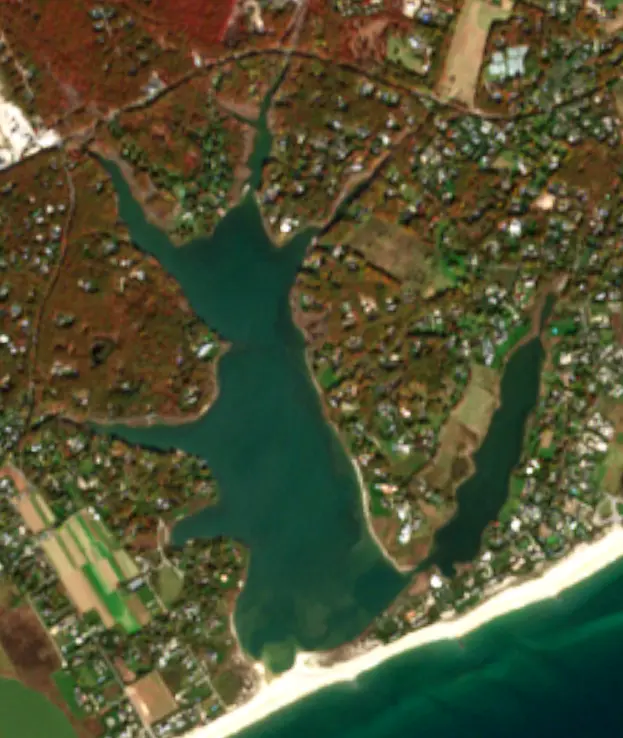
Georgica Pond is a coastal salt pond on the South Fork of Long Island, on the line between East Hampton Village and Wainscott in the Town of East Hampton. Only a narrow sand barrier separates it from the Atlantic Ocean. Large estates line its shores, and it is known for its blue crabs, the centuries-old custom of cutting it open to the sea, and a long fight against toxic algae.
The pond has a main body and six narrow coves that reach north into the land: Georgica Cove, Eel Creek, Goose Creek, Talmage Creek, Seabury Creek and Jones Creek. Small streams and groundwater feed the northern end. There is no lasting outlet, so the pond's character depends on whether the barrier beach is open or closed. When the sandbar stays shut for a long time, fresh water builds up and the pond can become close to fresh. When it is open to the ocean for a while, the water approaches the saltiness of the sea. That swing supports a varied community of fish, crabs and other animals, including one of the most productive blue crab fisheries on Long Island. Piping plovers nest on the sand nearby.
The East Hampton Town Trustees manage the pond by periodically digging a channel, known as the cut, through the sandbar to the ocean. The custom is older than the town itself. The Indigenous people of East Hampton opened the pond before colonial times, using clam shells as tools. Today the Trustees do the work to get tides moving between ocean and pond, which raises salinity and oxygen and lets fish and other animals move in and out. The 2023 spring cut was made in March. Moving sand closes the cut again on its own, sometimes within days and sometimes after months. Openings in the late 1980s and 1990s also relieved flooding around the pond.
The cut can change the pond fast. When Stony Brook University scientists measured the water before and after an opening in 2025, they recorded a dramatic jump in salinity.
The pond's algae problem came to wide attention in 2012, when a dog died suddenly on the shore and the state health department found cells resembling toxic cyanobacteria in its stomach. Christopher Gobler's lab at Stony Brook has studied the pond for the Trustees since 2013. In 2014 a bloom of blue-green algae lasted from mid-July into October and vanished within days after the Trustees opened the cut on October 15. The pond was closed to crabbing that year.
In 2015 the cut was held open for much of the first half of the year, but streams and groundwater pushed the salinity from 31 in late June to below 14 by early August, fresh enough for the algae. A dense bloom formed, levels topped 100 micrograms per liter against the state's notice threshold of 25, and on August 11 the Trustees closed the pond to crabbing for 21 days. The lab has also tied the pond's troubles to low oxygen and fish kills. Blooms above the state threshold were still recorded in 2025. During a bloom, the state warns against any contact with the water.
The estates around the pond have drawn well-known owners. Steven Spielberg, Ronald Perelman and developer Harry Macklowe have had homes on the pond, and Martha Stewart and Calvin Klein lived there earlier. The Grey Gardens estate is here too. In 1998 and 1999, President Bill Clinton stayed at the Spielberg house, making the area his summer White House.
Written by Lake by Lake from Gobler Laboratory, Stony Brook University (Georgica Pond, Blue-green algae bloom in Georgica Pond (August 2015)), East Hampton Town Trustees (Georgica Pond Spring Cut 2023, 2025 Water Quality Study, Final Report), The East Hampton Star and Wikipedia. Checked November 2026.
Where the level comes from: GEORGICA POND NEAR APAQUOQUE NY (U.S. Geological Survey).
| Lake | Miles | Level (ft) | vs full | 7 days |
|---|---|---|---|---|
| Laurel Lake Live reading | 18 | 5.22 | — | 0.00 |
| Scituate Reservoir Live reading | 65 | 280.35 | — | +0.23 |
| Lake Lillinonah Slightly below full | 66 | 196.79 | −3.21 | +1.59 |
| Hempstead Lake Live reading | 77 | 20.65 | — | — |
| Baisley Pond Live reading | 84 | 5.66 | — | +0.01 |
| Little Long Pond Live reading | 91 | 53.64 | — | −0.12 |
Compare Georgica Pond with Laurel Lake, Scituate Reservoir, Lake Lillinonah or Hempstead Lake: size, level, ramps and fish side by side.
Georgica Pond is about 45 mi from New Haven, CT, 54 mi from Bridgeport, CT and 60 mi from Waterbury, CT. See all the lakes near each city.
Georgica Pond is at 3.83 feet above sea level, as of Nov 13, 2026, 5:45 AM EST. It has risen 0.40 ft in the past 7 days.
Georgica Pond has 1 boat ramp on our map. Low water can close ramps, so check today's level above and the operator before you go.
Yes. There is 1 campground within about a mile of the shore, such as Hampton Country Day Camp.
Anglers 16 and older need a New York fishing license, sold online by the New York State Department of Environmental Conservation. Free fishing days: Presidents’ Day weekend, a weekend in late June, National Hunting and Fishing Day (September) and Veterans Day. Size and bag limits can be set lake by lake: check the current regulations.
boating (1 boat ramp), hiking & walking (1 trail along the shore, the longest East Hampton To Sag Harbor Trail (6.0 mi)), camping (1 campground), cabins & lodging (1 place to stay close to the water) and waterfront dining (1 waterfront restaurant), according to our map of the shore.
EPA's CyAN satellite rated cyanobacteria in Georgica Pond not detected on November 9. The satellite sees open water only; blooms can be patchy, so avoid water that looks like spilled paint or pea soup and keep dogs out of scum. Swimming advisories come from New York health and environment agencies.
Yes. A trail runs along or near the shore, including East Hampton To Sag Harbor Trail (6.0 mi), according to OpenStreetMap.
From the U.S. Geological Survey (GEORGICA POND NEAR APAQUOQUE NY). Lake by Lake checks it every hour; the agency's own figure is always the reference, and provisional readings can be revised.
Lake levels are refreshed every hour. Texas and California reservoirs report once a day; most USGS and NOAA gauges report every 15 to 60 minutes.
Cookies for analytics With your OK we use Google Analytics and Microsoft Clarity to count visits and see how the site is used, so we can make it better. No advertising cookies. Privacy policy