Sun
- Sunrise
- 7:13 AM
- Sunset
- 5:27 PM
- First light
- 6:46 AM
- Last light
- 5:54 PM
Reservoir · Clay County, North Carolina
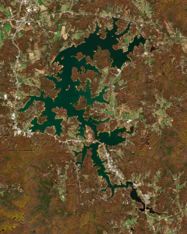
A reservoir on the Hiwassee River in Clay County, North Carolina, held back by Chatuge Dam since 1942.

Chatuge Lake is at 1,918.31 feet above sea level — 7.69 ft below summer pool, as of Nov 19, 2026, 4:00 AM EST. It has dropped 0.30 ft in the past 7 days.
3rd lowest of 8 North Carolina lakes today against full pool · See the ranking
A notification from this browser, once, when the level crosses the line (checked every hour). No account and no email. On an iPhone, add Lake by Lake to your home screen first (Share → Add to Home Screen) and open it from there. Or follow the lake in a feed reader: RSS feed.
Chatuge Lake is down 0.30 ft over the last 7 days, at 1,918.31 ft today.
Daily values from the NOAA National Water Prediction Service.
Chatuge Lake is down 0.84 ft over the last 30 days, at 1,918.31 ft today.
Daily values from the NOAA National Water Prediction Service. Why lake levels rise and fall
Solunar periods for Chatuge Lake, local time. How they work
Moderate · as of Nov 9, 2026
A bloom may be forming somewhere on the lake. Avoid water that looks like spilled paint or pea soup. About 143,000 cells/mL at the worst spot, covering less than 1% of the lake.
Week of Aug 16Week of Nov 1
Each bar is one week, colored by the worst reading of that week.
From the U.S. EPA's Cyanobacteria Assessment Network (CyAN), which reads the color of lakes from the Sentinel-3 satellites; it sees open water only, not coves or the shoreline. Blooms can be patchy: what you see on the water matters more. Swimming closures and health advisories come from North Carolina health and environment agencies. How to read it
Surface water temperature
64°F on Nov 7, 2026
83°F · Jul 2664°F · Nov 7
19°F cooler than on Jul 26, 2026.
Estimated from Landsat 8/9 (USGS) passes on clear days: the top layer of the water, a few degrees either way. Coves and the shallows can be warmer.
Chatuge Lake water temperature: trend, swimming and the fish →
On or near the shore of Chatuge Lake: 8 boat ramps, 4 marinas, 1 rental outfit, 16 campgrounds, 3 beaches and 7 trails. The lake has about 110 miles of shoreline, counting its islands.
Tap an icon for details; use two fingers (or Ctrl + scroll) to move the map. Tap a dot for details. Map and lake outline © OpenStreetMap contributors. Places from OpenStreetMap, Overture Maps and Recreation.gov. Not for navigation.
What you’ll find on the shore
← AllBoating 12
← AllRentals & tours 1
← AllFishing spots 2
← AllBeaches 3
← AllCamping 16
← AllLodging 24+
← AllTrails 7
← AllParks 8
← AllDining 18
These invasive plants and animals have been recorded in Chatuge Lake: clean, drain and dry everything before you go to another lake.
North Carolina: North Carolina has no clean-drain-dry law for boaters. The Wildlife Resources Commission urges you to clean off plants, animals and mud, drain all water, dry your gear, and never move fish or plants from one water to another. State rules
Records: USGS Nonindigenous Aquatic Species database. A species not listed may still be present.
Species with open-licensed records inside Chatuge Lake's outline, from GBIF.org (surveys, museum collections and angler reports). A record shows a fish was found here, not how many there are now.
Shallow, protected flats in spring; docks, grass and deep edges in summer heat.
Brush piles, docks and bridge pilings; shallow for a few weeks in spring.
Channel edges and river arms; best after dark in summer, and after a rain.
Rocky points, gravel and current breaks; deeper rock piles in summer.
Rocky shorelines and riprap at night in late winter; deep weed edges and humps in summer.
Water temperature sets off each spawn; the bars show the usual months at this latitude and elevation, and move with a warm or cold spring. The water is about 64°F now.
Chatuge Lake is a Tennessee Valley Authority reservoir on the upper Hiwassee River, straddling the state line between Hayesville in Clay County, North Carolina, and Hiawassee in Towns County, Georgia. Parts of its shore lie in the Nantahala and Chattahoochee national forests, and it is often called the highest major lake in Georgia.
TVA picked the farm valley south of Hayesville in 1940, and the project became part of the World War II push for electricity to make aluminum. The agency formally approved it on July 17, 1941, timing the work so crews could move over from the nearly finished Hiwassee Dam downstream. The payroll peaked at about 2,200 workers at the end of 1941, and the dam closed on February 12, 1942. Unlike most TVA dams of the period, Chatuge was built only to store water, releasing it to the power plants below. It got a rolled earth dam and a concrete spillway but no generator, which was not judged worth the cost at the time. A single generating unit was approved in 1951 and went into commercial service on December 9, 1954. Below the dam the Hiwassee flows north and west through North Carolina to meet the Tennessee River in Meigs County, Tennessee.
The project takes its name from an 18th-century Cherokee settlement near the dam site. The name is often said to refer to the meeting of waters, here the Hiwassee and Shooting Creek.
The valley held some of the best farmland in the area, with corn, hay and tobacco fields, dairies and cattle, hog and sheep farms. People in Clay and Towns counties worried about losing that land and the taxes it paid, and TVA answered with annual payments to the counties in place of property taxes. TVA acquired 11,462 acres, a little over half of it in North Carolina. It moved 278 families, all year-round residents, along with schools, churches, about 40 miles of road and 20 cemeteries holding 2,199 graves. On Cemetery Island, about 30 graves of the Old Burch Cemetery were left in place at the families' request.
The lake reaches about 13 miles south up the Hiwassee into Georgia and about 6 miles east along Shooting Creek. TVA runs it on a seasonal curve: lowest around mid-February, when flood risk peaks, and highest around Memorial Day, with a swing of roughly 10 feet in a normal year. In 2025 TVA began an environmental review of repairs or a new spillway after finding the old spillway's chute slab in poor condition. Each construction option it studied would hold the lake as much as 10 feet below normal winter level for several years during construction.
Jackrabbit Mountain Recreation Area, run by the Forest Service on a peninsula on the North Carolina side, has a campground, a summer swimming beach, a boat ramp and about 14 miles of trails open to mountain bikes. Near the dam TVA built a picnic area with a boat ramp and the Gibson Cove campground with a small beach. In Hiawassee the Georgia Mountain Fairgrounds runs a year-round lakeside campground, holds the Georgia Mountain Fair each August and keeps the Hamilton Rhododendron Gardens. Clay County shoots its Fourth of July fireworks over the water.
Walleye were first stocked by North Carolina and Georgia in the early 1960s and held on for decades, until blueback herring showed up in 1996 and the walleye disappeared. North Carolina began stocking about 30,000 fingerlings a year in 2014 at the Shooting Creek Public Fishing Area, and by 2016 Georgia's fall nets were catching plump, well-fed walleye again. Spotted, largemouth and smallmouth bass, hybrid striped bass, crappie, bluegill and catfish fill out the catch, and bass clubs hold tournaments here.
Written by Lake by Lake from National Park Service, National Register of Historic Places, Tennessee Valley Authority (Federal Register notice), North Carolina Wildlife Resources Commission, Recreation.gov, National Forests in North Carolina, Georgia Mountain Fair, Inc. and Wikipedia. Checked November 2026.
Chatuge Dam is an earthfill dam 144 feet high and 2,850 feet long on the Hiwassee River, completed in 1942. It belongs to the Tennessee Valley Authority and is run for flood control, recreation, hydropower and water supply. At its normal level the reservoir holds 226,600 acre-ft, drained from 189 square miles of land.
From the National Inventory of Dams (U.S. Army Corps of Engineers), NID ID NC00391. Lake or reservoir: what’s the difference?
Where the level comes from: Hiwassee River above Chatuge Dam near Hayesville (NOAA National Water Prediction Service).
| Lake | Miles | Level (ft) | vs full | 7 days |
|---|---|---|---|---|
| Mission Lake At or near full pool | 8 | 99.49* | −0.51 | −0.01 |
| Nantahala Lake Well below full | 15 | 82.47* | −17.53 | +1.30 |
| Lake Nottely Below full | 17 | 1762.34 | −14.66 | −0.62 |
| Queens Creek Lake Well below full | 19 | 84.05* | −15.95 | −5.62 |
| Lake Burton At or near full pool | 21 | 1864.70 | −1.90 | −0.24 |
| Hiwassee Lake Well below full | 24 | 1488.01 | −32.99 | −1.37 |
* Local gauge datum: 100 ft = full pond (Duke Energy lakes).
Compare Chatuge Lake with Mission Lake, Nantahala Lake, Lake Nottely or Queens Creek Lake: size, level, ramps and fish side by side.
Chatuge Lake is at 1,918.31 feet above sea level — 7.69 ft below summer pool, as of Nov 19, 2026, 4:00 AM EST. It has dropped 0.30 ft in the past 7 days.
Chatuge Lake's summer pool is 1,926.00 ft, according to Tennessee Valley Authority. Today the lake is 7.69 ft below that mark.
Chatuge Lake has 8 boat ramps on our map, including Boat ramp near Gibson Cove Campground, Boat ramp near Lake Chatuge Recreation Area, Chatuge Cove Marina, and 4 marinas. Low water can close ramps, so check today's level above and the operator before you go.
Yes. There are 16 campgrounds and RV parks within about a mile of the shore, such as Jackrabbit Mountain Campground, Jack Rabbit Campground, Penland Point Campground.
Game fish recorded in Chatuge Lake include spotted bass, largemouth bass, bluegill, white bass, channel catfish, black crappie. In all, 25 fish species have open records inside the lake on GBIF.
The surface of Chatuge Lake was about 64°F on November 7, estimated from a satellite pass on a clear day. It is the top layer of the water, a few degrees either way; coves and shallows run warmer in the sun.
Anglers 16 and older need a North Carolina fishing license, sold online by the North Carolina Wildlife Resources Commission. Free fishing days: July 4. Size and bag limits can be set lake by lake: check the current regulations.
Chatuge Lake averages about 34 ft deep. Depth changes with the lake level.
In summer a white Secchi disk lowered into Chatuge Lake stays visible to about 10.0 ft (the median of 47 readings, 2016–2025, by Georgia DNR Environmental Protection Division and North Carolina Dept of Environmental Quality NCDEQ-DWR WQX): clear water. With the algae measured too (chlorophyll about 5 µg/L), that makes it mesotrophic: moderately rich in nutrients. Clarity drops after storms and during algae blooms.
boating (8 boat ramps and 4 marinas), kayaks, boats & jet skis (1 rental outfit on or near the water), fishing (19 game fish), swimming (3 beaches and swimming areas), hiking & walking (7 trails along the shore, the longest Rabbit Ridge Trail (4.5 mi)) and camping (16 campgrounds, 1 bookable on Recreation.gov), according to our map of the shore.
EPA's CyAN satellite rated cyanobacteria in Chatuge Lake moderate on November 9. The satellite sees open water only; blooms can be patchy, so avoid water that looks like spilled paint or pea soup and keep dogs out of scum. Swimming advisories come from North Carolina health and environment agencies.
Yes. 7 trails run along or near the shore, including Jackrabbit Mountain Trail (2.0 mi), Central Loop (3.1 mi) and Sneaking Creek Trail (2.7 mi), according to OpenStreetMap.
Chatuge Lake is held back by Chatuge Dam, completed in 1942 and 144 ft high, according to the National Inventory of Dams.
From the NOAA National Water Prediction Service (Hiwassee River above Chatuge Dam near Hayesville). Lake by Lake checks it every hour; the agency's own figure is always the reference, and provisional readings can be revised.
Lake levels are refreshed every hour. Texas and California reservoirs report once a day; most USGS and NOAA gauges report every 15 to 60 minutes.
Cookies for analytics With your OK we use Google Analytics and Microsoft Clarity to count visits and see how the site is used, so we can make it better. No advertising cookies. Privacy policy




