Sun
- Sunrise
- 6:55 AM
- Sunset
- 5:12 PM
- First light
- 6:28 AM
- Last light
- 5:39 PM
Reservoir · McCurtain County, Oklahoma
A reservoir on the Mountain Fork River in McCurtain County, Oklahoma, held back by Broken Bow Dam since 1968. Also called Broken Bow Reservoir.

Broken Bow Lake is at 589.43 feet above sea level — 10.07 ft below normal pool, as of Nov 18, 2026, 11:00 PM CST. It has dropped 0.44 ft in the past 7 days.
3rd lowest of 37 Oklahoma lakes today against full pool · See the ranking
Record low 586.69 ft (2014), record high 628.34 ft (2015) · Level history since 2014
A notification from this browser, once, when the level crosses the line (checked every hour). No account and no email. On an iPhone, add Lake by Lake to your home screen first (Share → Add to Home Screen) and open it from there. Or follow the lake in a feed reader: RSS feed.
Broken Bow Lake is down 0.44 ft over the last 7 days, at 589.43 ft today.
Daily values from the U.S. Army Corps of Engineers.
Broken Bow Lake is down 1.81 ft over the last 30 days, at 589.43 ft today.
Daily values from the U.S. Army Corps of Engineers.
Over the past 12 months, Broken Bow Lake ranged from 589.29 ft (Feb 2, 2026) to 605.72 ft (Jun 25, 2026), a swing of 16.4 ft. Today's level is near the bottom of that range. It is 3.05 ft lower than on this date last year.
Daily values from the U.S. Army Corps of Engineers. Why lake levels rise and fall
In the U.S. Army Corps of Engineers record, which starts in 2014, the lowest level was 586.69 ft on December 27, 2014 and the highest 628.34 ft on May 25, 2015. Today’s 589.43 ft is 2.7 ft above the record low and 38.9 ft below the record high.
Broken Bow Lake level history: every year since 2014, the lowest and highest years →
Solunar periods for Broken Bow Lake, local time. How they work
Moderate · as of Nov 9, 2026
A bloom may be forming somewhere on the lake. Avoid water that looks like spilled paint or pea soup. About 194,000 cells/mL at the worst spot, covering 8% of the lake.
Week of Aug 16Week of Nov 1
Each bar is one week, colored by the worst reading of that week.
From the U.S. EPA's Cyanobacteria Assessment Network (CyAN), which reads the color of lakes from the Sentinel-3 satellites; it sees open water only, not coves or the shoreline. Blooms can be patchy: what you see on the water matters more. Swimming closures and health advisories come from Oklahoma health and environment agencies. How to read it
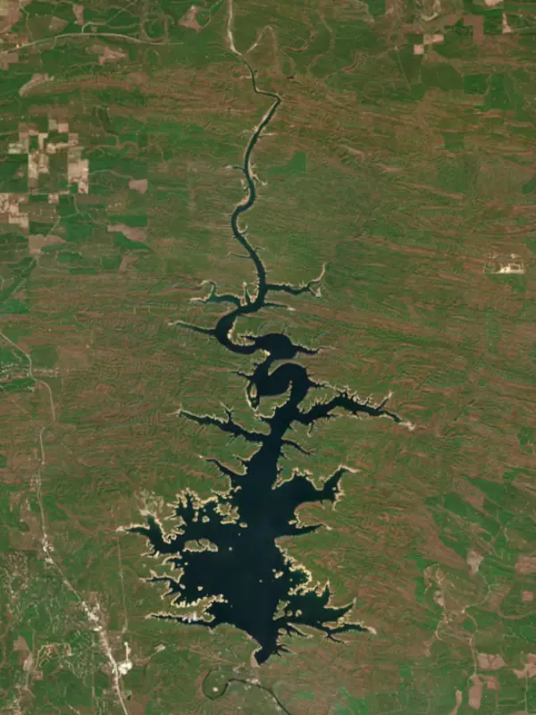
Surface water temperature
72°F on Nov 1, 2026
74°F · Jul 2872°F · Nov 1
2°F cooler than on Jul 28, 2026.
Estimated from Landsat 8/9 (USGS) passes on clear days: the top layer of the water, a few degrees either way. Coves and the shallows can be warmer.
Broken Bow Lake water temperature: trend, swimming and the fish →
On or near the shore of Broken Bow Lake: 5 boat ramps, 1 marina, 3 rental outfits, 1 campground, 2 beaches, 4 trails and 1 fishing guide. The lake has about 220 miles of shoreline, counting its islands.
Tap an icon for details; use two fingers (or Ctrl + scroll) to move the map. Tap a dot for details. Map and lake outline © OpenStreetMap contributors. Places from OpenStreetMap, Overture Maps and Recreation.gov. Not for navigation.
What you’ll find on the shore
← AllBoating 6
← AllRentals & tours 3
← AllFishing spots 5
← AllBeaches 2
← AllCamping 1
← AllLodging 20
← AllTrails 4
← AllParks 7
← AllDining 1
No aquatic invasive species are on record for Broken Bow Lake in the USGS database. Keep it that way: clean, drain and dry your boat between lakes.
Oklahoma: Before launching, remove all aquatic plants and zebra or quagga mussels from your boat, trailer and gear (state law); moving aquatic plants between waters is also illegal. Draining, and drying for five days if you can't hot-wash, are recommended but not required. State rules
Records: USGS Nonindigenous Aquatic Species database. A species not listed may still be present.
Species with open-licensed records inside Broken Bow Lake's outline, from GBIF.org (surveys, museum collections and angler reports). A record shows a fish was found here, not how many there are now.
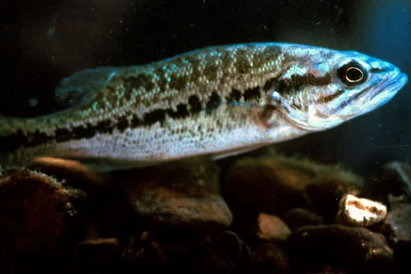
Shallow, protected flats in spring; docks, grass and deep edges in summer heat.
Rocky points, gravel and current breaks; deeper rock piles in summer.
Clear water and steep rock; they often suspend deeper than largemouth.
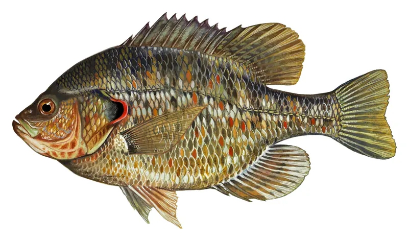
Beds in shallow, firm bottoms; around docks and weeds all summer.
On the bottom near snail beds; spawns around the full moon.
Water temperature sets off each spawn; the bars show the usual months at this latitude and elevation, and move with a warm or cold spring.
Broken Bow Lake is an Army Corps of Engineers reservoir on the Mountain Fork River in McCurtain County, in the far southeastern corner of Oklahoma, about 9 miles northeast of the town of Broken Bow. It winds some 22 miles back into the pine-covered Ouachita Mountains, and with Beavers Bend State Park on its shore and a year-round trout stream below the dam, it draws visitors from across Oklahoma and from neighboring Texas and Arkansas.
This was Choctaw country. Choctaw families settled around Hochatown in the early 1830s, and the area became part of Bok Tuklo County in the Apukshunnubbee District of the Choctaw Nation. The timber came next. Herman and Fred Dierks, lumbermen from Broken Bow, Nebraska, founded the Choctaw Lumber Company and named their mill town after their old home. Broken Bow was incorporated in 1911, and the Dierks holdings, including what was then one of the largest lumber mills in the nation, were sold to Weyerhaeuser in 1969.
The old town of Hochatown grew up around the same lumber company, got a post office in 1894 and was a busy place by 1900. When the best timber ran out in the 1920s and 1930s, it became better known for moonshine. The Flood Control Act of 1958 authorized a dam on the Mountain Fork, and construction began in October 1961. Hochatown's post office closed in 1963 and the last family left in 1966. The church and cemetery were moved to higher ground, the other buildings were torn down, and the site now lies under more than 200 feet of water. Water began rising behind the dam in October 1968, the first hydropower unit came on line in January 1970, and the lake reached its normal level that April. A new Hochatown grew up about a mile west of the lake along U.S. 259 and incorporated as a town in 2022.
Beavers Bend State Park, named for John T. Beavers, a Choctaw citizen by marriage, covers 3,482 acres along the lakeshore and the river below the dam. Cabins, campsites and two yurts sit in the woods, and people come to hike, boat, canoe and float the river. The park and its lake draw more than a million visitors a year.
Farther up the Mountain Fork, the McCurtain County Wilderness Area protects about 14,000 acres of what the state historical society describes as the country's last large tract of never-logged shortleaf pine and hardwood forest, home to the endangered red-cockaded woodpecker. The state set it aside in 1918, and the National Park Service named it a National Natural Landmark in 1975. The Department of Wildlife Conservation limits public access.
Below the dam, the Lower Mountain Fork is one of only two trout fisheries in Oklahoma stocked all year. Rainbows are stocked most often, and the Lower Mountain Fork is also one of the few places where the state stocks brown trout. The park has two catch-and-release trophy areas. Fly anglers fish hatches of caddis, midges and mayflies through the year, with big Hexagenia mayflies on the water in summer. Hot weather is the fishery's weak spot. High stream temperatures and low oxygen can halt stocking in summer, and the state asks for water releases from the dam to keep the fishery going.
Written by Lake by Lake from Oklahoma Historical Society, Encyclopedia of Oklahoma History and Culture (Broken Bow, McCurtain County Wilderness Area), Oklahoma Department of Wildlife Conservation, Oklahoma Tourism and Recreation Department, TravelOK and Wikipedia (Broken Bow Lake, Hochatown, Oklahoma). Checked November 2026.
Activities listed by the U.S. Army Corps of Engineers: Boating · Camping · Fishing · Hiking · Picnicking · Water sports · Wildlife viewing
Broken Bow Dam is a concrete gravity dam 225 feet high and 4,026 feet long on the Mountain Fork River, completed in 1968. It belongs to the U.S. Army Corps of Engineers (Tulsa District) and is run for flood control, recreation, hydropower and water supply. At its normal level the reservoir holds 918,070 acre-ft, drained from 754 square miles of land.
From the National Inventory of Dams (U.S. Army Corps of Engineers), NID ID OK10307. Lake or reservoir: what’s the difference?
Where the level comes from: Broken Bow Lake (U.S. Army Corps of Engineers).
| Lake | Miles | Level (ft) | vs full | 7 days |
|---|---|---|---|---|
| Hugo Lake Slightly below full | 40 | 400.09 | −4.41 | −0.12 |
| Sardis Lake At or near full pool | 51 | 597.02 | −1.98 | −0.17 |
| Millwood Lake At or near full pool | 52 | 259.12 | −0.08 | −0.11 |
| Pat Mayse Lake Slightly below full | 53 | 448.21 | −2.79 | +0.04 |
| Wister Lake Slightly below full | 55 | 473.44 | −4.56 | −0.28 |
| Lake Greeson Well below full | 56 | 532.94 | −15.06 | −0.07 |
Compare Broken Bow Lake with Hugo Lake, Sardis Lake, Millwood Lake or Pat Mayse Lake: size, level, ramps and fish side by side.
Broken Bow Lake is also known as Broken Bow Reservoir.
Broken Bow Lake is at 589.43 feet above sea level — 10.07 ft below normal pool, as of Nov 18, 2026, 11:00 PM CST. It has dropped 0.44 ft in the past 7 days.
Broken Bow Lake's normal pool is 599.50 ft, according to U.S. Army Corps of Engineers. Today the lake is 10.07 ft below that mark.
Today's level is 3.92 ft below the median for this date (593.35 ft), from the gauge’s long-term daily record.
586.69 ft, on December 27, 2014, in the U.S. Army Corps of Engineers record, which starts in 2014. Today the lake is 2.7 ft above that.
628.34 ft, on May 25, 2015, in the U.S. Army Corps of Engineers record since 2014. That is 28.8 ft above normal pool.
Broken Bow Lake has 5 boat ramps on our map, including Beavers Bend Marina Boat Ramp, McCurtain Co. Wilderness Area Boat Ramp, Boat ramp near Carson Creek Recreation Area, and 1 marina. Low water can close ramps, so check today's level above and the operator before you go.
Yes. There is 1 campground within about a mile of the shore, such as Beavers Bend Land And Water Park.
Game fish recorded in Broken Bow Lake include largemouth bass, smallmouth bass, spotted bass, bluegill, redear sunfish, green sunfish. In all, 31 fish species have open records inside the lake on GBIF.
Anglers 18 and older need an Oklahoma fishing license, sold online by the Oklahoma Department of Wildlife Conservation. Free fishing days: First weekend in June. Size and bag limits can be set lake by lake: check the current regulations.
Broken Bow Lake averages about 45 ft deep. Depth changes with the lake level.
In summer a white Secchi disk lowered into Broken Bow Lake stays visible to the bottom, over 8.5 ft (the median of 17 readings, 2016–2023, by OWRB Lakes Monitoring): clear water. With the algae measured too (chlorophyll about 4 µg/L), that makes it mesotrophic: moderately rich in nutrients. Clarity drops after storms and during algae blooms.
U.S. Army Corps of Engineers lists boating, camping, fishing, hiking, picnicking, water sports and wildlife viewing at Broken Bow Lake.
EPA's CyAN satellite rated cyanobacteria in Broken Bow Lake moderate on November 9. The satellite sees open water only; blooms can be patchy, so avoid water that looks like spilled paint or pea soup and keep dogs out of scum. Swimming advisories come from Oklahoma health and environment agencies.
Yes. 4 trails run along or near the shore, including Lakeview Lodge Trail (3.9 mi), Indian Nations Trail (0.8 mi) and Beaver Lodge Nature Trail (0.9 mi), according to OpenStreetMap.
Broken Bow Lake is held back by Broken Bow Dam, completed in 1968 and 225 ft high, according to the National Inventory of Dams.
From the U.S. Army Corps of Engineers (Broken Bow Lake). Lake by Lake checks it every hour; the agency's own figure is always the reference, and provisional readings can be revised.
Lake levels are refreshed every hour. Texas and California reservoirs report once a day; most USGS and NOAA gauges report every 15 to 60 minutes.
Cookies for analytics With your OK we use Google Analytics and Microsoft Clarity to count visits and see how the site is used, so we can make it better. No advertising cookies. Privacy policy