Sun
- Sunrise
- 7:03 AM
- Sunset
- 4:42 PM
- First light
- 6:32 AM
- Last light
- 5:13 PM
Lake · Klamath County, Oregon
A lake in Klamath County, Oregon.

Crater Lake is at 6,165.09 feet above sea level, as of Nov 17, 2026, 6:30 PM PST. It has dropped 0.15 ft in the past 7 days.
2nd lowest of 9 Oregon lakes today against normal for the date · See the ranking
Record low 6,165.07 ft (2026), record high 6,174.20 ft (2017) · Level history since 2009
A notification from this browser, once, when the level crosses the line (checked every hour). No account and no email. On an iPhone, add Lake by Lake to your home screen first (Share → Add to Home Screen) and open it from there. Or follow the lake in a feed reader: RSS feed.
Crater Lake is down 0.57 ft over the last 30 days, at 6,165.09 ft today.
Daily values from the U.S. Geological Survey.
Over the past 12 months, Crater Lake ranged from 6,165.07 ft (Nov 12, 2026) to 6,167.90 ft (Apr 22, 2026), a swing of 2.8 ft. Today's level is near the bottom of that range. It is 2.00 ft lower than on this date last year.
Daily values from the U.S. Geological Survey. Why lake levels rise and fall
In the U.S. Geological Survey record, which starts in 2009, the lowest level was 6,165.07 ft on November 12, 2026 and the highest 6,174.20 ft on June 12, 2017. Today’s 6,165.09 ft is 0.0 ft above the record low and 9.1 ft below the record high.
Crater Lake level history: every year since 2009, the lowest and highest years →
Solunar periods for Crater Lake, local time. How they work
Low · as of Nov 7, 2026
Some cyanobacteria at the surface, under 100,000 cells/mL. About 78,000 cells/mL at the worst spot, covering 1% of the lake.
Week of Aug 16Week of Nov 1
Each bar is one week, colored by the worst reading of that week.
From the U.S. EPA's Cyanobacteria Assessment Network (CyAN), which reads the color of lakes from the Sentinel-3 satellites; it sees open water only, not coves or the shoreline. Blooms can be patchy: what you see on the water matters more. Swimming closures and health advisories come from Oregon health and environment agencies. How to read it
Surface water temperature
45°F on Nov 10, 2026
62°F · Jul 2745°F · Nov 10
18°F cooler than on Jul 27, 2026.
Estimated from MODIS Aqua (NASA) passes on clear days: the top layer of the water, a few degrees either way. Coves and the shallows can be warmer.
Crater Lake water temperature: trend, swimming and the fish →
On or near the shore of Crater Lake: 1 campground and 7 trails. The lake has about 25 miles of shoreline, counting its islands.
Tap an icon for details; use two fingers (or Ctrl + scroll) to move the map. Tap a dot for details. Map and lake outline © OpenStreetMap contributors. Places from OpenStreetMap, Overture Maps and Recreation.gov. Not for navigation.
No aquatic invasive species are on record for Crater Lake in the USGS database. Keep it that way: clean, drain and dry your boat between lakes.
Oregon: All boaters, paddlers included, must stop at open boat inspection stations. After leaving the water, pull the drain plug and drain all water-holding areas before trailering; releasing live bait, fish or plants into a waterbody is illegal. Required: Waterway Access Permit (paddlecraft); Out-of-State AIS Permit (motorboats) (Paddlecraft $6 for 7 days, $20 a year or $35 for 2 years; out-of-state motorboats $30 a year). State rules
Records: USGS Nonindigenous Aquatic Species database. A species not listed may still be present.
Species with open-licensed records inside Crater Lake's outline, from GBIF.org (surveys, museum collections and angler reports). A record shows a fish was found here, not how many there are now.
Schools at a set depth in summer: trolling at the right depth is everything.
Water temperature sets off each spawn; the bars show the usual months at this latitude and elevation, and move with a warm or cold spring. The water is about 45°F now.
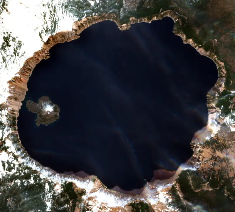
Crater Lake fills the collapsed summit of Mount Mazama, a volcano in the Cascade Range of Oregon, and is the heart of Crater Lake National Park. It is the deepest lake in the United States, and its deep blue color and clear water have drawn admirers for generations.
Mount Mazama once stood about 12,000 feet tall. About 7,700 years ago a massive eruption, followed by more eruptions along fractures circling the mountain, weakened it until the summit collapsed into a caldera 5 to 6 miles across. New vents soon began building Wizard Island, and over several hundred years rain and snow partly filled the basin. The last eruption, on the east side of Wizard Island, came about 4,800 years ago.
No river or stream feeds the lake. It gets only rain and snow, and the park averages more than 40 feet of snow a year, though less than in the 1930s. Evaporation and seepage through porous rock on the north shore remove about as much water as falls, so the level changes little. The great volume of water holds enough heat that the lake rarely freezes, and it has not frozen over since 1949. Water this pure absorbs every color but blue, and the lake's clarity averages about 100 feet. Research dives in a small submarine from 1987 to 1989 found warm water seeping up through the bottom, with mats of bacteria living off its iron.
Sandals and other artifacts buried under Mazama's ash show that people camped here before the eruption. The Klamath, descendants of the Makalak people, tell of it as a battle between Llao, chief of the Below World, standing on Mount Mazama, and Skell, chief of the Above World, standing on Mount Shasta. When it ended the mountain had fallen in on Llao, and rain filled the hole. The Makalaks held the place so sacred that looking at it was thought to bring death, and some Native Americans still choose not to view the lake.
On June 12, 1853, three members of a gold-hunting party out of Jacksonville stumbled on it and proposed the name Deep Blue Lake, but the find was soon forgotten. Later parties named it Blue Lake and Lake Majesty, and in 1869 Jacksonville newspaper editor Jim Sutton, after boating out to Wizard Island, wrote it up as Crater Lake. William Gladstone Steel, who read about the lake in 1870 and first saw it in 1885, spent 17 years pushing to protect it, and Crater Lake National Park was created on May 22, 1902.
The only way down to the water is the Cleetwood Cove Trail, 1.1 miles each way with a drop of about 700 feet on loose pumice. It is usually open from late June through October. Boat tours leave from the cove, and Wizard Island can be reached only on a scheduled boat. Swimming is allowed only at Cleetwood Cove, where wetsuits, floats and boats are not permitted, and even in summer the surface water is only 55 to 60 degrees. Out on the lake floats the Old Man of the Lake, a 30-foot mountain hemlock log with about 3 feet showing above the water, tracked since 1896.
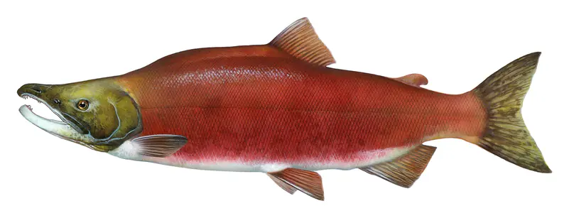
There is no evidence that fish ever lived here naturally. Seven species were stocked until 1941, and only rainbow trout and kokanee salmon survived. Anglers need no license and face no limits, but only artificial lures are allowed. Crayfish, brought in in 1915 as food for the fish, have spread along much of the shore and now threaten the Mazama newt, a form of rough-skinned newt found only here.
Written by Lake by Lake from National Park Service, Crater Lake National Park (Crater Lake, Frequently Asked Questions, History and Culture, Crater Lake History (park brochure), Fishing). Checked November 2026.
Activities listed by the National Park Service: Scenic drives · Biking · Boating · Climbing · Camping · Fishing · Hiking · Picnicking · Water sports · Wildlife viewing · Paddling · Swimming
Where the level comes from: CRATER LAKE NEAR CRATER LAKE, OR (U.S. Geological Survey).
| Lake | Miles | Level (ft) | vs full | 7 days |
|---|---|---|---|---|
| Diamond Lake Live reading | 15 | 5183.57 | — | −0.01 |
| Lemolo Lake Live reading | 25 | 4123.79 | — | −0.15 |
| Lost Creek Lake Well below full | 36 | 1777.10 | −94.90 | −0.80 |
| Fourmile Lake Live reading | 37 | 5726.06 | — | 0.00 |
| Crescent Lake Well below full | 37 | 4825.53 | −21.47 | +0.03 |
| Fish Lake Well below full | 43 | 4626.00 | −15.50 | +0.36 |
Compare Crater Lake with Diamond Lake, Lemolo Lake, Lost Creek Lake or Fourmile Lake: size, level, ramps and fish side by side.
Crater Lake is at 6,165.09 feet above sea level, as of Nov 17, 2026, 6:30 PM PST. It has dropped 0.15 ft in the past 7 days.
Today's level is 8.30 ft below the median for this date (6,173.39 ft), from the gauge’s long-term daily record.
6,165.07 ft, on November 12, 2026, in the U.S. Geological Survey record, which starts in 2009. Today the lake is 0.0 ft above that.
6,174.20 ft, on June 12, 2017, in the U.S. Geological Survey record since 2009.
Yes. There is 1 campground within about a mile of the shore, such as Mazama Village Campground.
Game fish recorded in Crater Lake include kokanee salmon. In all, 1 fish species have open records inside the lake on GBIF.
The surface of Crater Lake was about 45°F on November 10, estimated from a satellite pass on a clear day. It is the top layer of the water, a few degrees either way; coves and shallows run warmer in the sun.
Anglers 12 and older need an Oregon fishing license, sold online by the Oregon Department of Fish and Wildlife. Free fishing days: Presidents' Day weekend, one weekend in June, and Thanksgiving weekend. Size and bag limits can be set lake by lake: check the current regulations.
Crater Lake is about 1,949 ft deep at its deepest point, and about 1,148 ft deep on average. Depth changes with the lake level.
Yes: bathymetric map with depth contours from the U.S. Geological Survey (2001). It is linked in the lake facts on this page. Depths on a map are measured at a reference level: subtract how far the lake is below it today.
National Park Service lists scenic drives, biking, boating, climbing, camping, fishing, hiking and picnicking at Crater Lake National Park.
EPA's CyAN satellite rated cyanobacteria in Crater Lake low on November 7. The satellite sees open water only; blooms can be patchy, so avoid water that looks like spilled paint or pea soup and keep dogs out of scum. Swimming advisories come from Oregon health and environment agencies.
Yes. 7 trails run along or near the shore, including Fumarole Bay Trail (0.7 mi), Wizard Island Summit Trail (1.1 mi) and Cleetwood Cove Trail (1.0 mi), according to OpenStreetMap.
From the U.S. Geological Survey (CRATER LAKE NEAR CRATER LAKE, OR). Lake by Lake checks it every hour; the agency's own figure is always the reference, and provisional readings can be revised.
Lake levels are refreshed every hour. Texas and California reservoirs report once a day; most USGS and NOAA gauges report every 15 to 60 minutes.