Sun
- Sunrise
- 6:54 AM
- Sunset
- 4:36 PM
- First light
- 6:24 AM
- Last light
- 5:06 PM
Lake · Lake County, Oregon
A lake fed by the Chewaucan River in Lake County, Oregon.

Lake Abert is at 4,251.68 feet above sea level, as of Nov 17, 2026, 6:45 PM PST. It has risen 0.14 ft in the past 7 days.
5th highest of 9 Oregon lakes today against normal for the date · See the ranking
Record low 4,250.79 ft (2023), record high 4,255.30 ft (2025) · Level history since 2023
A notification from this browser, once, when the level crosses the line (checked every hour). No account and no email. On an iPhone, add Lake by Lake to your home screen first (Share → Add to Home Screen) and open it from there. Or follow the lake in a feed reader: RSS feed.
Lake Abert has held steady over the last 30 days (within 0.05 ft).
Daily values from the U.S. Geological Survey.
Over the past 310 days, Lake Abert ranged from 4,251.53 ft (Nov 9, 2026) to 4,254.32 ft (Mar 5, 2026), a swing of 2.8 ft. Today's level is near the bottom of that range. It is 1.73 ft lower than on this date last year.
Daily values from the U.S. Geological Survey. Why lake levels rise and fall
In the U.S. Geological Survey record, which starts in 2023, the lowest level was 4,250.79 ft on October 15, 2023 and the highest 4,255.30 ft on June 1, 2025. Today’s 4,251.68 ft is 0.9 ft above the record low and 3.6 ft below the record high.
Lake Abert level history: every year since 2023, the lowest and highest years →
Solunar periods for Lake Abert, local time. How they work
Not detected · as of Nov 9, 2026
The satellite found no cyanobacteria at the surface.
Week of Aug 16Week of Nov 1
Each bar is one week, colored by the worst reading of that week.
From the U.S. EPA's Cyanobacteria Assessment Network (CyAN), which reads the color of lakes from the Sentinel-3 satellites; it sees open water only, not coves or the shoreline. Blooms can be patchy: what you see on the water matters more. Swimming closures and health advisories come from Oregon health and environment agencies. How to read it
What you’ll find on the shore
No aquatic invasive species are on record for Lake Abert in the USGS database. Keep it that way: clean, drain and dry your boat between lakes.
Oregon: All boaters, paddlers included, must stop at open boat inspection stations. After leaving the water, pull the drain plug and drain all water-holding areas before trailering; releasing live bait, fish or plants into a waterbody is illegal. Required: Waterway Access Permit (paddlecraft); Out-of-State AIS Permit (motorboats) (Paddlecraft $6 for 7 days, $20 a year or $35 for 2 years; out-of-state motorboats $30 a year). State rules
Records: USGS Nonindigenous Aquatic Species database. A species not listed may still be present.
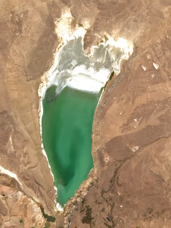
Lake Abert is a broad, shallow salt lake in the high desert of Lake County, Oregon, about 30 miles north of Lakeview. It has no outlet, it is too salty and alkaline for fish, and it lies at the foot of Abert Rim, a fault scarp that rises more than 2,000 feet above the water. Most people know it from the long drive along its east shore on U.S. Highway 395.
At the end of the last ice age, a much larger lake called Lake Chewaucan filled this basin. As the climate dried, starting roughly 12,000 years ago, it shrank and split, leaving Lake Abert and Summer Lake, now about 20 miles apart, with the salts concentrated in what remained. Mineral crusts still coat boulders as much as 300 feet above today's shore. People lived along this shore long before any written record, and the sites they left on the east side make up the East Lake Abert Archeological District. The Northern Paiute name for the lake means bad, undrinkable water. A Hudson's Bay Company trapping party under John Work wrote it down as a salt lake in October 1832. In December 1843 John C. Frémont named it for Colonel John James Abert, head of the Army's Corps of Topographical Engineers.
The rim is a west-facing fault that tilts gently away to the east on top. Salt-desert shrub grows at its base, with mountain mahogany, juniper and aspen on the face and ponderosa pine along the top. The Bureau of Land Management manages the lake and the land around it, including the Lake Abert Area of Critical Environmental Concern and the Abert Rim Wilderness Study Area, which runs about 21 miles along the escarpment. Highway 395 follows the east shore, and the small community of Valley Falls lies about 3 miles to the southwest. The rim also draws nesting raptors. There are no developed facilities. Bird watching is the main thing to do, some people paddle kayaks, and dispersed camping is allowed. Swimming or long contact with the strongly alkaline water is harmful.
The water is too salty for fish, but it grows staggering numbers of brine shrimp and alkali flies, and those feed the birds of the Pacific Flyway. Wilson's phalaropes can arrive by the hundreds of thousands in midsummer, and eared grebes, red-necked phalaropes, American avocets and gulls gather in large numbers too. It is also one of the few inland places in Oregon where snowy plovers nest. A small commercial harvest of brine shrimp began in 1979.
The lake depends almost entirely on the Chewaucan River, which comes down from the south past Paisley. Farms divert water from it, mostly between Paisley and the lake, and the water rights on paper add up to more than the river carries in an average year. In 2014, after a decade of moderate drought, hot weather and continued diversions, Lake Abert shrank to about 5 percent of its full size and its salinity more than tripled. The brine shrimp and flies collapsed, far fewer grebes and phalaropes stopped to feed, and life in the lake came to be dominated by salt-loving microbes. Researchers found the last comparable collapse was during the Dust Bowl of the 1930s. A study using 25 years of bird counts found sightings fell by as much as 82 percent in low, salty years, and the brine shrimp business closed after 35 years. Oregon's conservation strategy now calls for measuring stream flows and for a shared effort to meet the lake's water needs. Spring and fall migration are the times to see it working as it should.
Written by Lake by Lake from Bureau of Land Management, Oregon Department of Fish and Wildlife, Oregon Conservation Strategy, Western North American Naturalist (Larson et al., 2016), National Audubon Society and Wikipedia. Checked November 2026.
Activities listed by the Bureau of Land Management: Biking · Fishing · Hiking · Picnicking · Wildlife viewing · Photography · Paddling · Swimming · Canoeing
Where the level comes from: LAKE ABERT NEAR VALLEY FALLS, OR (U.S. Geological Survey).
| Lake | Miles | Level (ft) | vs full | 7 days |
|---|---|---|---|---|
| Drews Reservoir Live reading | 40 | 4895.63 | — | — |
| Gerber Reservoir Well below full | 56 | 4815.15 | −20.25 | +0.04 |
| Upper Klamath Lake Live reading | 87 | 4140.68 | — | +0.01 |
Compare Lake Abert with Drews Reservoir, Gerber Reservoir or Upper Klamath Lake: size, level, ramps and fish side by side.
Lake Abert is at 4,251.68 feet above sea level, as of Nov 17, 2026, 6:45 PM PST. It has risen 0.14 ft in the past 7 days.
Today's level is 0.46 ft below the median for this date (4,252.14 ft), from the gauge’s long-term daily record.
4,250.79 ft, on October 15, 2023, in the U.S. Geological Survey record, which starts in 2023. Today the lake is 0.9 ft above that.
4,255.30 ft, on June 1, 2025, in the U.S. Geological Survey record since 2023.
Anglers 12 and older need an Oregon fishing license, sold online by the Oregon Department of Fish and Wildlife. Free fishing days: Presidents' Day weekend, one weekend in June, and Thanksgiving weekend. Size and bag limits can be set lake by lake: check the current regulations.
Lake Abert averages about 99 ft deep. Depth changes with the lake level.
Yes: atlas lake page with bathymetric map from the Portland State University, Atlas of Oregon Lakes (1985). It is linked in the lake facts on this page. Depths on a map are measured at a reference level: subtract how far the lake is below it today.
Bureau of Land Management lists biking, fishing, hiking, picnicking, wildlife viewing, photography, paddling and swimming at Lake Abert and Abert Rim.
EPA's CyAN satellite rated cyanobacteria in Lake Abert not detected on November 9. The satellite sees open water only; blooms can be patchy, so avoid water that looks like spilled paint or pea soup and keep dogs out of scum. Swimming advisories come from Oregon health and environment agencies.
From the U.S. Geological Survey (LAKE ABERT NEAR VALLEY FALLS, OR). Lake by Lake checks it every hour; the agency's own figure is always the reference, and provisional readings can be revised.
Lake levels are refreshed every hour. Texas and California reservoirs report once a day; most USGS and NOAA gauges report every 15 to 60 minutes.