Sun
- Sunrise
- 7:00 AM
- Sunset
- 4:43 PM
- First light
- 6:30 AM
- Last light
- 5:13 PM
Reservoir · Klamath County, Oregon
A reservoir on the Klamath River in Klamath County, Oregon, held back by Link River Diversion Dam since 1921.

Upper Klamath Lake is at 4,140.68 feet above sea level, as of Nov 17, 2026, 6:30 PM PST. The level has held steady over the past week.
4th highest of 9 Oregon lakes today against normal for the date · See the ranking
Record low 4,140.08 ft (2016), record high 4,145.28 ft (2019) · Level history since 2016
A notification from this browser, once, when the level crosses the line (checked every hour). No account and no email. On an iPhone, add Lake by Lake to your home screen first (Share → Add to Home Screen) and open it from there. Or follow the lake in a feed reader: RSS feed.
Upper Klamath Lake is up 0.05 ft over the last 30 days, at 4,140.68 ft today.
Daily values from the U.S. Geological Survey.
Over the past 12 months, Upper Klamath Lake ranged from 4,140.62 ft (Oct 19, 2026) to 4,144.62 ft (Apr 5, 2026), a swing of 4.0 ft. Today's level is near the bottom of that range. It is 0.90 ft lower than on this date last year.
Daily values from the U.S. Geological Survey. Why lake levels rise and fall
In the U.S. Geological Survey record, which starts in 2016, the lowest level was 4,140.08 ft on October 13, 2016 and the highest 4,145.28 ft on May 6, 2019. Today’s 4,140.68 ft is 0.6 ft above the record low and 4.6 ft below the record high.
Upper Klamath Lake level history: every year since 2016, the lowest and highest years →
Solunar periods for Upper Klamath Lake, local time. How they work
Stay away from algae and scum, and keep dogs out of the water near them.
From the Oregon Health Authority, checked Nov 16. Advisories change with the weather: check the agency's page and the signs at the water before you go.
High · as of Nov 9, 2026
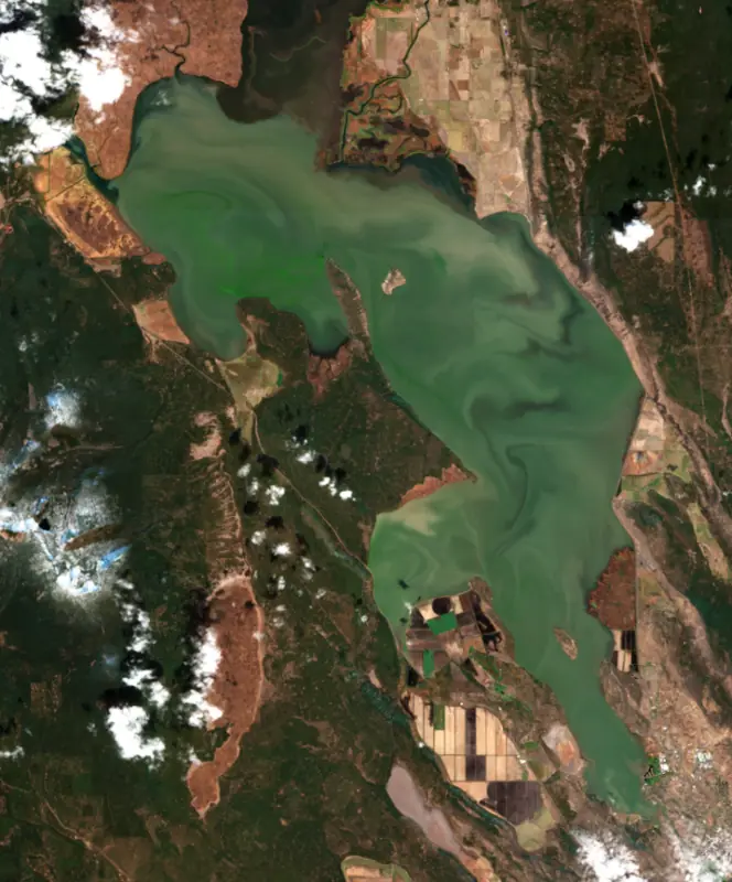
The satellite sees a likely bloom on part of the lake. Avoid discolored water and scum, and keep dogs out of it. About 586,000 cells/mL at the worst spot, covering 22% of the lake.
Week of Aug 16Week of Nov 1
Each bar is one week, colored by the worst reading of that week.
From the U.S. EPA's Cyanobacteria Assessment Network (CyAN), which reads the color of lakes from the Sentinel-3 satellites; it sees open water only, not coves or the shoreline. Blooms can be patchy: what you see on the water matters more. Swimming closures and health advisories come from Oregon health and environment agencies. How to read it
Surface water temperature
45°F on Nov 10, 2026
77°F · Jul 2745°F · Nov 10
32°F cooler than on Jul 27, 2026.
Estimated from MODIS Aqua (NASA) passes on clear days: the top layer of the water, a few degrees either way. Coves and the shallows can be warmer.
Upper Klamath Lake water temperature: trend, swimming and the fish →
On or near the shore of Upper Klamath Lake: 7 boat ramps, 1 marina, 3 campgrounds and 5 trails. The lake has about 102 miles of shoreline, counting its islands.
Tap an icon for details; use two fingers (or Ctrl + scroll) to move the map. Tap a dot for details. Map and lake outline © OpenStreetMap contributors. Places from OpenStreetMap, Overture Maps and Recreation.gov. Not for navigation.
What you’ll find on the shore
← AllBoating 8
← AllFishing spots 1
← AllCamping 3
← AllLodging 3
← AllTrails 5
← AllParks 6
← AllDining 3
These invasive plants and animals have been recorded in Upper Klamath Lake: clean, drain and dry everything before you go to another lake.
Oregon: All boaters, paddlers included, must stop at open boat inspection stations. After leaving the water, pull the drain plug and drain all water-holding areas before trailering; releasing live bait, fish or plants into a waterbody is illegal. Required: Waterway Access Permit (paddlecraft); Out-of-State AIS Permit (motorboats) (Paddlecraft $6 for 7 days, $20 a year or $35 for 2 years; out-of-state motorboats $30 a year). State rules
Records: USGS Nonindigenous Aquatic Species database. A species not listed may still be present.
Species with open-licensed records inside Upper Klamath Lake's outline, from GBIF.org (surveys, museum collections and angler reports). A record shows a fish was found here, not how many there are now.
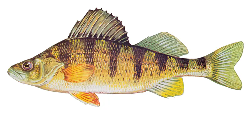
Cool water: near the surface in spring and fall, deep in summer.
Schools near the bottom; a favorite through the ice.
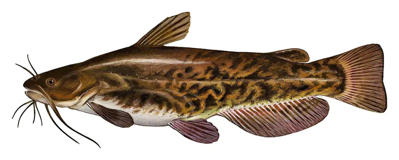
Soft, weedy bottoms in shallow bays; bites best after dark in late spring and summer.
Water temperature sets off each spawn; the bars show the usual months at this latitude and elevation, and move with a warm or cold spring. The water is about 45°F now.
Upper Klamath Lake is a broad, shallow natural lake in Klamath County, Oregon, east of the Cascade Range, with the city of Klamath Falls at its southern tip. It is what remains of a much larger ice-age lake, the main water supply of a federal irrigation project, and the home water of two endangered suckers that matter deeply to the Klamath Tribes.
The lake is the largest surviving piece of Lake Modoc, a pluvial lake that shrank away as the climate warmed and dried about 10,000 years ago. It runs about 25 miles from north to south. The Williamson and Wood rivers come in at the north end, where the lake joins the smaller Agency Lake. At the south end the water leaves through the short Link River, which runs past Klamath Falls into Lake Ewauna and becomes the Klamath River. The lake is rich in nutrients by nature, but farm runoff and the draining of the marshes around it have pushed it further, and blue-green algae blooms now appear every summer. By late May or early June the water quality turns poor enough that trout crowd into cold-water refuges, including the spring-fed creeks along its edges.
The Klamath Tribes have lived in this basin since long before memory, with settlements on Agency Lake, at the mouth of the lower Williamson River, on Pelican Bay and along the Link River. Peter Skene Ogden of the Hudson's Bay Company came through in 1826 and called it Dog Lake. In an 1864 treaty the tribes gave up more than 23 million acres but kept the right to hunt, fish and gather. Congress terminated their federal recognition in 1954 and the reservation land was lost, and recognition was restored in 1986 without the land. A federal court ruled in 1974 that the treaty rights had survived. Two fish in the lake carry special weight. The Lost River sucker is c'waam to the Klamath people and the shortnose sucker is koptu. Both were listed as endangered in 1988. Each spring the tribes hold the Return of the c'waam Ceremony on the Sprague River, at the place where they say the Creator first set out the tradition.
The Secretary of the Interior authorized the Klamath Project on May 15, 1905. Work began in 1906 on the main A Canal, and the first water reached farms on May 22, 1907. Under a 1917 contract, the California-Oregon Power Company built Link River Dam at the lake's outlet, finished in 1921, in return for the right to use it for power, and project farmers received preferential power rates, rights that have since expired. The lake has been regulated for irrigation since 1917, and the project now serves about 210,000 acres of cropland in Oregon and California. The dam is owned by the Bureau of Reclamation. In the drought of 2001, irrigation deliveries were halted to protect the suckers, which set off protests from farmers.
President Calvin Coolidge set aside the Upper Klamath refuge on April 3, 1928. It now takes in Hanks Marsh at the south end and a large marsh unit at the north end, and it is one of six refuges protecting what is left of what was once the largest wetland west of the Mississippi. A marked canoe trail winds through the northern marsh from the Rocky Point and Malone Springs launches, about 30 miles northwest of Klamath Falls below Mount McLoughlin. Paddlers often see otters, bald eagles, swans and herons, and May is good for migrating birds. The lake is known for native redband trout that feed in the lake and spawn in spring-fed tributaries. After record-low spawning counts in the winter of 2025-2026, Oregon made redband fishing on the lake and Pelican Bay catch-and-release only for the summer of 2026, so the state's current rules are worth checking before keeping a fish.
Written by Lake by Lake from The Klamath Tribes, Bureau of Reclamation, U.S. Fish and Wildlife Service (Upper Klamath National Wildlife Refuge, Serenity on the Water), Oregon Department of Fish and Wildlife and Wikipedia. Checked November 2026.
Activities listed by the Bureau of Reclamation: Boating · Fishing · Hunting · Wildlife viewing
Link River Diversion Dam is a concrete dam 22 feet high and 435 feet long on the Klamath River, completed in 1921. It belongs to the Bureau of Reclamation and is run for hydropower, irrigation and recreation. At its normal level the reservoir holds 735,000 acre-ft, drained from 3,800 square miles of land.
From the National Inventory of Dams (U.S. Army Corps of Engineers), NID ID OR00557. Lake or reservoir: what’s the difference?
Where the level comes from: UPPER KLAMATH LAKE NR K.FALLS(WEIGHT/MEAN ELEV) OR (U.S. Geological Survey).
| Lake | Miles | Level (ft) | vs full | 7 days |
|---|---|---|---|---|
| Keno Reservoir Live reading | 10 | 83.84 | — | −0.06 |
| Fourmile Lake Live reading | 26 | 5726.06 | — | 0.00 |
| Fish Lake Well below full | 29 | 4626.00 | −15.50 | +0.36 |
| Howard Prairie Lake Well below full | 29 | 4506.32 | −20.28 | −0.44 |
| Hyatt Reservoir Below full | 34 | 5001.13 | −14.87 | +0.08 |
| Gerber Reservoir Well below full | 35 | 4815.15 | −20.25 | +0.04 |
Compare Upper Klamath Lake with Keno Reservoir, Fourmile Lake, Fish Lake or Howard Prairie Lake: size, level, ramps and fish side by side.
Upper Klamath Lake is at 4,140.68 feet above sea level, as of Nov 17, 2026, 6:30 PM PST. The level has held steady over the past week.
Today's level is 0.23 ft below the median for this date (4,140.91 ft), from the gauge’s long-term daily record.
4,140.08 ft, on October 13, 2016, in the U.S. Geological Survey record, which starts in 2016. Today the lake is 0.6 ft above that.
4,145.28 ft, on May 6, 2019, in the U.S. Geological Survey record since 2016.
Upper Klamath Lake has 7 boat ramps on our map, including Moore Park Marina #1, Hagelstein Park, Rocky Point Public Boat Ramp, and 1 marina. Low water can close ramps, so check today's level above and the operator before you go.
Yes. There are 3 campgrounds and RV parks within about a mile of the shore, such as Eagle Ridge County Park, Odessa Creek Campground, Klamath Falls RV Resort by RJourney.
Game fish recorded in Upper Klamath Lake include rainbow trout, yellow perch, brown bullhead. In all, 15 fish species have open records inside the lake on GBIF.
The surface of Upper Klamath Lake was about 45°F on November 10, estimated from a satellite pass on a clear day. It is the top layer of the water, a few degrees either way; coves and shallows run warmer in the sun.
Anglers 12 and older need an Oregon fishing license, sold online by the Oregon Department of Fish and Wildlife. Free fishing days: Presidents' Day weekend, one weekend in June, and Thanksgiving weekend. Size and bag limits can be set lake by lake: check the current regulations.
Upper Klamath Lake is about 49 ft deep at its deepest point, usually near the dam, and about 9 ft deep on average. Depth changes with the lake level.
In summer a white Secchi disk lowered into Upper Klamath Lake stays visible to about 2.3 ft (the median of 216 readings, 2016–2018, by Klamath Tribes and Department of Environmental Quality - State of Oregon): murky water. With the algae measured too (chlorophyll about 86 µg/L), that makes it hypereutrophic: very rich in nutrients, prone to algae. Clarity drops after storms and during algae blooms.
Yes: atlas lake page with bathymetric map from the Portland State University, Atlas of Oregon Lakes. It is linked in the lake facts on this page. Depths on a map are measured at a reference level: subtract how far the lake is below it today.
Bureau of Reclamation lists boating, fishing, hunting and wildlife viewing at Upper Klamath Lake.
EPA's CyAN satellite rated cyanobacteria in Upper Klamath Lake high on November 9. The satellite sees open water only; blooms can be patchy, so avoid water that looks like spilled paint or pea soup and keep dogs out of scum. Swimming advisories come from Oregon health and environment agencies.
Yes. 5 trails run along or near the shore, including Link River Trail (1.3 mi), Sawmill Trail (0.6 mi) and Skillet Handle Trail (1.7 mi), according to OpenStreetMap.
Upper Klamath Lake is held back by Link River Diversion Dam, completed in 1921 and 22 ft high, according to the National Inventory of Dams.
From the U.S. Geological Survey (UPPER KLAMATH LAKE NR K.FALLS(WEIGHT/MEAN ELEV) OR). Lake by Lake checks it every hour; the agency's own figure is always the reference, and provisional readings can be revised.
Lake levels are refreshed every hour. Texas and California reservoirs report once a day; most USGS and NOAA gauges report every 15 to 60 minutes.