Sun
- Sunrise
- 7:05 AM
- Sunset
- 5:23 PM
- First light
- 6:38 AM
- Last light
- 5:50 PM
Reservoir · McCormick County, South Carolina
A reservoir fed by the Savannah River in McCormick County, South Carolina. Also called Clarks Hill Lake.

Lake Strom Thurmond is at 317.47 feet above sea level — 12.53 ft below full summer pool, as of Nov 19, 2026, 6:45 AM EST. It has dropped 0.33 ft in the past 7 days.
2nd lowest of 4 South Carolina lakes today against full pool · See the ranking
Record low 313.54 ft (2008), record high 335.97 ft (2016) · Level history since 2005
Which boat ramps are usable at today’s level →
A notification from this browser, once, when the level crosses the line (checked every hour). No account and no email. On an iPhone, add Lake by Lake to your home screen first (Share → Add to Home Screen) and open it from there. Or follow the lake in a feed reader: RSS feed.
Lake Strom Thurmond is down 0.33 ft over the last 7 days, at 317.47 ft today.
Daily values from the U.S. Geological Survey.
Lake Strom Thurmond is down 1.93 ft over the last 30 days, at 317.47 ft today.
Daily values from the U.S. Geological Survey.
Over the past 12 months, Lake Strom Thurmond ranged from 317.40 ft (Nov 18, 2026) to 325.51 ft (Nov 22, 2025), a swing of 8.1 ft. Today's level is near the bottom of that range. It is 7.74 ft lower than on this date last year.
Daily values from the U.S. Geological Survey. Why lake levels rise and fall
In the U.S. Geological Survey record, which starts in 2005, the lowest level was 313.54 ft on November 10, 2008 and the highest 335.97 ft on January 1, 2016. Today’s 317.47 ft is 3.9 ft above the record low and 18.5 ft below the record high.
Lake Strom Thurmond level history: every year since 2005, the lowest and highest years →
Solunar periods for Lake Strom Thurmond, local time. How they work
A bloom may be developing: look at the water before you go in and keep dogs away from scum.
From the South Carolina Department of Environmental Services, checked Nov 19. Advisories change with the weather: check the agency's page and the signs at the water before you go.
Low · as of Nov 9, 2026
Some cyanobacteria at the surface, under 100,000 cells/mL. About 37,000 cells/mL at the worst spot, covering less than 1% of the lake.
Week of Aug 9Week of Nov 1
Each bar is one week, colored by the worst reading of that week.
From the U.S. EPA's Cyanobacteria Assessment Network (CyAN), which reads the color of lakes from the Sentinel-3 satellites; it sees open water only, not coves or the shoreline. Blooms can be patchy: what you see on the water matters more. Swimming closures and health advisories come from South Carolina health and environment agencies. How to read it
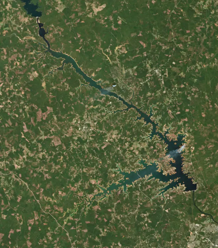
The last 11 satellite passes
85°F · Jul 2863°F · Nov 16
22°F cooler than on Jul 28, 2026.
Estimated from Landsat 8/9 (USGS) passes on clear days: the top layer of the water, a few degrees either way. Coves and the shallows can be warmer.
Lake Strom Thurmond water temperature: trend, swimming and the fish →
On or near the shore of Lake Strom Thurmond: 99 boat ramps, 9 marinas, 1 rental outfit, 37 campgrounds, 3 beaches, 1 fishing pier and 10 trails. The lake has about 1,026 miles of shoreline, counting its islands.
Tap an icon for details; use two fingers (or Ctrl + scroll) to move the map. Tap a dot for details. Map and lake outline © OpenStreetMap contributors. Places from OpenStreetMap, Overture Maps and Recreation.gov. Not for navigation.
What you’ll find on the shore
← AllBoating 108
Which boat ramps are usable at today’s level →
← AllRentals & tours 1
← AllFishing spots 7
← AllBeaches 3
← AllCamping 37
← AllLodging 11
← AllTrails 10
← AllParks 20+
← AllDining 5
These invasive plants and animals have been recorded in Lake Strom Thurmond: clean, drain and dry everything before you go to another lake.
South Carolina: South Carolina has no clean-drain-dry law for boats, but it is illegal to possess hydrilla, water hyacinth and other listed aquatic plants or put them in state waters, so strip off all plant fragments. Officials urge boaters to clean, drain and dry before moving to another lake. State rules
Records: USGS Nonindigenous Aquatic Species database. A species not listed may still be present.
Lake Strom Thurmond is the big Army Corps of Engineers reservoir on the Savannah River, on the line between Georgia and South Carolina above Augusta. South Carolina and the federal government call it by the senator's name, while Georgia still calls it Clarks Hill Lake. It is Georgia's largest reservoir, one of the most visited Corps lakes in the country, and a reliable lake for hybrid bass, crappie and catfish.
Congress authorized the project in the Flood Control Act of 1944, and the Corps began work in 1946. It was the first project the Corps built in the Savannah River basin. The lake filled in 1951 and 1952, and the project was finished in 1954, about 22 miles upstream of Augusta. It was built for power, flood control and navigation, and recreation, water supply, water quality, and fish and wildlife were added later. Together with Hartwell and Richard B. Russell upstream, it forms a chain of Corps lakes about 120 miles long.
The name has caused trouble from the start. The project took its name from the South Carolina town of Clarks Hill, but a clerical error in the authorization dropped the s and made it Clark Hill. Years later, legislation sponsored by Strom Thurmond restored Clarks Hill. Then in December 1987 Congress renamed the lake for Thurmond himself, without public comment, which angered many people on both sides of the river. Georgia answered in 1989 by making Clarks Hill the official state name, and its maps still use it.
The lake covers the site of Petersburg, a tobacco town founded in 1786 on the point of land where the Broad River meets the Savannah. At its peak around 1800 it was one of the largest towns in Georgia, with warehouses, taverns, a newspaper and a post office, and flat-bottomed boats poled hogsheads of tobacco about 60 miles downriver to Augusta. Rival towns stood within sight, Lisbon in Georgia and Vienna on the Carolina bank. When farmers turned from tobacco to cotton in the 1820s, and yellow fever struck, the town emptied out. By 1854 only three families were left. In the spring of 1865 Jefferson Davis and his cabinet crossed the Savannah just below the town while fleeing federal troops. The reservoir covered what remained in the early 1950s. The site is now the main historic draw at Bobby Brown Park in Elbert County, and in droughts the old town can be walked again.
The lake reaches about 39 miles up the Savannah, 29 miles up Georgia's Little River, 17 miles up South Carolina's Little River and a short way up the Broad. It touches McCormick County in South Carolina and Lincoln, Columbia, McDuffie and Wilkes counties in Georgia, with Lincolnton and McCormick among the towns closest to the water. Elijah Clark State Park near Lincolnton honors the Revolutionary War frontier leader and holds his grave and that of his wife, Hannah, along with a replica of the family's cabin. Mistletoe State Park lends fishing tackle and rents kayaks. On the Carolina side, Hickory Knob State Resort Park near McCormick has a lodge and an 18-hole golf course on the shore.
Blueback herring shape much of the fishing. Georgia biologists recommend drifting live bluebacks for hybrid and striped bass, and topwater lures for largemouth and spotted bass when the herring spawn in spring. Hybrids winter in Big and Soap creeks and the Little River arm and gather in summer near the mouths of the big creeks and around the lake's oxygen injection system. Crappie fishing is best on the upper lake, north of the U.S. 378 bridge, in Soap, Grays, Pistol and Newford creeks in spring. Channel, flathead and blue catfish are all established, and white perch are abundant.
Written by Lake by Lake from South Carolina Department of Natural Resources, Georgia Department of Natural Resources, Wildlife Resources Division, New Georgia Encyclopedia, Georgia State Parks, South Carolina State Parks and Wikipedia. Checked November 2026.
Activities listed by the U.S. Army Corps of Engineers: Biking · Boating · Camping · Fishing · Hiking · Horseback riding · Picnicking · Water sports · Wildlife viewing
Where the level comes from: THURMOND LAKE NEAR PLUM BRANCH, SC (U.S. Geological Survey).
| Lake | Miles | Level (ft) | vs full | 7 days |
|---|---|---|---|---|
| Richard B. Russell Lake At or near full pool | 24 | 473.09 | −1.91 | −0.30 |
| Butler Creek Reservoir Live reading | 32 | 27.42 | — | 0.00 |
| Lake Greenwood Live reading | 34 | 437.30 | — | −0.44 |
| Lake Hartwell Below full | 55 | 647.29 | −12.71 | −0.30 |
| Lake Oconee At or near full pool | 58 | 433.51 | −1.49 | +0.07 |
| Parr Reservoir Live reading | 65 | 262.31 | — | −1.03 |
Compare Lake Strom Thurmond with Richard B. Russell Lake, Butler Creek Reservoir, Lake Greenwood or Lake Hartwell: size, level, ramps and fish side by side.
Lake Strom Thurmond is about 36 mi from Augusta, GA and 59 mi from Athens, GA. See all the lakes near each city.
Lake Strom Thurmond is also known as Clarks Hill Lake.
Lake Strom Thurmond is at 317.47 feet above sea level — 12.53 ft below full summer pool, as of Nov 19, 2026, 6:45 AM EST. It has dropped 0.33 ft in the past 7 days.
Lake Strom Thurmond's full summer pool is 330.00 ft, according to U.S. Army Corps of Engineers. Today the lake is 12.53 ft below that mark.
Today's level is 6.60 ft below the median for this date (324.07 ft), from the gauge’s long-term daily record.
313.54 ft, on November 10, 2008, in the U.S. Geological Survey record, which starts in 2005. Today the lake is 3.9 ft above that.
335.97 ft, on January 1, 2016, in the U.S. Geological Survey record since 2005. That is 6.0 ft above full summer pool.
Lake Strom Thurmond has 99 boat ramps on our map, including Amity RA, Big Hart Park, Big Hart Recreation Area, and 9 marinas. Low water can close ramps, so check today's level above and the operator before you go.
Yes. There are 37 campgrounds and RV parks within about a mile of the shore, such as Hickory Knob Campsite 22, Hester's Ferry Campground, Modoc Campground.
The water at Lake Strom Thurmond is 62°F, measured 55 min ago by the USGS sensor in the lake. Surface temperature changes through the day and with depth.
Anglers 16 and older need a South Carolina fishing license, sold online by the South Carolina Department of Natural Resources. Free fishing days: Memorial Day and July 4 (residents, freshwater only). Size and bag limits can be set lake by lake: check the current regulations.
Lake Strom Thurmond averages about 117 ft deep. Depth changes with the lake level.
In summer a white Secchi disk lowered into Lake Strom Thurmond stays visible to about 7.4 ft (the median of 225 readings, 2016–2026, by Georgia DNR Environmental Protection Division and South Carolina Department of Environmental Services): clear water. With the algae measured too (chlorophyll about 7 µg/L), that makes it mesotrophic: moderately rich in nutrients. Clarity drops after storms and during algae blooms.
U.S. Army Corps of Engineers lists biking, boating, camping, fishing, hiking, horseback riding, picnicking and water sports at J. Strom Thurmond Lake. 12 campgrounds can be booked on Recreation.gov.
EPA's CyAN satellite rated cyanobacteria in Lake Strom Thurmond low on November 9. The satellite sees open water only; blooms can be patchy, so avoid water that looks like spilled paint or pea soup and keep dogs out of scum. Swimming advisories come from South Carolina health and environment agencies.
Yes. 10 trails run along or near the shore, including Bartram Trail (8.5 mi), Rock Dam Trail (4.1 mi) and Campground Loop Trail (0.8 mi), according to OpenStreetMap.
From the U.S. Geological Survey (THURMOND LAKE NEAR PLUM BRANCH, SC). Lake by Lake checks it every hour; the agency's own figure is always the reference, and provisional readings can be revised.
Lake levels are refreshed every hour. Texas and California reservoirs report once a day; most USGS and NOAA gauges report every 15 to 60 minutes.
Cookies for analytics With your OK we use Google Analytics and Microsoft Clarity to count visits and see how the site is used, so we can make it better. No advertising cookies. Privacy policy