Sun
- Sunrise
- 6:29 AM
- Sunset
- 4:46 PM
- First light
- 6:02 AM
- Last light
- 5:13 PM
Reservoir · Hardin County, Tennessee
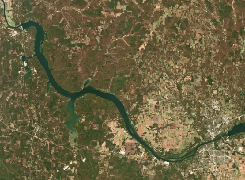
A reservoir on the Tennessee River in Hardin County, Tennessee, held back by Pickwick Landing Dam since 1938.

Pickwick Lake is at 409.96 feet above sea level — 4.04 ft below summer pool, as of Nov 17, 2026, 9:00 PM CST. It has dropped 0.43 ft in the past 7 days.
10th fullest of 23 Tennessee lakes today against full pool · See the ranking
A notification from this browser, once, when the level crosses the line (checked every hour). No account and no email. On an iPhone, add Lake by Lake to your home screen first (Share → Add to Home Screen) and open it from there. Or follow the lake in a feed reader: RSS feed.
Pickwick Lake is down 1.44 ft over the last 30 days, at 409.96 ft today.
Daily values from the Tennessee Valley Authority.
Over the past 12 months, Pickwick Lake ranged from 408.76 ft (Jan 25, 2026) to 416.26 ft (Jun 10, 2026), a swing of 7.5 ft. Today's level is near the bottom of that range. It is 0.17 ft lower than on this date last year.
Daily values from the Tennessee Valley Authority. Why lake levels rise and fall
Solunar periods for Pickwick Lake, local time. How they work
Moderate · as of Nov 9, 2026
A bloom may be forming somewhere on the lake. Avoid water that looks like spilled paint or pea soup. About 294,000 cells/mL at the worst spot, covering less than 1% of the lake.
Week of Aug 16Week of Nov 1
Each bar is one week, colored by the worst reading of that week.
From the U.S. EPA's Cyanobacteria Assessment Network (CyAN), which reads the color of lakes from the Sentinel-3 satellites; it sees open water only, not coves or the shoreline. Blooms can be patchy: what you see on the water matters more. Swimming closures and health advisories come from Tennessee health and environment agencies. How to read it
Surface water temperature
65°F on Nov 12, 2026
86°F · Jul 2965°F · Nov 12
21°F cooler than on Jul 29, 2026.
Estimated from Landsat 8/9 (USGS) passes on clear days: the top layer of the water, a few degrees either way. Coves and the shallows can be warmer.
Pickwick Lake water temperature: trend, swimming and the fish →
On or near the shore of Pickwick Lake: 22 boat ramps, 10 marinas, 2 rental outfits, 15 campgrounds, 5 beaches, 1 fishing pier and 10 trails. The lake has about 287 miles of shoreline, counting its islands.
Tap an icon for details; use two fingers (or Ctrl + scroll) to move the map. Tap a dot for details. Map and lake outline © OpenStreetMap contributors. Places from OpenStreetMap, Overture Maps and Recreation.gov. Not for navigation.
What you’ll find on the shore
← AllBoating 32
← AllRentals & tours 2
← AllFishing spots 8
← AllBeaches 5
← AllCamping 15
← AllLodging 18
← AllTrails 10
← AllParks 13
← AllDining 3
These invasive plants and animals have been recorded in Pickwick Lake: clean, drain and dry everything before you go to another lake.
Tennessee: Tennessee has no statewide clean-drain-dry law; TWRA urges you to remove plants, animals and mud, drain all water, and dry the boat for five days (or hot-wash it) before moving to another lake. Moving live invasive carp is illegal. State rules
Records: USGS Nonindigenous Aquatic Species database. A species not listed may still be present.
Species with open-licensed records inside Pickwick Lake's outline, from GBIF.org (surveys, museum collections and angler reports). A record shows a fish was found here, not how many there are now.
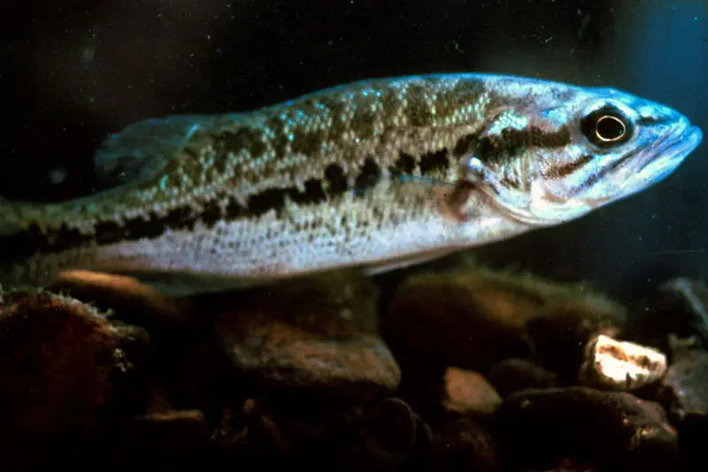
Shallow, protected flats in spring; docks, grass and deep edges in summer heat.
Channel edges and river arms; best after dark in summer, and after a rain.
Rocky points, gravel and current breaks; deeper rock piles in summer.
Run up the river arms in spring; follow shad to cool, deep water near the dam in summer.
Clear water and steep rock; they often suspend deeper than largemouth.
Water temperature sets off each spawn; the bars show the usual months at this latitude and elevation, and move with a warm or cold spring. The water is about 65°F now.
Pickwick Lake is the Tennessee Valley Authority reservoir on the Tennessee River where Tennessee, Mississippi and Alabama meet. It reaches 52.7 river miles from Pickwick Landing Dam near Counce, in Hardin County, Tennessee, up to the foot of Wilson Dam in the Shoals area of Alabama, and it is best known for smallmouth bass.
The landing beside the dam site was first called White Sulphur Springs. During the Civil War era its first postmaster renamed it after Charles Dickens' Pickwick Papers, and the dam took the name of that community. For a century before TVA, the rocky shoals upstream in Alabama were the great obstacle on the river. A canal around Muscle Shoals finished in 1836 proved useless at both low and high water, a revived canal project was completed in 1890, and during World War I the government turned to Wilson Dam to power two nitrate plants making explosives.
Congress created TVA on May 18, 1933, with a nine-foot navigation channel to Knoxville as one of its main goals. Pickwick was approved on November 19, 1934. It was the first dam designed by TVA's own staff and the third the agency built, after Norris and Wheeler, while Army engineers designed the lock. Work began on March 8, 1935, and the plant went into service on June 29, 1938.
TVA bought 62,000 acres in Hardin County, Tishomingo County in Mississippi, and Colbert and Lauderdale counties in Alabama. In 1935 the agency interviewed more than 700 rural families, about 500 of whom would be displaced. Most of them farmed, nearly half as tenants, and only eight of their homes had electricity. Some 67 miles of road were rebuilt, including four roads in Waterloo, Alabama, along with 13 bridges. The dam's Streamlined Moderne control building has changed little since it opened, though its marble lobby has been closed to visitors since 2001. A second, 1,000-foot lock opened in 1984, State Route 128 has crossed the dam since 1963, and the project was listed on the National Register of Historic Places in 2017.
Pickwick Landing State Resort Park, on the Tennessee shore in southern Hardin County, started as a TVA demonstration park. From 1935 to 1938 an African American Civilian Conservation Corps unit, Company 3459, which named itself Company Paul Lawrence Dunbar, built its trails, cabins, walls and shelters, though the park was opened to white visitors only. It later ran as a private resort before the state took it over. Today it has an inn, a marina, a golf course and three public swimming beaches, plus the Bruton Branch Primitive Area across the lake. On the Mississippi side, J.P. Coleman State Park sits on the lake, and the lake marks the northern end of the Tennessee-Tombigbee Waterway to the Gulf of Mexico.
Alabama's fisheries agency calls Pickwick the best place in the state for a black bass grand slam of largemouth, smallmouth and spotted bass, and several line-class records here have been certified by the International Game Fish Association. The prime water is the stretch called the Shoals, from just below Wilson Dam to the end of Seven-Mile Island, where releases through the turbines create a strong current that smallmouth favor. Bass bite best when TVA is generating, so anglers time their trips to the flow. In winter, sauger run up to the Wilson tailwater to spawn. Blue and channel catfish crowd the same water in summer, and crappie draw anglers into the Bear Creek and Second Creek embayments in spring. Milfoil and hydrilla grow in the lower lake, and weed edges and deep humps hold fish there. Because the lake lies in three states, licenses and size limits depend on where you are, and reciprocal agreements cover parts of it.
Written by Lake by Lake from National Park Service, National Register of Historic Places, Tennessee Encyclopedia, Alabama Department of Conservation and Natural Resources, Mississippi Department of Wildlife, Fisheries, and Parks and Wikipedia (Pickwick Lake, Pickwick Landing Dam). Checked November 2026.
Pickwick Landing Dam is a concrete dam 51 feet high and 7,715 feet long on the Tennessee River, completed in 1938. It belongs to the Tennessee Valley Authority and is run for flood control, navigation, recreation, hydropower and water supply. At its normal level the reservoir holds 1.11 million acre-ft, drained from 32,820 square miles of land.
From the National Inventory of Dams (U.S. Army Corps of Engineers), NID ID TN07101. Lake or reservoir: what’s the difference?
Where the level comes from: Pickwick Lake (Tennessee Valley Authority).
| Lake | Miles | Level (ft) | vs full | 7 days |
|---|---|---|---|---|
| Wilson Lake At or near full pool | 40 | 506.83 | −0.87 | −0.12 |
| Wheeler Lake Slightly below full | 53 | 552.38 | −3.62 | +0.16 |
Compare Pickwick Lake with Wilson Lake or Wheeler Lake: size, level, ramps and fish side by side.
Pickwick Lake is about 97 mi from Memphis, TN. See all the lakes near each city.
Pickwick Lake is at 409.96 feet above sea level — 4.04 ft below summer pool, as of Nov 17, 2026, 9:00 PM CST. It has dropped 0.43 ft in the past 7 days.
Pickwick Lake's summer pool is 414.00 ft, according to the Tennessee Valley Authority operating guide. Today the lake is 4.04 ft below that mark.
Pickwick Lake has 22 boat ramps on our map, including Boat ramp at Eastport Marina, Bruton Branch State Park, Colbert Ferry Boat Ramp, and 10 marinas. Low water can close ramps, so check today's level above and the operator before you go.
Yes. There are 15 campgrounds and RV parks within about a mile of the shore, such as Hart's RV Park, Cypress Shores Campground & RV Park, Second Creek Recreation Area.
Game fish recorded in Pickwick Lake include bluegill, sauger, smallmouth bass, largemouth bass, spotted bass, striped bass. In all, 40 fish species have open records inside the lake on GBIF.
The surface of Pickwick Lake was about 65°F on November 12, estimated from a satellite pass on a clear day. It is the top layer of the water, a few degrees either way; coves and shallows run warmer in the sun.
Anglers 13 and older need a Tennessee fishing license, sold online by the Tennessee Wildlife Resources Agency. Free fishing days: Free Fishing Day, one Saturday in June; children 15 and under fish free that whole week. Size and bag limits can be set lake by lake: check the current regulations.
Pickwick Lake averages about 26 ft deep. Depth changes with the lake level.
In summer a white Secchi disk lowered into Pickwick Lake stays visible to about 3.3 ft (the median of 33 readings, 2016–2023, by MISSISSIPPI DEPARTMENT OF ENVIRONMENTAL QUALITY and ALABAMA DEPT. OF ENVIRONMENTAL MANAGEMENT - WATER QUALITY DATA): somewhat murky water. With the algae measured too (chlorophyll about 11 µg/L), that makes it eutrophic: rich in nutrients, greener water. Clarity drops after storms and during algae blooms.
boating (22 boat ramps and 10 marinas), kayaks, boats & jet skis (2 rental outfits on or near the water), fishing (18 game fish and 1 fishing pier or spot), swimming (5 beaches and swimming areas), hiking & walking (10 trails along the shore, the longest TVA Nature Trail (2.7 mi)) and camping (15 campgrounds), according to our map of the shore.
EPA's CyAN satellite rated cyanobacteria in Pickwick Lake moderate on November 9. The satellite sees open water only; blooms can be patchy, so avoid water that looks like spilled paint or pea soup and keep dogs out of scum. Swimming advisories come from Tennessee health and environment agencies.
Yes. 10 trails run along or near the shore, including Rockpile Trail (2.5 mi), TVA Nature Trail (2.7 mi) and Island Loop Trail (1.8 mi), according to OpenStreetMap.
Pickwick Lake is held back by Pickwick Landing Dam, completed in 1938 and 51 ft high, according to the National Inventory of Dams.
From the Tennessee Valley Authority (Pickwick Lake). Lake by Lake checks it every hour; the agency's own figure is always the reference, and provisional readings can be revised.
Lake levels are refreshed every hour. Texas and California reservoirs report once a day; most USGS and NOAA gauges report every 15 to 60 minutes.