Sun
- Sunrise
- 6:58 AM
- Sunset
- 5:23 PM
- First light
- 6:32 AM
- Last light
- 5:49 PM
Reservoir · Collin County, Texas
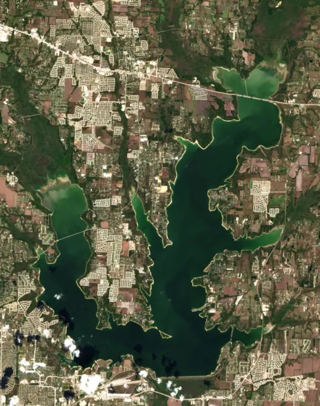
A reservoir on the East Fork of Trinity River in Collin County, Texas, held back by Lavon Dam since 1952.

Lavon Lake is at 487.42 feet above sea level — 4.58 ft below top of conservation pool, 78.0% full, as of Nov 17, 2026. The level has held steady over the past week. That is the lowest level since 2023.
55th lowest of 118 Texas lakes today by percent full · See the ranking
Record low 474.87 ft (2006), record high 504.57 ft (1990) · Level history since 1988
A notification from this browser, once, when the level crosses the line (checked every hour). No account and no email. On an iPhone, add Lake by Lake to your home screen first (Share → Add to Home Screen) and open it from there. Or follow the lake in a feed reader: RSS feed.
Lavon Lake is down 0.38 ft over the last 30 days, at 487.42 ft today.
Daily values from the Texas Water Development Board.
Over the past 12 months, Lavon Lake ranged from 487.42 ft (Nov 17, 2026) to 494.06 ft (Jun 22, 2026), a swing of 6.6 ft. Today's level is the lowest of the past 12 months. It is 1.27 ft lower than on this date last year.
Daily values from the Texas Water Development Board. Why lake levels rise and fall
In the Texas Water Development Board record, which starts in 1988, the lowest level was 474.87 ft on November 5, 2006 and the highest 504.57 ft on May 4, 1990. Today’s 487.42 ft is 12.6 ft above the record low and 17.1 ft below the record high. That is the lowest level since 2023.
Lavon Lake level history: every year since 1988, the lowest and highest years →
Solunar periods for Lavon Lake, local time. How they work
Not detected · as of Nov 9, 2026
The satellite found no cyanobacteria at the surface.
Week of Aug 16Week of Nov 1
Each bar is one week, colored by the worst reading of that week.
From the U.S. EPA's Cyanobacteria Assessment Network (CyAN), which reads the color of lakes from the Sentinel-3 satellites; it sees open water only, not coves or the shoreline. Blooms can be patchy: what you see on the water matters more. Swimming closures and health advisories come from Texas health and environment agencies. How to read it
Surface water temperature
67°F on Nov 13, 2026
88°F · Jul 1967°F · Nov 13
22°F cooler than on Jul 19, 2026.
Estimated from MODIS Aqua (NASA) passes on clear days: the top layer of the water, a few degrees either way. Coves and the shallows can be warmer.
Lavon Lake water temperature: trend, swimming and the fish →
On or near the shore of Lavon Lake: 22 boat ramps, 4 marinas, 1 rental outfit, 31 campgrounds, 1 fishing pier and 1 trail. The lake has about 98 miles of shoreline, counting its islands.
Tap an icon for details; use two fingers (or Ctrl + scroll) to move the map. Tap a dot for details. Map and lake outline © OpenStreetMap contributors. Places from OpenStreetMap, Overture Maps and Recreation.gov. Not for navigation.
What you’ll find on the shore
← AllBoating 26
← AllRentals & tours 1
← AllFishing spots 3
← AllCamping 31
← AllLodging 3
← AllTrails 1
← AllParks 17
← AllDining 4
Zebra mussels have been found in Lavon Lake. They clog intakes and engines and spread on boats and trailers: clean, drain and dry everything before you go to another lake.
Texas: Before leaving or arriving at any public fresh water, drain all water from the boat and gear, including bilge, livewells, motor and bait buckets; live bait bought from a dealer may stay in water if you carry the receipt. Remove any invasive plants clinging to the boat or trailer right away, and never move invasive species such as zebra mussels. State rules
Records: USGS Nonindigenous Aquatic Species database. A species not listed may still be present.
In the last 12 months, Texas Parks and Wildlife Department stocked 132,520 fish in Lavon Lake: Florida largemouth bass (132,520).
Source: Texas Parks and Wildlife Department stocking records.
Species with open-licensed records inside Lavon Lake's outline, from GBIF.org (surveys, museum collections and angler reports). A record shows a fish was found here, not how many there are now. marks fish the state stocks here.
Shallow, protected flats in spring; docks, grass and deep edges in summer heat.
Brush piles, docks and bridge pilings; shallow for a few weeks in spring.
Channel edges and river arms; best after dark in summer, and after a rain.
Rocky shorelines and riprap at night in late winter; deep weed edges and humps in summer.
Run up the river arms in spring; follow shad to cool, deep water near the dam in summer.
Water temperature sets off each spawn; the bars show the usual months at this latitude and elevation, and move with a warm or cold spring. The water is about 67°F now.
Lavon Lake is the Army Corps of Engineers reservoir on the East Fork of the Trinity River in Collin County, Texas, about 25 miles northeast of Dallas. For the cities north and east of Dallas it is two things at once: a source of drinking water and a big, close lake for crappie, catfish and a day at the beach.
Before the dam, the East Fork of the Trinity flooded the rich bottomland of southeastern Collin County season after season. Congress authorized a dam in 1945 for flood control and water conservation, and added recreation the next year. Work started in January 1948, and the lake was impounded in 1953. The North Texas Municipal Water District, formed in 1951, shared the cost in return for rights to part of the stored water, and today it can pump up to 350 million gallons a day from the lake. To hold more water supply, Congress approved a larger lake in 1962. Starting in 1970, crews raised the top of the dam 12 feet, lengthened the embankment and lifted the spillway, working on one half of the structure at a time behind steel cofferdams so the dam could stay in service. The higher pool, 20 feet above the old one, was ready in December 1975 and roughly doubled the size of the lake. The highest water since then came on May 3, 1990, when the Corps opened 12 spillway gates to release 54,000 cubic feet per second.
The lake has two main arms, the East Fork of the Trinity and the arm fed by Pilot Grove and Sister Grove creeks, with Princeton and Farmersville among the nearby towns. The dam sits about 3 miles east of Wylie, between Wylie and the town of Lavon, which dates from the 1850s and was named for the son of E.C. Thomson, a postmaster who kept the general store. The Corps runs more than a dozen parks around the shore with campgrounds, swimming beaches and boat ramps, and Caddo Park was built for visitors with disabilities. The Trinity Trail runs about 9 miles for riders and hikers between Brockdale Park and East Fork Park, and Sister Grove Park has a primitive hike-and-bike trail. Large tracts around the lake are kept as wildlife areas open to hunting. The land here was under a warm sea some 60 million years ago, and fossils of prehistoric reptiles have been found around the lake.
Texas Parks and Wildlife rates Lavon's crappie, blue catfish and sunfish fishing as excellent, and its largemouth bass, channel catfish and white bass as good. Crappie are the main draw, especially in winter and spring. Much of the fishing cover is standing timber left in the upper ends of the East Fork and Sister Grove arms, along with water willow and American lotus in the backs of coves. Blue catfish bite best in winter on deep, open points, white bass run up the creeks in spring, and in winter the warm outflow from the power plant on the east arm pulls in fish. The rock riprap along the dam holds bass, channel catfish and sunfish. The lake has its own catfish regulation, so check the current rules before keeping fish.
Zebra mussel DNA and larvae were first confirmed in Lavon in January 2014, five years after the mussels reached Lake Texoma to the north. Larvae have since been found more than once, and the state lists the lake as positive for the invader. Because the lake is a drinking-water supply, the rules matter here. Texas law requires boaters to drain all water from boats, livewells, bilges and motors before arriving at or leaving a lake, and possessing or moving zebra mussels is a crime.
Written by Lake by Lake from U.S. Army Corps of Engineers, Fort Worth District, Texas State Historical Association, Handbook of Texas, Texas Parks and Wildlife Department, Texas Invasives (Texas Parks and Wildlife Department and partners) and CBS News Texas. Checked November 2026.
Activities listed by the U.S. Army Corps of Engineers: Boating · Camping · Fishing · Hiking · Horseback riding · Picnicking · Water sports · Wildlife viewing
Lavon Dam is an earthfill dam 81 feet high and 19,493 feet long on the East Fork of Trinity River, completed in 1952. It belongs to the U.S. Army Corps of Engineers (Fort Worth District) and is run for flood control, fish and wildlife, recreation and water supply. At its normal level the reservoir holds 456,500 acre-ft, drained from 770 square miles of land.
From the National Inventory of Dams (U.S. Army Corps of Engineers), NID ID TX00007. Lake or reservoir: what’s the difference?
Where the level comes from: Lavon Lake (Texas Water Development Board, used on this page), Lavon Lk nr Lavon, TX (U.S. Geological Survey) and North Texas Lakes at Lake Lavon (NOAA National Water Prediction Service).
| Lake | Miles | Level (ft) | vs full | 7 days |
|---|---|---|---|---|
| Lake Ray Hubbard Slightly below full | 16 | 431.46 | −4.04 | −0.10 |
| New Terrell City Lake Well below full | 28 | 493.12 | −10.88 | −0.04 |
| Lewisville Lake Slightly below full | 28 | 517.82 | −4.18 | −0.02 |
| Grapevine Lake Slightly below full | 34 | 532.37 | −2.63 | +0.02 |
| Mountain Creek Lake At or near full pool | 34 | 457.74 | +0.74 | +0.19 |
| Lake Tawakoni Slightly below full | 36 | 434.35 | −3.15 | −0.19 |
Compare Lavon Lake with Lake Ray Hubbard, New Terrell City Lake, Lewisville Lake or Grapevine Lake: size, level, ramps and fish side by side.
Lavon Lake is about 12 mi from Garland, TX, 12 mi from Allen, TX and 14 mi from Richardson, TX. See all the lakes near each city.
Lavon Lake is at 487.42 feet above sea level — 4.58 ft below top of conservation pool, 78.0% full, as of Nov 17, 2026. The level has held steady over the past week. That is the lowest level since 2023.
Lavon Lake's top of conservation pool is 492.00 ft, according to Texas Water Development Board. Today the lake is 4.58 ft below that mark.
Today's level is 0.01 ft above the median for this date (487.41 ft), from the gauge’s long-term daily record.
474.87 ft, on November 5, 2006, in the Texas Water Development Board record, which starts in 1988. Today the lake is 12.6 ft above that.
504.57 ft, on May 4, 1990, in the Texas Water Development Board record since 1988. That is 12.6 ft above top of conservation pool.
Lavon Lake has 22 boat ramps on our map, including Boat ramp at Anchor Bay Marina, Boat ramp at East Fork Harbor Marina, Boat ramp at Lavon lake Highland park, and 4 marinas. Low water can close ramps, so check today's level above and the operator before you go.
Yes. There are 31 campgrounds and RV parks within about a mile of the shore, such as Clear Lake Campground, Lavonia RV Park Boat Dock, East Fork Campground.
Game fish recorded in Lavon Lake include largemouth bass, blue catfish, striped bass, white crappie, white bass, channel catfish. In all, 40 fish species have open records inside the lake on GBIF.
The surface of Lavon Lake was about 67°F on November 13, estimated from a satellite pass on a clear day. It is the top layer of the water, a few degrees either way; coves and shallows run warmer in the sun.
Anglers 17 and older need a Texas fishing license, sold online by the Texas Parks and Wildlife Department. Free fishing days: First Saturday in June. Size and bag limits can be set lake by lake: check the current regulations.
Lavon Lake averages about 21 ft deep. Depth changes with the lake level.
In summer a white Secchi disk lowered into Lavon Lake stays visible to about 1.0 ft (the median of 554 readings, 2016–2025, by Texas Commission on Environmental Quality): murky water. Silt after rain lowers the reading as much as algae do. Clarity drops after storms and during algae blooms.
Yes: hydrographic survey contour map from the Texas Water Development Board (2021). It is linked in the lake facts on this page. Depths on a map are measured at a reference level: subtract how far the lake is below it today.
U.S. Army Corps of Engineers lists boating, camping, fishing, hiking, horseback riding, picnicking, water sports and wildlife viewing at Lavon Lake. 3 campgrounds can be booked on Recreation.gov.
EPA's CyAN satellite rated cyanobacteria in Lavon Lake not detected on November 9. The satellite sees open water only; blooms can be patchy, so avoid water that looks like spilled paint or pea soup and keep dogs out of scum. Swimming advisories come from Texas health and environment agencies.
Yes. Texas Parks and Wildlife Department stocked Florida largemouth bass in Lavon Lake; the latest stocking on record was in 2026.
Yes. A trail runs along or near the shore, including Trinity Trail (20 mi), according to OpenStreetMap.
Lavon Lake is held back by Lavon Dam, completed in 1952 and 81 ft high, according to the National Inventory of Dams.
From the Texas Water Development Board (Lavon Lake). Lake by Lake checks it every hour; the agency's own figure is always the reference, and provisional readings can be revised.
Lake levels are refreshed every hour. Texas and California reservoirs report once a day; most USGS and NOAA gauges report every 15 to 60 minutes.




