Sun
- Sunrise
- 7:23 AM
- Sunset
- 5:07 PM
- First light
- 6:53 AM
- Last light
- 5:37 PM
Lake · Box Elder County, Utah
A lake fed by the Jordan River in Box Elder County, Utah.
Great Salt Lake is at 4,189.60 feet above sea level, as of Nov 18, 2026, 11:15 PM MST. It has dropped 0.10 ft in the past 7 days.
2nd lowest of 6 Utah lakes today against normal for the date · See the ranking
Record low 4,188.50 ft (2022), record high 4,211.20 ft (1987) · Level history since 1966
A notification from this browser, once, when the level crosses the line (checked every hour). No account and no email. On an iPhone, add Lake by Lake to your home screen first (Share → Add to Home Screen) and open it from there. Or follow the lake in a feed reader: RSS feed.
Great Salt Lake is down 0.10 ft over the last 7 days, at 4,189.60 ft today.
Daily values from the U.S. Geological Survey.
Great Salt Lake has held steady over the last 30 days (within 0.05 ft).
Daily values from the U.S. Geological Survey.
Over the past 12 months, Great Salt Lake ranged from 4,189.40 ft (Sep 17, 2026) to 4,191.60 ft (Apr 2, 2026), a swing of 2.2 ft. Today's level is near the bottom of that range. It is 1.20 ft lower than on this date last year.
Daily values from the U.S. Geological Survey. Why lake levels rise and fall
In the U.S. Geological Survey record, which starts in 1966, the lowest level was 4,188.50 ft on November 1, 2022 and the highest 4,211.20 ft on April 15, 1987. Today’s 4,189.60 ft is 1.1 ft above the record low and 21.6 ft below the record high.
Great Salt Lake level history: every year since 1966, the lowest and highest years →
Solunar periods for Great Salt Lake, local time. How they work
Low · as of Nov 9, 2026
Some cyanobacteria at the surface, under 100,000 cells/mL. About 67,900 cells/mL at the worst spot, covering less than 1% of the lake.
Week of Aug 16Week of Nov 1
Each bar is one week, colored by the worst reading of that week.
From the U.S. EPA's Cyanobacteria Assessment Network (CyAN), which reads the color of lakes from the Sentinel-3 satellites; it sees open water only, not coves or the shoreline. Blooms can be patchy: what you see on the water matters more. Swimming closures and health advisories come from Utah health and environment agencies. How to read it
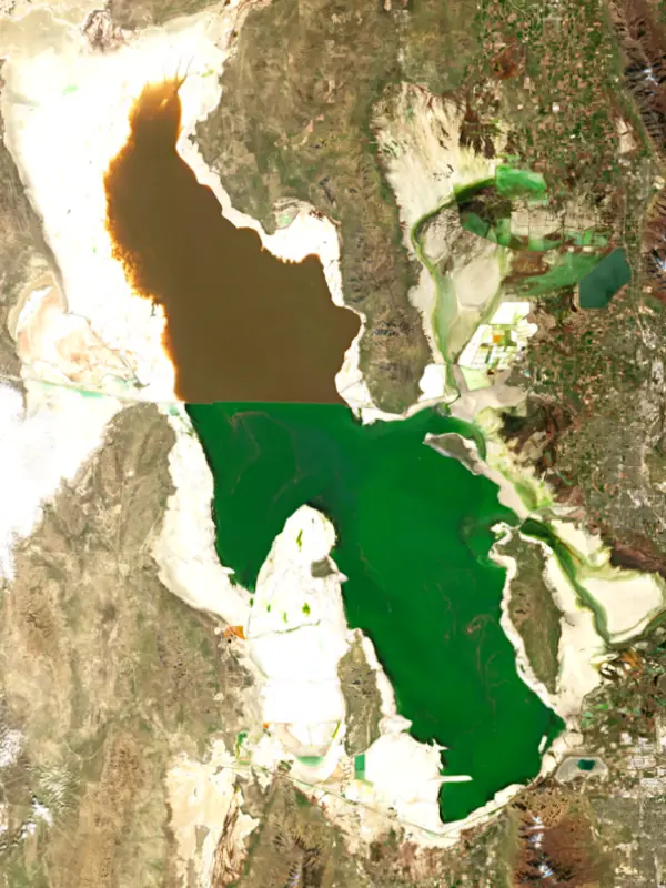
The last 13 satellite passes
83°F · Jul 2352°F · Nov 12
31°F cooler than on Jul 23, 2026.
Estimated from Landsat 8/9 (USGS) passes on clear days: the top layer of the water, a few degrees either way. Coves and the shallows can be warmer.
Great Salt Lake water temperature: trend, swimming and the fish →
On or near the shore of Great Salt Lake: 4 boat ramps, 1 marina, 1 campground, 3 beaches and 1 trail. The lake has about 383 miles of shoreline, counting its islands.
Tap an icon for details; use two fingers (or Ctrl + scroll) to move the map. Tap a dot for details. Map and lake outline © OpenStreetMap contributors. Places from OpenStreetMap, Overture Maps and Recreation.gov. Not for navigation.
No aquatic invasive species are on record for Great Salt Lake in the USGS database. Keep it that way: clean, drain and dry your boat between lakes.
Utah: Every boater, paddlers included, must take the Mussel-Aware Boater course each year, and motorboats need an annual AIS decal; pull drain plugs and sea strainers when leaving any water and while trailering. Boats leaving Lake Powell must be inspected, then professionally decontaminated or dried 7 to 30 days before launching elsewhere. Required: Mussel-Aware Boater course certificate; AIS decal (motorboats) (Course free; AIS decal $20 a year for Utah motorboats, $25 for nonresident motorboats). State rules
Records: USGS Nonindigenous Aquatic Species database. A species not listed may still be present.
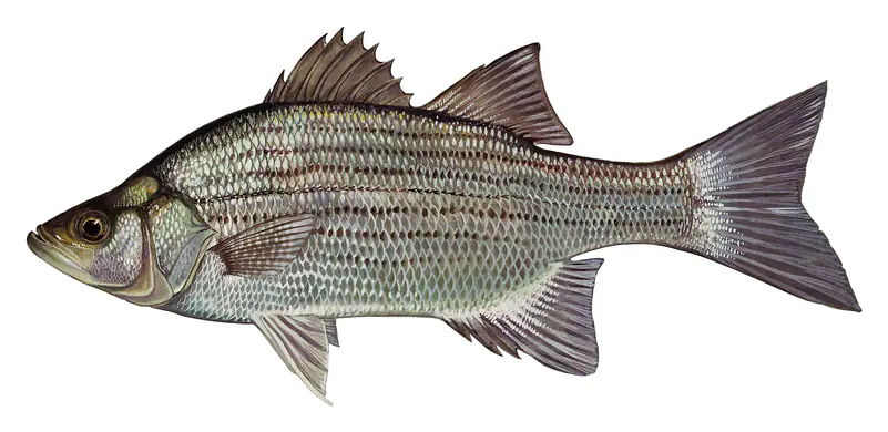
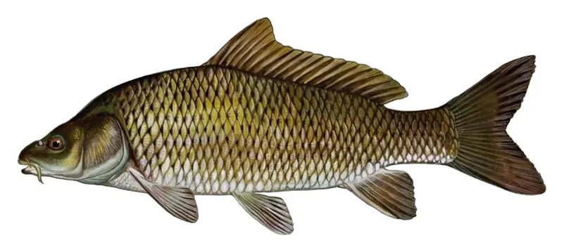
Species with open-licensed records inside Great Salt Lake's outline, from GBIF.org (surveys, museum collections and angler reports). A record shows a fish was found here, not how many there are now.
Spring runs up the tributaries; schools busting shad in late summer.
Shallow, muddy bays and flooded grass in spring; mud flats and inflows in summer.
Water temperature sets off each spawn; the bars show the usual months at this latitude and elevation, and move with a warm or cold spring. The water is about 52°F now.
Great Salt Lake is a shallow, salty lake in northern Utah with no outlet to the sea, the largest saltwater lake in the Western Hemisphere. It is what remains of a far larger Ice Age lake, and it sits beside the cities of the Wasatch Front. Millions of migrating birds, a brine shrimp harvest that supplies fish farms around the world, and the air those cities breathe all depend on how much water reaches it.
The lake is a remnant of Lake Bonneville, which at its largest covered about ten times the area of today's lake before much of it drained north through Red Rock Pass in Idaho. Three rivers feed it now. The Bear, the largest, runs through Idaho before entering the northeast arm, the Weber comes in from the east, and the Jordan carries water from Utah Lake into the southeast corner. Nothing flows out. The lake loses about 2 million acre-feet a year to evaporation, the minerals stay behind, and the water runs roughly 3.5 to 8 times saltier than the ocean. A rock-filled railroad causeway built across the lake in 1959 splits it in two. The north arm gets little river water and is far saltier, while the south arm holds the brine shrimp and brine flies. In December 2016 a 180-foot bridge opened in the causeway to let water move between the arms. Fish are rare in the main lake and turn up mostly in fresher bays near river mouths, such as Bear River Bay and Farmington Bay, during spring runoff.
The Shoshone called the lake Ti'tsa-pa, and in 1776 Timpanogos Utes described it to Silvestre Vélez de Escalante. John C. Frémont led the first scientific expedition to it in 1843. Mormon pioneers reached the Salt Lake Valley in July 1847, Brigham Young went to the lake three days later, and within a month it was supplying the settlers with salt. Saltair has operated on the south shore since 1893. Robert Smithson's earthwork Spiral Jetty, built in 1970 at Rozel Point on the northwest arm, shows only when the water is low.
More than 12 million birds of about 330 species rely on the lake as they migrate between the Arctic and Argentina, and it hosts the largest staging population of Wilson's phalaropes in the world. The Bear River Migratory Bird Refuge, near Brigham City where the Bear meets the lake, has a 12-mile auto tour through marshes where avocets and black-necked stilts nest by the thousands and tundra swans gather in the tens of thousands in spring and fall. Out on the open water, the lake produces an estimated 40 to 45 percent of the world's brine shrimp cysts, the main food for commercial prawn and fish farms. Antelope Island, the largest island, is a state park reached by a 7-mile causeway from Syracuse. Its bison herd grew from 12 animals brought over in 1893 and is rounded up each October. Pronghorn, mule deer and bighorn sheep live there too. The Fielding Garr Ranch house dates from 1848, and the public beaches are on the north end near Bridger Bay.
In a normal year the lake rises 1 to 2 feet with spring runoff and bottoms out in October or November. Record highs in the mid-1980s threatened Interstate 80 and the eastern shore, and in 1987 the state built the West Desert Pumping Project to push water into the desert to the west until it shut down in June 1989. In late 2022 the lake fell to a record low. Exposed lakebed holds naturally occurring and industrial arsenic, lead and mercury that wind can carry toward the cities, and in 2023 the Legislature created the Great Salt Lake Commissioner's Office to lead management of the lake. After two big snow years, the lake rose about 6.5 feet between November 2022 and May 2024.
Written by Lake by Lake from State of Utah, Office of the Great Salt Lake Commissioner (Great Salt Lake, Frequently Asked Questions), U.S. Fish and Wildlife Service and Wikipedia (Great Salt Lake, Antelope Island State Park). Checked November 2026.
Activities: Biking · Boating · Camping · Visitor center · Wildlife viewing · Paddling
Where the level comes from: GREAT SALT LAKE NEAR SALINE, UT (U.S. Geological Survey, used on this page), Great Salt Lake above Great Salt Lake (NOAA National Water Prediction Service) and GREAT SALT LAKE AT SALTAIR BOAT HARBOR, UT (U.S. Geological Survey).
| Lake | Miles | Level (ft) | vs full | 7 days |
|---|---|---|---|---|
| Willard Bay Reservoir Below full | 23 | 4216.84 | −9.16 | +0.26 |
| Pineview Reservoir Well below full | 34 | 4832.90 | −67.10 | — |
| Hyrum Reservoir Well below full | 42 | 4646.92 | −25.08 | +2.14 |
| Causey Reservoir Well below full | 47 | 5665.00 | −27.00 | +2.06 |
| Newton Reservoir Well below full | 52 | 4735.60 | −38.90 | +1.40 |
| East Canyon Reservoir Well below full | 53 | 5664.05 | −40.95 | +0.46 |
Compare Great Salt Lake with Willard Bay Reservoir, Pineview Reservoir, Hyrum Reservoir or Causey Reservoir: size, level, ramps and fish side by side.
Great Salt Lake is about 44 mi from Salt Lake City, UT, 47 mi from West Valley City, UT and 52 mi from West Jordan, UT. See all the lakes near each city.
Great Salt Lake is at 4,189.60 feet above sea level, as of Nov 18, 2026, 11:15 PM MST. It has dropped 0.10 ft in the past 7 days.
Today's level is 5.06 ft below the median for this date (4,194.66 ft), from the gauge’s long-term daily record.
4,188.50 ft, on November 1, 2022, in the U.S. Geological Survey record, which starts in 1966. Today the lake is 1.1 ft above that.
4,211.20 ft, on April 15, 1987, in the U.S. Geological Survey record since 1966.
Great Salt Lake has 4 boat ramps on our map, including Boat ramp at Silver Sands Beach, Great Salt Lake State Marina, Antelope Island State Park, and 1 marina. Low water can close ramps, so check today's level above and the operator before you go.
Yes. There is 1 campground within about a mile of the shore, such as Bridger Bay Campground.
Game fish recorded in Great Salt Lake include white bass, common carp. In all, 6 fish species have open records inside the lake on GBIF.
The water at Great Salt Lake is 52°F, measured 46 min ago by the USGS sensor in the lake. Surface temperature changes through the day and with depth.
Anglers 12 and older need a Utah fishing license, sold online by the Utah Division of Wildlife Resources. Free fishing days: Free Fishing Day, one Saturday in June (2026: June 6). Size and bag limits can be set lake by lake: check the current regulations.
Great Salt Lake is about 35 ft deep at its deepest point. Depth changes with the lake level.
Yes: bathymetric map (south part of the lake) from the U.S. Geological Survey (2005). It is linked in the lake facts on this page. Depths on a map are measured at a reference level: subtract how far the lake is below it today.
Recreation.gov lists biking, boating, camping, visitor center, wildlife viewing and paddling at Great Salt Lake State Park.
EPA's CyAN satellite rated cyanobacteria in Great Salt Lake low on November 9. The satellite sees open water only; blooms can be patchy, so avoid water that looks like spilled paint or pea soup and keep dogs out of scum. Swimming advisories come from Utah health and environment agencies.
Yes. A trail runs along or near the shore, including Lakeside Loop (4.6 mi), according to OpenStreetMap.
From the U.S. Geological Survey (GREAT SALT LAKE NEAR SALINE, UT). Lake by Lake checks it every hour; the agency's own figure is always the reference, and provisional readings can be revised.
Lake levels are refreshed every hour. Texas and California reservoirs report once a day; most USGS and NOAA gauges report every 15 to 60 minutes.
Cookies for analytics With your OK we use Google Analytics and Microsoft Clarity to count visits and see how the site is used, so we can make it better. No advertising cookies. Privacy policy