Sun
- Sunrise
- 7:16 AM
- Sunset
- 5:08 PM
- First light
- 6:46 AM
- Last light
- 5:38 PM
Lake · Utah County, Utah
A lake fed by the Provo River in Utah County, Utah, held back by Utah Lake Outlet Dam since 1988.

Utah Lake is at 4,484.80 feet above sea level — 4.24 ft below legal full level, as of Nov 16, 2026. It has risen 0.19 ft in the past 7 days.
2nd fullest of 24 Utah lakes today against full pool · See the ranking
Record low 4,480.72 ft (2016), record high 4,491.30 ft (2011) · Level history since 2004
A notification from this browser, once, when the level crosses the line (checked every hour). No account and no email. On an iPhone, add Lake by Lake to your home screen first (Share → Add to Home Screen) and open it from there. Or follow the lake in a feed reader: RSS feed.
Utah Lake is up 0.53 ft over the last 30 days, at 4,484.80 ft today.
Daily values from the Bureau of Reclamation (Upper Colorado).
Over the past 12 months, Utah Lake ranged from 4,483.97 ft (Nov 1, 2026) to 4,487.60 ft (Apr 10, 2026), a swing of 3.6 ft. Today's level is in the lower half of that range. It is 1.82 ft lower than on this date last year.
Daily values from the Bureau of Reclamation (Upper Colorado). Why lake levels rise and fall
In the Bureau of Reclamation (Upper Colorado) record, which starts in 2004, the lowest level was 4,480.72 ft on November 16, 2016 and the highest 4,491.30 ft on July 11, 2011. Today’s 4,484.80 ft is 4.1 ft above the record low and 6.5 ft below the record high.
Utah Lake level history: every year since 2004, the lowest and highest years →
Solunar periods for Utah Lake, local time. How they work
A bloom may be developing: look at the water before you go in and keep dogs away from scum.
From the Utah Department of Environmental Quality, checked Nov 16. Advisories change with the weather: check the agency's page and the signs at the water before you go.
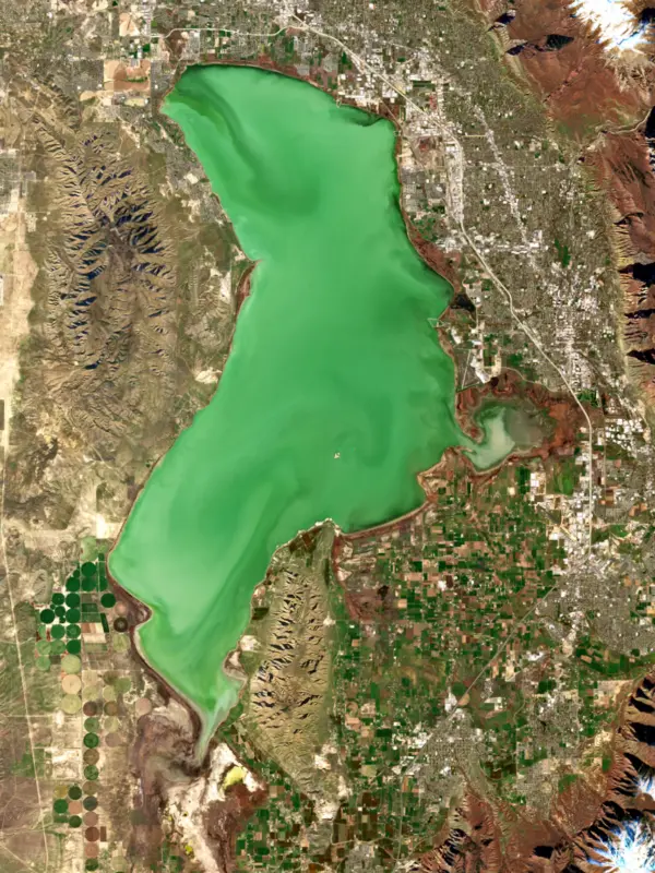
Very high · as of Nov 9, 2026
The satellite sees a strong bloom on part of the lake. Stay out of discolored water, keep pets away and check for state advisories. About 2,470,000 cells/mL at the worst spot, covering 81% of the lake.
Week of Aug 16Week of Nov 1
Each bar is one week, colored by the worst reading of that week.
From the U.S. EPA's Cyanobacteria Assessment Network (CyAN), which reads the color of lakes from the Sentinel-3 satellites; it sees open water only, not coves or the shoreline. Blooms can be patchy: what you see on the water matters more. Swimming closures and health advisories come from Utah health and environment agencies. How to read it
Surface water temperature
50°F on Nov 12, 2026
82°F · Jul 2350°F · Nov 12
33°F cooler than on Jul 23, 2026.
Estimated from Landsat 8/9 (USGS) passes on clear days: the top layer of the water, a few degrees either way. Coves and the shallows can be warmer.
On or near the shore of Utah Lake: 14 boat ramps, 7 marinas, 3 rental outfits, 2 campgrounds, 3 beaches, 7 trails and 1 fishing guide. The lake has about 95 miles of shoreline, counting its islands.
Tap an icon for details; use two fingers (or Ctrl + scroll) to move the map. Tap a dot for details. Map and lake outline © OpenStreetMap contributors. Places from OpenStreetMap, Overture Maps and Recreation.gov. Not for navigation.
What you’ll find on the shore
← AllBoating 21
← AllRentals & tours 3
← AllFishing spots 4
← AllBeaches 3
← AllCamping 2
← AllLodging 1
← AllTrails 7
← AllParks 5
No aquatic invasive species are on record for Utah Lake in the USGS database. Keep it that way: clean, drain and dry your boat between lakes.
Utah: Every boater, paddlers included, must take the Mussel-Aware Boater course each year, and motorboats need an annual AIS decal; pull drain plugs and sea strainers when leaving any water and while trailering. Boats leaving Lake Powell must be inspected, then professionally decontaminated or dried 7 to 30 days before launching elsewhere. Required: Mussel-Aware Boater course certificate; AIS decal (motorboats) (Course free; AIS decal $20 a year for Utah motorboats, $25 for nonresident motorboats). State rules
Records: USGS Nonindigenous Aquatic Species database. A species not listed may still be present.
Species with open-licensed records inside Utah Lake's outline, from GBIF.org (surveys, museum collections and angler reports). A record shows a fish was found here, not how many there are now.
Shallow, protected flats in spring; docks, grass and deep edges in summer heat.
Brush piles, docks and bridge pilings; shallow for a few weeks in spring.
Channel edges and river arms; best after dark in summer, and after a rain.
Rocky shorelines at night after ice-out; deep weed edges and humps in summer.
Cool water: near the surface in spring and fall, deep in summer.
Water temperature sets off each spawn; the bars show the usual months at this latitude and elevation, and move with a warm or cold spring. The water is about 50°F now.
Utah Lake covers the floor of Utah Valley in Utah County, the largest freshwater lake in the state and a shallow remnant of ancient Lake Bonneville. Snowmelt from the mountains to the east feeds it, and the Jordan River carries its outflow north to the Great Salt Lake. It sits in the middle of the valley, within easy reach of most people who live there.
About 20,000 years ago Lake Bonneville covered much of Utah, and the ground under today's lake lay roughly 500 feet below its surface. Around 15,000 years ago Bonneville spilled into Idaho's Snake River valley in the Bonneville Flood and began to shrink, and Utah Lake is one of the pieces it left.
The Provo River, Spanish Fork, American Fork, Hobble Creek, Benjamin Slough and Currant Creek all reach it, but springs and groundwater supply a large share of its water too. The Jordan River is the only surface outlet, and water users run a dam and pumping station there, setting the release by demand. The lake's milky look comes mainly from calcium carbonate washed down from limestone mountains on the east side, kept in suspension by wind and by carp rooting in the soft bottom.
The Timpanogos people lived beside the lake and fished it long before Father Silvestre Velez de Escalante recorded it in 1776. Latter-day Saints settled the valley in 1849 and built Fort Utah. When crops failed in 1855 and 1856, June sucker from the lake kept many settlers from starving. Overfishing and water diversions then cut the native fish down, and new species were stocked in their place, including black bullhead in 1872, common carp in 1883, largemouth bass in 1890 and white bass in 1956.
Carp did the most damage. They uprooted the pondweed and other plants that sheltered small native fish, and by the early 2000s they made up more than 90 percent of the fish by weight. A removal program that began in 2009 has taken out about 35 million pounds. The June sucker, found nowhere else in the world, was listed as endangered in 1986 and fell to a few hundred spawning fish. It was moved to threatened in 2021. The newest piece of its recovery is the Provo River Delta, nearly 260 acres of rebuilt wetland half a mile north of Utah Lake State Park, opened in October 2024 with trails, fishing platforms, launches for boats without motors, and an observation tower. In 2024 alone, 3,785 tagged June suckers were detected spawning there.
More than 25 non-native species now live in the lake. Anglers come mostly for channel catfish, white bass, walleye, bluegill and crappie, and the white bass spawning run can produce a fish on nearly every cast. The lake is shallow and mostly wadeable, so a boat is optional. Utah Lake State Park near the mouth of the Provo River, Lindon Marina, Saratoga Springs City Marina and Lincoln Beach at the south end are the main public access points. Boaters must do a self-inspection for invasive mussels before launching and complete the state's mussel-aware course.
Raw sewage went into the lake until treatment plants were built in the middle of the 20th century, and the water is still very rich in nutrients. A state study traced about 77 percent of its phosphorus to wastewater plants. Algal blooms come mostly in summer and early fall, and Provo Bay and the east shore are the usual hot spots. During a bloom, stay out of water with visible scum, keep pets out, and check the state's bloom warnings before a trip.
In October 2022 the Utah Division of Forestry, Fire and State Lands rejected a private plan to dredge the lake and build 34 artificial islands on it. The state said the project would block navigation and hand public lakebed to private owners. The company behind it dissolved in 2023.
Written by Lake by Lake from Brigham Young University, Department of Plant and Wildlife Sciences, Utah Lake Authority (Frequently Asked Questions, Utah Lake is a good place to fish), U.S. Department of the Interior, Deseret News and KSL. Checked November 2026.
Activities: Boating · Camping · Fishing · Picnicking · Winter sports · Water sports · Photography · Paddling
Utah Lake Outlet Dam is an earthfill dam 9 feet high and 1,100 feet long, completed in 1988. It belongs to Utah Lake Water Association, INC. and is run for water supply. At its normal level the lake holds 1.37 million acre-ft, drained from 3,010 square miles of land.
From the National Inventory of Dams (U.S. Army Corps of Engineers), NID ID UT00673. Lake or reservoir: what’s the difference?
Where the level comes from: Utah Lake (Bureau of Reclamation (Upper Colorado)).
| Lake | Miles | Level (ft) | vs full | 7 days |
|---|---|---|---|---|
| Deer Creek Reservoir Live reading | 19 | 5383.27 | — | — |
| Jordanelle Reservoir Well below full | 30 | 6116.83 | −52.17 | +0.39 |
| Rockport Reservoir Well below full | 39 | 5996.54 | −40.46 | +0.51 |
| East Canyon Reservoir Well below full | 41 | 5664.05 | −40.95 | +0.46 |
| Currant Creek Reservoir At or near full pool | 44 | 7676.70 | −1.30 | −0.21 |
| Strawberry Reservoir Well below full | 48 | 7585.72 | −16.68 | −0.06 |
Compare Utah Lake with Deer Creek Reservoir, Jordanelle Reservoir, Rockport Reservoir or East Canyon Reservoir: size, level, ramps and fish side by side.
Utah Lake is about 15 mi from Provo, UT, 18 mi from West Jordan, UT and 24 mi from West Valley City, UT. See all the lakes near each city.
Utah Lake is at 4,484.80 feet above sea level — 4.24 ft below legal full level, as of Nov 16, 2026. It has risen 0.19 ft in the past 7 days.
Utah Lake's legal full level is 4,489.05 ft, according to the 1885 Utah Lake compromise (Bureau of Reclamation). Today the lake is 4.24 ft below that mark.
Today's level is 1.61 ft below the median for this date (4,486.41 ft), from the gauge’s long-term daily record.
4,480.72 ft, on November 16, 2016, in the Bureau of Reclamation (Upper Colorado) record, which starts in 2004. Today the lake is 4.1 ft above that.
4,491.30 ft, on July 11, 2011, in the Bureau of Reclamation (Upper Colorado) record since 2004. That is 2.3 ft above legal full level.
Utah Lake has 14 boat ramps on our map, including American Fork Boat Harbor, Lincoln Point, Lindon Boat Harbor, and 7 marinas. Low water can close ramps, so check today's level above and the operator before you go.
Yes. There are 2 campgrounds and RV parks within about a mile of the shore, such as Sandy Beach, Lakeside RV Campground.
Game fish recorded in Utah Lake include channel catfish, white bass, walleye, yellow perch, largemouth bass, bluegill. In all, 25 fish species have open records inside the lake on GBIF.
The surface of Utah Lake was about 50°F on November 12, estimated from a satellite pass on a clear day. It is the top layer of the water, a few degrees either way; coves and shallows run warmer in the sun.
Anglers 12 and older need a Utah fishing license, sold online by the Utah Division of Wildlife Resources. Free fishing days: Free Fishing Day, one Saturday in June (2026: June 6). Size and bag limits can be set lake by lake: check the current regulations.
Utah Lake is about 14 ft deep at its deepest point. Depth changes with the lake level.
In summer a white Secchi disk lowered into Utah Lake stays visible to about 0.8 ft (the median of 407 readings, 2016–2025, by Utah Department Of Environmental Quality): murky water. With the algae measured too (chlorophyll about 28 µg/L), that makes it hypereutrophic: very rich in nutrients, prone to algae. Clarity drops after storms and during algae blooms.
Recreation.gov lists boating, camping, fishing, picnicking, winter sports, water sports, photography and paddling at Utah Lake State Park.
EPA's CyAN satellite rated cyanobacteria in Utah Lake very high on November 9. The satellite sees open water only; blooms can be patchy, so avoid water that looks like spilled paint or pea soup and keep dogs out of scum. Swimming advisories come from Utah health and environment agencies.
Yes. 7 trails run along or near the shore, including Utah Lake Shoreline Trail (6.8 mi), Walking Path (2.2 mi) and Lakefront Trail (0.5 mi), according to OpenStreetMap.
Utah Lake is held back by Utah Lake Outlet, completed in 1988 and 9 ft high, according to the National Inventory of Dams.
From the Bureau of Reclamation (Upper Colorado) (Utah Lake). Lake by Lake checks it every hour; the agency's own figure is always the reference, and provisional readings can be revised.
Lake levels are refreshed every hour. Texas and California reservoirs report once a day; most USGS and NOAA gauges report every 15 to 60 minutes.




