Sun
- Sunrise
- 6:51 AM
- Sunset
- 4:16 PM
- First light
- 6:19 AM
- Last light
- 4:48 PM
Lake · Orleans County, Vermont
A lake fed by the Rivière aux Cerises in Orleans County, Vermont.

Lake Memphremagog is at 679.53 feet above sea level, as of Nov 19, 2026, 2:00 AM EST. It has dropped 0.12 ft in the past 7 days. That is the lowest level since 2014.
Lowest of 3 Vermont lakes today against normal for the date · See the ranking
Record low 679.52 ft (1968), record high 685.92 ft (1933) · Level history since 1931
A notification from this browser, once, when the level crosses the line (checked every hour). No account and no email. On an iPhone, add Lake by Lake to your home screen first (Share → Add to Home Screen) and open it from there. Or follow the lake in a feed reader: RSS feed.
Lake Memphremagog is down 0.12 ft over the last 7 days, at 679.53 ft today.
Daily values from the U.S. Geological Survey.
Lake Memphremagog is down 0.49 ft over the last 30 days, at 679.53 ft today.
Daily values from the U.S. Geological Survey.
Over the past 12 months, Lake Memphremagog ranged from 679.54 ft (Nov 18, 2026) to 683.27 ft (Jun 21, 2026), a swing of 3.7 ft. Today's level is the lowest of the past 12 months. It is 1.06 ft lower than on this date last year.
Daily values from the U.S. Geological Survey. Why lake levels rise and fall
In the U.S. Geological Survey record, which starts in 1931, the lowest level was 679.52 ft on November 7, 1968 and the highest 685.92 ft on April 20, 1933. Today’s 679.53 ft is 0.0 ft above the record low and 6.4 ft below the record high. That is the lowest level since 2014.
Lake Memphremagog level history: every year since 1931, the lowest and highest years →
Solunar periods for Lake Memphremagog, local time. How they work
Not detected · as of Nov 9, 2026
The satellite found no cyanobacteria at the surface.
Week of Aug 16Week of Nov 1
Each bar is one week, colored by the worst reading of that week.
From the U.S. EPA's Cyanobacteria Assessment Network (CyAN), which reads the color of lakes from the Sentinel-3 satellites; it sees open water only, not coves or the shoreline. Blooms can be patchy: what you see on the water matters more. Swimming closures and health advisories come from Vermont health and environment agencies. How to read it
Surface water temperature
51°F on Nov 5, 2026
70°F · Jul 2451°F · Nov 5
19°F cooler than on Jul 24, 2026.
Estimated from MODIS Aqua (NASA) passes on clear days: the top layer of the water, a few degrees either way. Coves and the shallows can be warmer.
Lake Memphremagog water temperature: trend, swimming and the fish →
On or near the shore of Lake Memphremagog: 18 boat ramps, 16 marinas, 4 rental outfits, 6 campgrounds, 15 beaches and 4 trails. The lake has about 112 miles of shoreline, counting its islands.
Tap an icon for details; use two fingers (or Ctrl + scroll) to move the map. Tap a dot for details. Map and lake outline © OpenStreetMap contributors. Places from OpenStreetMap, Overture Maps and Recreation.gov. Not for navigation.
What you’ll find on the shore
← AllBoating 34
← AllRentals & tours 6
← AllFishing spots 2
← AllBeaches 15
← AllCamping 6
← AllLodging 24+
← AllTrails 4
← AllParks 7
← AllDining 24+
Zebra mussels have been found in Lake Memphremagog. They clog intakes and engines and spread on boats and trailers: clean, drain and dry everything before you go to another lake.
Vermont: Inspect your boat, trailer and vehicle and remove all plants and animals before launching and when leaving; drain bilges, livewells and ballast before leaving the access and keep drain plugs out while trailering. Inspection and decontamination are mandatory at staffed state stations when you are directed to one. State rules
Records: USGS Nonindigenous Aquatic Species database. A species not listed may still be present.
Species with open-licensed records inside Lake Memphremagog's outline, from GBIF.org (surveys, museum collections and angler reports). A record shows a fish was found here, not how many there are now.
Shallow, protected flats in spring; docks, grass and deep edges in summer heat.
Rocky points, gravel and current breaks; deeper rock piles in summer.
Rocky shorelines at night after ice-out; deep weed edges and humps in summer.
Cool water: near the surface in spring and fall, deep in summer.
Low light and cold water; the inflows in fall.
Water temperature sets off each spawn; the bars show the usual months at this latitude and elevation, and move with a warm or cold spring. The water is about 51°F now.
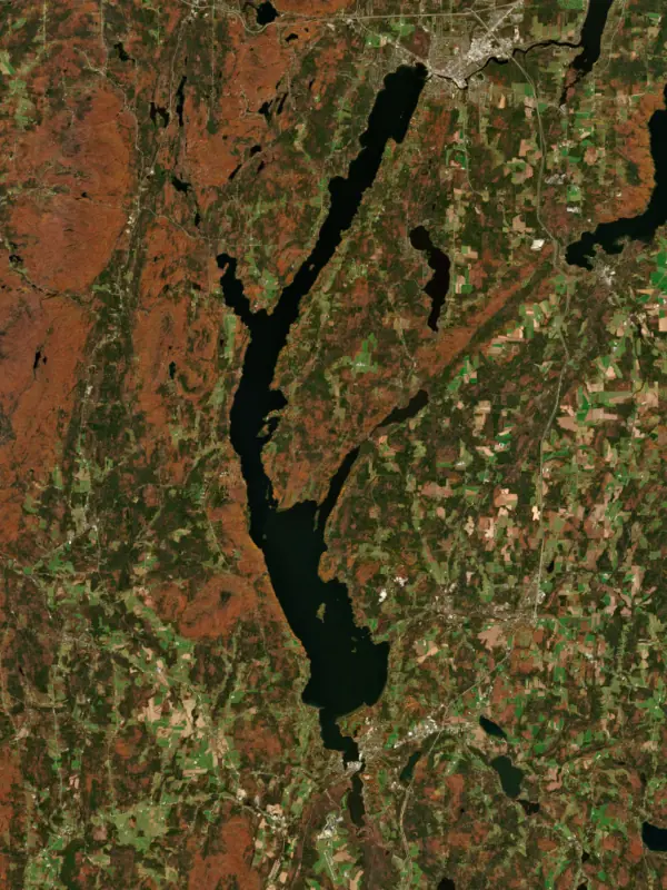
Lake Memphremagog is a long, deep glacial lake that runs about 31 miles from Newport, Vermont, north across the Canadian border to Magog, Quebec. About three-quarters of its surface is in Quebec, but most of the land that drains into it is in Vermont, where it is the second largest body of water in the state. On both sides of the border it is known for lake trout, landlocked salmon and perch, and it supplies drinking water to about 200,000 people.
The name comes from Abenaki words usually translated as where there is a big expanse of water. In 1753 a party of Abenaki brought their prisoner John Stark down the lake to the Newport area, and in 1759 Rogers' Rangers broke into small parties on its east shore as they retreated from their raid on Saint-Francis. Steamboats later ran the length of the lake. The Lady of the Lake, launched in 1867, made the trip from Newport to Magog in about three hours.
The lake holds 21 islands. The largest, Province Island, is cut by the international boundary, with roughly a tenth of it in the United States. The abbey of Saint-Benoît-du-Lac and the mountain of Owl's Head stand along the western shore. Stories of a lake creature called Memphre go back to the 18th century.
The lake drains through the Magog River at its northern end. In 1920 residents of Newport and nearby towns petitioned Washington, saying a Dominion Textile Company power dam at the outlet in Quebec had raised the lake several feet above normal and damaged property along the shore and up the Clyde, Barton and Black rivers. Each government named an engineer to an International Lake Memphremagog Board, which reported in 1934. In 1935 the two countries accepted its rules by an exchange of notes. The lake would be held within a set range in normal years, and in floods the sluiceways at the dam would be opened so water could leave freely. Future complaints were to go to the International Joint Commission.
The Clyde, Barton, Black and Johns rivers all flow in from Vermont, and the farms, roads and towns along them send phosphorus into the lake. The deeper Quebec end has less phosphorus and meets its local guidelines, while the Vermont portion still falls short of its water quality standards. In 2017 the U.S. Environmental Protection Agency approved a Vermont plan to cut the phosphorus flowing into the lake by 29 percent. Farms supply about 46 percent of that load, and developed land and eroding stream banks most of the rest.
The Clyde River once had runs of landlocked salmon weighing 10 to 20 pounds. Habitat loss, overfishing and a string of small dams wore the run down, and the Newport No. 11 diversion dam, built in 1957, nearly finished it. After spring floods damaged that dam in 1994, federal regulators ordered it removed in 1996, the first time they had ordered a dam taken out to restore a river. Salmon running up from the lake climb fish ladders at the remaining dams, wait a few days in a holding tank and are released upstream. The state stocks young salmon that grow in the lake and come back to spawn about a year and a half later, and some fish now reproduce in the lower river.
A Vermont Fish and Wildlife survey on both sides of the border from 2018 to 2020 found anglers keeping large numbers of lake trout, landlocked salmon, rainbow trout, yellow perch and white perch. Vermont anglers favored trout and salmon through the ice and bass in open water, while Quebec anglers leaned toward salmon and trout in summer and perch in winter.
Written by Lake by Lake from U.S. Department of State, Office of the Historian, Vermont Fish and Wildlife Department, Vermont Public, Vermont River Conservancy, WCAX and Wikipedia. Checked November 2026.
Where the level comes from: LAKE MEMPHREMAGOG AT NEWPORT, VT (U.S. Geological Survey, used on this page) and Lake Memphremagog at Newport (NOAA National Water Prediction Service).
| Lake | Miles | Level (ft) | vs full | 7 days |
|---|---|---|---|---|
| Lake Francis Live reading | 41 | 1372.44 | — | +0.26 |
| Waterbury Reservoir Live reading | 47 | 589.73 | — | +0.03 |
| Lake Champlain Live reading | 59 | 93.74 | — | −0.10 |
| Rangeley Lake Live reading | 75 | 1516.06 | — | −0.14 |
| Squam Lake Live reading | 89 | 560.56 | — | −0.16 |
| Mascoma Lake Live reading | 89 | 748.05 | — | −0.12 |
Compare Lake Memphremagog with Lake Francis, Waterbury Reservoir, Lake Champlain or Rangeley Lake: size, level, ramps and fish side by side.
Lake Memphremagog is at 679.53 feet above sea level, as of Nov 19, 2026, 2:00 AM EST. It has dropped 0.12 ft in the past 7 days. That is the lowest level since 2014.
Today's level is 2.59 ft below the median for this date (682.12 ft), from the gauge’s long-term daily record.
679.52 ft, on November 7, 1968, in the U.S. Geological Survey record, which starts in 1931. Today the lake is 0.0 ft above that.
685.92 ft, on April 20, 1933, in the U.S. Geological Survey record since 1931.
Lake Memphremagog has 18 boat ramps on our map, including Boat ramp at Capitainerie de l'Émeraude, Boat ramp at Marina Audet, Boat ramp at Marina Fitch Bay, and 16 marinas. Low water can close ramps, so check today's level above and the operator before you go.
Yes. There are 6 campgrounds and RV parks within about a mile of the shore, such as Domaine Ruisseau Château, Camping Weir, Cedar Lodge Camp.
Game fish recorded in Lake Memphremagog include largemouth bass, smallmouth bass, walleye, rainbow trout, brown trout, lake trout. In all, 13 fish species have open records inside the lake on GBIF.
The surface of Lake Memphremagog was about 51°F on November 5, estimated from a satellite pass on a clear day. It is the top layer of the water, a few degrees either way; coves and shallows run warmer in the sun.
Anglers 15 and older need a Vermont fishing license, sold online by the Vermont Fish and Wildlife Department. Free fishing days: Second Saturday in June and last Saturday in January. Size and bag limits can be set lake by lake: check the current regulations.
Lake Memphremagog is about 351 ft deep at its deepest point, and about 121 ft deep on average. Depth changes with the lake level.
In summer a white Secchi disk lowered into Lake Memphremagog stays visible to about 9.8 ft (the median of 170 readings, 2016–2025, by Vermont Dept of Environmental Conservation and North American Lake Management Society): clear water. With the algae measured too (chlorophyll about 6 µg/L), that makes it mesotrophic: moderately rich in nutrients. Clarity drops after storms and during algae blooms.
Yes: bathymetric map (Vermont portion) from the Vermont Department of Environmental Conservation (2016). It is linked in the lake facts on this page. Depths on a map are measured at a reference level: subtract how far the lake is below it today.
boating (18 boat ramps and 16 marinas), kayaks, boats & jet skis (4 rental outfits on or near the water), boat tours (2 boat tours and charters), fishing (9 game fish), swimming (15 beaches and swimming areas) and hiking & walking (4 trails along the shore, the longest Newport Bike Path and Beebe Spur Rail Trail (6.1 mi)), according to our map of the shore.
EPA's CyAN satellite rated cyanobacteria in Lake Memphremagog not detected on November 9. The satellite sees open water only; blooms can be patchy, so avoid water that looks like spilled paint or pea soup and keep dogs out of scum. Swimming advisories come from Vermont health and environment agencies.
Yes. 4 trails run along or near the shore, including Newport Bike Path and Beebe Spur Rail Trail (6.1 mi), Scott's Cove Trail (0.3 mi) and Larry's Loop (0.4 mi), according to OpenStreetMap.
From the U.S. Geological Survey (LAKE MEMPHREMAGOG AT NEWPORT, VT). Lake by Lake checks it every hour; the agency's own figure is always the reference, and provisional readings can be revised.
Lake levels are refreshed every hour. Texas and California reservoirs report once a day; most USGS and NOAA gauges report every 15 to 60 minutes.
Cookies for analytics With your OK we use Google Analytics and Microsoft Clarity to count visits and see how the site is used, so we can make it better. No advertising cookies. Privacy policy




