Lake Champlain water level today

Source: U.S. Geological Survey

Lake Champlain is at 93.74 feet above sea level, as of Nov 17, 2026, 9:00 PM EST. It has dropped 0.08 ft in the past 7 days.

Live reading Reading 2 hr ago

vs normal for the date
−1.20 ft
Last 24 hours
—
Last 7 days
−0.08 ft
Last 30 days
−0.32 ft
vs a year ago
−1.20 ft

2nd highest of 3 Vermont lakes today against normal for the date · See the ranking

Record low 92.61 ft (1908), record high 103.19 ft (2011) · Level history since 1907

Get an alert when Lake Champlain changes

    A notification from this browser, once, when the level crosses the line (checked every hour). No account and no email. Or follow the lake in a feed reader: RSS feed.

    Over the past 12 months, Lake Champlain ranged from 93.68 ft (Oct 11, 2026) to 98.62 ft (Apr 20, 2026), a swing of 4.9 ft. Today's level is near the bottom of that range. It is 1.20 ft lower than on this date last year.

    94 96 98 100 DecFebAprJunAugOct
    Daily level (ft) A year earlier (2024–25) Normal for the date Normal range (middle half of past years) Now

    Daily values from the U.S. Geological Survey. Why lake levels rise and fall

    Put the Lake Champlain level on your website

    Free for marinas, fishing clubs, lake associations and anyone with a website. The card updates on its own and links here for the full chart.

    Cards for other lakes →

    Lake Champlain weather & fishing times

    Forecast

    Loading the forecast for Lake Champlain…

    Hourly wind, sunrise and sunset and the weather by month →

    Sun, moon & fishing times

    Sun

    Sunrise
    6:51 AM
    Sunset
    4:23 PM
    First light
    6:20 AM
    Last light
    4:55 PM

    Moon

    First Quarter
    52% lit
    Moonrise
    12:54 PM
    Moonset
    11:47 PM

    Fishing times

    Fair day

    • Major 4:54 AM – 6:54 AM
    • Minor 12:24 PM – 1:24 PM
    • Major 5:16 PM – 7:16 PM
    • Minor 11:17 PM – 12:17 AM

    Solunar periods for Lake Champlain, local time. How they work

    The water

    State algae advisories

    • High Alert At 184 Converse Bay since Nov 11
    • Low Alert At Pt. Au Roche State Park- Deep Bay since Nov 12

    Avoid scum and discolored water, and keep dogs out of it.

    From the Vermont Department of Health, checked Nov 16. Advisories change with the weather: check the agency's page and the signs at the water before you go.

    Algae from space

    High · as of Nov 6, 2026

    The satellite sees a likely bloom on part of the lake. Avoid discolored water and scum, and keep dogs out of it. About 377,000 cells/mL at the worst spot, covering 6% of the lake.

    Week of Aug 16Week of Nov 1

    Each bar is one week, colored by the worst reading of that week.

    From the U.S. EPA's Cyanobacteria Assessment Network (CyAN), which reads the color of lakes from the Sentinel-3 satellites; it sees open water only, not coves or the shoreline. Blooms can be patchy: what you see on the water matters more. Swimming closures and health advisories come from Vermont health and environment agencies. How to read it
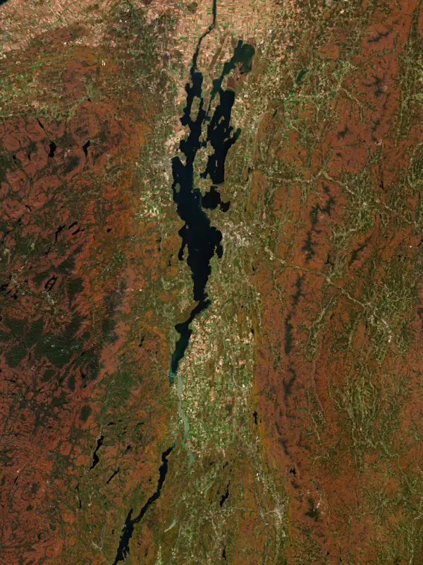
    From space

    Lake Champlain seen from the Sentinel-2 satellite on Oct 23, 2026
    Satellite view, Oct 23, 2026. Contains modified Copernicus Sentinel data 2026.

    The last 12 satellite passes

    71°F · Jul 2552°F · Nov 8

    19°F cooler than on Jul 25, 2026.

    Estimated from MODIS Aqua (NASA) passes on clear days: the top layer of the water, a few degrees either way. Coves and the shallows can be warmer.

    Lake Champlain water temperature: trend, swimming and the fish →

    On or near the shore of Lake Champlain: 66 boat ramps, 63 marinas, 8 rental outfits, 56 campgrounds, 54 beaches, 3 fishing piers, 20 trails and 1 fishing guide. The lake has about 613 miles of shoreline, counting its islands.

    Appletree Bay · Beach Barcomb's Marina · Marina Bay Harbor Marina · Marina Beach House VT · Restaurant Bird House Heaven · Park Black Sand Beach · Beach Blodgett Beach · Beach Bridge Road Marina · Marina Bridgeview Harbour Marina Mooring Field · Marina Burlington Fishing Pier · Fishing pier Burlington Harbor Marina · Marina Camp Everest, Everest Beach · Beach Champlain Bridge Marina · Marina Chipman Point Marina · Marina Community Boathouse Marina · Marina Ferry Dock Marina · Marina Gaines Marina · Marina Ladds Landing Marina · Marina Lake Champlain · Park Lake Champlain Pier · Marina Lakeside Beach Access · Beach Latitude 45 · Restaurant Let's Go Sailing · Boat tour North Beach · Beach North Beach, Burlington, Vt. · Beach North Country National Scenic Trail (NY) · Trail North Country National Scenic Trail (VT) · Trail North Perimeter Trail · Trail Old Dock House and Marina · Restaurant Original Tiki Tours, Burlington · Boat tour Perkins Pier · Marina Plage Philipsburg · Beach Plage Saint-Pierre · Beach Plattsburgh Boat Basin · Marina Point Bay Marina · Marina Port Henry Marina · Marina Royal Savage Trail · Trail South Perimeter Trail · Trail Splash At the Boathouse · Restaurant Texaco Beach · Beach Thayer Beach · Beach The Alburgh Dunes · Beach The Moorings · Marina Willow · Lodging Willsboro Bay · Park Willsboro Bay Marina · Marina Shelburne Beach · Beach Burlington Greenway · Trail Mary Crest Beach · Beach Alburg Dunes · Beach Blanchard Beach · Beach Leddy Park Beach · Beach Whitehall Marina · Marina Champlain Valley Trail (Ticonderoga to Westport) · Trail Port Henry Village Beach · Beach Rosetti Beach Colchester · Beach Bridgeview Harbour Marina · Marina Causeway Park and Rec Path · Park Champlain Valley Trail (Plattsburgh to Canada Border) · Trail Northshore Beach · Beach Bulwagga Bay Beach · Beach Buoy 39 Marina Inc · Marina Ausable Point · Campground Champlain Valley Trail (Westport to Keeseville) · Trail Dana's Cafe Mooney Bay · Restaurant Keeler Bay Marina · Marina Monty's Bay Marina · Marina Plage Miller · Beach Rouses Point Yacht Club · Marina Camp Prescott · Lodging Champlain Valley Trail (Keeseville to Plattsburgh) · Trail Oakledge Cove · Beach Plattsburgh City Beach · Beach La Tropézienne · Restaurant Marina At Lighthouse Point · Marina North Hero State Park · Park Plage Missisquoi · Beach Plage Venise · Beach Port Henry Beach · Beach Spot on the Dock · Restaurant The Mariner Bar And Gr · Restaurant Apple Island Marina · Marina Lake Champlain Community Sailing Center · Marina Le Bistro Dulac · Restaurant Le Quai 260 - resto - bar - terrasse - · Restaurant Le Sandbar · Restaurant Peru Dock Boat Launch · Marina Carry Bay Getaway · Lodging Dana's Rusty Anchor · Restaurant Sand Bar Causeway · Restaurant Sand Bar National Waterfowl Management Area · Park Westport Beach · Beach Champlain Classic Charters · Rental Charlotte Sailing Center · Marina International Sailing School · Marina Le Shack de la Marina · Restaurant Safe Harbor Shelburne Shipyard · Marina Champlain Valley Trail (Whitehall to Ticonderoga) · Trail Essex Shipyard Marina · Marina Portside Restaurant · Restaurant Camping Les Acres Verts · Campground Holiday Harbor Motel · Lodging Rockledge - Long Point · Lodging Westport Marina · Marina Westport Yacht Club · Restaurant Bayside Beach · Beach Champlain Marina · Marina Lady on the Lake · Lodging Sunnywood · Lodging Tex Mex Taco · Restaurant Farmers and Foragers Dockside · Restaurant Shelburne Town Beach · Beach Begg's Park · Park Cliff Haven Private Beach · Beach Essex Marina · Marina Hog Island Bait · Bait & tackle Little Cove Marina · Marina Burlington Surf Club · Beach Noblewood Park · Park Bum Beach South · Beach Lake View Lodge · Lodging Lamplighter Summer Cottage · Lodging Niquette's Bay Camps · Park The New Tavern at Lock 12 · Restaurant Ausable Marsh State Game Management Area · Park Cozy Cottages · Lodging King's Bay Campground · Campground Plage Kirkland · Beach PaddleSurf Champlain · Rental Sunset View on Mallett's Bay · Beach Lakeshore Stays · Lodging Moorings Marina · Marina Sportsman Campground and Cottages · Campground Bravo Zulu Lakeside Bar · Restaurant Camp Everest, Milton Vermont · Lodging Nauti Paddle · Boat tour Sand Bar Inn · Lodging White's Beach · Beach Ferrisburg Town Beach · Beach Ruthcliffe Lodge · Lodging Naked Turtle · Restaurant Normandie Beach Resort · Lodging Plage Kirkland · Campground Port Henry Boat Launch · Marina Port Kent Public Beach Park · Beach Watch Point Inn & Cottages · Lodging Charlotte Town Beach · Beach New England Powerboat · Marina Parc Jameson · Park Brailer Beach · Beach Brown Ledge Camp · Campground Galley Restaurant and Bar · Restaurant Champlain Adult Campground · Campground Papa Petes Snack bar · Restaurant Sailing Sea To See · Boat tour Susan Bachner Memorial Trail · Trail Aventures Lac Champlain · Boat tour Jameson Park · Beach Port Douglass Boat Launch · Marina Roundhouse Park · Park Safe Harbor Gaines · Marina Taste of Champlain · Lodging The Red Cottage-Willsboro Bay Rental, Lake Champlain · Lodging McCuen Slang Access Area · Fishing pier Pink Pig Cafe · Restaurant Campbell's Bay Campground · Campground Georgia Municipal Recreation Area · Park Isle View Cottages on Lake Champlain · Lodging Carry Bay Campground · Campground Mayes Landing · Park Yandow Cottages · Campground Coates Island Marina · Marina St Albans Bay Marina LLC · Marina Burlington Surf Club · Rental Camp Edgewater Beach · Beach Vt State Parks - Sandb · Park Marina At Marble Island · Marina Camping Plage Venise · Campground Georgia Shore-Lake Champlain · Beach Terry Gordon Bike Path · Trail Champ RV Park · Park Henry's Sportsman's Cottages · Campground Sail Wild Air · Rental Lakewood Estates Beach Club · Park Waterfront Park · Park Indian Bay Marina and Restaurant · Marina Port Henry Beach and Campground · Campground Westport Boat Launch · Marina Cumberland Beach Plattsburg · Park Crescent Beach · Beach Grand Isle State Park · Campground Georgia Shore Beach Park · Park Willsboro Bay Boat Launch · Marina Camping MILLER · Campground Valcour Island Marina · Marina Appletree Point Beach · Beach Lake Champlain Community Sailing Center · Rental Valcour Boat Rentals · Rental Camping du Lac · Campground Safe Harbor Willsboro Bay · Marina Ladd's Landing Marina · Marina Hôtel du Lac Champlain, an Ascend Collection Hotel · Lodging Sticks Beach · Beach Eastern Industries · Campground La Cache du Lac Champlain · Lodging Camping Domaine du Lac · Campground Camping Philipsburg · Campground Champs RV Resort · Campground North Hero Marina · Marina East Trail · Trail Camp Skyland, LLC · Campground Camping Champlain · Campground Goose Point Campground LLC · Campground Basin Harbor Boat Club & Marina - Lake Champlain · Marina Killarney Beach, Burlington, vt · Beach Point Au Rouche · Beach Mott Marine · Marina Monty's Bay Campsites · Campground Sunset Rock RV Park · Campground Treadwell Bay Marina & Resort · Marina Plunder Bay Marina · Marina Mooney Bay Marina LLC · Marina Bulagga Bay Camp Site · Campground YMCA Camp Abnaki · Campground Horizon View Beach · Beach Keelers Bay Campground · Campground Adirondack Fish Tales Etc. · Campground Champlain Valley Campground · Campground 10 Acres Campground · Campground Colchester Point · Beach Ausable Point Campground · Campground Champs Campground RV Park · Campground Crown Point Campground · Campground Tim's Trail · Trail Camp Holy Cross · Campground Lakeview Campsites · Campground Everest Beach Lake Champlain Milton, Vernont · Beach Camp Kiniya · Campground B&B Marina · Marina Calamity Trail · Trail Northside Rides · Rental Lighthouse Marina · Marina Alburgh Recreational Trail · Trail Kings Bay Campground · Campground Barber Homestead Park · Campground Hotel Champlain Burlington, Curio Collection by Hilton · Lodging Lakewood Campground Inc. · Campground Saranac River Trail · Trail F.M.B. Bait and Tackle · Bait & tackle WAVES · Rental Crown Point Reservation · Campground Jeep Trail · Trail Lake Champlain Inn Bed & Breakfast · Lodging The Inn on Lake Champlain · Lodging Port Kent Beach · Beach Malletts Bay Campground · Campground Alburg RV Resort · Campground Port Henry Village Campground · Campground South Cove · Beach Roy Marsh Trail · Trail Camp Dudley · Campground Marina De La Baie · Marina North Beach Campground · Campground Camping Domaine Florent · Campground Lone Pine Campsite · Campground Lake Champlain Camping · Campground Port Kent Campsite · Campground Tie By Night Fly Shop · Bait & tackle Ausable Pines Camp Ground · Campground Laku RV Campground · Campground Ausable Pines Campground & RV · Campground Mallets Bay Campground · Campground Norm's Bait & Tackle · Bait & tackle Plattsburgh RV Park · Campground Shelburne Camping Area · Campground Dockside Outdoor Supply · Bait & tackle Island Bait and Tackle · Bait & tackle North Country Bait and Tackle · Bait & tackle Adirondack-Champlain Guide Service · Fishing guide Otter Creek Bait Shop · Bait & tackle Fishing pier #1 · Fishing pier Marina #1 · Marina Beach #1 · Beach Marina #2 · Marina Marina #3 · Marina Marina #4 · Marina Boat ramp at Chipman Point Marina · Boat ramp Boat ramp at Georgia Municipal Recreation Area · Boat ramp Boat ramp at Ladd's Landing Marina · Boat ramp Boat ramp at Lake Champlain Community Sailing Center · Boat ramp Boat ramp at Marina At Lighthouse Point · Boat ramp Boat ramp at Perkins Pier · Boat ramp Boat ramp at Sand Bar National Waterfowl Management Area · Boat ramp Boat ramp at Whitehall Marina · Boat ramp Boat ramp at Willsboro Bay Boat Launch · Boat ramp Boat ramp near Begg's Park · Boat ramp Boat ramp near Camping du Lac · Boat ramp Boat ramp near Crown Point Campground · Boat ramp Boat ramp near King's Bay Campground · Boat ramp Boat ramp near Plattsburgh Boat Basin · Boat ramp Boat ramp near Port Kent Public Beach Park · Boat ramp Boat ramp near Whitehall Marina · Boat ramp Converse Bay Boat Ramp2 · Boat ramp Dillenbeck Bay Boat Ramp · Boat ramp Holcomb Bay Access Area · Boat ramp John Guilmette Access Area Boat Ramp · Boat ramp Mallets Bay Boat Ramp · Boat ramp Peru Dock Boat Launch · Boat ramp Point au Roche State Park Boat Launch · Boat ramp Port Douglas Boat Launch · Boat ramp Port Henry NYS Boar Launch · Boat ramp Shelburne Bay Boat Ramp · Boat ramp Van Everest Fishing Access · Boat ramp Westport Boat Launch · Boat ramp Wilson Dock Boat Launch · Boat ramp Lapham Bay boat ramp · Boat ramp Boat ramp at Waterfront Park · Boat ramp Boat ramp at Willsboro Bay Marina · Boat ramp Boat ramp near Treadwell Bay Marina & Resort · Boat ramp Boat ramp at Shelburne Town Beach · Boat ramp Bulwagga Bay Campground · Boat ramp North Hero Causeway · Boat ramp Larabee's Point · Boat ramp Bridgeview Harbour Marina · Boat ramp Great Chazy Boat Launch · Boat ramp Fort Cassin · Boat ramp Boat ramp near Mayes Landing · Boat ramp Colchester Point Boat Ramp · Boat ramp Boat ramp #1 · Boat ramp Boat ramp #2 · Boat ramp Boat ramp #3 · Boat ramp Boat ramp #4 · Boat ramp Boat ramp #5 · Boat ramp Boat ramp #6 · Boat ramp Boat ramp #7 · Boat ramp Boat ramp #8 · Boat ramp Boat ramp #9 · Boat ramp Boat ramp #10 · Boat ramp Boat ramp #11 · Boat ramp Boat ramp #12 · Boat ramp Boat ramp #13 · Boat ramp Boat ramp #14 · Boat ramp Boat ramp #15 · Boat ramp Boat ramp #16 · Boat ramp Boat ramp #17 · Boat ramp Boat ramp #18 · Boat ramp Boat ramp #19 · Boat ramp Boat ramp #20 · Boat ramp Boat ramp #21 · Boat ramp Boat ramp #22 · Boat ramp Boat ramp #23 · Boat ramp Boat ramp #24 · Boat ramp 5 mi N

    Tap a dot for details. Map and lake outline © OpenStreetMap contributors. Places from OpenStreetMap, Overture Maps and Recreation.gov. Not for navigation.

    ← AllBoating 129

    Boat ramps 66

    • On the shore · Free Directions
    • On the shore Directions
    • On the shore Directions
    • On the shore Directions
    • On the shore Directions
    • On the shore Directions
    • On the shore · Free Directions
    • On the shore Directions

    All 66 boat ramps →

    Marinas 63

    All 63 marinas →

    ← AllRentals & tours 13

    Boat, kayak & jet ski rentals 8

    Boat tours & charters 5

    ← AllFishing spots 12

    Fishing piers & spots 3

    • Fishing spot · On the shore Directions
    • Fishing spot · 112 ft from the water Directions
    • Fishing spot · On the shore Directions

    Fishing guides & charters 1

    Bait & tackle shops 8

    ← AllBeaches 54

    All 54 beaches & swimming →

    ← AllCamping 56

    All 56 campgrounds & RV parks →

    ← AllLodging 24+

    All 24+ cabins, resorts & lodging →

    ← AllTrails 20+

    • On the shore · Part of a 681 mi trail Directions
    • On the shore · Part of a 70 mi trail Directions
    • On the shore · 2.0 mi Directions
    • On the shore · 1.9 mi Directions
    • On the shore · 2.1 mi Directions
    • On the shore · 6.8 mi Directions
    • On the shore · 28 mi Directions
    • On the shore · 26 mi Directions

    All 20+ hiking & walking trails →

    ← AllParks 20+

    All 20+ parks on the shore →

    ← AllDining 24+

    All 24+ waterfront restaurants & bars →

    Before you launch: invasive species

    Zebra mussels have been found in Lake Champlain. They clog intakes and engines and spread on boats and trailers: clean, drain and dry everything before you go to another lake.

    New York: Before launching into public water, drain all water and remove any plants or animals from the boat, trailer and gear. In and within 10 miles of the Adirondack Park, motorboats must carry a clean-drain-dry certificate (free from a launch steward or self-issued), and trailered boats must pass an inspection before launching on Lake George. State rules

    Vermont: Inspect your boat, trailer and vehicle and remove all plants and animals before launching and when leaving; drain bilges, livewells and ballast before leaving the access and keep drain plugs out while trailering. Inspection and decontamination are mandatory at staffed state stations when you are directed to one. State rules

    Records: USGS Nonindigenous Aquatic Species database. A species not listed may still be present.

    Fishing at Lake Champlain

    7-day fishing forecast, guides & bait →

    Game fish

    • Yellow Perch
    • Smallmouth Bass
    • Bluegill
    • Northern Pike
    • Largemouth Bass
    • Walleye
    • Black Crappie
    • Brown Trout
    • Sauger
    • Rainbow Trout
    • +30 more species

    Species with open-licensed records inside Lake Champlain's outline, from GBIF.org (surveys, museum collections and angler reports). A record shows a fish was found here, not how many there are now.

    When the fish spawn at Lake Champlain

    1. Largemouth Bass 60–75°F · May–Jun

      Shallow, protected flats in spring; docks, grass and deep edges in summer heat.

    2. Crappie 56–65°F · May–Jun

      Brush piles, docks and bridge pilings; shallow for a few weeks in spring.

    3. Catfish 70–84°F · Jun–Jul

      Channel edges and river arms; best after dark in summer, and after a rain.

    4. Smallmouth Bass 58–65°F · May–Jun

      Rocky points, gravel and current breaks; deeper rock piles in summer.

    5. Walleye 42–50°F · Apr–May

      Rocky shorelines at night after ice-out; deep weed edges and humps in summer.

    Water temperature sets off each spawn; the bars show the usual months at this latitude and elevation, and move with a warm or cold spring. The water is about 49°F now.

    About Lake Champlain

    Lake Champlain
    Photo: Annacecchini · CC BY-SA 4.0

    Lake Champlain runs north for almost 120 miles from Whitehall, New York, to its outlet at the Richelieu River in Quebec, and for much of that length it forms the border between Vermont and New York. It lies between the Green Mountains and the Adirondacks, with Burlington on the Vermont shore and Plattsburgh on the New York shore. Congress recognized it as a resource of national significance in 1990.

    Bitawbagok, the waters between

    The Abenaki called the lake Bitawbagok, the waters that lie between, because it sits between two mountain ranges. The Mohawk name, Caniadari Guarunte, is translated as the lake with a bulge in it, or the door of the country. Colonial settlers took up the name of Samuel de Champlain after his exploration in 1609. Most of the watershed lies in Vermont, a little over a third in New York and a small share in Quebec. Water leaves by the Richelieu toward the St. Lawrence, and the Champlain Canal links the lake to the Hudson.

    Read more about Lake Champlain

    A fossil reef, a glacial lake and a vanished sea

    The rock of the Champlain Islands formed on the floor of the Iapetus Ocean near the equator, some 450 to 480 million years ago. On Isle La Motte, the Chazy Reef is among the oldest fossil coral reefs known, and the Fisk Quarry and Goodsell Ridge preserves are open to visitors. In the last ice age a sheet more than a mile thick filled the valley. As it melted back about 15,000 years ago, meltwater pooled into Lake Vermont, which covered the sites of Burlington and Plattsburgh. Roughly 2,000 years later, seawater from the St. Lawrence poured in and made the Champlain Sea, home to beluga whales, cod and seals. Railroad workers dug up a beluga skeleton in Charlotte, Vermont, in 1849. As the land rebounded from the weight of the ice, the sea was cut off and slowly turned fresh, leaving the islands as the tops of hard rock ridges.

    Gunboats, canal boats and lighthouses

    Researchers estimate the lake has seen as many as 300 shipwrecks, and its collection may be the best preserved in North America. In October 1776 a small American fleet under Benedict Arnold fought the British at Valcour Island and lost. One of its gunboats, the 54-foot Spitfire, was found in 1997 by the Lake Champlain Maritime Museum, sitting nearly upright with its mast still standing. New York and Vermont protect several wrecks, including the canal boats O.J. Walker and Diamond Island Stone Boat, in the Lake Champlain Underwater Historic Preserve. Other wrecks include the steamboat Phoenix, launched in 1815 and burned in 1819, and the canal schooner General Butler, which hit the Burlington breakwater in an 1876 storm. About half the known wrecks lie shallow enough for invasive zebra mussels to reach. Old lighthouses at Windmill Point, Isle La Motte, Cumberland Head, Split Rock and Valcour Island have been lit again.

    Lake trout, sea lamprey and the 2011 flood

    Lake trout are native but vanished in the early 1900s. New York and Vermont began stocking them in the late 1950s, yet for decades no wild young turned up. Sea lamprey, an invader first seen in the 1920s, preyed on the stocked fish. A control program using barriers, larvicides and traps began in 1990, and lamprey wounds on lake trout fell from 99 per 100 fish in 2006 to 23 in 2022. Wild-born lake trout were first caught in 2015, and the state and federal partners have since ended routine stocking. Landlocked Atlantic salmon are managed under the same effort. In spring 2011 the lake rose to a record level, damaging some 1,310 homes in New York and Vermont and more than 2,500 in Quebec, where water draining down the Richelieu kept some areas flooded for nearly two months.

    Written by Lake by Lake from Lake Champlain Basin Program (Lake Champlain Basin Atlas, the lake, When was Lake Champlain the Champlain Sea?, How did the islands in Lake Champlain form?, Lighthouses and Shipwrecks), U.S. Fish and Wildlife Service and VTDigger. Checked November 2026.

    Where the level comes from: LAKE CHAMPLAIN AT BURLINGTON, VT (U.S. Geological Survey, used on this page), LAKE CHAMPLAIN NORTH OF WHITEHALL NY (U.S. Geological Survey) and LAKE CHAMPLAIN AT PORT HENRY NY (U.S. Geological Survey).

    Report a wrong level or name

    Lakes near Lake Champlain

    All Vermont lakes →
    Waterbury Reservoir Lake George Lake Memphremagog Indian Lake Mascoma Lake Great Sacandaga Lake Lake Champlain
    Lake Miles Level (ft) vs full 7 days
    Waterbury Reservoir Live reading 23 589.73 — +0.05
    Lake George Live reading 48 319.08 — 0.00
    Lake Memphremagog Live reading 59 679.55 — −0.11
    Indian Lake Live reading 72 — — —
    Mascoma Lake Live reading 77 748.08 — −0.09
    Great Sacandaga Lake Live reading 88 755.17 — −0.12

    Compare Lake Champlain with Waterbury Reservoir, Lake George, Lake Memphremagog or Indian Lake: size, level, ramps and fish side by side.

    Questions about Lake Champlain

    What is the water level of Lake Champlain today?

    Lake Champlain is at 93.74 feet above sea level, as of Nov 17, 2026, 9:00 PM EST. It has dropped 0.08 ft in the past 7 days.

    Is Lake Champlain higher or lower than normal?

    Today's level is 1.20 ft below the median for this date (94.94 ft), from the gauge’s long-term daily record.

    What is the lowest level Lake Champlain has reached?

    92.61 ft, on December 4, 1908, in the U.S. Geological Survey record, which starts in 1907. Today the lake is 1.1 ft above that.

    What is the highest level Lake Champlain has reached?

    103.19 ft, on May 6, 2011, in the U.S. Geological Survey record since 1907.

    Where can I launch a boat on Lake Champlain?

    Lake Champlain has 66 boat ramps on our map, including Boat ramp at Chipman Point Marina, Boat ramp at Georgia Municipal Recreation Area, Boat ramp at Ladd's Landing Marina, and 63 marinas. Low water can close ramps, so check today's level above and the operator before you go.

    Can you camp at Lake Champlain?

    Yes. There are 56 campgrounds and RV parks within about a mile of the shore, such as Ausable Point, Camping Les Acres Verts, King's Bay Campground.

    What fish are in Lake Champlain?

    Game fish recorded in Lake Champlain include yellow perch, smallmouth bass, bluegill, northern pike, largemouth bass, walleye. In all, 40 fish species have open records inside the lake on GBIF.

    What is the water temperature at Lake Champlain?

    The water at Lake Champlain is 49°F, measured 42 min ago by the USGS sensor in the lake. Surface temperature changes through the day and with depth.

    Do I need a fishing license for Lake Champlain?

    Lake Champlain lies in New York and Vermont: the license of the state where you fish applies. Anglers 16 and older need a New York fishing license, sold online by the New York State Department of Environmental Conservation. Free fishing days: Presidents’ Day weekend, a weekend in late June, National Hunting and Fishing Day (September) and Veterans Day. Anglers 15 and older need a Vermont fishing license, sold online by the Vermont Fish and Wildlife Department. Free fishing days: Second Saturday in June and last Saturday in January. Size and bag limits can be set lake by lake: check the current regulations.

    How deep is Lake Champlain?

    Lake Champlain is about 400 ft deep at its deepest point, and about 74 ft deep on average. Depth changes with the lake level.

    How clear is the water in Lake Champlain?

    In summer a white Secchi disk lowered into Lake Champlain stays visible to about 12.5 ft (the median of 2,192 readings, 2016–2024, by Vermont Dept of Environmental Conservation and North American Lake Management Society): clear water. With the algae measured too (chlorophyll about 5 µg/L), that makes it mesotrophic: moderately rich in nutrients. Clarity drops after storms and during algae blooms.

    What is there to do at Lake Champlain?

    boating (66 boat ramps and 63 marinas), kayaks, boats & jet skis (8 rental outfits on or near the water), boat tours (5 boat tours and charters), fishing (25 game fish, 3 fishing piers and spots and 1 fishing guide), swimming (54 beaches and swimming areas) and hiking & walking (20+ trails along the shore, the longest Champlain Valley Trail (Ticonderoga to Westport) (28 mi)), according to our map of the shore.

    Is there algae in Lake Champlain?

    EPA's CyAN satellite rated cyanobacteria in Lake Champlain high on November 6. The satellite sees open water only; blooms can be patchy, so avoid water that looks like spilled paint or pea soup and keep dogs out of scum. Swimming advisories come from Vermont health and environment agencies.

    Are there hiking trails at Lake Champlain?

    Yes. 20 trails run along or near the shore, including North Country National Scenic Trail (NY), North Country National Scenic Trail (VT) and North Perimeter Trail (2.0 mi), according to OpenStreetMap.

    Where does the Lake Champlain level come from?

    From the U.S. Geological Survey (LAKE CHAMPLAIN AT BURLINGTON, VT). Lake by Lake checks it every hour; the agency's own figure is always the reference, and provisional readings can be revised.

    How often is this page updated?

    Lake levels are refreshed every hour. Texas and California reservoirs report once a day; most USGS and NOAA gauges report every 15 to 60 minutes.




