Sun
- Sunrise
- 7:15 AM
- Sunset
- 4:31 PM
- First light
- 6:42 AM
- Last light
- 5:05 PM
Reservoir · Skamania County, Washington
A reservoir on South Coldwater Creek in Skamania County, Washington, held back by Spirit Lake Outlet Tunnel Dam since 1985.

Spirit Lake is at 3,440.49 feet above sea level, as of Nov 19, 2026, 12:45 AM PST. It has dropped 0.24 ft in the past 7 days.
5th highest of 13 Washington lakes today against normal for the date · See the ranking
A notification from this browser, once, when the level crosses the line (checked every hour). No account and no email. On an iPhone, add Lake by Lake to your home screen first (Share → Add to Home Screen) and open it from there. Or follow the lake in a feed reader: RSS feed.
Spirit Lake is down 0.24 ft over the last 7 days, at 3,440.49 ft today.
Daily values from the U.S. Geological Survey.
Daily values from the U.S. Geological Survey.
Over the past 308 days, Spirit Lake ranged from 3,403.25 ft (Nov 3, 2026) to 3,445.93 ft (Jan 8, 2026), a swing of 42.7 ft. Today's level is near the top of that range. It is 0.44 ft higher than on this date last year.
Daily values from the U.S. Geological Survey. Why lake levels rise and fall
Solunar periods for Spirit Lake, local time. How they work
Not detected · as of Nov 9, 2026
The satellite found no cyanobacteria at the surface.
Week of Aug 9Week of Nov 1
Each bar is one week, colored by the worst reading of that week.
From the U.S. EPA's Cyanobacteria Assessment Network (CyAN), which reads the color of lakes from the Sentinel-3 satellites; it sees open water only, not coves or the shoreline. Blooms can be patchy: what you see on the water matters more. Swimming closures and health advisories come from Washington health and environment agencies. How to read it
Surface water temperature
55°F on Oct 11, 2026
72°F · Jul 3155°F · Oct 11
17°F cooler than on Jul 31, 2026.
Estimated from Landsat 8/9 (USGS) passes on clear days: the top layer of the water, a few degrees either way. Coves and the shallows can be warmer.
Spirit Lake water temperature: trend, swimming and the fish →
On or near the shore of Spirit Lake: 4 trails. The lake has about 15 miles of shoreline, counting its islands.
Tap an icon for details; use two fingers (or Ctrl + scroll) to move the map. Tap a dot for details. Map and lake outline © OpenStreetMap contributors. Places from OpenStreetMap, Overture Maps and Recreation.gov. Not for navigation.
What you’ll find on the shore
← AllTrails 4
These invasive plants and animals have been recorded in Spirit Lake: clean, drain and dry everything before you go to another lake.
Washington: Stop at every open watercraft check station (required for motorized and nonmotorized boats), and clean and drain your boat after each use, removing plants, animals and water. Required: Aquatic Invasive Species Prevention Permit (out-of-state boats) ($24 a year for out-of-state boats). State rules
Records: USGS Nonindigenous Aquatic Species database. A species not listed may still be present.
Species with open-licensed records inside Spirit Lake's outline, from GBIF.org (surveys, museum collections and angler reports). A record shows a fish was found here, not how many there are now.
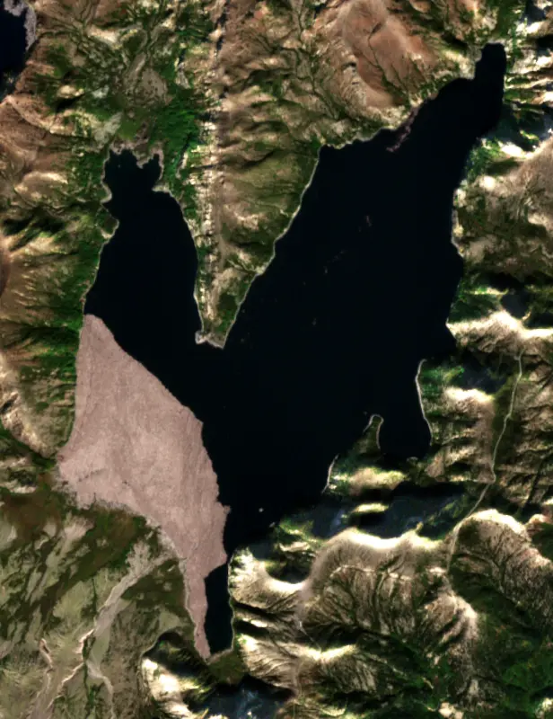
Spirit Lake lies at the north foot of Mount St. Helens in Skamania County, Washington, inside the Mount St. Helens National Volcanic Monument. Before May 18, 1980, it was a mountain resort lake with lodges and youth camps on its shores. The eruption buried those shores, raised the lake about 200 feet and left it covered in floating logs, and since 1985 its level has been held down by a tunnel through a ridge.
The old lake was itself made by the volcano. About 4,000 years ago mudflows and hot ash flows from Mount St. Helens dammed the North Fork Toutle River valley, and water backed up into two arms. Settlers took the name from Native stories of spirits that haunted the lake.
Before 1980 the shore held a Boy Scout camp, a Girl Scout camp, two YMCA camps and several lodges. The best known was the Mount St. Helens Lodge, run by Harry R. Truman, who came to the lake in 1926 and built a resort of beach cabins, rental boats and lake tours. In the spring of 1980, as a bulge grew on the mountain's north side, he turned down every plea to leave. He was 83 when the eruption killed him, and his lodge lies under hundreds of feet of debris.
At 8:32 a.m. on May 18, 1980, an earthquake shook loose the north side of the mountain and set off the largest landslide in recorded history. Part of it slammed into Spirit Lake. The water was thrown up the surrounding slopes and then rushed back into the basin, carrying thousands of trees the blast had knocked down. At first logs covered more than 70 percent of the lake. Many have since sunk, but a large mat still floats and moves with the wind, gathering at the north end in spring and summer and pushed to the south side by fall.
The landslide also sealed the lake's natural outlet. The surface rose about 197 feet, and with nowhere to drain it kept climbing with rain and snowmelt, another 54 feet by August 1982. Scientists warned that the debris dam could give way and send a catastrophic flood down the Toutle, Cowlitz and Columbia rivers. That August President Reagan told federal emergency officials to prevent a breach, and a temporary pumping plant was set up to hold the lake down.
The lasting fix was a tunnel, which the U.S. Army Corps of Engineers bored through a bedrock ridge on the west side of the lake in 1984 and 1985. It runs about 8,500 feet under Harry's Ridge and empties into South Coldwater Creek, which flows through Coldwater Lake to the North Fork Toutle. It has controlled the lake level ever since, and the Forest Service, which manages the monument, is responsible for it.
The rock around the tunnel squeezes in on it, and it needed major repairs in 1995, 1996 and 2016. Repairs close the tunnel for months, and while it is shut the lake creeps up toward its highest safe level. That is why the Forest Service has studied other permanent outlets.
Right after the eruption the water was toxic, and within a month it had no oxygen. Algae returned starting in 1983, and frogs and salamanders followed. In 1993 state biologists caught the first trout found in the lake since the eruption, an 8-inch rainbow, and a year later an 18-inch one. Where they came from has never been pinned down. Spirit Lake is one of a few blast-zone lakes set aside for research, so it is not stocked and is closed to fishing. Visitors see it from trails on the ridges around it, among them the Harry Truman Trail above the Pumice Plain. Nearby Coldwater Lake is open to fishing.
Written by Lake by Lake from U.S. Geological Survey, NASA Earth Observatory, HistoryLink.org, Mount St. Helens Science and Learning Center (Are there fish in Spirit Lake?, Why is fishing not allowed in Spirit Lake?) and Wikipedia. Checked November 2026.
Spirit Lake Outlet Tunnel Dam is an earthfill dam 184 feet high and 1,000 feet long on South Coldwater Creek, completed in 1985. It belongs to Usda FS and is run for flood control. At its normal level the reservoir holds 13,000 acre-ft.
From the National Inventory of Dams (U.S. Army Corps of Engineers), NID ID WA00770. Lake or reservoir: what’s the difference?
Where the level comes from: SPIRIT LAKE AT TUNNEL AT SPIRIT LAKE, WA (U.S. Geological Survey, used on this page) and SPIRIT LAKE WEST AT SPIRIT LAKE, WA (U.S. Geological Survey).
| Lake | Miles | Level (ft) | vs full | 7 days |
|---|---|---|---|---|
| Castle Lake Live reading | 6 | 2578.39 | — | +0.23 |
| Swift Reservoir Well below full | 15 | 951.00 | −49.00 | 0.00 |
| Yale Lake Well below full | 18 | 462.00 | −28.00 | −3.00 |
| Lake Merwin Well below full | 24 | 222.00 | −17.60 | +4.00 |
| Skookumchuck Reservoir Live reading | 44 | 425.32 | — | 0.00 |
| Bull Run Reservoir No 1 Live reading | 55 | 994.73 | — | +6.65 |
Compare Spirit Lake with Castle Lake, Swift Reservoir, Yale Lake or Lake Merwin: size, level, ramps and fish side by side.
Spirit Lake is about 49 mi from Vancouver, WA, 55 mi from Gresham, OR and 56 mi from Portland, OR. See all the lakes near each city.
Spirit Lake is at 3,440.49 feet above sea level, as of Nov 19, 2026, 12:45 AM PST. It has dropped 0.24 ft in the past 7 days.
Today's level is 0.56 ft below the median for this date (3,441.05 ft), from the gauge’s long-term daily record.
Anglers 16 and older need a Washington fishing license, sold online by the Washington Department of Fish and Wildlife. Free fishing days: First weekend after the first Monday in June. Size and bag limits can be set lake by lake: check the current regulations.
Spirit Lake averages about 90 ft deep. Depth changes with the lake level.
Yes: report with bathymetric maps (before and after 1980 eruption) from the U.S. Geological Survey (1982). It is linked in the lake facts on this page. Depths on a map are measured at a reference level: subtract how far the lake is below it today.
EPA's CyAN satellite rated cyanobacteria in Spirit Lake not detected on November 9. The satellite sees open water only; blooms can be patchy, so avoid water that looks like spilled paint or pea soup and keep dogs out of scum. Swimming advisories come from Washington health and environment agencies.
Yes. 4 trails run along or near the shore, including Harmony Trail (1.1 mi), Independence Pass Trail (4.6 mi) and Smith Creek Trail (10 mi), according to OpenStreetMap.
Spirit Lake is held back by Spirit Lake Outlet Tunnel, completed in 1985 and 184 ft high, according to the National Inventory of Dams.
From the U.S. Geological Survey (SPIRIT LAKE AT TUNNEL AT SPIRIT LAKE, WA). Lake by Lake checks it every hour; the agency's own figure is always the reference, and provisional readings can be revised.
Lake levels are refreshed every hour. Texas and California reservoirs report once a day; most USGS and NOAA gauges report every 15 to 60 minutes.
Cookies for analytics With your OK we use Google Analytics and Microsoft Clarity to count visits and see how the site is used, so we can make it better. No advertising cookies. Privacy policy