Sun
- Sunrise
- 6:18 AM
- Sunset
- 4:41 PM
- First light
- 5:52 AM
- Last light
- 5:08 PM
Reservoir · Talladega County, Alabama
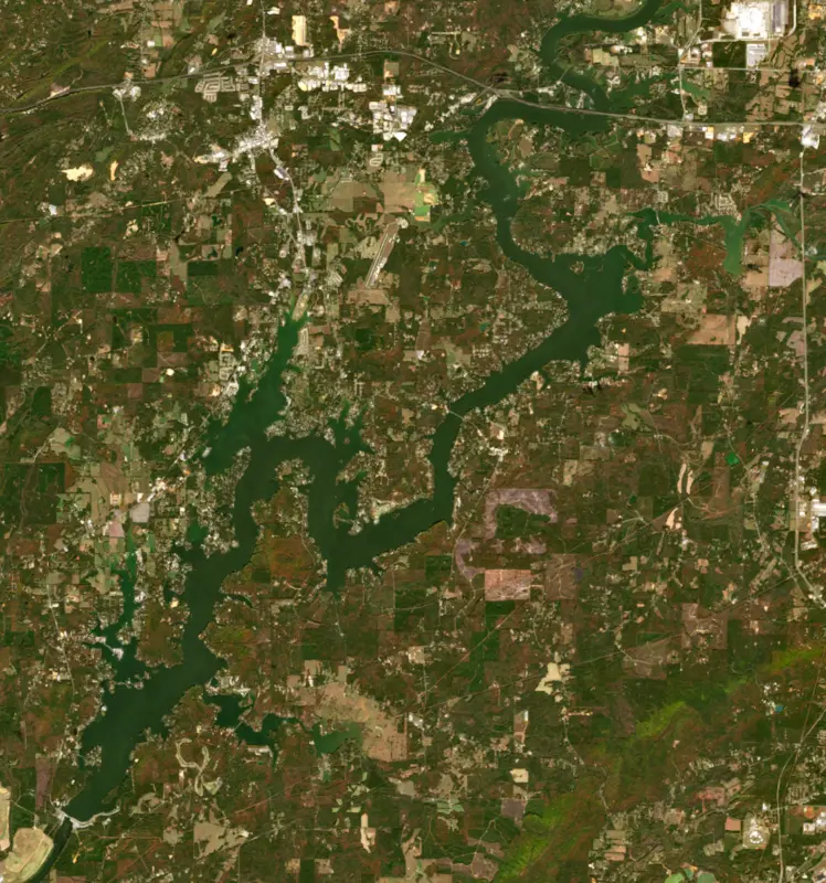
A reservoir on the Coosa in Talladega County, Alabama, held back by Logan Martin Dam since 1964.

Logan Martin Lake is at 462.62 feet above sea level — 2.38 ft below full summer pool, as of Nov 17, 2026, 8:00 PM CST. It has dropped 0.56 ft in the past 7 days.
5th lowest of 13 Alabama lakes today against full pool · See the ranking
Record low 459.37 ft (2022), record high 470.85 ft (2019) · Level history since 2017
A notification from this browser, once, when the level crosses the line (checked every hour). No account and no email. On an iPhone, add Lake by Lake to your home screen first (Share → Add to Home Screen) and open it from there. Or follow the lake in a feed reader: RSS feed.
Logan Martin Lake is down 0.56 ft over the last 7 days, at 462.62 ft today.
Daily values from the NOAA National Water Prediction Service.
Logan Martin Lake is down 1.41 ft over the last 30 days, at 462.62 ft today.
Daily values from the NOAA National Water Prediction Service.
Over the past 12 months, Logan Martin Lake ranged from 461.62 ft (Jan 15, 2026) to 465.01 ft (Jun 8, 2026), a swing of 3.4 ft. Today's level is in the lower half of that range. It is 0.09 ft lower than on this date last year.
Daily values from the NOAA National Water Prediction Service. Why lake levels rise and fall
In the U.S. Army Corps of Engineers record, which starts in 2017, the lowest level was 459.37 ft on January 4, 2022 and the highest 470.85 ft on February 24, 2019. Today’s 462.62 ft is 3.3 ft above the record low and 8.2 ft below the record high.
Logan Martin Lake level history: every year since 2017, the lowest and highest years →
Solunar periods for Logan Martin Lake, local time. How they work
High · as of Nov 9, 2026
The satellite sees a likely bloom on part of the lake. Avoid discolored water and scum, and keep dogs out of it. About 497,000 cells/mL at the worst spot, covering 10% of the lake.
Week of Aug 16Week of Nov 1
Each bar is one week, colored by the worst reading of that week.
From the U.S. EPA's Cyanobacteria Assessment Network (CyAN), which reads the color of lakes from the Sentinel-3 satellites; it sees open water only, not coves or the shoreline. Blooms can be patchy: what you see on the water matters more. Swimming closures and health advisories come from Alabama health and environment agencies. How to read it
Surface water temperature
62°F on Nov 14, 2026
84°F · Jul 2562°F · Nov 14
22°F cooler than on Jul 25, 2026.
Estimated from Landsat 8/9 (USGS) passes on clear days: the top layer of the water, a few degrees either way. Coves and the shallows can be warmer.
Logan Martin Lake water temperature: trend, swimming and the fish →
On or near the shore of Logan Martin Lake: 7 boat ramps, 9 marinas, 22 campgrounds and 4 beaches. The lake has about 240 miles of shoreline, counting its islands.
Tap an icon for details; use two fingers (or Ctrl + scroll) to move the map. Tap a dot for details. Map and lake outline © OpenStreetMap contributors. Places from OpenStreetMap, Overture Maps and Recreation.gov. Not for navigation.
What you’ll find on the shore
← AllBoating 16
← AllFishing spots 2
← AllBeaches 4
← AllCamping 22
← AllLodging 16
← AllParks 7
← AllDining 17
No aquatic invasive species are on record for Logan Martin Lake in the USGS database. Keep it that way: clean, drain and dry your boat between lakes.
Alabama: Alabama has no clean-drain-dry law for boaters, but the state asks you to remove mud, plants and animals, drain all water and dry your boat and gear before moving them. Releasing bait or stocking any fish or aquatic organism without a permit is illegal, as is putting non-native aquatic plants into public waters. State rules
Records: USGS Nonindigenous Aquatic Species database. A species not listed may still be present.
Species with open-licensed records inside Logan Martin Lake's outline, from GBIF.org (surveys, museum collections and angler reports). A record shows a fish was found here, not how many there are now.
Spring runs up the tributaries; schools busting shad in late summer.
Water temperature sets off each spawn; the bars show the usual months at this latitude and elevation, and move with a warm or cold spring. The water is about 62°F now.
Logan Martin Lake is an Alabama Power reservoir on the Coosa River about 30 miles east of Birmingham, stretching between St. Clair and Talladega counties from Neely Henry Dam down to Logan Martin Dam near Vincent. Pell City is the nearest city. Locals call it the Lake of a Thousand Coves, and its closeness to Birmingham makes it a favorite for boating, skiing and bass fishing.
The Coosa once carried steamboats, but roads and railroads took that trade away, and the river's value turned to power. Logan Martin was the second dam in Alabama Power's program of the late 1950s and 1960s to further develop the Coosa, which also brought Weiss, Henry and Bouldin dams and the rebuilding of Lay Dam. While it was being planned it went by the name Kelly Creek. Work began in 1960, and in the first month of construction the company's board named it for William Logan Martin Jr. Born in Scottsboro in 1883, Martin graduated from West Point, served as Alabama's attorney general from 1915 to 1919 and as a circuit judge in Montgomery, then spent decades as the company's top lawyer. His older brother, Thomas W. Martin, was a founder and longtime president of Alabama Power, and Lake Martin on the Tallapoosa is named for him. Logan Martin died in 1959, the year before work started. The dam went into service on August 10, 1964, with three generators rated together at 128,250 kilowatts.
The lake changes character along its length. The upper end, below Neely Henry Dam, behaves much like a river. From the Interstate 20 bridge down to the dam it opens into wide water with many sloughs and creeks. Logan Martin is a storage lake, held at summer pool through the recreation season and drawn down in late fall and winter to make room for flood water. In 2021 the Army Corps of Engineers approved Alabama Power's request to raise the normal winter level by 2 feet, from 460 to 462 feet. Next to the dam, Double Cove Park has picnic pavilions and a fishing pier, and the nearby Double Cove Trail day-use area adds hiking, a playground and a protected swimming area. Below the dam the water can rise quickly and run with strong currents when water is released, so use care in the tailrace.
State biologists say Logan Martin's spotted bass are some of the best in Alabama, with plenty in the 14- to 21-inch range and growth rated good to excellent. Largemouth grow fast too, and the lake has hosted national bass tournaments. Crappie bite best in early spring and fall. Striped, hybrid and white bass run upriver every spring to the tailwater below Neely Henry Dam, and fishing there picks up in March and can last into summer when water is released for power. In hot weather stripers and hybrids gather in spring-fed creeks such as Ohatchee and Choccolocco. Choccolocco Creek also carries the lake's hardest history. A former Monsanto plant in Anniston made PCBs from 1929 to 1971, and sampling that began in 1999 found them in the creeks that drain toward the lake. Fish consumption advisories now cover Choccolocco Creek and a long reach of the Coosa that includes this lake, so check Alabama's current advisories before keeping fish to eat.
Written by Lake by Lake from Alabama Power Shorelines (Logan Martin, Winter pool levels will be raised at Weiss and Logan Martin lakes), Encyclopedia of Alabama, Alabama Department of Conservation and Natural Resources, U.S. Geological Survey, Columbia Environmental Research Center and Wikipedia. Checked November 2026.
Logan Martin Dam is a concrete gravity dam 97 feet high and 6,076 feet long on the Coosa, completed in 1964. It belongs to Alabama Power Company and is run for hydropower, recreation, water supply and flood control. At its normal level the reservoir holds 273,000 acre-ft, drained from 7,700 square miles of land.
From the National Inventory of Dams (U.S. Army Corps of Engineers), NID ID AL01417. Lake or reservoir: what’s the difference?
Where the level comes from: Coosa River at Logan Martin Dam (NOAA National Water Prediction Service).
| Lake | Miles | Level (ft) | vs full | 7 days |
|---|---|---|---|---|
| Neely Henry Lake At or near full pool | 31 | 506.77 | −1.23 | −0.30 |
| Lay Lake At or near full pool | 33 | 395.68 | −0.32 | −0.09 |
| Lake Mitchell At or near full pool | 42 | 311.39 | −0.61 | +0.12 |
| Lake Wedowee Below full | 43 | 786.74 | −6.26 | −0.83 |
| Jordan Lake At or near full pool | 55 | 251.45 | −0.55 | +0.12 |
| Lake Martin Below full | 56 | 483.63 | −7.37 | −0.76 |
Compare Logan Martin Lake with Neely Henry Lake, Lay Lake, Lake Mitchell or Lake Wedowee: size, level, ramps and fish side by side.
Logan Martin Lake is about 28 mi from Birmingham, AL and 70 mi from Tuscaloosa, AL. See all the lakes near each city.
Logan Martin Lake is at 462.62 feet above sea level — 2.38 ft below full summer pool, as of Nov 17, 2026, 8:00 PM CST. It has dropped 0.56 ft in the past 7 days.
Logan Martin Lake's full summer pool is 465.00 ft, according to Alabama Power. Today the lake is 2.38 ft below that mark.
459.37 ft, on January 4, 2022, in the U.S. Army Corps of Engineers record, which starts in 2017. Today the lake is 3.3 ft above that.
470.85 ft, on February 24, 2019, in the U.S. Army Corps of Engineers record since 2017. That is 5.9 ft above full summer pool.
Logan Martin Lake has 7 boat ramps on our map, including Boat ramp at Coosa Island Marina, Boat ramp near High Cotton Campground , Boat ramp near Lakeside Landing RV Park & Marina, and 9 marinas. Low water can close ramps, so check today's level above and the operator before you go.
Yes. There are 22 campgrounds and RV parks within about a mile of the shore, such as Paradise Island RV Park, Knox Landing Campgrounds, Blue Eye Point RV Park.
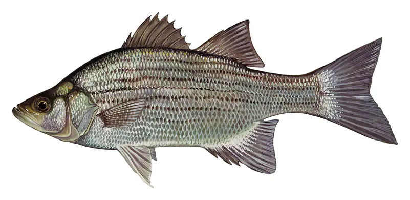
Game fish recorded in Logan Martin Lake include white bass, redspotted sunfish. In all, 12 fish species have open records inside the lake on GBIF.
The surface of Logan Martin Lake was about 62°F on November 14, estimated from a satellite pass on a clear day. It is the top layer of the water, a few degrees either way; coves and shallows run warmer in the sun.
Anglers 16 and older need an Alabama fishing license, sold online by the Alabama Department of Conservation and Natural Resources. Free fishing days: One Saturday in June (2026: June 13). Size and bag limits can be set lake by lake: check the current regulations.
NOAA's flood categories for the Logan Martin Lake gauge: action stage at 465.5 ft, minor flooding at 467.0 ft, moderate flooding at 470.0 ft and major flooding at 475.0 ft. Today the lake is 4.38 ft below the first flooding level.
Logan Martin Lake averages about 18 ft deep. Depth changes with the lake level.
In summer a white Secchi disk lowered into Logan Martin Lake stays visible to about 3.3 ft (the median of 196 readings, 2016–2025, by Alabama Water Watch and ALABAMA DEPT. OF ENVIRONMENTAL MANAGEMENT - WATER QUALITY DATA): somewhat murky water. With the algae measured too (chlorophyll about 20 µg/L), that makes it eutrophic: rich in nutrients, greener water. Clarity drops after storms and during algae blooms.
boating (7 boat ramps and 9 marinas), fishing (2 game fish), swimming (4 beaches and swimming areas), camping (22 campgrounds), cabins & lodging (16 places to stay close to the water) and parks & picnics (7 parks on the shore), according to our map of the shore.
EPA's CyAN satellite rated cyanobacteria in Logan Martin Lake high on November 9. The satellite sees open water only; blooms can be patchy, so avoid water that looks like spilled paint or pea soup and keep dogs out of scum. Swimming advisories come from Alabama health and environment agencies.
Logan Martin Lake is held back by Logan Martin, completed in 1964 and 97 ft high, according to the National Inventory of Dams.
From the NOAA National Water Prediction Service (Coosa River at Logan Martin Dam). Lake by Lake checks it every hour; the agency's own figure is always the reference, and provisional readings can be revised.
Lake levels are refreshed every hour. Texas and California reservoirs report once a day; most USGS and NOAA gauges report every 15 to 60 minutes.