Sun
- Sunrise
- 6:56 AM
- Sunset
- 5:17 PM
- First light
- 6:30 AM
- Last light
- 5:44 PM
Reservoir · Gila County, Arizona
A reservoir on the Gila River in Gila County, Arizona, held back by Coolidge Dam since 1931. Also called San Carlos Reservoir.

San Carlos Lake is at 2,450.24 feet above sea level — 60.76 ft below full pool, as of Nov 19, 2026, 3:30 AM MST. It has risen 1.53 ft in the past 7 days.
Lowest of 6 Arizona lakes today against full pool · See the ranking
A notification from this browser, once, when the level crosses the line (checked every hour). No account and no email. On an iPhone, add Lake by Lake to your home screen first (Share → Add to Home Screen) and open it from there. Or follow the lake in a feed reader: RSS feed.
San Carlos Lake is up 1.53 ft over the last 7 days, at 2,450.24 ft today.
Daily values from the NOAA National Water Prediction Service.
San Carlos Lake is up 29.73 ft over the last 30 days, at 2,450.24 ft today.
Daily values from the NOAA National Water Prediction Service. Why lake levels rise and fall
Solunar periods for San Carlos Lake, local time. How they work
Not detected · as of Nov 9, 2026
The satellite found no cyanobacteria at the surface.
Week of Aug 9Week of Nov 1
Each bar is one week, colored by the worst reading of that week.
From the U.S. EPA's Cyanobacteria Assessment Network (CyAN), which reads the color of lakes from the Sentinel-3 satellites; it sees open water only, not coves or the shoreline. Blooms can be patchy: what you see on the water matters more. Swimming closures and health advisories come from Arizona health and environment agencies. How to read it
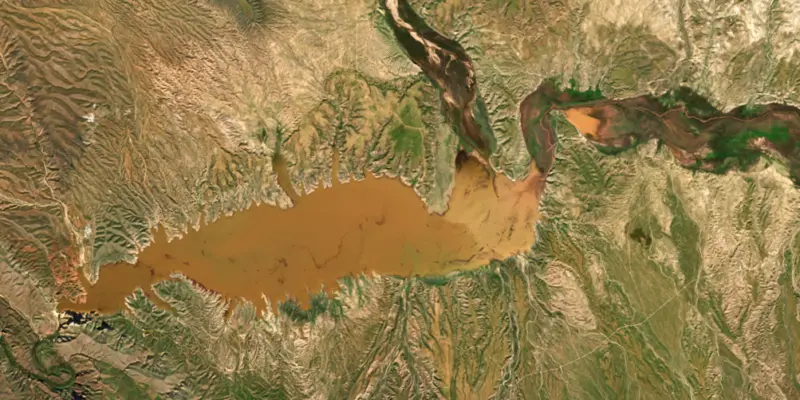
Surface water temperature
63°F on Nov 7, 2026
77°F · Oct 563°F · Nov 7
14°F cooler than on Oct 5, 2026.
Estimated from Landsat 8/9 (USGS) passes on clear days: the top layer of the water, a few degrees either way. Coves and the shallows can be warmer.
San Carlos Lake water temperature: trend, swimming and the fish →
What you’ll find on the shore
No aquatic invasive species are on record for San Carlos Lake in the USGS database. Keep it that way: clean, drain and dry your boat between lakes.
Arizona: When leaving waters listed as having invasive species (such as Lakes Mead, Mohave, Havasu and Powell and the lower Colorado River) you must remove plants, mud and animals, drain all water and keep drain plugs out while transporting. Boats kept on a listed water for 6 or more days must get a free professional decontamination before they are moved. State rules
Records: USGS Nonindigenous Aquatic Species database. A species not listed may still be present.
Species with open-licensed records inside San Carlos Lake's outline, from GBIF.org (surveys, museum collections and angler reports). A record shows a fish was found here, not how many there are now.
Shallow, protected flats in spring; docks, grass and deep edges in summer heat.
Brush piles, docks and bridge pilings; shallow for a few weeks in spring.
Channel edges and river arms; best after dark in summer, and after a rain.
Beds in shallow, firm bottoms; around docks and weeds all summer.
Shallow, muddy bays and flooded grass in spring; mud flats and inflows in summer.
Water temperature sets off each spawn; the bars show the usual months at this latitude and elevation, and move with a warm or cold spring. The water is about 63°F now.
San Carlos Lake is the reservoir behind Coolidge Dam on the Gila River, in the desert hills southeast of Globe, Arizona. It lies entirely within the San Carlos Apache Indian Reservation and spreads across parts of Gila, Graham and Pinal counties. When it is full it is one of the largest lakes in the state, but it is built to store irrigation water, and in dry years it shrinks to a fraction of that size.
The dam grew out of a long injustice downstream. As upstream farmers diverted more and more of the Gila, the Akimel O'odham, or Pima, on the Gila River reservation lost the water that had fed their fields, and many farms were abandoned. Congress passed the San Carlos Irrigation Project act in June 1924, after Senator Henry Ashurst and Representative Carl Hayden met with President Calvin Coolidge and agreed the dam would bear his name. He signed the bill that same day. The project split its land and water between the Pima and non-Indian growers around Florence and Casa Grande.
Engineers C.R. Olberg and Hermann Neuffer designed a concrete dam with three domes braced by buttresses, an unusual multiple-dome design. Work on the dam began on April 14, 1927, and it began holding water on November 15, 1928. Coolidge dedicated it on March 4, 1930. The humorist Will Rogers, seeing grass growing across the still-empty basin, joked that if the lake were his he would mow it. A small hydroelectric plant ran from 1935 until a flood in 1983 put it out of service. The dam was listed on the National Register of Historic Places in 1981 and was strengthened between 1991 and 1995. In 1993, with that work underway, record rains filled the lake and the dam released far more water than it had been expected to handle, and it held.
The reservation was created in 1871 around the meeting of the San Carlos River and the Gila. The Apache opposed the dam, fearing for their treaty rights. In 1929 the rising water flooded San Carlos, the reservation's headquarters town, and the headquarters moved up the San Carlos River to the village of Rice, which later took the name San Carlos. Tribal burial grounds were also in the basin. Officials proposed digging up and moving the remains, but the Apache objected to disturbing their dead, so a concrete slab was poured over the main burial ground instead.
Because water is released whenever downstream farms need it, the level swings widely. Since the dam was built the lake has been nearly empty at least 20 times and full only three times, and in wet years water has spilled over the dam. Largemouth bass, black crappie, sunfish, channel catfish and flathead catfish reproduce here, trout are stocked, and the lake has produced Arizona state records for black crappie and flathead catfish. Boating, water skiing and jet skis are allowed, and Soda Canyon Point Campground sits on the north side.
The lake is run by the tribe's Recreation and Wildlife Department, and anyone who is not a tribal member needs a tribal permit to use the lake. The low-water years take a toll. In June 2026 the department closed the lake after drought and releases from the dam led to the death of all its fish. Given those swings, it is worth checking with the department on lake conditions before making the drive.
Written by Lake by Lake from University of Arizona Water Resources Research Center, Encyclopedia.com (Gale), Wikipedia (Coolidge Dam, San Carlos Lake) and AZFamily (KTVK/KPHO). Checked November 2026.
Coolidge Dam is a concrete dam 220 feet high and 920 feet long on the Gila River, completed in 1931. It belongs to BIA and is run for irrigation, recreation and flood control. At its normal level the reservoir holds 872,976 acre-ft, drained from 15,302 square miles of land.
From the National Inventory of Dams (U.S. Army Corps of Engineers), NID ID AZ10436. Lake or reservoir: what’s the difference?
Where the level comes from: Gila River at Coolidge Dam (NOAA National Water Prediction Service).
| Lake | Miles | Level (ft) | vs full | 7 days |
|---|---|---|---|---|
| Theodore Roosevelt Lake Below full | 50 | 2122.02 | −28.98 | +1.01 |
| Apache Lake At or near full pool | 55 | 1908.43 | −5.57 | 0.00 |
| Canyon Lake Well below full | 58 | 1604.46 | −56.04 | −0.41 |
| Saguaro Lake At or near full pool | 64 | 1527.64 | −1.36 | +0.26 |
| Bartlett Lake Below full | 78 | 1791.04 | −6.96 | −4.26 |
| Horseshoe Lake Slightly below full | 88 | 2017.93 | −8.07 | +3.67 |
Compare San Carlos Lake with Theodore Roosevelt Lake, Apache Lake, Canyon Lake or Saguaro Lake: size, level, ramps and fish side by side.
San Carlos Lake is also known as San Carlos Reservoir.
San Carlos Lake is at 2,450.24 feet above sea level — 60.76 ft below full pool, as of Nov 19, 2026, 3:30 AM MST. It has risen 1.53 ft in the past 7 days.
San Carlos Lake's full pool is 2,511.00 ft, according to Bureau of Reclamation. Today the lake is 60.76 ft below that mark.
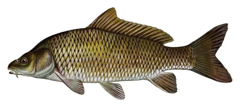
Game fish recorded in San Carlos Lake include largemouth bass, flathead catfish, channel catfish, bluegill, black crappie, common carp. In all, 14 fish species have open records inside the lake on GBIF.
The surface of San Carlos Lake was about 63°F on November 7, estimated from a satellite pass on a clear day. It is the top layer of the water, a few degrees either way; coves and shallows run warmer in the sun.
Anglers 10 and older need an Arizona fishing license, sold online by the Arizona Game and Fish Department. Free fishing days: Usually the first Saturday of National Fishing and Boating Week (June). Size and bag limits can be set lake by lake: check the current regulations.
EPA's CyAN satellite rated cyanobacteria in San Carlos Lake not detected on November 9. The satellite sees open water only; blooms can be patchy, so avoid water that looks like spilled paint or pea soup and keep dogs out of scum. Swimming advisories come from Arizona health and environment agencies.
San Carlos Lake is held back by Coolidge, completed in 1931 and 220 ft high, according to the National Inventory of Dams.
From the NOAA National Water Prediction Service (Gila River at Coolidge Dam). Lake by Lake checks it every hour; the agency's own figure is always the reference, and provisional readings can be revised.
Lake levels are refreshed every hour. Texas and California reservoirs report once a day; most USGS and NOAA gauges report every 15 to 60 minutes.
Cookies for analytics With your OK we use Google Analytics and Microsoft Clarity to count visits and see how the site is used, so we can make it better. No advertising cookies. Privacy policy