Sun
- Sunrise
- 6:47 AM
- Sunset
- 4:58 PM
- First light
- 6:20 AM
- Last light
- 5:26 PM
Reservoir · Cleburne County, Arkansas
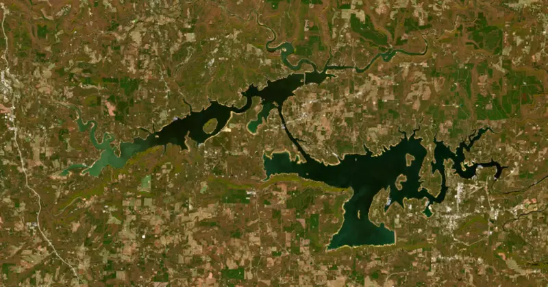
A reservoir on the Little Red in Cleburne County, Arkansas, held back by Greers Ferry Dam since 1962.

Greers Ferry Lake is at 454.54 feet above sea level — 7.50 ft below top of power pool, as of Nov 19, 2026, 3:00 AM CST. It has dropped 0.19 ft in the past 7 days.
5th lowest of 11 Arkansas lakes today against full pool · See the ranking
Record low 443.71 ft (1977), record high 486.13 ft (2008) · Level history since 1965
A notification from this browser, once, when the level crosses the line (checked every hour). No account and no email. On an iPhone, add Lake by Lake to your home screen first (Share → Add to Home Screen) and open it from there. Or follow the lake in a feed reader: RSS feed.
Greers Ferry Lake is down 0.19 ft over the last 7 days, at 454.54 ft today.
Daily values from the NOAA National Water Prediction Service.
Greers Ferry Lake is down 0.62 ft over the last 30 days, at 454.54 ft today.
Daily values from the NOAA National Water Prediction Service.
Over the past 12 months, Greers Ferry Lake ranged from 454.06 ft (Feb 6, 2026) to 462.67 ft (Jun 26, 2026), a swing of 8.6 ft. Today's level is near the bottom of that range. It is 2.18 ft lower than on this date last year.
Daily values from the NOAA National Water Prediction Service. Why lake levels rise and fall
In the U.S. Army Corps of Engineers record, which starts in 1965, the lowest level was 443.71 ft on January 20, 1977 and the highest 486.13 ft on April 13, 2008. Today’s 454.54 ft is 10.8 ft above the record low and 31.6 ft below the record high.
Greers Ferry Lake level history: every year since 1965, the lowest and highest years →
Solunar periods for Greers Ferry Lake, local time. How they work
High · as of Nov 9, 2026
The satellite sees a likely bloom on part of the lake. Avoid discolored water and scum, and keep dogs out of it. About 356,000 cells/mL at the worst spot, covering 2% of the lake.
Week of Aug 16Week of Nov 1
Each bar is one week, colored by the worst reading of that week.
From the U.S. EPA's Cyanobacteria Assessment Network (CyAN), which reads the color of lakes from the Sentinel-3 satellites; it sees open water only, not coves or the shoreline. Blooms can be patchy: what you see on the water matters more. Swimming closures and health advisories come from Arkansas health and environment agencies. How to read it
Surface water temperature
63°F on Nov 16, 2026
87°F · Jul 2963°F · Nov 16
24°F cooler than on Jul 29, 2026.
Estimated from MODIS Aqua (NASA) passes on clear days: the top layer of the water, a few degrees either way. Coves and the shallows can be warmer.
Greers Ferry Lake water temperature: trend, swimming and the fish →
On or near the shore of Greers Ferry Lake: 35 boat ramps, 12 marinas, 31 campgrounds, 2 beaches, 4 trails and 1 fishing guide. The lake has about 214 miles of shoreline, counting its islands.
Tap an icon for details; use two fingers (or Ctrl + scroll) to move the map. Tap a dot for details. Map and lake outline © OpenStreetMap contributors. Places from OpenStreetMap, Overture Maps and Recreation.gov. Not for navigation.
What you’ll find on the shore
← AllBoating 47
← AllFishing spots 6
← AllBeaches 2
← AllCamping 31
← AllLodging 24+
← AllTrails 4
← AllParks 13
← AllDining 2
Zebra mussels have been found in Greers Ferry Lake. They clog intakes and engines and spread on boats and trailers: clean, drain and dry everything before you go to another lake.
Arkansas: Pull every drain plug (bilge, livewell, baitwell and ballast) before and while trailering a boat to or from any access, a rule in force since 2021. Clean, drain and dry is urged, and possessing or moving listed invasive species such as zebra mussels is illegal. State rules
Records: USGS Nonindigenous Aquatic Species database. A species not listed may still be present.
Species with open-licensed records inside Greers Ferry Lake's outline, from GBIF.org (surveys, museum collections and angler reports). A record shows a fish was found here, not how many there are now.
Shallow, protected flats in spring; docks, grass and deep edges in summer heat.
Channel edges and river arms; best after dark in summer, and after a rain.
Rocky points, gravel and current breaks; deeper rock piles in summer.
Rocky shorelines and riprap at night in late winter; deep weed edges and humps in summer.
Run up the river arms in spring; follow shad to cool, deep water near the dam in summer.
Water temperature sets off each spawn; the bars show the usual months at this latitude and elevation, and move with a warm or cold spring. The water is about 63°F now.
Greers Ferry Lake is an Army Corps of Engineers reservoir on the Little Red River in the Ozark foothills of north-central Arkansas, spread across Cleburne and Van Buren counties about 60 miles north of Little Rock. The dam stands just north of Heber Springs. The lake is known for big walleye and hybrid striped bass, and for the trout river that runs out below the dam.
The Little Red flooded farms downstream almost every year and added to floods on the White River, and the Flood Control Act of 1938 put the White River basin on the Corps' list. Greers Ferry was the last of five dams the Corps built in that basin, after Norfork, Bull Shoals and Table Rock, and alongside Beaver. Work on the concrete dam at the foot of Round Mountain ran from 1959 to 1962 and cost $46.5 million, and commercial power generation began in July 1964. The name comes from a ferry that once crossed the river near the dam site. President John F. Kennedy dedicated the dam on October 3, 1963, in one of his last major public appearances before his death, and the John F. Kennedy park and overlook at the lake carry his name. The lake drowned much of the county's best bottomland. Families were moved, and the communities of Miller, Higden, Shiloh and Edgemont went under, though Higden was later rebuilt on higher ground and its cemeteries were relocated. Many people opposed the dam, but no citizen protest had ever stopped a Corps reservoir.
The lake is really two lakes, an upper and a lower basin, joined by a flooded gorge called the Narrows. Heber Springs sits near the dam. The Corps runs a long list of parks around the shore, among them Dam Site, Heber Springs, Mill Creek, Devils Fork, Cove Creek, Shiloh, Sugar Loaf, Narrows and Choctaw, and marinas operate at places such as Eden Isle, Fairfield Bay, Narrows and Hill Creek. The best-known hike starts from a boat. Sugar Loaf Mountain is a sandstone island rising about 540 feet out of the lake, and a loop trail built by Corps staff circles it past bluffs, then climbs on wooden steps set into cracks in the rock to the summit. It was certified as a National Recreation Trail in 1971. In spring 2008 heavy rains pushed the lake to a record high and closed many campsites.
Greers Ferry has produced two fish that the state lists as world records. Al Nelson of Higden caught a 22-pound, 11-ounce walleye here on March 12, 1982, still the Arkansas record and a 12-pound line-class world record. Jerald Shaum's 27-pound, 5-ounce hybrid striped bass from April 1997 is the other. The state record lake trout, 11 pounds 5 ounces, also came out of the lake in 1997.
Cold water released from the dam made the Little Red unsuited to its native fish, so Arkansas Game and Fish began stocking rainbow trout in 1966 and added brown trout in 1977. The browns now reproduce in the river, and the tailwater runs about 30 miles through central Arkansas. A 40-pound, 4-ounce brown caught by Howard Collins of Heber Springs on May 9, 1992, still stands as a line-class world record. The U.S. Fish and Wildlife Service runs the Greers Ferry National Fish Hatchery below the dam, which raises mainly rainbow trout. Anglers need a trout permit, and the rules on the river change from time to time. The lake also started a habit that spread statewide. In 1970 volunteers cleaned its shoreline on the weekend after Labor Day, the cleanup became yearly, it inspired the first Great Arkansas Cleanup in 1979, and in 1984 it served as the model for the first National Public Lands Day.
Written by Lake by Lake from CALS Encyclopedia of Arkansas, U.S. Army Corps of Engineers, Arkansas Game and Fish Commission (Greers Ferry Tailwater, Arkansas State Record Fish), National Recreation Trails Program and Wikipedia. Checked November 2026.
Activities listed by the U.S. Army Corps of Engineers: Boating · Camping · Fishing · Hiking · Picnicking · Visitor center · Water sports · Wildlife viewing
Greers Ferry Dam is a concrete dam 243 feet high and 1,704 feet long on the Little Red, completed in 1962. It belongs to the U.S. Army Corps of Engineers (Little Rock District) and is run for flood control, irrigation, fish and wildlife, recreation, hydropower and water supply. At its normal level the reservoir holds 1.91 million acre-ft, drained from 1,146 square miles of land.
From the National Inventory of Dams (U.S. Army Corps of Engineers), NID ID AR00173. Lake or reservoir: what’s the difference?
Where the level comes from: Little Red River at Greers Ferry Dam (NOAA National Water Prediction Service).
| Lake | Miles | Level (ft) | vs full | 7 days |
|---|---|---|---|---|
| Norfork Lake Slightly below full | 52 | 550.91 | −2.84 | −0.88 |
| Bull Shoals Lake Below full | 67 | 652.21 | −6.79 | −0.26 |
| Lake Dardanelle At or near full pool | 69 | 337.73 | −0.27 | −0.05 |
| Nimrod Lake At or near full pool | 77 | 341.49 | −0.51 | −0.13 |
Compare Greers Ferry Lake with Norfork Lake, Bull Shoals Lake, Lake Dardanelle or Nimrod Lake: size, level, ramps and fish side by side.
Greers Ferry Lake is about 59 mi from Little Rock, AR. See all the lakes near each city.
Greers Ferry Lake is at 454.54 feet above sea level — 7.50 ft below top of power pool, as of Nov 19, 2026, 3:00 AM CST. It has dropped 0.19 ft in the past 7 days.
Greers Ferry Lake's top of power pool is 462.04 ft, according to U.S. Army Corps of Engineers, Little Rock District. Today the lake is 7.50 ft below that mark.
Today's level is 2.10 ft below the median for this date (456.64 ft), from the gauge’s long-term daily record.
443.71 ft, on January 20, 1977, in the U.S. Army Corps of Engineers record, which starts in 1965. Today the lake is 10.8 ft above that.
486.13 ft, on April 13, 2008, in the U.S. Army Corps of Engineers record since 1965. That is 24.1 ft above top of power pool.
Greers Ferry Lake has 35 boat ramps on our map, including Fairfield Bay Boating Access, Heber Springs Boat Ramp, Mill Creek Boat Ramp, and 12 marinas. Low water can close ramps, so check today's level above and the operator before you go.
Yes. There are 31 campgrounds and RV parks within about a mile of the shore, such as Old Hwy 25 Campground, Old Highway 25 Recreation Areas, Devil's Fork Park.
Game fish recorded in Greers Ferry Lake include rainbow trout, largemouth bass, brown trout, lake trout, blue catfish, walleye. In all, 14 fish species have open records inside the lake on GBIF.
The surface of Greers Ferry Lake was about 63°F on November 16, estimated from a satellite pass on a clear day. It is the top layer of the water, a few degrees either way; coves and shallows run warmer in the sun.
Anglers 16 and older need an Arkansas fishing license, sold online by the Arkansas Game and Fish Commission. Free fishing days: Free Fishing Weekend in June (2026: June 12-14); no trout permit needed either. Size and bag limits can be set lake by lake: check the current regulations.
Greers Ferry Lake averages about 61 ft deep. Depth changes with the lake level.
U.S. Army Corps of Engineers lists boating, camping, fishing, hiking, picnicking, visitor center, water sports and wildlife viewing at Greers Ferry Lake. 10 campgrounds can be booked on Recreation.gov.
EPA's CyAN satellite rated cyanobacteria in Greers Ferry Lake high on November 9. The satellite sees open water only; blooms can be patchy, so avoid water that looks like spilled paint or pea soup and keep dogs out of scum. Swimming advisories come from Arkansas health and environment agencies.
Yes. 4 trails run along or near the shore, including Sugar Loaf Mountain Trail (1.8 mi), Sandy Beach Trail (1.3 mi) and Jeff Anderson Memorial Trail (0.6 mi), according to OpenStreetMap.
Greers Ferry Lake is held back by Greers Ferry Dam, completed in 1962 and 243 ft high, according to the National Inventory of Dams.
From the NOAA National Water Prediction Service (Little Red River at Greers Ferry Dam). Lake by Lake checks it every hour; the agency's own figure is always the reference, and provisional readings can be revised.
Lake levels are refreshed every hour. Texas and California reservoirs report once a day; most USGS and NOAA gauges report every 15 to 60 minutes.
Cookies for analytics With your OK we use Google Analytics and Microsoft Clarity to count visits and see how the site is used, so we can make it better. No advertising cookies. Privacy policy




