Sun
- Sunrise
- 7:33 AM
- Sunset
- 5:29 PM
- First light
- 7:04 AM
- Last light
- 5:57 PM
Reservoir · Monroe County, Indiana
A reservoir on Salt Creek in Monroe County, Indiana, held back by Monroe Dam since 1965. Also called Lake Monroe.

Monroe Lake is at 537.34 feet above sea level — 0.66 ft below top of conservation pool, as of Nov 19, 2026, 12:25 AM EST. It has dropped 0.13 ft in the past 7 days.
3rd fullest of 10 Indiana lakes today against full pool · See the ranking
Record low 533.65 ft (2005), record high 557.22 ft (2011) · Level history since 2002
A notification from this browser, once, when the level crosses the line (checked every hour). No account and no email. On an iPhone, add Lake by Lake to your home screen first (Share → Add to Home Screen) and open it from there. Or follow the lake in a feed reader: RSS feed.
Monroe Lake is down 0.13 ft over the last 7 days, at 537.34 ft today.
Daily values from the U.S. Geological Survey.
Monroe Lake is down 0.48 ft over the last 30 days, at 537.34 ft today.
Daily values from the U.S. Geological Survey.
Over the past 12 months, Monroe Lake ranged from 537.36 ft (Nov 17, 2026) to 551.08 ft (May 30, 2026), a swing of 13.7 ft. Today's level is the lowest of the past 12 months. It is 0.21 ft lower than on this date last year.
Daily values from the U.S. Geological Survey. Why lake levels rise and fall
In the U.S. Army Corps of Engineers record, which starts in 2002, the lowest level was 533.65 ft on November 13, 2005 and the highest 557.22 ft on May 4, 2011. Today’s 537.34 ft is 3.7 ft above the record low and 19.9 ft below the record high.
Monroe Lake level history: every year since 2002, the lowest and highest years →
Solunar periods for Monroe Lake, local time. How they work
High · as of Nov 9, 2026
The satellite sees a likely bloom on part of the lake. Avoid discolored water and scum, and keep dogs out of it. About 302,000 cells/mL at the worst spot, covering less than 1% of the lake.
Week of Aug 9Week of Nov 1
Each bar is one week, colored by the worst reading of that week.
From the U.S. EPA's Cyanobacteria Assessment Network (CyAN), which reads the color of lakes from the Sentinel-3 satellites; it sees open water only, not coves or the shoreline. Blooms can be patchy: what you see on the water matters more. Swimming closures and health advisories come from Indiana health and environment agencies. How to read it
Surface water temperature
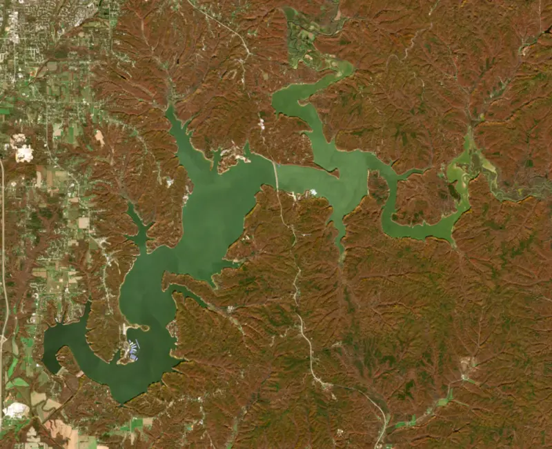
63°F on Nov 5, 2026
80°F · Jul 2463°F · Nov 5
17°F cooler than on Jul 24, 2026.
Estimated from Landsat 8/9 (USGS) passes on clear days: the top layer of the water, a few degrees either way. Coves and the shallows can be warmer.
Monroe Lake water temperature: trend, swimming and the fish →
On or near the shore of Monroe Lake: 12 boat ramps, 6 marinas, 3 rental outfits, 13 campgrounds, 2 beaches, 2 fishing piers and 12 trails. The lake has about 120 miles of shoreline, counting its islands.
Tap an icon for details; use two fingers (or Ctrl + scroll) to move the map. Tap a dot for details. Map and lake outline © OpenStreetMap contributors. Places from OpenStreetMap, Overture Maps and Recreation.gov. Not for navigation.
What you’ll find on the shore
← AllBoating 18
← AllRentals & tours 3
← AllFishing spots 2
← AllBeaches 2
← AllCamping 13
← AllLodging 8
← AllTrails 12
← AllParks 11
← AllDining 2
These invasive plants and animals have been recorded in Monroe Lake: clean, drain and dry everything before you go to another lake.
Indiana: Indiana has no clean-drain-dry law, but the DNR asks boaters to remove plants and mud, drain the motor, livewell and bilge on land, and dry gear for five days. It's illegal to transport any of 30 listed invasive aquatic plants, such as Eurasian watermilfoil, including on a boat or trailer. State rules
Records: USGS Nonindigenous Aquatic Species database. A species not listed may still be present.
Species with open-licensed records inside Monroe Lake's outline, from GBIF.org (surveys, museum collections and angler reports). A record shows a fish was found here, not how many there are now.
Brush piles, docks and bridge pilings; shallow for a few weeks in spring.
Channel edges and river arms; best after dark in summer, and after a rain.
Beds in shallow, firm bottoms; around docks and weeds all summer.
Shallow, muddy bays and flooded grass in spring; mud flats and inflows in summer.
Water temperature sets off each spawn; the bars show the usual months at this latitude and elevation, and move with a warm or cold spring. The water is about 63°F now.
Monroe Lake, which most people call Lake Monroe, is an Army Corps of Engineers reservoir on Salt Creek southeast of Bloomington, spreading across Monroe and Brown counties in the hills of southern Indiana. It is the largest man-made lake in the state, the source of Bloomington's drinking water, and the place where Indiana brought back its bald eagles.
The Corps began work in 1960 to hold back floods on Salt Creek and the White River downstream and to give Bloomington a water supply. The land was taken by eminent domain, including the whole farming village of Elkinsville, and the houses were torn down and families moved away. Eight cemeteries lay in the way. The Corps identified nearly 400 graves and documented moving just over 300 of them, and seven of the eight cemeteries were found and emptied. The eighth, a family burial ground on the old Cutright farm, was never located, and descendants believe six members of the family still lie under the water. The Corps dedicated the dam on October 24, 1964, at a cost of $16.5 million, and the lake filled in 1965. Bloomington began drawing its drinking water from it in 1967, replacing Lake Griffy.
The State Road 446 causeway splits the lake into two parts. The upper basin is shallow and takes in about 90 percent of the runoff that reaches the lake, which makes it the murkier of the two. The lower basin is deeper and holds more oxygen, which lets fish live a few feet farther down. The Department of Natural Resources runs state recreation areas around the shore, including Paynetown and Fairfax, and Cutright, a boat launch and campsite that still carries the old family's name. The Hoosier National Forest has another boat ramp at its Hardin Ridge Recreation Area. South of the lake lies the Charles C. Deam Wilderness, whose northern edge is the shoreline. Congress set it aside on December 22, 1982, and it is the only designated wilderness in Indiana. Farms and country roads once covered that ground, and it is slowly going back to hardwood forest, with 36 miles of trails for hikers and riders. Because the reservoir rises and falls with flood storage, some lakeside campsites in the wilderness can go underwater for a while.
Indiana's bald eagle comeback started here. In 1985 the state's new nongame wildlife program began raising young eagles brought from Wisconsin and Alaska in a 25-foot nest tower in a quiet bay of the lake, feeding and watching them until they could fly. Seventy-three eaglets were released by 1989. In 1991 eagles nested successfully at Monroe Lake and at Cagles Mill Lake, the first successful nests in Indiana since 1897.
State biologists list crappie, black bass, panfish, channel catfish and hybrid striped bass as the lake's best fishing. White and black crappie and bluegill are abundant, and largemouth, spotted and smallmouth bass are among the fish anglers chase most. Channel catfish up to 25 inches turned up in the 2022 state survey. The state stocks walleye and hybrid striped bass every year. Aquatic plants are sparse, and the state lists no outboard motor restrictions.
Written by Lake by Lake from Indiana Public Media (Are there people buried under Lake Monroe?, Indiana DNR celebrates 60th anniversary of Monroe Lake), Friends of Lake Monroe, Indiana Department of Natural Resources (Monroe Lake 2022 Status and Trends Survey, Bald eagle) and Wilderness Connect (University of Montana). Checked November 2026.
Monroe Dam is a rockfill dam 93 feet high and 1,350 feet long on Salt Creek, completed in 1965. It belongs to the U.S. Army Corps of Engineers (Louisville District) and is run for flood control, recreation and water supply. At its normal level the reservoir holds 182,250 acre-ft, drained from 441 square miles of land.
From the National Inventory of Dams (U.S. Army Corps of Engineers), NID ID IN03001. Lake or reservoir: what’s the difference?
Where the level comes from: MONROE LAKE NEAR HARRODSBURG, IN (U.S. Geological Survey, used on this page) and Salt Creek (IN) at Monroe Lake (NOAA National Water Prediction Service).
| Lake | Miles | Level (ft) | vs full | 7 days |
|---|---|---|---|---|
| Cagles Mill Lake Slightly below full | 40 | 636.34 | −3.16 | −0.63 |
| Patoka Lake At or near full pool | 41 | 536.40 | +0.40 | −0.61 |
| Eagle Creek Reservoir Live reading | 57 | 788.01 | — | −0.09 |
| Cecil M. Harden Lake Well below full | 57 | 644.97 | −17.03 | −4.18 |
| Geist Reservoir At or near full pool | 68 | 784.45 | +0.42 | −0.03 |
| Morse Reservoir At or near full pool | 78 | 808.70 | −0.74 | −0.16 |
Compare Monroe Lake with Cagles Mill Lake, Patoka Lake, Eagle Creek Reservoir or Cecil M. Harden Lake: size, level, ramps and fish side by side.
Monroe Lake is about 57 mi from Indianapolis, IN, 75 mi from Louisville, KY and 90 mi from Evansville, IN. See all the lakes near each city.
Monroe Lake is also known as Lake Monroe.
Monroe Lake is at 537.34 feet above sea level — 0.66 ft below top of conservation pool, as of Nov 19, 2026, 12:25 AM EST. It has dropped 0.13 ft in the past 7 days.
Monroe Lake's top of conservation pool is 538.00 ft, according to U.S. Army Corps of Engineers. Today the lake is 0.66 ft below that mark.
Today's level is 0.25 ft below the median for this date (537.59 ft), from the gauge’s long-term daily record.
533.65 ft, on November 13, 2005, in the U.S. Army Corps of Engineers record, which starts in 2002. Today the lake is 3.7 ft above that.
557.22 ft, on May 4, 2011, in the U.S. Army Corps of Engineers record since 2002. That is 19.2 ft above top of conservation pool.
Monroe Lake has 12 boat ramps on our map, including Allens Creek Boat Ramp, Paynetown Ramp, Fairfax Ramp, and 6 marinas. Low water can close ramps, so check today's level above and the operator before you go.
Yes. There are 13 campgrounds and RV parks within about a mile of the shore, such as Paynetown Campground, Lake Monroe Paynetown Campgrounds, Ransburg Scout Reservation.
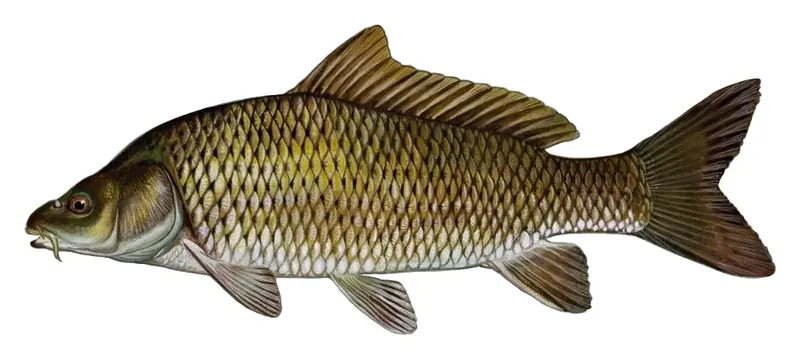
Game fish recorded in Monroe Lake include white crappie, channel catfish, bluegill, common carp. In all, 6 fish species have open records inside the lake on GBIF.
The surface of Monroe Lake was about 63°F on November 5, estimated from a satellite pass on a clear day. It is the top layer of the water, a few degrees either way; coves and shallows run warmer in the sun.
Anglers 18 and older need an Indiana fishing license, sold online by the Indiana Department of Natural Resources. Free fishing days: Four days a year for Indiana residents (2026: May 10, June 6-7 and September 26). Size and bag limits can be set lake by lake: check the current regulations.
Monroe Lake averages about 17 ft deep. Depth changes with the lake level.
In summer a white Secchi disk lowered into Monroe Lake stays visible to about 4.2 ft (the median of 90 readings, 2016–2024, by Indiana STORET and North American Lake Management Society): somewhat murky water. With the algae measured too (chlorophyll about 9 µg/L), that makes it eutrophic: rich in nutrients, greener water. Clarity drops after storms and during algae blooms.
boating (12 boat ramps and 6 marinas), kayaks, boats & jet skis (3 rental outfits on or near the water), fishing (4 game fish and 2 fishing piers and spots), swimming (2 beaches and swimming areas), hiking & walking (12 trails along the shore, the longest Pate Hollow Trail (6.7 mi)) and camping (13 campgrounds), according to our map of the shore.
EPA's CyAN satellite rated cyanobacteria in Monroe Lake high on November 9. The satellite sees open water only; blooms can be patchy, so avoid water that looks like spilled paint or pea soup and keep dogs out of scum. Swimming advisories come from Indiana health and environment agencies.
Yes. 12 trails run along or near the shore, including Monroe Trail (0.5 mi), Pate Hollow Trail (6.7 mi) and Whitehead Trail (1.4 mi), according to OpenStreetMap.
Monroe Lake is held back by Monroe Dam, completed in 1965 and 93 ft high, according to the National Inventory of Dams.
From the U.S. Geological Survey (MONROE LAKE NEAR HARRODSBURG, IN). Lake by Lake checks it every hour; the agency's own figure is always the reference, and provisional readings can be revised.
Lake levels are refreshed every hour. Texas and California reservoirs report once a day; most USGS and NOAA gauges report every 15 to 60 minutes.
Cookies for analytics With your OK we use Google Analytics and Microsoft Clarity to count visits and see how the site is used, so we can make it better. No advertising cookies. Privacy policy