Sun
- Sunrise
- 6:17 AM
- Sunset
- 4:29 PM
- First light
- 5:50 AM
- Last light
- 4:57 PM
Reservoir · Clark County, Nevada
A reservoir on the Colorado River in Arizona and Nevada, held back by Hoover Dam since 1935.

Lake Mead is at 1,041.16 feet above sea level — 187.84 ft below full pool, as of Nov 16, 2026. It has risen 1.30 ft in the past 7 days.
Record low 1,037.16 ft (2026), record high 1,225.83 ft (1983) · Level history since 1938
Which boat ramps are usable at today’s level →
A notification from this browser, once, when the level crosses the line (checked every hour). No account and no email. On an iPhone, add Lake by Lake to your home screen first (Share → Add to Home Screen) and open it from there. Or follow the lake in a feed reader: RSS feed.
Lake Mead is up 3.85 ft over the last 30 days, at 1,041.16 ft today.
Daily values from the Bureau of Reclamation.
Over the past 12 months, Lake Mead ranged from 1,037.16 ft (Oct 22, 2026) to 1,066.14 ft (Feb 28, 2026), a swing of 29.0 ft. Today's level is near the bottom of that range. It is 16.03 ft lower than on this date last year.
Daily values from the Bureau of Reclamation. Why lake levels rise and fall
In the Bureau of Reclamation record, which starts in 1938, the lowest level was 1,037.16 ft on October 22, 2026 and the highest 1,225.83 ft on July 24, 1983. Today’s 1,041.16 ft is 4.0 ft above the record low and 184.7 ft below the record high.
Lake Mead level history: every year since 1938, the lowest and highest years →
Solunar periods for Lake Mead, local time. How they work
Low · as of Nov 9, 2026
Some cyanobacteria at the surface, under 100,000 cells/mL. About 9,290 cells/mL at the worst spot, covering less than 1% of the lake.
Week of Aug 16Week of Nov 1
Each bar is one week, colored by the worst reading of that week.
From the U.S. EPA's Cyanobacteria Assessment Network (CyAN), which reads the color of lakes from the Sentinel-3 satellites; it sees open water only, not coves or the shoreline. Blooms can be patchy: what you see on the water matters more. Swimming closures and health advisories come from Nevada health and environment agencies. How to read it
Surface water temperature
70°F on Nov 12, 2026
90°F · Jul 2270°F · Nov 12
20°F cooler than on Jul 22, 2026.
Estimated from Landsat 8/9 (USGS) passes on clear days: the top layer of the water, a few degrees either way. Coves and the shallows can be warmer.
On or near the shore of Lake Mead: 7 boat ramps, 7 marinas, 5 campgrounds, 6 beaches, 1 trail and 1 fishing guide. The lake has about 477 miles of shoreline, counting its islands.
Tap an icon for details; use two fingers (or Ctrl + scroll) to move the map. Tap a dot for details. Map and lake outline © OpenStreetMap contributors. Places from OpenStreetMap, Overture Maps and Recreation.gov. Not for navigation.
What you’ll find on the shore
← AllBoating 14
Which boat ramps are usable at today’s level →
← AllRentals & tours 1
← AllFishing spots 1
← AllBeaches 6
← AllCamping 5
← AllLodging 1
← AllTrails 1
← AllParks 3
← AllDining 3
Quagga mussels have been found in Lake Mead. They clog intakes and engines and spread on boats and trailers: clean, drain and dry everything before you go to another lake.
Arizona: When leaving waters listed as having invasive species (such as Lakes Mead, Mohave, Havasu and Powell and the lower Colorado River) you must remove plants, mud and animals, drain all water and keep drain plugs out while transporting. Boats kept on a listed water for 6 or more days must get a free professional decontamination before they are moved. State rules
Nevada: Every boat that can hold water, canoes and kayaks included, must display a Nevada AIS decal, and moving quagga mussels or other invasive species is illegal (wardens can hold the boat). Clean, drain (pull the plug) and dry before going to another lake; Lake Tahoe runs its own separate boat inspections. Required: Nevada AIS decal. State rules
Records: USGS Nonindigenous Aquatic Species database. A species not listed may still be present.
Species with open-licensed records inside Lake Mead's outline, from GBIF.org (surveys, museum collections and angler reports). A record shows a fish was found here, not how many there are now.
Shallow, protected flats in spring; docks, grass and deep edges in summer heat.
Brush piles, docks and bridge pilings; shallow for a few weeks in spring.
Channel edges and river arms; best after dark in summer, and after a rain.
Run up the river arms in spring; follow shad to cool, deep water near the dam in summer.
Cool water: near the surface in spring and fall, deep in summer.
Water temperature sets off each spawn; the bars show the usual months at this latitude and elevation, and move with a warm or cold spring. The water is about 70°F now.
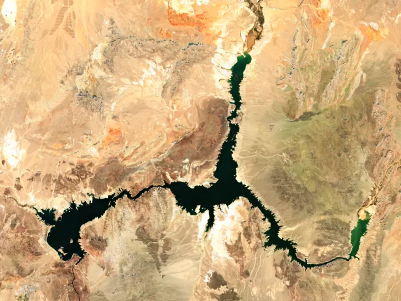
Lake Mead is the reservoir behind Hoover Dam, filling the canyons of the Colorado River where Nevada meets Arizona, about 24 miles east of Las Vegas. It holds water for millions of people in the Southwest, on tribal lands and in northern Mexico, and since 2000 its falling shoreline has become the best-known picture of drought in the West.
In 1905 the Colorado broke through an irrigation canal and ran for months into the Salton Sink, forming the Salton Sea. On December 21, 1928, Congress authorized the Boulder Canyon Project to tame the river, store irrigation water and make power. An early study favored Boulder Canyon, but the dam went into Black Canyon. Six Companies won the contract in March 1931, the river was turned into diversion tunnels in November 1932, and the first concrete was poured the following June. Water began backing up behind the dam on February 1, 1935, and Franklin D. Roosevelt dedicated it that September 30. The lake is named for Elwood Mead, who headed the Bureau of Reclamation while the dam was built. Congress made Hoover Dam the official name in 1947. The grade of the construction railroad is now the Historic Railroad Trail, which runs 3.7 miles through five tunnels above Boulder Basin.
Boulder Basin lies closest to the dam and to Las Vegas, with Hemenway Harbor and Boulder Beach on its shore, and Las Vegas Wash enters at Las Vegas Bay. The Narrows open east into Virgin Basin, and Virgin Canyon leads on to Temple Basin and Gregg Basin on the Arizona side. To the north, the long Overton Arm reaches up to where the Virgin and Muddy rivers come in. That valley held St. Thomas, founded in 1865 by Mormon settlers who thought they were still in Utah or Arizona territory. It later served travelers on the Arrowhead Trail between Los Angeles and Salt Lake City and grew to about 500 people. As the lake rose, residents left, and in 1938 Hugh Lord, one of the last, paddled away from his front door. At high water the town lay about 60 feet down. In the drought years its foundations have stood in the open at the end of a rough dirt road.
Striped bass are the fish Lake Mead is known for, and the Park Service notes occasional catches over 40 pounds. The Overton Arm, Las Vegas Bay and Temple Bar are the usual places to look. Largemouth and smallmouth bass, channel catfish, black crappie and bluegill fill out the catch, and rainbow trout are stocked at Willow Beach in the cold river below the dam. Razorback suckers and bonytail, both protected, must go back in the water. The National Park Service runs the shoreline as Lake Mead National Recreation Area, the first national recreation area in the country.
The lake last came close to full in the summers of 1983 and 1999, and a long decline followed. In August 2021 the Bureau of Reclamation declared the first shortage on the lower Colorado, cutting deliveries to Arizona, Nevada and Mexico for 2022. In July 2022 the lake dropped to its lowest point since it was first filling in 1937, and it went lower still in August 2026. Marinas at Echo Bay and Overton closed as the water fell, and the Southern Nevada Water Authority built a third, deeper intake that began delivering water in 2015. Quagga mussels were found at Las Vegas Boat Harbor in 2007 and have since spread through most of Lake Mead and Lake Mohave. Boaters must pull drain plugs when leaving the water, and boats kept at the park's marinas need an inspection and a hot-water wash before they leave the park.
Written by Lake by Lake from Bureau of Reclamation, Lower Colorado Region, National Park Service, National Park Service, Lake Mead National Recreation Area (St Thomas, Nevada, Fishing, Infestation: Quagga Mussel) and NASA Earth Observatory. Checked November 2026.
Activities listed by the National Park Service: Scenic drives · Biking · Boating · Camping · Fishing · Hiking · Horseback riding · Hunting · Picnicking · Water sports · Wildlife viewing · Paddling · Swimming
Hoover Dam is a concrete dam 730 feet high and 1,244 feet long on the Colorado River, completed in 1935. It belongs to the Bureau of Reclamation and is run for hydropower, irrigation and water supply. At its normal level the reservoir holds 28.26 million acre-ft, drained from 167,800 square miles of land.
From the National Inventory of Dams (U.S. Army Corps of Engineers), NID ID NV10122. Lake or reservoir: what’s the difference?
Where the level comes from: Lake Mead (Bureau of Reclamation, used on this page) and Lake Mead Hoover Dam and Powerplant (Bureau of Reclamation (RISE)).
| Lake | Miles | Level (ft) | vs full | 7 days |
|---|---|---|---|---|
| Lake Mohave Below full | 57 | 639.53 | −7.47 | +0.21 |
Compare Lake Mead with Lake Mohave: size, level, ramps and fish side by side.
Lake Mead is at 1,041.16 feet above sea level — 187.84 ft below full pool, as of Nov 16, 2026. It has risen 1.30 ft in the past 7 days.
Lake Mead's full pool is 1,229.00 ft, according to Bureau of Reclamation. Today the lake is 187.84 ft below that mark.
Today's level is 65.68 ft below the median for this date (1,106.84 ft), from the gauge’s long-term daily record.
1,037.16 ft, on October 22, 2026, in the Bureau of Reclamation record, which starts in 1938. Today the lake is 4.0 ft above that.
1,225.83 ft, on July 24, 1983, in the Bureau of Reclamation record since 1938.
Lake Mead has 7 boat ramps on our map, including Boat ramp near Callville Bay Marina, Hemenway Harbor, Boat ramp at Echo Bay Marina , Lake Mead, and 7 marinas. Low water can close ramps, so check today's level above and the operator before you go.
Yes. There are 5 campgrounds and RV parks within about a mile of the shore, such as Government Wash, Boulder Beach, Temple Bar RV Park.
Game fish recorded in Lake Mead include channel catfish, largemouth bass, striped bass, black crappie, rainbow trout, Coho salmon. In all, 14 fish species have open records inside the lake on GBIF.
The surface of Lake Mead was about 70°F on November 12, estimated from a satellite pass on a clear day. It is the top layer of the water, a few degrees either way; coves and shallows run warmer in the sun.
Lake Mead lies in Arizona and Nevada: the license of the state where you fish applies. Anglers 10 and older need an Arizona fishing license, sold online by the Arizona Game and Fish Department. Free fishing days: Usually the first Saturday of National Fishing and Boating Week (June). Anglers 12 and older need a Nevada fishing license, sold online by the Nevada Department of Wildlife. Free fishing days: Second Saturday in June. Size and bag limits can be set lake by lake: check the current regulations.
Lake Mead is about 531 ft deep at its deepest point, usually near the dam, and about 174 ft deep on average. Depth changes with the lake level.
Yes: reservoir survey report with contour maps from the U.S. Bureau of Reclamation (2001). It is linked in the lake facts on this page. Depths on a map are measured at a reference level: subtract how far the lake is below it today.
National Park Service lists scenic drives, biking, boating, camping, fishing, hiking, horseback riding and hunting at Lake Mead National Recreation Area. 1 campground can be booked on Recreation.gov.
EPA's CyAN satellite rated cyanobacteria in Lake Mead low on November 9. The satellite sees open water only; blooms can be patchy, so avoid water that looks like spilled paint or pea soup and keep dogs out of scum. Swimming advisories come from Nevada health and environment agencies.
Yes. A trail runs along or near the shore, including Railroad Tunnel Trail (2.5 mi), according to OpenStreetMap.
Lake Mead is held back by Hoover Dam, completed in 1935 and 730 ft high, according to the National Inventory of Dams.
From the Bureau of Reclamation (Lake Mead). Lake by Lake checks it every hour; the agency's own figure is always the reference, and provisional readings can be revised.
Lake levels are refreshed every hour. Texas and California reservoirs report once a day; most USGS and NOAA gauges report every 15 to 60 minutes.




