Sun
- Sunrise
- 7:43 AM
- Sunset
- 4:56 PM
- First light
- 7:10 AM
- Last light
- 5:29 PM
Reservoir · Stutsman County, North Dakota
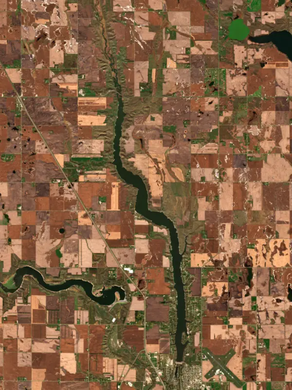
A reservoir on the James River in Stutsman County, North Dakota, held back by Jamestown Dam since 1954.
Jamestown Reservoir is at 1,429.78 feet above sea level — 1.78 ft above top of conservation pool, as of Nov 19, 2026, 4:15 AM CST. It has dropped 0.12 ft in the past 7 days.
Fullest of 8 North Dakota lakes today against full pool · See the ranking
Record low 1,420.91 ft (1993), record high 1,452.07 ft (2009) · Level history since 1960
A notification from this browser, once, when the level crosses the line (checked every hour). No account and no email. On an iPhone, add Lake by Lake to your home screen first (Share → Add to Home Screen) and open it from there. Or follow the lake in a feed reader: RSS feed.
Jamestown Reservoir is down 0.12 ft over the last 7 days, at 1,429.78 ft today.
Daily values from the NOAA National Water Prediction Service.
Jamestown Reservoir is down 0.08 ft over the last 30 days, at 1,429.78 ft today.
Daily values from the NOAA National Water Prediction Service.
Over the past 12 months, Jamestown Reservoir ranged from 1,429.31 ft (Dec 29, 2025) to 1,433.21 ft (Apr 9, 2026), a swing of 3.9 ft. Today's level is near the bottom of that range. It is 0.43 ft lower than on this date last year.
Daily values from the NOAA National Water Prediction Service. Why lake levels rise and fall
In the U.S. Army Corps of Engineers record, which starts in 1960, the lowest level was 1,420.91 ft on March 4, 1993 and the highest 1,452.07 ft on May 15, 2009. Today’s 1,429.78 ft is 8.9 ft above the record low and 22.3 ft below the record high.
Jamestown Reservoir level history: every year since 1960, the lowest and highest years →
Solunar periods for Jamestown Reservoir, local time. How they work
A bloom may be developing: look at the water before you go in and keep dogs away from scum.
From the North Dakota Department of Environmental Quality, checked Nov 19. Advisories change with the weather: check the agency's page and the signs at the water before you go.
High · as of Nov 9, 2026
The satellite sees a likely bloom on part of the lake. Avoid discolored water and scum, and keep dogs out of it. About 655,000 cells/mL at the worst spot, covering 15% of the lake.
Week of Aug 16Week of Nov 1
Each bar is one week, colored by the worst reading of that week.
From the U.S. EPA's Cyanobacteria Assessment Network (CyAN), which reads the color of lakes from the Sentinel-3 satellites; it sees open water only, not coves or the shoreline. Blooms can be patchy: what you see on the water matters more. Swimming closures and health advisories come from North Dakota health and environment agencies. How to read it
Surface water temperature
45°F on Nov 11, 2026
79°F · Jul 2245°F · Nov 11
34°F cooler than on Jul 22, 2026.
Estimated from Landsat 8/9 (USGS) passes on clear days: the top layer of the water, a few degrees either way. Coves and the shallows can be warmer.
Jamestown Reservoir water temperature: trend, swimming and the fish →
On or near the shore of Jamestown Reservoir: 4 boat ramps, 5 campgrounds and 1 beach. The lake has about 43 miles of shoreline, counting its islands.
Tap an icon for details; use two fingers (or Ctrl + scroll) to move the map. Tap a dot for details. Map and lake outline © OpenStreetMap contributors. Places from OpenStreetMap, Overture Maps and Recreation.gov. Not for navigation.
No aquatic invasive species are on record for Jamestown Reservoir in the USGS database. Keep it that way: clean, drain and dry your boat between lakes.
North Dakota: Leave every lake with no plants on boat, trailer or gear, drain all water (bilge, livewells, baitwells, motor) and pull all drain plugs, keeping them out while trailering. Don't bring live bait or aquatic plants into North Dakota, and don't haul bait in water from infested lakes. Required: ANS fee sticker (out-of-state motorboats) ($15 a year for out-of-state motorboats; $15 in North Dakota 3-year registration). State rules
Records: USGS Nonindigenous Aquatic Species database. A species not listed may still be present.
Species with open-licensed records inside Jamestown Reservoir's outline, from GBIF.org (surveys, museum collections and angler reports). A record shows a fish was found here, not how many there are now.
Rocky points, gravel and current breaks; deeper rock piles in summer.
Beds in shallow, firm bottoms; around docks and weeds all summer.
Water temperature sets off each spawn; the bars show the usual months at this latitude and elevation, and move with a warm or cold spring. The water is about 45°F now.
Jamestown Reservoir is a reservoir in Stutsman County, North Dakota. Lake by Lake tracks its level from the NOAA National Water Prediction Service and compares it with full pool and the readings of the past year.
Jamestown Dam and Reservoir are features of the PSMBP - Jamestown Dam . Located in central North Dakota the reservoir provides flood protection to areas downstream. The reservoir has approximately 2,095 water surface acres, 2,492 land acres and 45 miles of shoreline. It is located 2 miles north of Jamestown and features a modern campground and concessions, boat rental, primitive camping. Public use area open 7 days a week. Overnight camping, water, and electric hookups.
Activities listed by the Bureau of Reclamation: Biking · Boating · Camping · Fishing · Hiking · Hunting · Picnicking · Winter sports · Water sports
Jamestown Dam is an earthfill dam 81 feet high and 1,418 feet long on the James River, completed in 1954. It belongs to the Bureau of Reclamation and is run for flood control and irrigation. At its normal level the reservoir holds 35,535 acre-ft, drained from 1,574 square miles of land.
From the National Inventory of Dams (U.S. Army Corps of Engineers), NID ID ND00151. Lake or reservoir: what’s the difference?
Where the level comes from: James River at Jamestown Dam (NOAA National Water Prediction Service, used on this page) and Jamestown Dam and Reservoir (Bureau of Reclamation (RISE)).
| Lake | Miles | Level (ft) | vs full | 7 days |
|---|---|---|---|---|
| Pipestem Lake At or near full pool | 3 | 1442.89 | +0.39 | 0.00 |
| Lake Ashtabula At or near full pool | 30 | 1264.70 | −1.30 | −0.46 |
| Eastern Stump Lake Live reading | 67 | 1450.97 | — | −0.10 |
| Devils Lake Live reading | 81 | 1449.89 | — | +0.03 |
| Dry Lake Live reading | 91 | 1451.36 | — | +0.04 |
| Morrison Lake Live reading | 92 | 1459.25 | — | −0.04 |
Compare Jamestown Reservoir with Pipestem Lake, Lake Ashtabula, Eastern Stump Lake or Devils Lake: size, level, ramps and fish side by side.
Jamestown Reservoir is about 89 mi from Fargo, ND. See all the lakes near each city.
Jamestown Reservoir is at 1,429.78 feet above sea level — 1.78 ft above top of conservation pool, as of Nov 19, 2026, 4:15 AM CST. It has dropped 0.12 ft in the past 7 days.
Jamestown Reservoir's top of conservation pool is 1,428.00 ft, according to U.S. Army Corps of Engineers. Today the lake is 1.78 ft above that mark.
Today's level is 0.32 ft above the median for this date (1,429.46 ft), from the gauge’s long-term daily record.
1,420.91 ft, on March 4, 1993, in the U.S. Army Corps of Engineers record, which starts in 1960. Today the lake is 8.9 ft above that.
1,452.07 ft, on May 15, 2009, in the U.S. Army Corps of Engineers record since 1960. That is 24.1 ft above top of conservation pool.
Jamestown Reservoir has 4 boat ramps on our map, including Boat ramp at Lazy Fish at Pelican Point, Boat ramp near Stutsman County Recreation Area. Low water can close ramps, so check today's level above and the operator before you go.
Yes. There are 5 campgrounds and RV parks within about a mile of the shore, such as Lazy Fish at Pelican Point, The DAK "We Gotz it" at Smokey’s, The Meadows RV Park.
Game fish recorded in Jamestown Reservoir include smallmouth bass, bluegill. In all, 3 fish species have open records inside the lake on GBIF.
The surface of Jamestown Reservoir was about 45°F on November 11, estimated from a satellite pass on a clear day. It is the top layer of the water, a few degrees either way; coves and shallows run warmer in the sun.
Anglers 16 and older need a North Dakota fishing license, sold online by the North Dakota Game and Fish Department. Free fishing days: Residents only: first weekend in June and December 26-27. Size and bag limits can be set lake by lake: check the current regulations.
Jamestown Reservoir averages about 19 ft deep. Depth changes with the lake level.
In summer a white Secchi disk lowered into Jamestown Reservoir stays visible to about 7.2 ft (the median of 56 readings, 2021–2026, by North Dakota Department Of Environmental Quality): clear water. With the algae measured too (chlorophyll about 10 µg/L), that makes it eutrophic: rich in nutrients, greener water. Clarity drops after storms and during algae blooms.
Yes: lake contour map (overview) from the North Dakota Game and Fish Department (2020) and reservoir survey report with contour maps from the U.S. Bureau of Reclamation (2009). It is linked in the lake facts on this page. Depths on a map are measured at a reference level: subtract how far the lake is below it today.
Bureau of Reclamation lists biking, boating, camping, fishing, hiking, hunting, picnicking and winter sports at Jamestown Reservoir.
EPA's CyAN satellite rated cyanobacteria in Jamestown Reservoir high on November 9. The satellite sees open water only; blooms can be patchy, so avoid water that looks like spilled paint or pea soup and keep dogs out of scum. Swimming advisories come from North Dakota health and environment agencies.
Jamestown Reservoir is held back by Jamestown Dam, completed in 1954 and 81 ft high, according to the National Inventory of Dams.
From the NOAA National Water Prediction Service (James River at Jamestown Dam). Lake by Lake checks it every hour; the agency's own figure is always the reference, and provisional readings can be revised.
Lake levels are refreshed every hour. Texas and California reservoirs report once a day; most USGS and NOAA gauges report every 15 to 60 minutes.
Cookies for analytics With your OK we use Google Analytics and Microsoft Clarity to count visits and see how the site is used, so we can make it better. No advertising cookies. Privacy policy

