Sun
- Sunrise
- 7:29 AM
- Sunset
- 5:17 PM
- First light
- 6:59 AM
- Last light
- 5:47 PM
Reservoir · Mercer County, Ohio
A reservoir on Beaver Creek in Mercer County, Ohio, held back by Grand Lake St. Marys - West Embankment since 1841. Also called Grand Lake–Saint Marys.
Grand Lake St. Marys is at 870.78 feet above sea level, as of Nov 19, 2026, 5:15 AM EST. The level has held steady over the past week.
A notification from this browser, once, when the level crosses the line (checked every hour). No account and no email. On an iPhone, add Lake by Lake to your home screen first (Share → Add to Home Screen) and open it from there. Or follow the lake in a feed reader: RSS feed.
Grand Lake St. Marys has held steady over the last 7 days (within 0.05 ft).
Daily values from the U.S. Geological Survey.
Grand Lake St. Marys is down 0.28 ft over the last 30 days, at 870.78 ft today.
Daily values from the U.S. Geological Survey.
Over the past 12 months, Grand Lake St. Marys ranged from 869.11 ft (Dec 29, 2025) to 872.20 ft (Sep 18, 2026), a swing of 3.1 ft. Today's level is in the upper half of that range. It is 1.24 ft higher than on this date last year.
Daily values from the U.S. Geological Survey. Why lake levels rise and fall
Solunar periods for Grand Lake St. Marys, local time. How they work
Do not swim or wade there, and keep dogs out of the water.
From the Ohio Department of Health, checked Nov 19. Advisories change with the weather: check the agency's page and the signs at the water before you go.
Very high · as of Nov 9, 2026
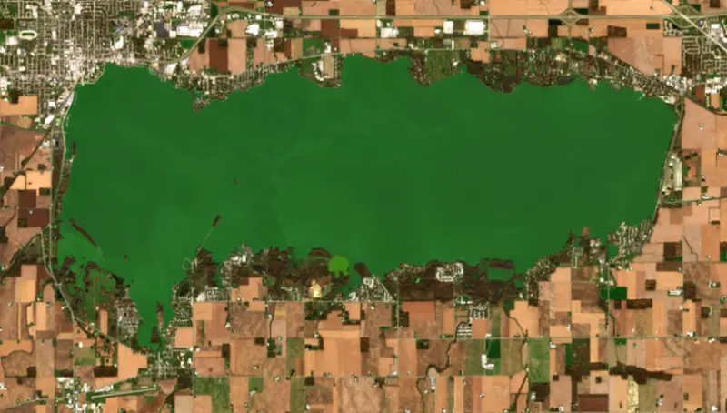
The satellite sees a strong bloom on part of the lake. Stay out of discolored water, keep pets away and check for state advisories. About 3,730,000 cells/mL at the worst spot, covering 80% of the lake.
Week of Aug 16Week of Nov 1
Each bar is one week, colored by the worst reading of that week.
From the U.S. EPA's Cyanobacteria Assessment Network (CyAN), which reads the color of lakes from the Sentinel-3 satellites; it sees open water only, not coves or the shoreline. Blooms can be patchy: what you see on the water matters more. Swimming closures and health advisories come from Ohio health and environment agencies. How to read it
Surface water temperature
47°F on Nov 16, 2026
74°F · Jul 2647°F · Nov 16
28°F cooler than on Jul 26, 2026.
Estimated from MODIS Aqua (NASA) passes on clear days: the top layer of the water, a few degrees either way. Coves and the shallows can be warmer.
Grand Lake St. Marys water temperature: trend, swimming and the fish →
On or near the shore of Grand Lake St. Marys: 14 boat ramps, 9 marinas, 1 rental outfit, 6 campgrounds, 1 beach and 1 fishing pier. The lake has about 99 miles of shoreline, counting its islands.
Tap an icon for details; use two fingers (or Ctrl + scroll) to move the map. Tap a dot for details. Map and lake outline © OpenStreetMap contributors. Places from OpenStreetMap, Overture Maps and Recreation.gov. Not for navigation.
What you’ll find on the shore
← AllBoating 23
← AllRentals & tours 1
← AllFishing spots 3
← AllBeaches 1
← AllCamping 6
← AllLodging 9
← AllParks 10
← AllDining 24+
No aquatic invasive species are on record for Grand Lake St. Marys in the USGS database. Keep it that way: clean, drain and dry your boat between lakes.
Ohio: Ohio has no clean-drain-dry law for boaters; ODNR asks you to clean, drain and dry your boat before leaving every lake and to put unused bait in the trash. Possessing, selling or releasing listed injurious invasive species such as round goby is illegal. State rules
Records: USGS Nonindigenous Aquatic Species database. A species not listed may still be present.
Species with open-licensed records inside Grand Lake St. Marys's outline, from GBIF.org (surveys, museum collections and angler reports). A record shows a fish was found here, not how many there are now.
Shallow, protected flats in spring; docks, grass and deep edges in summer heat.
Brush piles, docks and bridge pilings; shallow for a few weeks in spring.
Channel edges and river arms; best after dark in summer, and after a rain.
Beds in shallow, firm bottoms; around docks and weeds all summer.
Soft, weedy bottoms in shallow bays; bites best after dark in late spring and summer.
Water temperature sets off each spawn; the bars show the usual months at this latitude and elevation, and move with a warm or cold spring. The water is about 47°F now.
Grand Lake St. Marys is the largest inland lake in Ohio, a broad, shallow reservoir in Mercer and Auglaize counties between the cities of Celina and St. Marys, about 23 miles southwest of Lima. It was built as a water supply for a canal, it once ranked as the largest man-made lake in the world, and in recent decades it has been known for a long fight against toxic algae.
The lake was built over a swampy prairie to feed water to the Miami and Erie Canal, which connected the Ohio River with Lake Erie. The land was impounded in 1845, the same year the canal was finished at a cost to the state of $8 million. The canal did well for about 30 years before railroads took its trade, and after the Great Flood of 1913 it was abandoned for commercial use. The lake stayed. It has also been called Grand Reservoir, Lake Mercer and Lake Celina, and its official federal name is simply Grand Lake.
In the 1890s oil was found in the area, and around 1891 derricks went up in the lake itself, which is often cited as the first offshore oil drilling anywhere. Ohio made the lake one of its first state parks in 1949.
Celina sits on the northwest shore and draws its drinking water from the lake. Coldwater Creek is the main stream feeding it, along with smaller creeks such as Prairie, Burntwood, Barnes and Chickasaw, and Beaver Creek carries the outflow west. That makes the lake part of the Wabash River basin, which has its headwaters in eastern Indiana and western Ohio. There are three islands, Safety, Prentiss and Dayton, a lighthouse, and a lakeside campus of Wright State University. The lake lies on a major route for migrating birds, and bald eagles now nest around it.
Boats of any horsepower are allowed, with a no-wake zone running 300 feet out from the shore and a wildlife refuge in the southwest corner that is closed to boats. Anglers fish for crappie, yellow perch, bluegill and bass, and the state fish hatchery on the eastern shore raises saugeye, walleye, channel catfish and bass for stocking. Celina holds its Lake Festival on the last weekend of July, with one of the largest gatherings of Amphicars anywhere and a swim-in on Friday night.
The lake's trouble starts on the land around it. In a 2007 study the Ohio EPA found that more than 80 percent of the watershed was row crops and pasture, with roughly 295,400 animal units of hogs, poultry and cattle. It ranked the watershed among the 10 most impaired in Ohio, citing straightened and tiled streams, manure runoff and failing septic systems. Phosphorus feeds blue-green algae that produce microcystin, a toxin that can cause rashes, stomach illness and liver damage.
The state issued water advisories on the lake every year from 2009 on. In 2010 the toxins sickened both people and animals, and in January 2011 the watershed was declared distressed, the only one in Ohio with that label. Since 2012, wetlands and treatment trains that filter creek water before it reaches the lake have been built on Prairie, Coldwater, Beaver and Big Chickasaw creeks. By late July 2024, toxin levels were about a third of what the previous decade had seen at that time of year, though still above the state's recreational threshold. Anyone planning to swim or let a dog in the water should check the current advisory first.
Written by Lake by Lake from Ohio Environmental Protection Agency, The Daily Standard and Wikipedia (Grand Lake St. Marys State Park, Miami and Erie Canal, Celina, Ohio). Checked November 2026.
Grand Lake St. Marys - West Embankment is an earthfill dam 20 feet high and 9,760 feet long on Beaver Creek, completed in 1841. It belongs to ODNR, Division of Parks & Watercraft and is run for recreation. At its normal level the reservoir holds 62,914 acre-ft, drained from 110 square miles of land.
From the National Inventory of Dams (U.S. Army Corps of Engineers), NID ID OH00580. Lake or reservoir: what’s the difference?
Where the level comes from: Grand Lake St Marys near Celina OH (U.S. Geological Survey).
| Lake | Miles | Level (ft) | vs full | 7 days |
|---|---|---|---|---|
| Lake Loramie Live reading | 17 | 953.79 | — | −0.04 |
| Indian Lake Live reading | 37 | 996.04 | — | −0.08 |
| J. Edward Roush Lake Below full | 52 | 737.54 | −11.46 | −8.21 |
| Clarence J Brown Reservoir Slightly below full | 59 | 1009.55 | −2.45 | −0.32 |
| Salamonie Lake Well below full | 61 | 739.41 | −15.59 | −8.19 |
| Mississinewa Lake Well below full | 74 | 721.39 | −15.61 | −6.75 |
Compare Grand Lake St. Marys with Lake Loramie, Indian Lake, J. Edward Roush Lake or Clarence J Brown Reservoir: size, level, ramps and fish side by side.
Grand Lake St. Marys is about 49 mi from Fort Wayne, IN, 55 mi from Dayton, OH and 94 mi from Toledo, OH. See all the lakes near each city.
Grand Lake St. Marys is also known as Grand Lake–Saint Marys.
Grand Lake St. Marys is at 870.78 feet above sea level, as of Nov 19, 2026, 5:15 AM EST. The level has held steady over the past week.
Grand Lake St. Marys has 14 boat ramps on our map, including Boat ramp near Sandy Beach St Marys OH, Boat ramp near The St Mary's East Bank Marina, Boat ramp near Grand Lake St. Mary's Campground, and 9 marinas. Low water can close ramps, so check today's level above and the operator before you go.
Yes. There are 6 campgrounds and RV parks within about a mile of the shore, such as Rustic Haven Campground, Park Grand Resort, Kozy Kampground.
Game fish recorded in Grand Lake St. Marys include channel catfish, bluegill, largemouth bass, black crappie, white crappie, orangespotted sunfish. In all, 17 fish species have open records inside the lake on GBIF.
The surface of Grand Lake St. Marys was about 47°F on November 16, estimated from a satellite pass on a clear day. It is the top layer of the water, a few degrees either way; coves and shallows run warmer in the sun.
Anglers 16 and older need an Ohio fishing license, sold online by the Ohio Department of Natural Resources Division of Wildlife. Free fishing days: Father's Day weekend. Size and bag limits can be set lake by lake: check the current regulations.
Grand Lake St. Marys averages about 5 ft deep. Depth changes with the lake level.
Yes: fishing map with depth contours from the Ohio Department of Natural Resources, Division of Wildlife. It is linked in the lake facts on this page. Depths on a map are measured at a reference level: subtract how far the lake is below it today.
boating (14 boat ramps and 9 marinas), kayaks, boats & jet skis (1 rental outfit on or near the water), fishing (11 game fish and 1 fishing pier or spot), swimming (1 beach or swimming area), camping (6 campgrounds) and cabins & lodging (9 places to stay close to the water), according to our map of the shore.
EPA's CyAN satellite rated cyanobacteria in Grand Lake St. Marys very high on November 9. The satellite sees open water only; blooms can be patchy, so avoid water that looks like spilled paint or pea soup and keep dogs out of scum. Swimming advisories come from Ohio health and environment agencies.
Grand Lake St. Marys is held back by Grand Lake St. Marys - West Embankment, completed in 1841 and 20 ft high, according to the National Inventory of Dams.
From the U.S. Geological Survey (Grand Lake St Marys near Celina OH). Lake by Lake checks it every hour; the agency's own figure is always the reference, and provisional readings can be revised.
Lake levels are refreshed every hour. Texas and California reservoirs report once a day; most USGS and NOAA gauges report every 15 to 60 minutes.
Cookies for analytics With your OK we use Google Analytics and Microsoft Clarity to count visits and see how the site is used, so we can make it better. No advertising cookies. Privacy policy