Sun
- Sunrise
- 6:59 AM
- Sunset
- 5:33 PM
- First light
- 6:33 AM
- Last light
- 5:59 PM
Reservoir · Travis County, Texas
A reservoir on the Colorado River in Travis County, Texas, held back by Mansfield Dam since 1942.

Lake Travis is at 681.67 feet above sea level — 0.67 ft above top of conservation pool, 100.0% full, as of Nov 17, 2026. It has risen 3.72 ft in the past 7 days.
3rd fullest of 118 Texas lakes today by percent full · See the ranking
Record low 614.18 ft (1951), record high 710.31 ft (1991) · Level history since 1942
Which boat ramps are usable at today’s level →
A notification from this browser, once, when the level crosses the line (checked every hour). No account and no email. On an iPhone, add Lake by Lake to your home screen first (Share → Add to Home Screen) and open it from there. Or follow the lake in a feed reader: RSS feed.
Lake Travis is up 4.05 ft over the last 30 days, at 681.67 ft today.
Daily values from the Texas Water Development Board.
Over the past 12 months, Lake Travis ranged from 663.26 ft (Apr 19, 2026) to 684.71 ft (Jul 19, 2026), a swing of 21.5 ft. Today's level is near the top of that range. It is 13.39 ft higher than on this date last year.
Daily values from the Texas Water Development Board. Why lake levels rise and fall
In the Texas Water Development Board record, which starts in 1942, the lowest level was 614.18 ft on August 14, 1951 and the highest 710.31 ft on December 26, 1991. Today’s 681.67 ft is 67.5 ft above the record low and 28.6 ft below the record high.
Lake Travis level history: every year since 1942, the lowest and highest years →
Solunar periods for Lake Travis, local time. How they work
Not detected · as of Nov 9, 2026
The satellite found no cyanobacteria at the surface.
Week of Aug 16Week of Nov 1
Each bar is one week, colored by the worst reading of that week.
From the U.S. EPA's Cyanobacteria Assessment Network (CyAN), which reads the color of lakes from the Sentinel-3 satellites; it sees open water only, not coves or the shoreline. Blooms can be patchy: what you see on the water matters more. Swimming closures and health advisories come from Texas health and environment agencies. How to read it
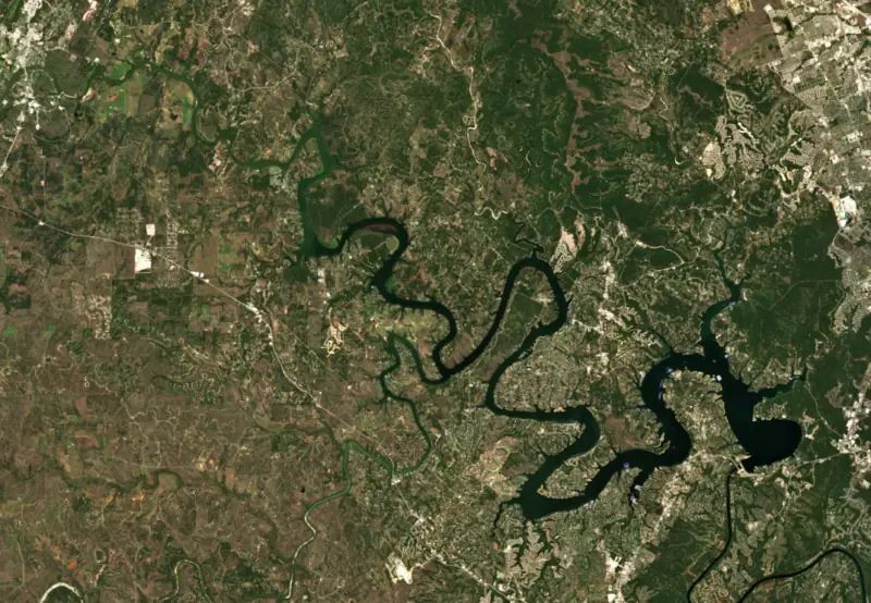
Surface water temperature
77°F on Oct 22, 2026
88°F · Jul 2677°F · Oct 22
11°F cooler than on Jul 26, 2026.
Estimated from Landsat 8/9 (USGS) passes on clear days: the top layer of the water, a few degrees either way. Coves and the shallows can be warmer.
Lake Travis water temperature: trend, swimming and the fish →
On or near the shore of Lake Travis: 23 boat ramps, 33 marinas, 40 rental outfits, 28 campgrounds, 4 beaches and 7 trails. The lake has about 279 miles of shoreline, counting its islands.
Tap an icon for details; use two fingers (or Ctrl + scroll) to move the map. Tap a dot for details. Map and lake outline © OpenStreetMap contributors. Places from OpenStreetMap, Overture Maps and Recreation.gov. Not for navigation.
What you’ll find on the shore
← AllBoating 56
Which boat ramps are usable at today’s level →
← AllRentals & tours 46
← AllFishing spots 2
← AllBeaches 4
← AllCamping 28
← AllLodging 24+
← AllTrails 7
← AllParks 20+
← AllDining 22
Zebra mussels have been found in Lake Travis. They clog intakes and engines and spread on boats and trailers: clean, drain and dry everything before you go to another lake.
Texas: Before leaving or arriving at any public fresh water, drain all water from the boat and gear, including bilge, livewells, motor and bait buckets; live bait bought from a dealer may stay in water if you carry the receipt. Remove any invasive plants clinging to the boat or trailer right away, and never move invasive species such as zebra mussels. State rules
Records: USGS Nonindigenous Aquatic Species database. A species not listed may still be present.
In the last 12 months, Texas Parks and Wildlife Department stocked 274,853 fish in Lake Travis: Florida largemouth bass (274,853).
Source: Texas Parks and Wildlife Department stocking records.
Species with open-licensed records inside Lake Travis's outline, from GBIF.org (surveys, museum collections and angler reports). A record shows a fish was found here, not how many there are now. marks fish the state stocks here.
Shallow, protected flats in spring; docks, grass and deep edges in summer heat.
Brush piles, docks and bridge pilings; shallow for a few weeks in spring.
Channel edges and river arms; best after dark in summer, and after a rain.
Rocky points, gravel and current breaks; deeper rock piles in summer.
Rocky shorelines and riprap at night in late winter; deep weed edges and humps in summer.
Water temperature sets off each spawn; the bars show the usual months at this latitude and elevation, and move with a warm or cold spring.
Lake Travis is the reservoir behind Mansfield Dam on the Colorado River, winding 65 miles through the Hill Country of Travis and Burnet counties northwest of Austin. It is the one Highland Lake built to hold back floods, and together with Lake Buchanan upstream it stores the water supply for more than a million people. Clear water, limestone cliffs and big swings in level are what most people know it for.
The dam stands at Marshall Ford, an old crossing of the Colorado. In December 1936 the U.S. Department of the Interior authorized the Lower Colorado River Authority to build a low dam there, and work began in February 1937, with the Bureau of Reclamation as LCRA's partner. Then a severe flood swept the basin in July 1938. Planners raised the design from 200 feet to 278 feet so the lake could store floodwater as well as supply water, which pushed completion to 1942. In 1941, while still under construction, it was renamed for U.S. Representative Joseph J. Mansfield.
Central Texas is what LCRA calls Flash Flood Alley, and Lake Travis is the lake that catches floodwater before it reaches Austin. Above the line LCRA treats as full for water supply, the lake has a flood pool that can hold roughly 776,000 more acre-feet before water reaches the spillway. The record high came on Christmas Day 1991, less than 4 feet below the spillway. The record low was set on Aug. 14, 1951, more than 96 feet lower.
The swings can come fast. On July 2, 2025, the region was in a drought that had lasted years. Heavy rain began the next day, and by the end of that month LCRA's two water-supply lakes were close to full again. LCRA's advice to people who live along the lakes is to watch rain far upstream, not only the weather at the lake.
Rocky banks, steep cliffs and clear water define most of the lake, with little aquatic vegetation. Large creeks and the Pedernales River enter as arms of their own.
Mansfield Dam Park sits beside the dam on the main body of the lake and has the largest public boat ramp on Lake Travis, four lanes wide. It also has an underwater park for scuba divers, with a compass course linking sunken boats and leftover dam construction materials. Pace Bend Park, in far western Travis County, covers 1,368 acres with more than nine miles of shoreline. Its west side is lined with high limestone cliffs and rocky coves known for sunsets, and the interior is kept as a wildlife preserve reached only on foot, by bicycle or on horseback. Pace Bend has no lifeguards at its swimming coves, and zebra mussels have turned up along the shoreline at Mansfield Dam Park.
Largemouth bass are plentiful but mostly small, and trophy fish are rare. Guadalupe bass, white bass, stripers, sunfish and catfish, mostly blues, round out the catch. Spring and fall are the best seasons for bass, and June through August is hard going. White bass run up the major creek arms, the Pedernales and the upper Colorado arm from about late February through May. Stripers are a lower-lake fish, found between the dam and the mouth of Sandy Creek, where they chase shad on the surface in April and May and gather around lighted docks on winter nights. Zebra mussels have been found in the lake, so Texas law requires draining boats, livewells and bait buckets before leaving, and moving the mussels is illegal.
Written by Lake by Lake from Lower Colorado River Authority (LCRA dams form the Highland Lakes, The Highland Lakes are almost full again. Now what?), Texas State Historical Association, Texas Parks and Wildlife Department and Travis County Parks (Mansfield Dam Park, Pace Bend Park). Checked November 2026.
Mansfield Dam is an earthfill dam 277 feet high and 7,089 feet long on the Colorado River, completed in 1942. It belongs to Lower Colorado River Authority and is run for flood control, irrigation, hydropower and water supply. At its normal level the reservoir holds 1.95 million acre-ft, drained from 38,130 square miles of land.
From the National Inventory of Dams (U.S. Army Corps of Engineers), NID ID TX01087. Lake or reservoir: what’s the difference?
Where the level comes from: Lake Travis (Texas Water Development Board, used on this page), LCRA Lk Travis nr Austin, TX (U.S. Geological Survey) and Colorado River (TX) at Lake Travis (NOAA National Water Prediction Service).
| Lake | Miles | Level (ft) | vs full | 7 days |
|---|---|---|---|---|
| Lake Austin At or near full pool | 9 | 492.06 | −0.74 | −0.28 |
| Mills Pond Live reading | 14 | 832.03 | — | +1.14 |
| Lake Georgetown Slightly below full | 22 | 784.97 | −6.03 | +0.42 |
| Lake Marble Falls At or near full pool | 24 | 736.41 | −0.59 | +0.69 |
| Lake LBJ At or near full pool | 28 | 824.64 | −0.36 | +0.61 |
| Inks Lake At or near full pool | 37 | 887.14 | −0.86 | −0.09 |
Compare Lake Travis with Lake Austin, Mills Pond, Lake Georgetown or Lake Marble Falls: size, level, ramps and fish side by side.
Lake Travis is about 11 mi from Austin, TX, 17 mi from Round Rock, TX and 23 mi from Georgetown, TX. See all the lakes near each city.
Lake Travis is at 681.67 feet above sea level — 0.67 ft above top of conservation pool, 100.0% full, as of Nov 17, 2026. It has risen 3.72 ft in the past 7 days.
Lake Travis's top of conservation pool is 681.00 ft, according to Texas Water Development Board. Today the lake is 0.67 ft above that mark.
Today's level is 13.19 ft above the median for this date (668.48 ft), from the gauge’s long-term daily record.
614.18 ft, on August 14, 1951, in the Texas Water Development Board record, which starts in 1942. Today the lake is 67.5 ft above that.
710.31 ft, on December 26, 1991, in the Texas Water Development Board record since 1942. That is 29.3 ft above top of conservation pool.
Lake Travis has 23 boat ramps on our map, including Boat ramp near Bob Wentz Park, Boat ramp near Kate's Cove, Bob Wentz Park (sailcraft / non-motorized only), and 33 marinas. Low water can close ramps, so check today's level above and the operator before you go.
Yes. There are 28 campgrounds and RV parks within about a mile of the shore, such as Paradise Cove RV Resort, Lago Vista Campground, Camper Resort On Lake Travis.
Game fish recorded in Lake Travis include striped bass, largemouth bass, blue catfish, bluegill, Guadalupe bass, flathead catfish. In all, 40 fish species have open records inside the lake on GBIF.
Anglers 17 and older need a Texas fishing license, sold online by the Texas Parks and Wildlife Department. Free fishing days: First Saturday in June. Size and bag limits can be set lake by lake: check the current regulations.
Lake Travis is about 210 ft deep at its deepest point, usually near the dam, and about 103 ft deep on average. Depth changes with the lake level.
In summer a white Secchi disk lowered into Lake Travis stays visible to about 8.2 ft (the median of 151 readings, 2016–2024, by Texas Commission on Environmental Quality): clear water. Silt after rain lowers the reading as much as algae do. Clarity drops after storms and during algae blooms.
Yes: hydrographic survey contour map from the Texas Water Development Board (2019). It is linked in the lake facts on this page. Depths on a map are measured at a reference level: subtract how far the lake is below it today.
boating (23 boat ramps and 33 marinas, with the ramps usable at today’s level), kayaks, boats & jet skis (40 rental outfits on or near the water), boat tours (6 boat tours and charters), fishing (27 game fish; stocked by the state), swimming (4 beaches and swimming areas) and hiking & walking (7 trails along the shore, the longest Pack Trail (2.5 mi)), according to our map of the shore.
EPA's CyAN satellite rated cyanobacteria in Lake Travis not detected on November 9. The satellite sees open water only; blooms can be patchy, so avoid water that looks like spilled paint or pea soup and keep dogs out of scum. Swimming advisories come from Texas health and environment agencies.
Yes. Texas Parks and Wildlife Department stocked Florida largemouth bass in Lake Travis; the latest stocking on record was in 2026.
Yes. 7 trails run along or near the shore, including Canyonlands Trail (0.4 mi), Lakeway City Park Foot Path (1.2 mi) and Rosenbush Loop (2.2 mi), according to OpenStreetMap.
Lake Travis is held back by Mansfield Dam, completed in 1942 and 277 ft high, according to the National Inventory of Dams.
From the Texas Water Development Board (Lake Travis). Lake by Lake checks it every hour; the agency's own figure is always the reference, and provisional readings can be revised.
Lake levels are refreshed every hour. Texas and California reservoirs report once a day; most USGS and NOAA gauges report every 15 to 60 minutes.




