Sun
- Sunrise
- 7:08 AM
- Sunset
- 4:16 PM
- First light
- 6:34 AM
- Last light
- 4:50 PM
Reservoir · Grant County, Washington
A reservoir on the Upper Grand Coulee River in Grant County, Washington, held back by North Dam since 1951.

Banks Lake is at 1,568.28 feet above sea level — 1.72 ft below top of active conservation pool, as of Nov 16, 2026. The level has held steady over the past week.
3rd fullest of 20 Washington lakes today against full pool · See the ranking
Record low 1,537.14 ft (2011), record high 1,570.40 ft (1959) · Level history since 1955
A notification from this browser, once, when the level crosses the line (checked every hour). No account and no email. On an iPhone, add Lake by Lake to your home screen first (Share → Add to Home Screen) and open it from there. Or follow the lake in a feed reader: RSS feed.
Banks Lake has held steady over the last 7 days (within 0.05 ft).
Daily values from the Bureau of Reclamation (RISE).
Over the past 198 days, Banks Lake ranged from 1,567.47 ft (Oct 7, 2026) to 1,569.70 ft (Apr 28, 2026), a swing of 2.2 ft. Today's level is in the lower half of that range. It is 0.42 ft lower than on this date last year.
Daily values from the Bureau of Reclamation (RISE). Why lake levels rise and fall
In the Bureau of Reclamation (RISE) record, which starts in 1955, the lowest level was 1,537.14 ft on November 15, 2011 and the highest 1,570.40 ft on January 28, 1959. Today’s 1,568.28 ft is 31.1 ft above the record low and 2.1 ft below the record high.
Banks Lake level history: every year since 1955, the lowest and highest years →
Solunar periods for Banks Lake, local time. How they work
Not detected · as of Nov 9, 2026
The satellite found no cyanobacteria at the surface.
Week of Aug 16Week of Nov 1
Each bar is one week, colored by the worst reading of that week.
From the U.S. EPA's Cyanobacteria Assessment Network (CyAN), which reads the color of lakes from the Sentinel-3 satellites; it sees open water only, not coves or the shoreline. Blooms can be patchy: what you see on the water matters more. Swimming closures and health advisories come from Washington health and environment agencies. How to read it
Surface water temperature
54°F on Oct 28, 2026
78°F · Jul 2454°F · Oct 28
24°F cooler than on Jul 24, 2026.
Estimated from Landsat 8/9 (USGS) passes on clear days: the top layer of the water, a few degrees either way. Coves and the shallows can be warmer.
Banks Lake water temperature: trend, swimming and the fish →
On or near the shore of Banks Lake: 12 boat ramps, 7 campgrounds, 1 beach, 1 fishing pier and 1 trail. The lake has about 130 miles of shoreline, counting its islands.
Tap an icon for details; use two fingers (or Ctrl + scroll) to move the map. Tap a dot for details. Map and lake outline © OpenStreetMap contributors. Places from OpenStreetMap, Overture Maps and Recreation.gov. Not for navigation.
What you’ll find on the shore
← AllBoating 12
← AllFishing spots 1
← AllBeaches 1
← AllCamping 7
← AllLodging 5
← AllTrails 1
← AllParks 3
← AllDining 2
These invasive plants and animals have been recorded in Banks Lake: clean, drain and dry everything before you go to another lake.
Washington: Stop at every open watercraft check station (required for motorized and nonmotorized boats), and clean and drain your boat after each use, removing plants, animals and water. Required: Aquatic Invasive Species Prevention Permit (out-of-state boats) ($24 a year for out-of-state boats). State rules
Records: USGS Nonindigenous Aquatic Species database. A species not listed may still be present.
In the last 12 months, Washington Department of Fish and Wildlife stocked 201,200 fish in Banks Lake: rainbow trout (201,200).
All 13 stockings · Source: Washington Department of Fish and Wildlife stocking records.
Species with open-licensed records inside Banks Lake's outline, from GBIF.org (surveys, museum collections and angler reports). A record shows a fish was found here, not how many there are now. marks fish the state stocks here.
Shallow, protected flats in spring; docks, grass and deep edges in summer heat.
Brush piles, docks and bridge pilings; shallow for a few weeks in spring.
Rocky points, gravel and current breaks; deeper rock piles in summer.
Rocky shorelines at night after ice-out; deep weed edges and humps in summer.
Cool water: near the surface in spring and fall, deep in summer.
Water temperature sets off each spawn; the bars show the usual months at this latitude and elevation, and move with a warm or cold spring.
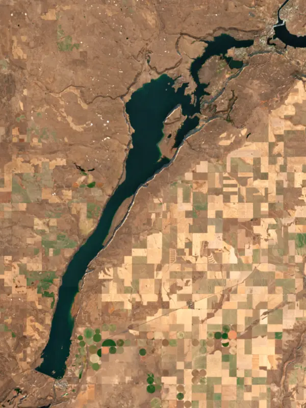
Banks Lake fills the upper Grand Coulee in central Washington, running about 27 miles from Electric City in the north to Coulee City in the south. It is the storage reservoir of the Columbia Basin Project, holding water pumped up from the Columbia River behind Grand Coulee Dam until farms to the south need it. Anglers know it for walleye and smallmouth bass, and campers know it for Steamboat Rock.
The Grand Coulee is an old, cliff-walled channel of the Columbia. During the last ice age, ice dams pushed the river out of its usual course and into this channel, and the huge Missoula Floods tore through the region and carved the scablands of the Columbia Plateau. When the ice was gone, the river went back to its old bed and left the coulee dry. The Bureau of Reclamation turned the empty canyon into a reservoir by closing both ends. Dry Falls Dam went up at the south end between 1946 and 1949, and North Dam at the north end between 1946 and 1951. On June 14, 1951, the first water was pumped out of Franklin D. Roosevelt Lake, lifted roughly 300 feet and sent through the Feeder Canal into the coulee. Water reached farms in 1952, and towns across the basin celebrated from late May into June that year.
In 1958 the reservoir was named Banks Lake in memory of Frank A. Banks, the Reclamation engineer put in charge of building Grand Coulee Dam when work began in 1933. He stayed with the project until he retired in 1950. The pumping plant that feeds the lake now carries the name of John W. Keys III. At the south end, water leaves through outlet gates at Dry Falls Dam next to Coulee City and enters the Main Canal, which carries it on to the farms of the basin.
Near the north end, Steamboat Rock rises about 800 feet above the water. The basalt butte was an island in the ice-age river channel, and its flat top of more than 600 acres was used by Native peoples and early settlers. Steamboat Rock State Park, established in 1972, wraps around it with campgrounds from primitive sites to full hookups, cabins, boat launches and a trail that climbs through columnar basalt to the summit, with views over the coulee. Nearby Northrup Canyon has a trail to the remains of an old homestead and a campground for riders and their horses. The park stays open all year, and winter visitors come for cross-country skiing and ice fishing.
Smallmouth bass and walleye are the fish most anglers come for, though lake whitefish are the most numerous. Walleye fishing peaks before and after the April spawn and stays good through much of summer. Bass bite best around the spring spawn and again in fall. Kokanee, rainbow trout, yellow perch, black crappie and largemouth bass round out the catch. In early to mid-December whitefish crowd the shoreline to spawn, and in most winters the lake freezes over and draws ice anglers after perch and crappie. Shore fishing is good along the east side, and the state runs access sites at Ankeny, Barker Canyon and Million Dollar Mile.
Every year from late August into early September, Reclamation lowers the lake by several feet to meet fisheries and groundwater replacement goals, then brings it back to its normal operating range. Some ramps can be hard to use during that drawdown, so late-summer boaters should check before they tow.
Written by Lake by Lake from HistoryLink.org, National Park Service, Bureau of Reclamation, Washington State Parks, Washington Department of Fish and Wildlife and Wikipedia. Checked November 2026.
Activities listed by the Bureau of Reclamation: Boating · Camping · Ranger programs · Fishing · Hiking · Hunting · Off-road vehicles · Picnicking · Water sports
North Dam is an earthfill dam 145 feet high and 1,450 feet long on the Upper Grand Coulee River, completed in 1951. It belongs to the Bureau of Reclamation and is run for flood control, irrigation, navigation and hydropower. At its normal level the reservoir holds 1.28 million acre-ft, drained from 263 square miles of land.
From the National Inventory of Dams (U.S. Army Corps of Engineers), NID ID WA00266. Lake or reservoir: what’s the difference?
Where the level comes from: Banks Lake and Dry Falls Dam (BNK) (Bureau of Reclamation (RISE)).
| Lake | Miles | Level (ft) | vs full | 7 days |
|---|---|---|---|---|
| Lake Lenore Live reading | 12 | 1076.68 | — | +0.02 |
| Billy Clapp Lake Well below full | 12 | 1316.73 | −18.27 | −0.39 |
| Soap Lake Live reading | 17 | 1068.45 | — | +0.04 |
| Lake Roosevelt Below full | 28 | 1281.60 | −8.40 | −4.51 |
| Rufus Woods Lake Slightly below full | 30 | 953.90 | −2.10 | +0.80 |
| Lake Pateros At or near full pool | 35 | 779.12 | −1.88 | — |
Compare Banks Lake with Lake Lenore, Billy Clapp Lake, Soap Lake or Lake Roosevelt: size, level, ramps and fish side by side.
Banks Lake is about 87 mi from Spokane, WA and 96 mi from Spokane Valley, WA. See all the lakes near each city.
Banks Lake is at 1,568.28 feet above sea level — 1.72 ft below top of active conservation pool, as of Nov 16, 2026. The level has held steady over the past week.
Banks Lake's top of active conservation pool is 1,570.00 ft, according to U.S. Bureau of Reclamation. Today the lake is 1.72 ft below that mark.
Today's level is 0.47 ft above the median for this date (1,567.81 ft), from the gauge’s long-term daily record.
1,537.14 ft, on November 15, 2011, in the Bureau of Reclamation (RISE) record, which starts in 1955. Today the lake is 31.1 ft above that.
1,570.40 ft, on January 28, 1959, in the Bureau of Reclamation (RISE) record since 1955. That is 0.4 ft above top of active conservation pool.
Banks Lake has 12 boat ramps on our map, including Ankeny Road North, Ankeny Road South, Barker Canyon. Low water can close ramps, so check today's level above and the operator before you go.
Yes. There are 7 campgrounds and RV parks within about a mile of the shore, such as Coulee City Community Park, Coulee Playland, Coulee City Campground.
Game fish recorded in Banks Lake include largemouth bass, black crappie, smallmouth bass, walleye, kokanee salmon, yellow perch. In all, 14 fish species have open records inside the lake on GBIF.
Anglers 16 and older need a Washington fishing license, sold online by the Washington Department of Fish and Wildlife. Free fishing days: First weekend after the first Monday in June. Size and bag limits can be set lake by lake: check the current regulations.
Banks Lake is about 46 ft deep at its deepest point, usually near the dam. Depth changes with the lake level.
Bureau of Reclamation lists boating, camping, ranger programs, fishing, hiking, hunting, off-road vehicles and picnicking at Banks Lake.
EPA's CyAN satellite rated cyanobacteria in Banks Lake not detected on November 9. The satellite sees open water only; blooms can be patchy, so avoid water that looks like spilled paint or pea soup and keep dogs out of scum. Swimming advisories come from Washington health and environment agencies.
Yes. Washington Department of Fish and Wildlife stocked rainbow trout and steelhead in Banks Lake; the latest stocking on record was on October 6, 2026.
Yes. A trail runs along or near the shore, including Steamboat Rock Butte (0.9 mi), according to OpenStreetMap.
Banks Lake is held back by North Dam, completed in 1951 and 145 ft high, according to the National Inventory of Dams.
From the Bureau of Reclamation (RISE) (Banks Lake and Dry Falls Dam (BNK)). Lake by Lake checks it every hour; the agency's own figure is always the reference, and provisional readings can be revised.
Every day. The Bureau of Reclamation publishes Banks Lake’s level as one reading a day, usually two to seven days after the day it was measured, so the latest reading here is often a few days old; its date is shown next to it.
Cookies for analytics With your OK we use Google Analytics and Microsoft Clarity to count visits and see how the site is used, so we can make it better. No advertising cookies. Privacy policy




