Sun
- Sunrise
- 7:04 AM
- Sunset
- 4:19 PM
- First light
- 6:30 AM
- Last light
- 4:53 PM
Reservoir · Grant County, Washington
A reservoir on Crab Creek in Grant County, Washington, held back by Moses Lake South Dam since 1961.

Moses Lake is at 1,042.33 feet above sea level, as of Nov 17, 2026, 6:00 PM PST. It has dropped 1.03 ft in the past 7 days.
7th highest of 13 Washington lakes today against normal for the date · See the ranking
Record low 1,040.69 ft (2022), record high 1,047.25 ft (1988) · Level history since 1974
A notification from this browser, once, when the level crosses the line (checked every hour). No account and no email. On an iPhone, add Lake by Lake to your home screen first (Share → Add to Home Screen) and open it from there. Or follow the lake in a feed reader: RSS feed.
Moses Lake is down 4.43 ft over the last 30 days, at 1,042.33 ft today.
Daily values from the U.S. Geological Survey.
Over the past 12 months, Moses Lake ranged from 1,041.46 ft (Dec 10, 2025) to 1,046.86 ft (May 14, 2026), a swing of 5.4 ft. Today's level is near the bottom of that range. It is 0.07 ft lower than on this date last year.
Daily values from the U.S. Geological Survey. Why lake levels rise and fall
In the U.S. Geological Survey record, which starts in 1974, the lowest level was 1,040.69 ft on January 14, 2022 and the highest 1,047.25 ft on April 9, 1988. Today’s 1,042.33 ft is 1.6 ft above the record low and 4.9 ft below the record high.
Moses Lake level history: every year since 1974, the lowest and highest years →
Solunar periods for Moses Lake, local time. How they work
Not detected · as of Nov 9, 2026
The satellite found no cyanobacteria at the surface.
Week of Aug 9Week of Nov 1
Each bar is one week, colored by the worst reading of that week.
From the U.S. EPA's Cyanobacteria Assessment Network (CyAN), which reads the color of lakes from the Sentinel-3 satellites; it sees open water only, not coves or the shoreline. Blooms can be patchy: what you see on the water matters more. Swimming closures and health advisories come from Washington health and environment agencies. How to read it
Surface water temperature
50°F on Oct 29, 2026
82°F · Jul 2550°F · Oct 29
32°F cooler than on Jul 25, 2026.
Estimated from Landsat 8/9 (USGS) passes on clear days: the top layer of the water, a few degrees either way. Coves and the shallows can be warmer.
Moses Lake water temperature: trend, swimming and the fish →
On or near the shore of Moses Lake: 6 boat ramps, 2 rental outfits, 6 campgrounds, 1 beach and 1 fishing pier. The lake has about 67 miles of shoreline, counting its islands.
Tap an icon for details; use two fingers (or Ctrl + scroll) to move the map. Tap a dot for details. Map and lake outline © OpenStreetMap contributors. Places from OpenStreetMap, Overture Maps and Recreation.gov. Not for navigation.
What you’ll find on the shore
← AllBoating 6
← AllRentals & tours 2
← AllFishing spots 2
← AllBeaches 1
← AllCamping 6
← AllLodging 20
← AllParks 15
← AllDining 24+
These invasive plants and animals have been recorded in Moses Lake: clean, drain and dry everything before you go to another lake.
Washington: Stop at every open watercraft check station (required for motorized and nonmotorized boats), and clean and drain your boat after each use, removing plants, animals and water. Required: Aquatic Invasive Species Prevention Permit (out-of-state boats) ($24 a year for out-of-state boats). State rules
Records: USGS Nonindigenous Aquatic Species database. A species not listed may still be present.
In the last 12 months, Washington Department of Fish and Wildlife stocked 24,828 fish in Moses Lake: rainbow trout (24,828).
All 9 stockings · Source: Washington Department of Fish and Wildlife stocking records.
Species with open-licensed records inside Moses Lake's outline, from GBIF.org (surveys, museum collections and angler reports). A record shows a fish was found here, not how many there are now. marks fish the state stocks here.
Shallow, protected flats in spring; docks, grass and deep edges in summer heat.
Brush piles, docks and bridge pilings; shallow for a few weeks in spring.
Rocky points, gravel and current breaks; deeper rock piles in summer.
Rocky shorelines at night after ice-out; deep weed edges and humps in summer.
Cool water: near the surface in spring and fall, deep in summer.
Water temperature sets off each spawn; the bars show the usual months at this latitude and elevation, and move with a warm or cold spring.
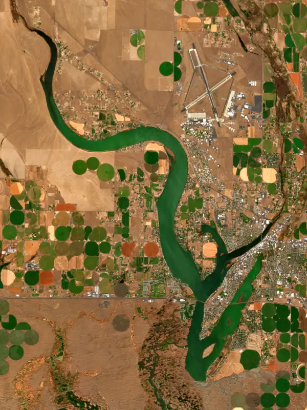
Moses Lake is a long, branching natural lake on Crab Creek in Grant County, in the dry center of Washington, with the city of the same name spread along its shores. It is the third largest natural lake in the state, a working part of the Columbia Basin Project, and a year-round fishery for walleye, bass, perch and crappie.
The lake owes its shape to the land around it. Wind-blown sand dunes dammed part of the Crab Creek drainage to form it, and the Rocky Ford arm was cut by the great ice age floods as they poured out of the lower end of the Grand Coulee. Long, narrow arms called horns reach out from the main body, among them Parker, Pelican and Lewis horns, and the Rocky Ford arm is fed by spring water from Rocky Ford Creek, which rises near Ephrata.
The lake is named for Chief Moses, who lived from 1829 to 1899 and whose people dug camas roots and gathered waterfowl eggs here. Ranchers and settlers pushed them out in the 1880s and 1890s. A village called Neppel grew up around 1910, and about 1911 farmers built a dam to keep the lake from breaking through the dunes at its outlet and pumped its water to new apple orchards. The orchards failed in the early 1930s. In 1904 floodwater had breached the outlet and let in carp, which have dominated the lake ever since, and in the 1920s locals netted them and shipped them to markets in New York. The town took the lake's name in 1938.
The Army opened an air base beside the lake in 1942. It became Larson Air Force Base, guarded the skies over Hanford and Grand Coulee Dam, and closed in 1966, and from 1968 Japan Airlines trained its pilots at the old base. The bigger change was water. From the early 1950s the Bureau of Reclamation brought Columbia River water into upper Crab Creek for the Columbia Basin Project, farms spread around the lake, and far more water began running into it.
Moses Lake now sits in the middle of the project's plumbing. Since 1980, Reclamation has sent water down the East Low Canal and the Rocky Coulee Wasteway into Crab Creek near the north end of the lake, early and late in the irrigation season, and that water flows through the lake and out its outlet structure into Potholes Reservoir to the south.
All that farm runoff fed the lake phosphorus, and blue-green algae followed. The blooms form floating mats that wash up and rot on beaches, they have been linked to fish kills, and they have closed swimming areas. Over the decades, managers flushed the lake with Columbia River water, diverted the city's sewage, worked with farmers and built a pond to catch nutrients upstream. The water improved, but the blooms persist. Some produce toxins, and in 2022 the county health district warned people to keep out of the water at Blue Heron Park after one sample there tested far above the safe limit for microcystin. Blooms can last into October, so check advisories before swimming or letting a dog drink from the lake in late summer.
State surveys find walleye and smallmouth bass in high numbers, and walleye here can top 10 pounds. In April, walleye fishing from shore at the Alder Street Fill can be excellent. Largemouth bass fishing can be excellent in some parts of the lake, and yellow perch school up and bite well from fall through winter. When the lake freezes, ice anglers go after perch and crappie, most often near Blue Heron Park. Bluegill, channel catfish and rainbow trout round out the catch, and the lake is open all year.
Written by Lake by Lake from HistoryLink.org, U.S. Bureau of Reclamation, Washington State Department of Ecology, Washington Department of Fish and Wildlife, The Spokesman-Review and Wikipedia. Checked November 2026.
Moses Lake South Dam is an earthfill dam 12 feet high and 350 feet long on Crab Creek, completed in 1961. It belongs to the Bureau of Reclamation and is run for irrigation and recreation. At its normal level the reservoir holds 50,000 acre-ft, drained from 2,689 square miles of land.
From the National Inventory of Dams (U.S. Army Corps of Engineers), NID ID WA00128. Lake or reservoir: what’s the difference?
Where the level comes from: MOSES LAKE AT MOSES LAKE, WA (U.S. Geological Survey, used on this page) and Moses Lake at Moses Lake (NOAA National Water Prediction Service).
| Lake | Miles | Level (ft) | vs full | 7 days |
|---|---|---|---|---|
| Potholes Reservoir Below full | 9 | 1038.80 | −7.70 | +0.97 |
| Soap Lake Live reading | 22 | 1068.45 | — | +0.05 |
| Billy Clapp Lake Well below full | 24 | 1316.73 | −18.27 | −0.39 |
| Lake Lenore Live reading | 30 | 1076.68 | — | +0.03 |
| Scooteney Reservoir Live reading | 33 | 918.84 | — | +0.91 |
| Wanapum Lake Slightly below full | 35 | 569.41 | −2.09 | +1.72 |
Compare Moses Lake with Potholes Reservoir, Soap Lake, Billy Clapp Lake or Lake Lenore: size, level, ramps and fish side by side.
Moses Lake is about 96 mi from Spokane, WA. See all the lakes near each city.
Moses Lake is at 1,042.33 feet above sea level, as of Nov 17, 2026, 6:00 PM PST. It has dropped 1.03 ft in the past 7 days.
Today's level is 1.44 ft below the median for this date (1,043.77 ft), from the gauge’s long-term daily record.
1,040.69 ft, on January 14, 2022, in the U.S. Geological Survey record, which starts in 1974. Today the lake is 1.6 ft above that.
1,047.25 ft, on April 9, 1988, in the U.S. Geological Survey record since 1974.
Moses Lake has 6 boat ramps on our map, including Blue Heron Park Boat Launch, Boat ramp near Cascade Campground, Boat ramp near Pier 4 RV Resort. Low water can close ramps, so check today's level above and the operator before you go.
Yes. There are 6 campgrounds and RV parks within about a mile of the shore, such as Cascade Campground, Lakefront RV Park, Pier 4 RV Resort.
Game fish recorded in Moses Lake include largemouth bass, black crappie, smallmouth bass, walleye, yellow perch, brown bullhead. In all, 9 fish species have open records inside the lake on GBIF.
Anglers 16 and older need a Washington fishing license, sold online by the Washington Department of Fish and Wildlife. Free fishing days: First weekend after the first Monday in June. Size and bag limits can be set lake by lake: check the current regulations.
Moses Lake is about 18 ft deep at its deepest point, usually near the dam, and about 9 ft deep on average. Depth changes with the lake level.
boating (6 boat ramps), kayaks, boats & jet skis (2 rental outfits on or near the water), fishing (8 game fish and 1 fishing pier or spot; stocked by the state), swimming (1 beach or swimming area), camping (6 campgrounds) and cabins & lodging (20 places to stay close to the water), according to our map of the shore.
EPA's CyAN satellite rated cyanobacteria in Moses Lake not detected on November 9. The satellite sees open water only; blooms can be patchy, so avoid water that looks like spilled paint or pea soup and keep dogs out of scum. Swimming advisories come from Washington health and environment agencies.
Yes. Washington Department of Fish and Wildlife stocked rainbow trout in Moses Lake; the latest stocking on record was on June 23, 2026.
Moses Lake is held back by Moses Lake South Dam, completed in 1961 and 12 ft high, according to the National Inventory of Dams.
From the U.S. Geological Survey (MOSES LAKE AT MOSES LAKE, WA). Lake by Lake checks it every hour; the agency's own figure is always the reference, and provisional readings can be revised.
Lake levels are refreshed every hour. Texas and California reservoirs report once a day; most USGS and NOAA gauges report every 15 to 60 minutes.




