Sun
- Sunrise
- 6:56 AM
- Sunset
- 5:04 PM
- First light
- 6:29 AM
- Last light
- 5:32 PM
Reservoir · Carroll County, Arkansas
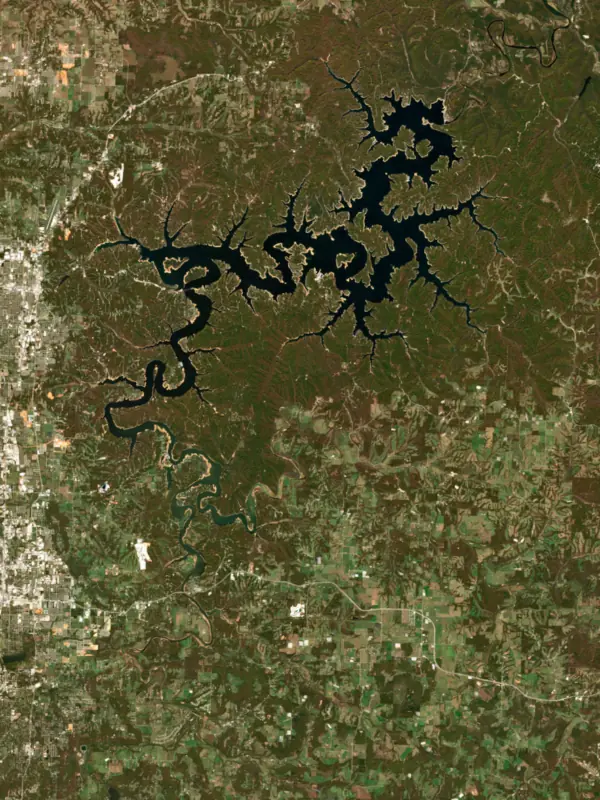
A reservoir on the White in Carroll County, Arkansas, held back by Beaver Dam since 1963.

Beaver Lake is at 1,110.84 feet above sea level — 9.16 ft below normal pool, as of Nov 18, 2026, 11:00 PM CST. It has dropped 0.49 ft in the past 7 days.
3rd lowest of 11 Arkansas lakes today against full pool · See the ranking
Record low 1,110.83 ft (2026), record high 1,129.95 ft (2025) · Level history since 2023
A notification from this browser, once, when the level crosses the line (checked every hour). No account and no email. On an iPhone, add Lake by Lake to your home screen first (Share → Add to Home Screen) and open it from there. Or follow the lake in a feed reader: RSS feed.
Beaver Lake is down 0.49 ft over the last 7 days, at 1,110.84 ft today.
Daily values from the NOAA National Water Prediction Service.
Beaver Lake is down 1.65 ft over the last 30 days, at 1,110.84 ft today.
Daily values from the NOAA National Water Prediction Service.
Over the past 12 months, Beaver Lake ranged from 1,110.83 ft (Nov 18, 2026) to 1,126.65 ft (Jul 1, 2026), a swing of 15.8 ft. Today's level is near the bottom of that range. It is 8.74 ft lower than on this date last year.
Daily values from the NOAA National Water Prediction Service. Why lake levels rise and fall
In the U.S. Army Corps of Engineers record, which starts in 2023, the lowest level was 1,110.83 ft on November 18, 2026 and the highest 1,129.95 ft on May 27, 2025. Today’s 1,110.84 ft is 0.0 ft above the record low and 19.1 ft below the record high.
Beaver Lake level history: every year since 2023, the lowest and highest years →
Solunar periods for Beaver Lake, local time. How they work
Very high · as of Nov 9, 2026
The satellite sees a strong bloom on part of the lake. Stay out of discolored water, keep pets away and check for state advisories. About 1,110,000 cells/mL at the worst spot, covering 6% of the lake.
Week of Aug 16Week of Nov 1
Each bar is one week, colored by the worst reading of that week.
From the U.S. EPA's Cyanobacteria Assessment Network (CyAN), which reads the color of lakes from the Sentinel-3 satellites; it sees open water only, not coves or the shoreline. Blooms can be patchy: what you see on the water matters more. Swimming closures and health advisories come from Arkansas health and environment agencies. How to read it
Surface water temperature
66°F on Nov 8, 2026
87°F · Jul 2766°F · Nov 8
22°F cooler than on Jul 27, 2026.
Estimated from Landsat 8/9 (USGS) passes on clear days: the top layer of the water, a few degrees either way. Coves and the shallows can be warmer.
Beaver Lake water temperature: trend, swimming and the fish →
On or near the shore of Beaver Lake: 21 boat ramps, 9 marinas, 2 rental outfits, 34 campgrounds, 3 beaches, 8 trails and 2 fishing guides. The lake has about 471 miles of shoreline, counting its islands.
Tap an icon for details; use two fingers (or Ctrl + scroll) to move the map. Tap a dot for details. Map and lake outline © OpenStreetMap contributors. Places from OpenStreetMap, Overture Maps and Recreation.gov. Not for navigation.
What you’ll find on the shore
← AllBoating 30
← AllRentals & tours 3
← AllFishing spots 10
← AllBeaches 3
← AllCamping 34
← AllLodging 24+
← AllTrails 8
← AllParks 9
← AllDining 2
No aquatic invasive species are on record for Beaver Lake in the USGS database. Keep it that way: clean, drain and dry your boat between lakes.
Arkansas: Pull every drain plug (bilge, livewell, baitwell and ballast) before and while trailering a boat to or from any access, a rule in force since 2021. Clean, drain and dry is urged, and possessing or moving listed invasive species such as zebra mussels is illegal. State rules
Records: USGS Nonindigenous Aquatic Species database. A species not listed may still be present.
Species with open-licensed records inside Beaver Lake's outline, from GBIF.org (surveys, museum collections and angler reports). A record shows a fish was found here, not how many there are now.
Shallow, protected flats in spring; docks, grass and deep edges in summer heat.
Channel edges and river arms; best after dark in summer, and after a rain.
Rocky points, gravel and current breaks; deeper rock piles in summer.
Rocky shorelines at night after ice-out; deep weed edges and humps in summer.
Run up the river arms in spring; follow shad to cool, deep water near the dam in summer.
Water temperature sets off each spawn; the bars show the usual months at this latitude and elevation, and move with a warm or cold spring. The water is about 66°F now.
Beaver Lake is the Army Corps of Engineers reservoir on the upper White River in the Ozarks of northwest Arkansas, reaching about 73 miles from near Eureka Springs toward Fayetteville. It holds back floods, generates power and supplies drinking water to the cities of Benton and Washington counties, and it is known for limestone bluffs, striped bass and the many people who make their homes along it.
The upper White River was looked at for a dam as early as 1911, and the Corps studied it again in 1929 and 1930. Congress authorized the project in 1954. The Water Supply Act of 1958 then let a local sponsor pay for extra storage, and the Beaver Water District was formed so Rogers, Bentonville, Fayetteville and Springdale could buy water from the lake. When the first construction money came through in a public works bill in 1959, President Eisenhower vetoed it, objecting to uncertainty over how the power would be sold, and Congress overrode him. The project took its name from Beaver, a Carroll County town named for 1850s settler Wilson Ashbury Beaver, but the site near the town proved unsuitable and the dam went up a few miles upstream near Busch. Ground was broken in November 1960, the turbines began turning in May 1965, the project was finished in June 1966, and the lake first reached normal pool in 1968.
The most famous place under the lake is Monte Ne. In 1900 William H. Harvey, known as Coin Harvey, bought 320 acres at a place called Silver Springs, renamed it and built a resort with large log hotels, a golf course, an enclosed swimming pool and a five-mile railroad. When interest faded around 1920, he announced a great pyramid to carry a message to future generations, but building its amphitheater used up the money and the pyramid was never completed. In 1931 the Liberty Party held its national convention at the amphitheater and nominated Harvey for president. He died at Monte Ne in 1936. Beaver Lake later covered most of the resort. Parts of two hotels and Harvey's tomb stayed above the water, the amphitheater shows only when the lake is extremely low, and in 2023 the Corps began removing the Oklahoma Row hotel ruins as a safety hazard.
The lake winds through Benton, Carroll and Washington counties past limestone bluffs and natural caves, fed by the White River and War Eagle Creek. The Corps runs many parks around it, among them Dam Site, Hickory Creek, Horseshoe Bend, Lost Bridge, Prairie Creek, Rocky Branch, Starkey and War Eagle, and several have marinas. Hobbs State Park-Conservation Area, one of the largest conservation areas in Arkansas at more than 12,000 acres, borders the lake. Because it sits so close to the cities of northwest Arkansas, Beaver is mostly a residential lake, and many people living on it commute to work.
Beaver is among the few Arkansas lakes stocked with striped bass. Each April the stripers run up the tributary arms to spawn, but their eggs cannot survive in Arkansas lakes, so the fishery depends on hatchery fish. The 64-pound 8-ounce striper that set the state record came from the Beaver tailwater on April 28, 2000, and a 127-pound paddlefish caught in the lake in June 2024 set the state rod-and-reel record. Promoter Ray Scott held the first modern bass tournament here on June 5 to 7, 1967. Walleye run up the White River and War Eagle Creek in March, usually peaking around the third week, and Twin Bridges Access on Highway 45 lets shore anglers reach them. Below the dam the river runs as trout water for about 7 miles before widening into Table Rock Lake, and anglers there need a trout permit even when they are after walleye.
Written by Lake by Lake from CALS Encyclopedia of Arkansas (Beaver Dam and Lake, Monte Ne (Benton County)), U.S. Army Corps of Engineers and Arkansas Game and Fish Commission (Striped Bass, Winter walk-in walleye options for Arkansas anglers, Arkansas State Record Fish). Checked November 2026.
Activities listed by the U.S. Army Corps of Engineers: Boating · Camping · Fishing · Hiking · Picnicking · Water sports · Wildlife viewing
Beaver Dam is a concrete dam 228 feet high and 720 feet long on the White, completed in 1963. It belongs to the U.S. Army Corps of Engineers (Little Rock District) and is run for flood control, recreation, hydropower and water supply. At its normal level the reservoir holds 1.65 million acre-ft, drained from 1,186 square miles of land.
From the National Inventory of Dams (U.S. Army Corps of Engineers), NID ID AR00174. Lake or reservoir: what’s the difference?
Where the level comes from: Northwest Arkansas Lakes at Beaver Lake (NOAA National Water Prediction Service).
| Lake | Miles | Level (ft) | vs full | 7 days |
|---|---|---|---|---|
| Table Rock Lake Slightly below full | 32 | 909.55 | −5.45 | −0.47 |
| Lake Taneycomo At or near full pool | 36 | 700.80 | −0.55 | −1.31 |
| Lake Eucha Below full | 61 | 769.72 | −8.28 | −0.17 |
| Grand Lake o' the Cherokees At or near full pool | 66 | 741.96 | −0.04 | −0.01 |
| Spavinaw Lake Live reading | 67 | 679.83 | — | −0.13 |
| Bull Shoals Lake Below full | 71 | 652.21 | −6.79 | −0.26 |
Compare Beaver Lake with Table Rock Lake, Lake Taneycomo, Lake Eucha or Grand Lake o' the Cherokees: size, level, ramps and fish side by side.
Beaver Lake is about 30 mi from Fayetteville, AR. See all the lakes near each city.
Beaver Lake is at 1,110.84 feet above sea level — 9.16 ft below normal pool, as of Nov 18, 2026, 11:00 PM CST. It has dropped 0.49 ft in the past 7 days.
Beaver Lake's normal pool is 1,120.00 ft, according to U.S. Army Corps of Engineers. Today the lake is 9.16 ft below that mark.
1,110.83 ft, on November 18, 2026, in the U.S. Army Corps of Engineers record, which starts in 2023. Today the lake is 0.0 ft above that.
1,129.95 ft, on May 27, 2025, in the U.S. Army Corps of Engineers record since 2023. That is 10.0 ft above normal pool.
Beaver Lake has 21 boat ramps on our map, including Blue Springs Boat Ramp, Boat ramp at Hickory Creek Marina, Boat ramp near Rocky Branch Park, and 9 marinas. Low water can close ramps, so check today's level above and the operator before you go.
Yes. There are 34 campgrounds and RV parks within about a mile of the shore, such as Horseshoe Bend (Beaver Lake) Campground, Lost Bridge North Campground, Rocky Branch Public Use Area.
Game fish recorded in Beaver Lake include striped bass, spotted bass, bluegill, walleye, channel catfish, smallmouth bass. In all, 40 fish species have open records inside the lake on GBIF.
The surface of Beaver Lake was about 66°F on November 8, estimated from a satellite pass on a clear day. It is the top layer of the water, a few degrees either way; coves and shallows run warmer in the sun.
Anglers 16 and older need an Arkansas fishing license, sold online by the Arkansas Game and Fish Commission. Free fishing days: Free Fishing Weekend in June (2026: June 12-14); no trout permit needed either. Size and bag limits can be set lake by lake: check the current regulations.
NOAA's flood categories for the Beaver Lake gauge: minor flooding at 1130.0 ft, moderate flooding at 1131.0 ft and major flooding at 1132.0 ft. Today the lake is 19.16 ft below the first flooding level.
Beaver Lake averages about 59 ft deep. Depth changes with the lake level.
In summer a white Secchi disk lowered into Beaver Lake stays visible to about 8.9 ft (the median of 40 readings, 2016–2022, by North American Lake Management Society and Arkansas Department of Environmental Quality): clear water. With the algae measured too (chlorophyll about 8 µg/L), that makes it mesotrophic: moderately rich in nutrients. Clarity drops after storms and during algae blooms.
Yes: bathymetric map (2 sheets) from the U.S. Geological Survey (2018). It is linked in the lake facts on this page. Depths on a map are measured at a reference level: subtract how far the lake is below it today.
U.S. Army Corps of Engineers lists boating, camping, fishing, hiking, picnicking, water sports and wildlife viewing at Beaver Lake. 11 campgrounds can be booked on Recreation.gov.
EPA's CyAN satellite rated cyanobacteria in Beaver Lake very high on November 9. The satellite sees open water only; blooms can be patchy, so avoid water that looks like spilled paint or pea soup and keep dogs out of scum. Swimming advisories come from Arkansas health and environment agencies.
Yes. 8 trails run along or near the shore, including Karst Trail (7.8 mi), Lost Bridge Trail (4.5 mi) and Pigeon Roost Trail - Dry Creek Loop (2.6 mi), according to OpenStreetMap.
Beaver Lake is held back by Beaver Dam, completed in 1963 and 228 ft high, according to the National Inventory of Dams.
From the NOAA National Water Prediction Service (Northwest Arkansas Lakes at Beaver Lake). Lake by Lake checks it every hour; the agency's own figure is always the reference, and provisional readings can be revised.
Lake levels are refreshed every hour. Texas and California reservoirs report once a day; most USGS and NOAA gauges report every 15 to 60 minutes.
Cookies for analytics With your OK we use Google Analytics and Microsoft Clarity to count visits and see how the site is used, so we can make it better. No advertising cookies. Privacy policy




