Sun
- Sunrise
- 7:25 AM
- Sunset
- 5:07 PM
- First light
- 6:54 AM
- Last light
- 5:37 PM
Lake · Macomb County, Michigan
A lake fed by the St. Clair River in Macomb County, Michigan, held back by St Clair Flats Dikes Dam since 1964. Also called Lake Saint Clair.

Lake St. Clair is at 574.37 feet above sea level, as of Nov 17, 2026, 9:24 PM EST. The level has held steady over the past week.
A notification from this browser, once, when the level crosses the line (checked every hour). No account and no email. On an iPhone, add Lake by Lake to your home screen first (Share → Add to Home Screen) and open it from there. Or follow the lake in a feed reader: RSS feed.
Lake St. Clair is down 0.40 ft over the last 30 days, at 574.37 ft today.
Daily values from the NOAA National Water Prediction Service. Why lake levels rise and fall
Solunar periods for Lake St. Clair, local time. How they work
High · as of Nov 9, 2026
The satellite sees a likely bloom on part of the lake. Avoid discolored water and scum, and keep dogs out of it. About 398,000 cells/mL at the worst spot, covering less than 1% of the lake.
Week of Aug 16Week of Nov 1
Each bar is one week, colored by the worst reading of that week.
From the U.S. EPA's Cyanobacteria Assessment Network (CyAN), which reads the color of lakes from the Sentinel-3 satellites; it sees open water only, not coves or the shoreline. Blooms can be patchy: what you see on the water matters more. Swimming closures and health advisories come from Michigan health and environment agencies. How to read it
Surface water temperature
51°F on Nov 14, 2026
76°F · Jul 2151°F · Nov 14
25°F cooler than on Jul 21, 2026.
Estimated from NOAA’s Great Lakes analysis passes on clear days: the top layer of the water, a few degrees either way. Coves and the shallows can be warmer.
Lake St. Clair water temperature: trend, swimming and the fish →
On or near the shore of Lake St. Clair: 22 boat ramps, 80 marinas, 14 rental outfits, 4 campgrounds, 16 beaches, 10 trails and 4 fishing guides. The lake has about 586 miles of shoreline, counting its islands.
Tap an icon for details; use two fingers (or Ctrl + scroll) to move the map. Tap a dot for details. Map and lake outline © OpenStreetMap contributors. Places from OpenStreetMap, Overture Maps and Recreation.gov. Not for navigation.
What you’ll find on the shore
← AllBoating 102+
← AllRentals & tours 15
← AllFishing spots 11
← AllBeaches 16
← AllCamping 4
← AllLodging 24+
← AllTrails 10
← AllParks 20+
← AllDining 24+
Zebra mussels and Quagga mussels have been found in Lake St. Clair. They clog intakes and engines and spread on boats and trailers: clean, drain and dry everything before you go to another lake.
Michigan: Remove all aquatic plants from the boat, gear and trailer before launching. Before driving away, pull all drain plugs (bilge, ballast, livewell), drain all water and make sure boat and trailer are free of plants and animals; dispose of unused bait on land or in the trash. State rules
Records: USGS Nonindigenous Aquatic Species database. A species not listed may still be present.
Species with open-licensed records inside Lake St. Clair's outline, from GBIF.org (surveys, museum collections and angler reports). A record shows a fish was found here, not how many there are now.
Shallow, protected flats in spring; docks, grass and deep edges in summer heat.
Brush piles, docks and bridge pilings; shallow for a few weeks in spring.
Channel edges and river arms; best after dark in summer, and after a rain.
Rocky points, gravel and current breaks; deeper rock piles in summer.
Rocky shorelines at night after ice-out; deep weed edges and humps in summer.
Water temperature sets off each spawn; the bars show the usual months at this latitude and elevation, and move with a warm or cold spring. The water is about 51°F now.
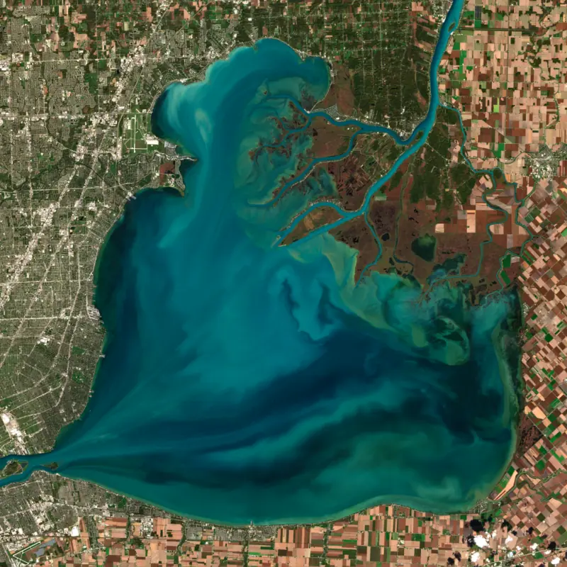
Lake St. Clair is the broad, shallow lake between Lake Huron and Lake Erie, shared by Michigan and Ontario just northeast of Detroit and Windsor. Water from the upper Great Lakes moves through it in about a week, entering by the St. Clair River and leaving by the Detroit River, while lake freighters cross it in a dredged channel. Anglers know it best for smallmouth bass and muskellunge.
The lake lies in the traditional territory of the Haudenosaunee, Ojibwe, Miami and Potawatomi peoples, and Louis Hennepin recorded an Iroquoian name for it, Otseketa. The French mapmaker Nicolas Sanson labeled it Lac des eaux de mer on a map in 1656. In 1670 two missionaries, François Dollier de Casson and René de Bréhant de Galinée, left the first detailed account of crossing it. The name that stuck came on August 12, 1679, when the expedition of René-Robert Cavelier, Sieur de La Salle, reached the lake on the feast day of Saint Clare of Assisi and called it Lac Sainte-Claire. The spelling St. Clair shows up on a map from 1755. The name is often credited to General Arthur St. Clair, but it was in use long before he became well known.
At the northeast corner the St. Clair River spreads into a maze of channels, marsh and islands known as the St. Clair Flats, counted as the largest delta in the Great Lakes. The Canadian side of the delta is home to the Bkejwanong (Walpole Island) First Nation. On the Michigan side, Anchor Bay forms the lake's northern end, bordered by Harsens and Dickinson islands, the city of New Baltimore and the townships of Chesterfield, Harrison and Ira. The Clinton River enters from Michigan and the Thames from Ontario. The natural bottom is so shallow that the navigation channel kept open for ships is more than twice as deep as the lake around it. That channel is part of the seaway route from Lake Superior to the Gulf of St. Lawrence.
More than 110 kinds of fish live in the lake. The ones most anglers chase are smallmouth bass, muskellunge, walleye and yellow perch. Smallmouth are the headline. Michigan DNR research drawing on five decades of survey data found the bass are now older and larger than they were in the 1970s and 1980s, and the researchers credit catch-and-release above all. In the early 1970s anglers kept around 30,000 smallmouth a year. In 2023 they released 97 percent of the smallmouth they caught, more than 32,000 fish. The minimum size limit went from 12 to 14 inches in the mid-1990s. Bassmaster Magazine ranked Lake St. Clair 10th on its 2025 list of the 100 best bass lakes in the country, and the Bassmaster Elite Series has held events here several times, including one based at Brandenburg Park in Chesterfield Township in August 2025.
The lake also has a place in the history of Great Lakes pollution and invasive species. Commercial fishing on the Canadian side was shut down in 1970 after high mercury levels turned up in fish, traced mostly to petrochemical plants along the St. Clair River, and both governments publish advice on eating fish from the lake. In June 1988 zebra mussels were found here for the first time in North America, most likely carried from Europe in a ship's ballast water.
On the Michigan shore, Huron-Clinton Metroparks runs Lake St. Clair Metropark in Harrison Township, with a sandy beach, a boardwalk out to Huron Point, 1.5 miles of shoreline for fishing, a nature center with exhibits on the marshes and the French voyageurs, and a bank of boat ramps on Black Creek. In winter the park is used for ice fishing, skating and cross-country skiing.
Written by Lake by Lake from The Canadian Encyclopedia, Wikipedia (Lake St. Clair, Anchor Bay (Michigan)), Great Lakes Now, Huron-Clinton Metroparks and Michigan State University, Department of Geography. Checked November 2026.
St Clair Flats Dikes Dam is an earthfill dam 8 feet high and 66,000 feet long, completed in 1964. It belongs to MDNR Wildlife and is run for recreation. At its normal level the lake holds 2,700 acre-ft.
From the National Inventory of Dams (U.S. Army Corps of Engineers), NID ID MI01823. Lake or reservoir: what’s the difference?
Where the level comes from: Lake St Clair at St Clair Shores Tidal Gauge (NOAA National Water Prediction Service).
| Lake | Miles | Level (ft) | vs full | 7 days |
|---|---|---|---|---|
| Lake Erie Live reading | 40 | 571.06 | — | — |
| Lake Huron Live reading | 44 | 578.36 | — | — |
Compare Lake St. Clair with Lake Erie or Lake Huron: size, level, ramps and fish side by side.
Lake St. Clair is about 46 mi from Ann Arbor, MI and 67 mi from Toledo, OH. See all the lakes near each city.
Lake St. Clair is also known as Lake Saint Clair.
Lake St. Clair is at 574.37 feet above sea level, as of Nov 17, 2026, 9:24 PM EST. The level has held steady over the past week.
Lake St. Clair has 22 boat ramps on our map, including Boat ramp at Mitchell's Bay Marine Park, Boat ramp near Lake St Clair Metro Park Nature Center, Boat ramp near Milk River, and 80 marinas. Low water can close ramps, so check today's level above and the operator before you go.
Yes. There are 4 campgrounds and RV parks within about a mile of the shore, such as Taylor's Beach Campground, St Clair Shores Campground, Northpointe Shores RV Resort.
Game fish recorded in Lake St. Clair include yellow perch, walleye, bluegill, smallmouth bass, largemouth bass, muskellunge. In all, 40 fish species have open records inside the lake on GBIF.
The surface of Lake St. Clair was about 51°F on November 14, estimated from a satellite pass on a clear day. It is the top layer of the water, a few degrees either way; coves and shallows run warmer in the sun.
Anglers 17 and older need a Michigan fishing license, sold online by the Michigan Department of Natural Resources. Free fishing days: Presidents' Day weekend (Sat-Sun) and the Saturday and Sunday after the first full week of June. Size and bag limits can be set lake by lake: check the current regulations.
NOAA's flood categories for the Lake St. Clair gauge: action stage at 576.9 ft and minor flooding at 577.4 ft. Today the lake is 3.03 ft below the first flooding level.
Lake St. Clair is about 11 ft deep at its deepest point. Depth changes with the lake level.
Yes: bathymetry poster of Lake Erie and Lake St. Clair from the NOAA National Centers for Environmental Information. It is linked in the lake facts on this page. Depths on a map are measured at a reference level: subtract how far the lake is below it today.
boating (22 boat ramps and 80+ marinas), kayaks, boats & jet skis (14 rental outfits on or near the water), boat tours (1 boat tour or charter), fishing (27 game fish and 4 fishing guides), swimming (16 beaches and swimming areas) and hiking & walking (10 trails along the shore, the longest Freedom Trail (8.0 mi)), according to our map of the shore.
EPA's CyAN satellite rated cyanobacteria in Lake St. Clair high on November 9. The satellite sees open water only; blooms can be patchy, so avoid water that looks like spilled paint or pea soup and keep dogs out of scum. Swimming advisories come from Michigan health and environment agencies.
Yes. 10 trails run along or near the shore, including Point Walkway (1.1 mi), Mitchell's Bay- South Lakeshore Trail (0.9 mi) and Clinton River Spillway Bike Path (2.4 mi), according to OpenStreetMap.
Lake St. Clair is held back by St Clair Flats Dikes, completed in 1964 and 8 ft high, according to the National Inventory of Dams.
From the NOAA National Water Prediction Service (Lake St Clair at St Clair Shores Tidal Gauge). Lake by Lake checks it every hour; the agency's own figure is always the reference, and provisional readings can be revised.
Lake levels are refreshed every hour. Texas and California reservoirs report once a day; most USGS and NOAA gauges report every 15 to 60 minutes.




