Sun
- Sunrise
- 6:54 AM
- Sunset
- 4:27 PM
- First light
- 6:23 AM
- Last light
- 4:58 PM
Reservoir · Saratoga County, New York
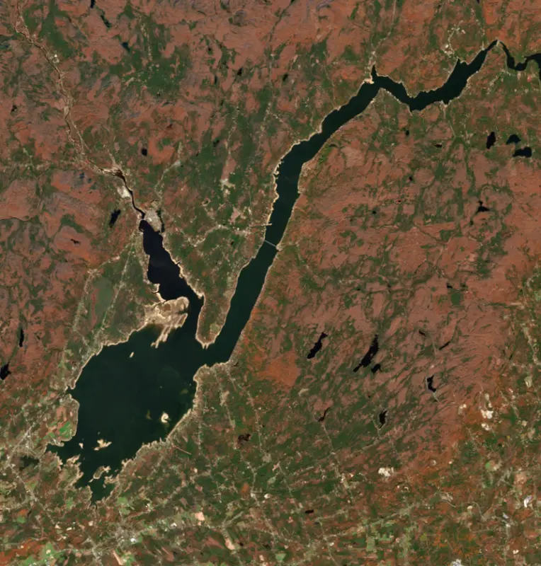
A reservoir on the Sacandaga River in Saratoga County, New York, held back by Conklingville Dam since 1930.

Great Sacandaga Lake is at 755.12 feet above sea level, as of Nov 19, 2026, 5:30 AM EST. It has dropped 0.07 ft in the past 7 days.
Highest of 8 New York lakes today against normal for the date · See the ranking
Record low 729.64 ft (1940), record high 774.40 ft (2011) · Level history since 1930
A notification from this browser, once, when the level crosses the line (checked every hour). No account and no email. On an iPhone, add Lake by Lake to your home screen first (Share → Add to Home Screen) and open it from there. Or follow the lake in a feed reader: RSS feed.
Great Sacandaga Lake is down 0.07 ft over the last 7 days, at 755.12 ft today.
Daily values from the U.S. Geological Survey.
Great Sacandaga Lake is down 1.70 ft over the last 30 days, at 755.12 ft today.
Daily values from the U.S. Geological Survey.
Over the past 12 months, Great Sacandaga Lake ranged from 749.65 ft (Mar 5, 2026) to 769.25 ft (Apr 21, 2026), a swing of 19.6 ft. Today's level is in the lower half of that range. It is 1.61 ft higher than on this date last year.
Daily values from the U.S. Geological Survey. Why lake levels rise and fall
In the U.S. Geological Survey record, which starts in 1930, the lowest level was 729.64 ft on March 30, 1940 and the highest 774.40 ft on May 1, 2011. Today’s 755.12 ft is 25.5 ft above the record low and 19.3 ft below the record high.
Great Sacandaga Lake level history: every year since 1930, the lowest and highest years →
Solunar periods for Great Sacandaga Lake, local time. How they work
Avoid scum and discolored water, and keep dogs out of it.
From the New York State Department of Environmental Conservation, checked Nov 19. Advisories change with the weather: check the agency's page and the signs at the water before you go.
Not detected · as of Nov 9, 2026
The satellite found no cyanobacteria at the surface.
Week of Aug 16Week of Nov 1
Each bar is one week, colored by the worst reading of that week.
From the U.S. EPA's Cyanobacteria Assessment Network (CyAN), which reads the color of lakes from the Sentinel-3 satellites; it sees open water only, not coves or the shoreline. Blooms can be patchy: what you see on the water matters more. Swimming closures and health advisories come from New York health and environment agencies. How to read it
Surface water temperature
47°F on Nov 16, 2026
75°F · Jul 2747°F · Nov 16
28°F cooler than on Jul 27, 2026.
Estimated from MODIS Aqua (NASA) passes on clear days: the top layer of the water, a few degrees either way. Coves and the shallows can be warmer.
Great Sacandaga Lake water temperature: trend, swimming and the fish →
On or near the shore of Great Sacandaga Lake: 7 boat ramps, 18 marinas, 1 rental outfit, 11 campgrounds, 5 beaches and 2 trails. The lake has about 118 miles of shoreline, counting its islands.
Tap an icon for details; use two fingers (or Ctrl + scroll) to move the map. Tap a dot for details. Map and lake outline © OpenStreetMap contributors. Places from OpenStreetMap, Overture Maps and Recreation.gov. Not for navigation.
What you’ll find on the shore
← AllBoating 25
← AllRentals & tours 2
← AllFishing spots 4
← AllBeaches 5
← AllCamping 11
← AllLodging 13
← AllTrails 2
← AllParks 4
← AllDining 13
These invasive plants and animals have been recorded in Great Sacandaga Lake: clean, drain and dry everything before you go to another lake.
New York: Before launching into public water, drain all water and remove any plants or animals from the boat, trailer and gear. In and within 10 miles of the Adirondack Park, motorboats must carry a clean-drain-dry certificate (free from a launch steward or self-issued), and trailered boats must pass an inspection before launching on Lake George. State rules
Records: USGS Nonindigenous Aquatic Species database. A species not listed may still be present.
The last stocking on record was in June 2025 (rainbow trout).
All 5 stockings · Source: New York State Department of Environmental Conservation stocking records.
Species with open-licensed records inside Great Sacandaga Lake's outline, from GBIF.org (surveys, museum collections and angler reports). A record shows a fish was found here, not how many there are now. marks fish the state stocks here.
Brush piles, docks and bridge pilings; shallow for a few weeks in spring.
Cool water: near the surface in spring and fall, deep in summer.
Low light and cold water; the inflows in fall.
Water temperature sets off each spawn; the bars show the usual months at this latitude and elevation, and move with a warm or cold spring. The water is about 47°F now.
Great Sacandaga Lake is the reservoir on the Sacandaga River at the southern edge of the Adirondack Park, spread across Fulton and Saratoga counties with a small reach into Hamilton County. Its broad south end lies northeast of Johnstown and Gloversville. It is the largest reservoir in New York, built to hold back floods on the Hudson, and today its shores are lined with summer camps, beaches and boat launches.
The lake has been here before. After the last ice age a glacial moraine blocked the Sacandaga River and held back Glacial Lake Sacandaga, until the outlet at Conklingville wore down and drained it. The river that remained flooded often, and a dam there had been discussed since the 1860s. In 1913 the worst flood on record struck Albany, Troy, Rensselaer, Watervliet and Green Island. That same year the Burd Amendment allowed up to 3 percent of the state Forest Preserve to be used for reservoirs, a 1915 law made regulating districts possible, and the Hudson River Regulating District was formed in 1922.
Work on the Conklingville Dam began in 1927. A flood in 1929 set the job back, and the dam was finished in 1930 at a cost of $12 million, most of it paid by industries that would use the power. Blocking the old outlet nearly restored the glacial lake. It was called the Sacandaga Reservoir until the 1960s, when it was renamed Great Sacandaga Lake to draw tourists.
Valley residents opposed the dam. About 1,100 people were forced from their homes. All or part of ten communities were flooded: Batchellerville, Fish House, Osborne Bridge, The Vly, Cranberry Creek, Sacandaga Park, Day, Conklingville, Munsonville and Benedict, along with many outlying farms. In all, 3,872 graves were moved from 24 cemeteries, and whatever was left standing as the water rose was burned. Four covered bridges and a steel railroad bridge were taken out, and the Fonda, Johnstown and Gloversville Railroad sued over its flooded tracks and won $1.6 million. The bridge built at Batchellerville in 1930 was replaced in 2012 by a span more than half a mile long.
The Hudson River-Black River Regulating District operates the dam together with the Indian Lake Dam, and between them they control about 40 percent of the water in the upper Hudson basin. The district holds water back when the river runs high and releases it during droughts, so the level is managed to prevent flooding while keeping enough water moving down the Hudson. No public money goes into running the reservoir. About 70 percent of the district's revenue comes from leases with the power companies that run the turbines in the dam.
New York State owns the lake bed and a buffer strip of land between the high water line and the private lots around it. Neighbors need a revocable access permit from the district to use that strip, and docks, stairways and shoreline cutting there are regulated.
On September 15, 1940, Peter Dubuc caught a northern pike of 46 pounds, 2 ounces here, a fish still cited as the North American record. The lake also holds walleye, smallmouth bass, yellow perch, brown trout, landlocked salmon and smelt. The state has public launches on Route 30 in Northville, at Northampton Beach Campground, and off County Route 110 northeast of Broadalbin. Visitors come from across New York, New England and New Jersey, and many own summer camps or second homes on the shore.
Written by Lake by Lake from Hudson River-Black River Regulating District (How did the Regulating District evolve?, Upper Hudson River Watershed, Great Sacandaga Lake Access Permit System) and Wikipedia (Great Sacandaga Lake, Conklingville Dam). Checked November 2026.
Conklingville Dam is an earthfill dam 100 feet high and 1,100 feet long on the Sacandaga River, completed in 1930. It belongs to Hudson River-Black River Regulating District and is run for hydropower, navigation, recreation, water supply and flood control. At its normal level the reservoir holds 681,100 acre-ft, drained from 1,044 square miles of land.
From the National Inventory of Dams (U.S. Army Corps of Engineers), NID ID NY00146. Lake or reservoir: what’s the difference?
Where the level comes from: GREAT SACANDAGA LAKE AT CONKLINGVILLE NY (U.S. Geological Survey).
| Lake | Miles | Level (ft) | vs full | 7 days |
|---|---|---|---|---|
| Saratoga Lake Live reading | 21 | 201.29 | — | −0.20 |
| Indian Lake Below full | 35 | 1641.88 | −9.13 | −0.17 |
| Lake George Live reading | 41 | 319.08 | — | +0.03 |
| Hinckley Reservoir Well below full | 59 | 1202.74 | −20.90 | +1.41 |
| Stillwater Reservoir Below full | 69 | 1665.72 | −13.58 | −0.35 |
| Schoharie Reservoir Below full | 71 | 1119.87 | −9.36 | +4.22 |
Compare Great Sacandaga Lake with Saratoga Lake, Indian Lake, Lake George or Hinckley Reservoir: size, level, ramps and fish side by side.
Great Sacandaga Lake is about 45 mi from Albany, NY. See all the lakes near each city.
Great Sacandaga Lake is at 755.12 feet above sea level, as of Nov 19, 2026, 5:30 AM EST. It has dropped 0.07 ft in the past 7 days.
Today's level is 0.33 ft above the median for this date (754.79 ft), from the gauge’s long-term daily record.
729.64 ft, on March 30, 1940, in the U.S. Geological Survey record, which starts in 1930. Today the lake is 25.5 ft above that.
774.40 ft, on May 1, 2011, in the U.S. Geological Survey record since 1930.
Great Sacandaga Lake has 7 boat ramps on our map, including Boat ramp near McMurray's Boat Livery, Broadalbin Boat Launch, Northampton Boat Launch, and 18 marinas. Low water can close ramps, so check today's level above and the operator before you go.
Yes. There are 11 campgrounds and RV parks within about a mile of the shore, such as Birch Haven Campground LLC, Rocky Manor Cottages and Vacation Rentals on The Great Sacandage Lake, kathan kamps.
Game fish recorded in Great Sacandaga Lake include brown trout, black crappie, rainbow trout. In all, 7 fish species have open records inside the lake on GBIF.
The surface of Great Sacandaga Lake was about 47°F on November 16, estimated from a satellite pass on a clear day. It is the top layer of the water, a few degrees either way; coves and shallows run warmer in the sun.
Anglers 16 and older need a New York fishing license, sold online by the New York State Department of Environmental Conservation. Free fishing days: Presidents’ Day weekend, a weekend in late June, National Hunting and Fishing Day (September) and Veterans Day. Size and bag limits can be set lake by lake: check the current regulations.
Great Sacandaga Lake averages about 26 ft deep. Depth changes with the lake level.
Yes: fishing map with depth contours from the New York State Department of Environmental Conservation. It is linked in the lake facts on this page. Depths on a map are measured at a reference level: subtract how far the lake is below it today.
boating (7 boat ramps and 18 marinas), kayaks, boats & jet skis (1 rental outfit on or near the water), boat tours (1 boat tour or charter), fishing (3 game fish; stocked by the state), swimming (5 beaches and swimming areas) and hiking & walking (2 trails along the shore), according to our map of the shore.
EPA's CyAN satellite rated cyanobacteria in Great Sacandaga Lake not detected on November 9. The satellite sees open water only; blooms can be patchy, so avoid water that looks like spilled paint or pea soup and keep dogs out of scum. Swimming advisories come from New York health and environment agencies.
Yes. New York State Department of Environmental Conservation stocked rainbow trout in Great Sacandaga Lake; the latest stocking on record was in June 2025.
Yes. 2 trails run along or near the shore, including Long Path and Northville-Placid Trail, according to OpenStreetMap.
Great Sacandaga Lake is held back by Conklingville, completed in 1930 and 100 ft high, according to the National Inventory of Dams.
From the U.S. Geological Survey (GREAT SACANDAGA LAKE AT CONKLINGVILLE NY). Lake by Lake checks it every hour; the agency's own figure is always the reference, and provisional readings can be revised.
Lake levels are refreshed every hour. Texas and California reservoirs report once a day; most USGS and NOAA gauges report every 15 to 60 minutes.
Cookies for analytics With your OK we use Google Analytics and Microsoft Clarity to count visits and see how the site is used, so we can make it better. No advertising cookies. Privacy policy


