Sun
- Sunrise
- 6:55 AM
- Sunset
- 5:15 PM
- First light
- 6:28 AM
- Last light
- 5:41 PM
Reservoir · Berkeley County, South Carolina
A reservoir on the Cooper in Berkeley County, South Carolina, held back by Cooper Dev - Pinopolis Dam since 1942.

Lake Moultrie is at 73.13 feet above sea level, as of Nov 19, 2026, 5:00 AM EST. It has dropped 0.46 ft in the past 7 days.
A notification from this browser, once, when the level crosses the line (checked every hour). No account and no email. On an iPhone, add Lake by Lake to your home screen first (Share → Add to Home Screen) and open it from there. Or follow the lake in a feed reader: RSS feed.
Lake Moultrie is down 0.46 ft over the last 7 days, at 73.13 ft today.
Daily values from the U.S. Geological Survey.
Daily values from the U.S. Geological Survey.
Over the past 12 months, Lake Moultrie ranged from 71.62 ft (Oct 2, 2026) to 74.64 ft (Feb 22, 2026), a swing of 3.0 ft. Today's level is in the upper half of that range. It is 0.58 ft lower than on this date last year.
Daily values from the U.S. Geological Survey. Why lake levels rise and fall
Solunar periods for Lake Moultrie, local time. How they work
High · as of Nov 8, 2026
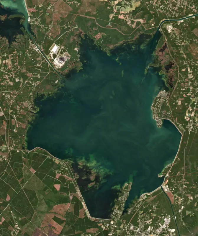
The satellite sees a likely bloom on part of the lake. Avoid discolored water and scum, and keep dogs out of it. About 421,000 cells/mL at the worst spot, covering less than 1% of the lake.
Week of Aug 9Week of Nov 1
Each bar is one week, colored by the worst reading of that week.
From the U.S. EPA's Cyanobacteria Assessment Network (CyAN), which reads the color of lakes from the Sentinel-3 satellites; it sees open water only, not coves or the shoreline. Blooms can be patchy: what you see on the water matters more. Swimming closures and health advisories come from South Carolina health and environment agencies. How to read it
Surface water temperature
65°F on Nov 12, 2026
86°F · Jul 2165°F · Nov 12
21°F cooler than on Jul 21, 2026.
Estimated from MODIS Aqua (NASA) passes on clear days: the top layer of the water, a few degrees either way. Coves and the shallows can be warmer.
Lake Moultrie water temperature: trend, swimming and the fish →
On or near the shore of Lake Moultrie: 13 boat ramps, 2 marinas, 2 rental outfits, 9 campgrounds, 3 beaches and 1 trail. The lake has about 221 miles of shoreline, counting its islands.
Tap an icon for details; use two fingers (or Ctrl + scroll) to move the map. Tap a dot for details. Map and lake outline © OpenStreetMap contributors. Places from OpenStreetMap, Overture Maps and Recreation.gov. Not for navigation.
What you’ll find on the shore
← AllBoating 15
← AllRentals & tours 2
← AllFishing spots 2
← AllBeaches 3
← AllCamping 9
← AllLodging 4
← AllTrails 1
← AllParks 3
← AllDining 2
These invasive plants and animals have been recorded in Lake Moultrie: clean, drain and dry everything before you go to another lake.
South Carolina: South Carolina has no clean-drain-dry law for boats, but it is illegal to possess hydrilla, water hyacinth and other listed aquatic plants or put them in state waters, so strip off all plant fragments. Officials urge boaters to clean, drain and dry before moving to another lake. State rules
Records: USGS Nonindigenous Aquatic Species database. A species not listed may still be present.
Species with open-licensed records inside Lake Moultrie's outline, from GBIF.org (surveys, museum collections and angler reports). A record shows a fish was found here, not how many there are now.
Shallow, protected flats in spring; docks, grass and deep edges in summer heat.
Brush piles, docks and bridge pilings; shallow for a few weeks in spring.
Channel edges and river arms; best after dark in summer, and after a rain.
Run up the river arms in spring; follow shad to cool, deep water near the dam in summer.
Schools near the bottom; best in the cool months.
Water temperature sets off each spawn; the bars show the usual months at this latitude and elevation, and move with a warm or cold spring. The water is about 65°F now.
Lake Moultrie is the lower of the two Santee Cooper lakes, a wide, shallow reservoir in Berkeley County in the South Carolina Lowcountry, with Moncks Corner, Bonneau Beach, Cross and St. Stephen near its shores. It is the third largest lake in the state, named for Governor William Moultrie, and it is known for giant catfish, landlocked striped bass and a lock that lifts boats 75 feet.
In April 1934 Governor Blackwood signed the bill creating the South Carolina Public Service Authority, now Santee Cooper, to build Lake Marion, Lake Moultrie and a hydroelectric plant to bring power to the rural Lowcountry. Work began in 1939. It was the largest Works Progress Administration project east of the Mississippi and the biggest land-clearing effort in the nation. More than 12,500 workers spent 27 months clearing swamp and forest and building dams, dikes, a powerhouse and a navigation lock. In 1941 President Roosevelt named the Pinopolis power plant a national defense project, and on February 17, 1942, it made its first electricity, for a North Charleston defense contractor. The plant now carries the name of Richard M. Jefferies, briefly governor in 1942 and Santee Cooper's general manager for 21 years.
Much of the old landscape went under the water. Most of the lake bed was timbered first, but stumps still line the gently sloping shores. The Santee Canal, chartered in 1786 and opened in 1800 to link the Santee and Cooper rivers, largely lies beneath the lake. Black Oak Church was torn down in 1941 after its graves were moved to St. Stephen's Episcopal Church and a cemetery near Bonneau, and its ruins rest on the lake bottom.
Lake Moultrie gets its water not from the Cooper River's own headwaters but from the Santee. The Santee fills Lake Marion upstream, and a diversion canal carries the water into Moultrie. From 1942 the flow left through Pinopolis Dam into the Cooper River, but the added flow caused heavy shoaling in Charleston Harbor, and from the 1950s through the 1970s the Army Corps of Engineers had to dredge it every year. Congress approved the Cooper River Rediversion Project in 1978, and since 1985 a canal and hydroelectric dam near St. Stephen have sent most of the Santee's water back to its own river. A fish lift there passes hundreds of thousands of American shad and blueback herring each year.
At Pinopolis Dam, the lock raises boats 75 feet between the Tailrace Canal and the lake, the highest single-lift lock in the world when it was built. It takes motorized boats from 10 to 150 feet long, closes in thunderstorms and rough water, and is part of a marked waterway that runs 162 miles from Columbia to Charleston. Manatees sometimes show up near the lock and in the Cooper River in the warmer months.
When the gates closed in 1941, striped bass were trapped above the new dams, creating a landlocked striper fishery. Their numbers have dropped in recent years, but restoration work has helped. Blue and flathead catfish were introduced in the mid-1960s and now grow very large here, and the lake produced a 58-pound world-record channel catfish. Largemouth bass and shellcracker draw anglers each spring, and the Hatchery section and backwater sloughs hold weeds, pickerel and bream. The state counts eight boat ramps and keeps 19 fish attractors on the lake.
The open lake is 14 miles across at its widest, and a marked channel runs from Pinopolis Dam to the Diversion Canal. Away from it, watch for stumps near shore, and never dive, because changing water levels and hidden stumps make it dangerous.
Written by Lake by Lake from Santee Cooper (Honoring 80 Years of Santee Cooper Power Generation, Santee Cooper Lakes), South Carolina Department of Natural Resources (Lake Moultrie, History of the St. Stephen Fish Lift), SC Picture Project and Wikipedia. Checked November 2026.
Cooper Dev - Pinopolis Dam is an earthfill dam 75 feet high and 50,072 feet long on the Cooper, completed in 1942. It belongs to South Carolina Public Service Authority and is run for flood control, navigation, recreation, hydropower and water supply. At its normal level the reservoir holds 1.11 million acre-ft, drained from 15,000 square miles of land.
From the National Inventory of Dams (U.S. Army Corps of Engineers), NID ID SC01076. Lake or reservoir: what’s the difference?
Where the level comes from: LK MOULTRIE AT REDIVERSION NR RUSSELLVILLE, SC (U.S. Geological Survey, used on this page) and LAKE MOULTRIE NEAR PINOPOLIS, SC (U.S. Geological Survey).
| Lake | Miles | Level (ft) | vs full | 7 days |
|---|---|---|---|---|
| Lake Marion Live reading | 10 | 73.23 | — | −0.19 |
| Lake Wateree Slightly below full | 76 | 97.68* | −2.32 | −0.35 |
| Lake Murray Below full | 84 | 351.92 | −8.08 | −0.62 |
* Local gauge datum: 100 ft = full pond (Duke Energy lakes).
Compare Lake Moultrie with Lake Marion, Lake Wateree or Lake Murray: size, level, ramps and fish side by side.
Lake Moultrie is at 73.13 feet above sea level, as of Nov 19, 2026, 5:00 AM EST. It has dropped 0.46 ft in the past 7 days.
Lake Moultrie has 13 boat ramps on our map, including Amos Gourdine Landing, Augustus M. Flood, Jr. boat landing, Boat ramp at Angel's Landing Marina, and 2 marinas. Low water can close ramps, so check today's level above and the operator before you go.
Yes. There are 9 campgrounds and RV parks within about a mile of the shore, such as Lake Moultrie SC, Johnston Landing Rv Lake Resort, Unhitched Lake Moultrie RV Park.
Game fish recorded in Lake Moultrie include striped bass, channel catfish, largemouth bass, bluegill, white catfish, flathead catfish. In all, 28 fish species have open records inside the lake on GBIF.
The surface of Lake Moultrie was about 65°F on November 12, estimated from a satellite pass on a clear day. It is the top layer of the water, a few degrees either way; coves and shallows run warmer in the sun.
Anglers 16 and older need a South Carolina fishing license, sold online by the South Carolina Department of Natural Resources. Free fishing days: Memorial Day and July 4 (residents, freshwater only). Size and bag limits can be set lake by lake: check the current regulations.
Lake Moultrie averages about 19 ft deep. Depth changes with the lake level.
In summer a white Secchi disk lowered into Lake Moultrie stays visible to about 5.0 ft (the median of 236 readings, 2016–2025, by Santee Cooper - South Carolina Public Service Authority and South Carolina Department of Environmental Services): somewhat murky water. With the algae measured too (chlorophyll about 7 µg/L), that makes it eutrophic: rich in nutrients, greener water. Clarity drops after storms and during algae blooms.
Yes: bathymetric map from the U.S. Geological Survey (1985). It is linked in the lake facts on this page. Depths on a map are measured at a reference level: subtract how far the lake is below it today.
boating (13 boat ramps and 2 marinas), kayaks, boats & jet skis (2 rental outfits on or near the water), fishing (16 game fish), swimming (3 beaches and swimming areas), hiking & walking (1 trail along the shore, the longest Palmetto Trail: Lake Moultrie Passage (27 mi)) and camping (9 campgrounds), according to our map of the shore.
EPA's CyAN satellite rated cyanobacteria in Lake Moultrie high on November 8. The satellite sees open water only; blooms can be patchy, so avoid water that looks like spilled paint or pea soup and keep dogs out of scum. Swimming advisories come from South Carolina health and environment agencies.
Yes. A trail runs along or near the shore, including Palmetto Trail: Lake Moultrie Passage (27 mi), according to OpenStreetMap.
Lake Moultrie is held back by Cooper Dev - Pinopolis Dam, completed in 1942 and 75 ft high, according to the National Inventory of Dams.
From the U.S. Geological Survey (LK MOULTRIE AT REDIVERSION NR RUSSELLVILLE, SC). Lake by Lake checks it every hour; the agency's own figure is always the reference, and provisional readings can be revised.
Lake levels are refreshed every hour. Texas and California reservoirs report once a day; most USGS and NOAA gauges report every 15 to 60 minutes.
Cookies for analytics With your OK we use Google Analytics and Microsoft Clarity to count visits and see how the site is used, so we can make it better. No advertising cookies. Privacy policy