Sun
- Sunrise
- 7:01 AM
- Sunset
- 5:18 PM
- First light
- 6:34 AM
- Last light
- 5:45 PM
Reservoir · Lexington County, South Carolina
A reservoir on the Saluda in Lexington County, South Carolina, held back by Saluda Dam since 1930.

Lake Murray is at 351.91 feet above sea level — 8.09 ft below full pool, as of Nov 19, 2026, 3:45 AM EST. It has dropped 0.63 ft in the past 7 days.
2nd fullest of 4 South Carolina lakes today against full pool · See the ranking
A notification from this browser, once, when the level crosses the line (checked every hour). No account and no email. On an iPhone, add Lake by Lake to your home screen first (Share → Add to Home Screen) and open it from there. Or follow the lake in a feed reader: RSS feed.
Lake Murray is down 0.63 ft over the last 7 days, at 351.91 ft today.
Daily values from the U.S. Geological Survey.
Lake Murray is down 2.30 ft over the last 30 days, at 351.91 ft today.
Daily values from the U.S. Geological Survey.
Over the past 12 months, Lake Murray ranged from 351.99 ft (Nov 18, 2026) to 356.39 ft (Jun 4, 2026), a swing of 4.4 ft. Today's level is the lowest of the past 12 months. It is 2.73 ft lower than on this date last year.
Daily values from the U.S. Geological Survey. Why lake levels rise and fall
Solunar periods for Lake Murray, local time. How they work
Low · as of Nov 9, 2026
Some cyanobacteria at the surface, under 100,000 cells/mL. About 37,000 cells/mL at the worst spot, covering less than 1% of the lake.
Week of Aug 16Week of Nov 1
Each bar is one week, colored by the worst reading of that week.
From the U.S. EPA's Cyanobacteria Assessment Network (CyAN), which reads the color of lakes from the Sentinel-3 satellites; it sees open water only, not coves or the shoreline. Blooms can be patchy: what you see on the water matters more. Swimming closures and health advisories come from South Carolina health and environment agencies. How to read it
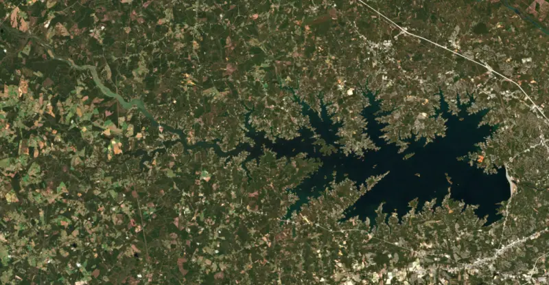
Surface water temperature
63°F on Nov 16, 2026
85°F · Jul 2863°F · Nov 16
21°F cooler than on Jul 28, 2026.
Estimated from MODIS Aqua (NASA) passes on clear days: the top layer of the water, a few degrees either way. Coves and the shallows can be warmer.
Lake Murray water temperature: trend, swimming and the fish →
On or near the shore of Lake Murray: 38 boat ramps, 21 marinas, 11 rental outfits, 7 campgrounds, 4 beaches, 2 trails and 1 fishing guide. The lake has about 626 miles of shoreline, counting its islands.
Tap an icon for details; use two fingers (or Ctrl + scroll) to move the map. Tap a dot for details. Map and lake outline © OpenStreetMap contributors. Places from OpenStreetMap, Overture Maps and Recreation.gov. Not for navigation.
What you’ll find on the shore
← AllBoating 59
← AllRentals & tours 16
← AllFishing spots 4
← AllBeaches 4
← AllCamping 7
← AllLodging 14
← AllTrails 2
← AllParks 3
← AllDining 24+
These invasive plants and animals have been recorded in Lake Murray: clean, drain and dry everything before you go to another lake.
South Carolina: South Carolina has no clean-drain-dry law for boats, but it is illegal to possess hydrilla, water hyacinth and other listed aquatic plants or put them in state waters, so strip off all plant fragments. Officials urge boaters to clean, drain and dry before moving to another lake. State rules
Records: USGS Nonindigenous Aquatic Species database. A species not listed may still be present.
Species with open-licensed records inside Lake Murray's outline, from GBIF.org (surveys, museum collections and angler reports). A record shows a fish was found here, not how many there are now.
Channel edges and river arms; best after dark in summer, and after a rain.
Run up the river arms in spring; follow shad to cool, deep water near the dam in summer.
Schools near the bottom; best in the cool months.
Shallow weedbeds and docks; nests closer to shore and shallower than bluegill.
Shallow, muddy bays and flooded grass in spring; mud flats and inflows in summer.
Water temperature sets off each spawn; the bars show the usual months at this latitude and elevation, and move with a warm or cold spring. The water is about 63°F now.
Lake Murray is the reservoir on the Saluda River near Columbia, spread across Lexington, Richland, Newberry and Saluda counties in the South Carolina Midlands. Built for hydropower in the late 1920s, it is known for striped bass, a huge summer gathering of purple martins and the long earthen dam that holds it back.
The idea started in 1923, when Thomas Clay Williams brought his plans for a Saluda River power project to the engineers William S. Murray and Henry Flood Jr. Murray's team turned a modest proposal into a far larger system, and the lake carries his name. The Federal Power Commission licensed the dam at Dreher Shoals in 1927, and it was built between 1927 and 1930. Crews used steam shovels, rail cars dumping fill from wooden trestles, and water cannons that washed clay into a tight core. When it was finished it was the largest earthfill dam in the country, and it is still the largest dam in South Carolina. Students from The Citadel and the University of South Carolina worked on the design.
The Saluda valley had been farmed since German and Swiss settlers arrived in the 1750s, and the area known as the Dutch Fork was densely settled by 1760. The power company bought about 1,100 parcels, a purchase that touched some 5,000 people. In 1928 the valley held 3 churches, 6 schools and 193 graveyards, and 2,323 graves were moved. About 2,000 men cleared the basin between 1927 and 1928, running 37 sawmills, and nearly all the lumber for the dam came from that clearing. Seismic studies later showed the old dam needed help in a strong earthquake, and from 2002 to 2005 a roller-compacted concrete backup dam was built at its downstream toe. A public walkway crosses the dam, with recreation areas at both ends. Every few years Dominion Energy, working with the state, lowers the lake about 8 feet through the winter to control aquatic plants and let owners repair docks, and boaters are told to take extra care in shallow coves.
During World War II the Columbia Army Air Base trained B-25 crews, and pilots from the Doolittle Raid practiced over the lake. Several bombers went down in it, and one was raised in September 2005 and taken to the Southern Museum of Flight in Birmingham, Alabama. Bomb Island, also called Lunch Island, is a 12-acre clay island that has become a summer roost for hundreds of thousands of purple martins. The birds pour in at dusk in July and August, the flock shows up on weather radar, and the island is under the care of the Department of Natural Resources. Landing on it is forbidden, so people watch from boats. In the northwest corner, Dreher Island State Park spreads over three islands.
The lake's popular fish include largemouth and striped bass, blue and channel catfish, crappie and redear sunfish. In late summer the lake stratifies, the warm surface pushes stripers into deep water that runs short of oxygen, and some die each year, as they have since 1973. The state says fish caught alive are safe to eat and urges anglers to keep their summer catch, since most stripers released in summer do not survive. Below the dam, cold water drawn from the bottom of the lake lets the lower Saluda River hold rainbow and brown trout. The state stocks about 30,000 each winter, and the reach from the eastbound I-20 bridge down to Stacey's Ledge is catch-and-release only.
Written by Lake by Lake from American Society of Civil Engineers, South Carolina Department of Natural Resources (Striped bass die-off expected at Lake Murray, Trout stocking in the lower Saluda River), South Carolina Public Radio, South Carolina ETV and Wikipedia. Checked November 2026.
Saluda Dam is an earthfill dam 213 feet high and 7,800 feet long on the Saluda, completed in 1930. It belongs to South Carolina Electric and Gas Company and is run for hydropower. At its normal level the reservoir holds 2.10 million acre-ft, drained from 2,420 square miles of land.
From the National Inventory of Dams (U.S. Army Corps of Engineers), NID ID SC00224. Lake or reservoir: what’s the difference?
Where the level comes from: LAKE MURRAY NEAR COLUMBIA, SC (U.S. Geological Survey, used on this page) and Lake Murray (NOAA National Water Prediction Service).
| Lake | Miles | Level (ft) | vs full | 7 days |
|---|---|---|---|---|
| Parr Reservoir Live reading | 16 | 262.29 | — | −1.05 |
| Monticello Reservoir Live reading | 18 | 422.96 | — | +0.46 |
| Lake Wateree Slightly below full | 35 | 97.68* | −2.32 | −0.35 |
| Cedar Creek Reservoir At or near full pool | 39 | 98.55* | −1.45 | −0.26 |
| Great Falls Reservoir Slightly below full | 40 | 96.21* | −3.79 | −0.55 |
| Lake Greenwood Live reading | 40 | 437.31 | — | −0.43 |
* Local gauge datum: 100 ft = full pond (Duke Energy lakes).
Compare Lake Murray with Parr Reservoir, Monticello Reservoir, Lake Wateree or Cedar Creek Reservoir: size, level, ramps and fish side by side.
Lake Murray is about 18 mi from Columbia, SC. See all the lakes near each city.
Lake Murray is at 351.91 feet above sea level — 8.09 ft below full pool, as of Nov 19, 2026, 3:45 AM EST. It has dropped 0.63 ft in the past 7 days.
Lake Murray's full pool is 360.00 ft, according to Dominion Energy. Today the lake is 8.09 ft below that mark.
Lake Murray has 38 boat ramps on our map, including Boat ramp at Hollow Creek Marina & Store, Boat ramp at Lake Murray Resort and Marina, Boat ramp at Southshore Marina, and 21 marinas. Low water can close ramps, so check today's level above and the operator before you go.
Yes. There are 7 campgrounds and RV parks within about a mile of the shore, such as Dreher Island Site #78, Prices Bridge Inn, Acapulco-USA Campground.
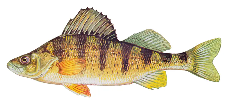
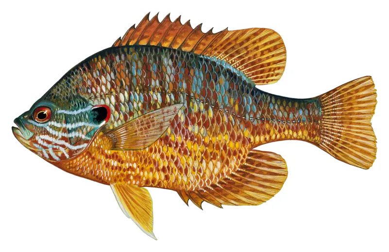
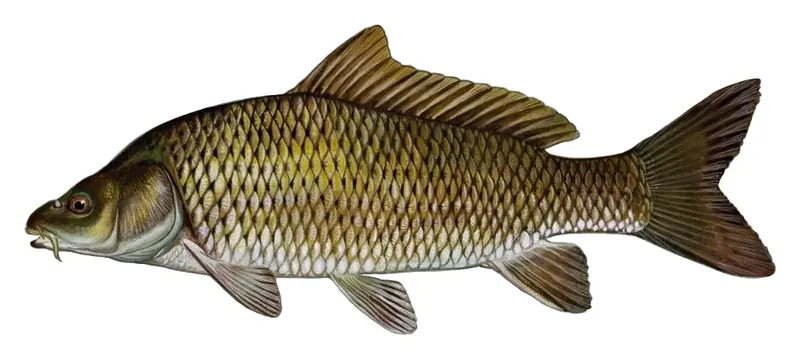
Game fish recorded in Lake Murray include white catfish, flathead catfish, striped bass, yellow perch, pumpkinseed, common carp. In all, 8 fish species have open records inside the lake on GBIF.
The surface of Lake Murray was about 63°F on November 16, estimated from a satellite pass on a clear day. It is the top layer of the water, a few degrees either way; coves and shallows run warmer in the sun.
Anglers 16 and older need a South Carolina fishing license, sold online by the South Carolina Department of Natural Resources. Free fishing days: Memorial Day and July 4 (residents, freshwater only). Size and bag limits can be set lake by lake: check the current regulations.
Lake Murray averages about 44 ft deep. Depth changes with the lake level.
In summer a white Secchi disk lowered into Lake Murray stays visible to about 3.9 ft (the median of 376 readings, 2017–2026, by South Carolina Department of Environmental Services): somewhat murky water. With the algae measured too (chlorophyll about 11 µg/L), that makes it eutrophic: rich in nutrients, greener water. Clarity drops after storms and during algae blooms.
boating (38 boat ramps and 21 marinas), kayaks, boats & jet skis (11 rental outfits on or near the water), boat tours (5 boat tours and charters), fishing (6 game fish and 1 fishing guide), swimming (4 beaches and swimming areas) and hiking & walking (2 trails along the shore, the longest Greenway Trial (2.2 mi)), according to our map of the shore.
EPA's CyAN satellite rated cyanobacteria in Lake Murray low on November 9. The satellite sees open water only; blooms can be patchy, so avoid water that looks like spilled paint or pea soup and keep dogs out of scum. Swimming advisories come from South Carolina health and environment agencies.
Yes. 2 trails run along or near the shore, including Little Gap Trail (1.4 mi) and Greenway Trial (2.2 mi), according to OpenStreetMap.
Lake Murray is held back by Saluda, completed in 1930 and 213 ft high, according to the National Inventory of Dams.
From the U.S. Geological Survey (LAKE MURRAY NEAR COLUMBIA, SC). Lake by Lake checks it every hour; the agency's own figure is always the reference, and provisional readings can be revised.
Lake levels are refreshed every hour. Texas and California reservoirs report once a day; most USGS and NOAA gauges report every 15 to 60 minutes.
Cookies for analytics With your OK we use Google Analytics and Microsoft Clarity to count visits and see how the site is used, so we can make it better. No advertising cookies. Privacy policy