Sun
- Sunrise
- 7:02 AM
- Sunset
- 5:16 PM
- First light
- 6:35 AM
- Last light
- 5:43 PM
Reservoir · York County, South Carolina
A reservoir on the Catawba in North Carolina and South Carolina, held back by Wylie Dam since 1925.

Lake Wylie is at 97.15 ft on its local gauge — 2.85 ft below full pond (local datum), as of Nov 19, 2026, 6:00 AM EST. It has dropped 0.26 ft in the past 7 days.
Lake Wylie is down 0.26 ft over the last 7 days, at 97.15 ft today.
Daily values from the NOAA National Water Prediction Service.
Lake Wylie is down 0.87 ft over the last 30 days, at 97.15 ft today.
Daily values from the NOAA National Water Prediction Service. Why lake levels rise and fall
Solunar periods for Lake Wylie, local time. How they work
Not detected · as of Nov 9, 2026
The satellite found no cyanobacteria at the surface.
Week of Aug 9Week of Nov 1
Each bar is one week, colored by the worst reading of that week.
From the U.S. EPA's Cyanobacteria Assessment Network (CyAN), which reads the color of lakes from the Sentinel-3 satellites; it sees open water only, not coves or the shoreline. Blooms can be patchy: what you see on the water matters more. Swimming closures and health advisories come from South Carolina health and environment agencies. How to read it
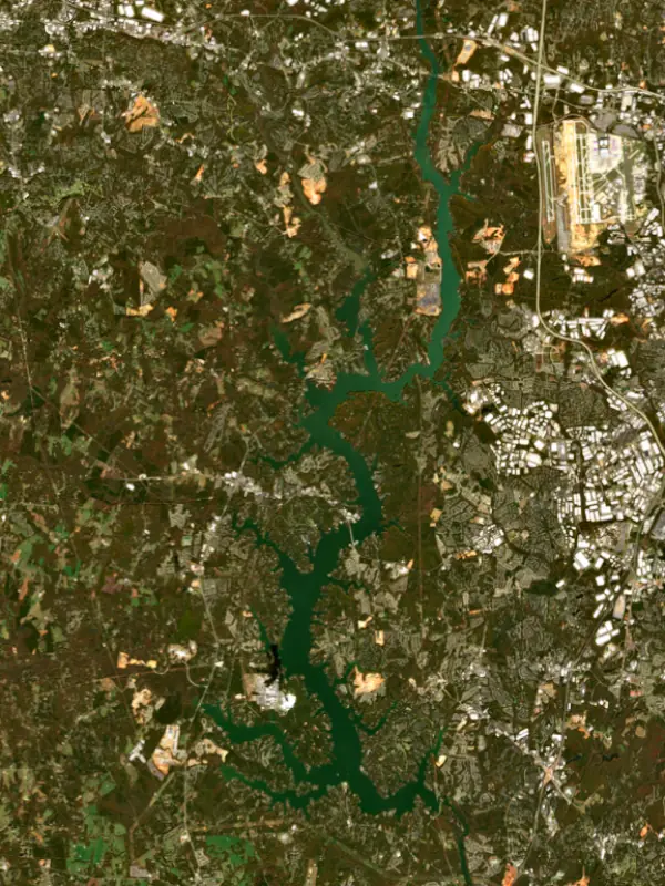
Surface water temperature
66°F on Nov 9, 2026
71°F · Aug 1366°F · Nov 9
5°F cooler than on Aug 13, 2026.
Estimated from Landsat 8/9 (USGS) passes on clear days: the top layer of the water, a few degrees either way. Coves and the shallows can be warmer.
Lake Wylie water temperature: trend, swimming and the fish →
On or near the shore of Lake Wylie: 15 boat ramps, 12 marinas, 6 rental outfits, 6 campgrounds, 6 beaches, 1 fishing pier and 7 trails. The lake has about 254 miles of shoreline, counting its islands.
Tap an icon for details; use two fingers (or Ctrl + scroll) to move the map. Tap a dot for details. Map and lake outline © OpenStreetMap contributors. Places from OpenStreetMap, Overture Maps and Recreation.gov. Not for navigation.
What you’ll find on the shore
← AllBoating 27
← AllRentals & tours 7
← AllFishing spots 4
← AllBeaches 6
← AllCamping 6
← AllLodging 9
← AllTrails 7
← AllParks 12
← AllDining 11
These invasive plants and animals have been recorded in Lake Wylie: clean, drain and dry everything before you go to another lake.
North Carolina: North Carolina has no clean-drain-dry law for boaters. The Wildlife Resources Commission urges you to clean off plants, animals and mud, drain all water, dry your gear, and never move fish or plants from one water to another. State rules
South Carolina: South Carolina has no clean-drain-dry law for boats, but it is illegal to possess hydrilla, water hyacinth and other listed aquatic plants or put them in state waters, so strip off all plant fragments. Officials urge boaters to clean, drain and dry before moving to another lake. State rules
Records: USGS Nonindigenous Aquatic Species database. A species not listed may still be present.
Species with open-licensed records inside Lake Wylie's outline, from GBIF.org (surveys, museum collections and angler reports). A record shows a fish was found here, not how many there are now.
Brush piles, docks and bridge pilings; shallow for a few weeks in spring.
Channel edges and river arms; best after dark in summer, and after a rain.
Run up the river arms in spring; follow shad to cool, deep water near the dam in summer.
Spring runs up the tributaries; schools busting shad in late summer.
On the bottom near snail beds; spawns around the full moon.
Water temperature sets off each spawn; the bars show the usual months at this latitude and elevation, and move with a warm or cold spring. The water is about 66°F now.
Lake Wylie is a Duke Energy reservoir on the Catawba River, straddling the North Carolina and South Carolina line between Charlotte and Rock Hill. It is the oldest lake on the river. Tega Cay and the community of Lake Wylie sit on its South Carolina shore, and Charlotte, Fort Mill and Rock Hill are all close by.
The first dam went up here in 1904, near Fort Mill, built by the Catawba Power Company to make electricity. Its powerhouse, later known as Old Catawba, turned its generators with a rope-driven water wheel and supplied nearby mills, and the lake behind it is one of the oldest reservoirs in South Carolina. The man behind it was Dr. W. Gil Wylie, who had seen the early power work at Niagara Falls and wanted to bring industry to the area around his hometown of Chester. He organized the Catawba Power Company and went on to become the first president of the Southern Power Company, which he founded with James Buchanan Duke and the engineer William States Lee and which grew into Duke Energy.
The dam was rebuilt in 1924, giving the lake roughly its present shoreline, and a new hydro station replaced Old Catawba and began running in 1925. In 1960 the lake and the station were renamed for Dr. Wylie. The river itself carries the name of the Catawba people.
The upper part of the lake lies in North Carolina, in Gaston and Mecklenburg counties, and most of the lower part in York County, South Carolina. Besides the Catawba itself, the main streams feeding it are the South Fork Catawba River, Crowders Creek, Catawba Creek and Allison Creek. The Wylie station is one of 13 Duke Energy hydro plants on the Catawba-Wateree chain.
On the North Carolina side, Mecklenburg County's McDowell Nature Preserve in southwestern Charlotte has trails along the water, among them the Cove Trail, which follows the ledges above the lake, and the Kingfisher Trail, which leads down to the waterfront at the nature center. On the South Carolina side, Ebenezer Park in York County offers bank fishing, and Duke Energy, the South Carolina Department of Natural Resources and York County share the upkeep of the public boat access areas.
Lake Wylie has always been a working lake. Besides the Wylie hydro station at the dam, it has supplied cooling water to two large power plants. Allen Steam Station, a coal plant at Belmont in Gaston County, ran from 1957 until Duke retired it in December 2024, and a large battery storage system now stands on the site. Catawba Nuclear Station sits beside the lake in York County. The lake also supplies drinking water to Rock Hill and Belmont.
The South Carolina Department of Natural Resources manages Lake Wylie for recreational fishing, and its biologists keep watch on the three species most anglers come for: largemouth bass, crappie and catfish. The department maintains six fish attractors in the lake to give fish cover. North Carolina's water quality monitors have found the lake rich in nutrients for as long as they have sampled it, since 1981, and the North Carolina part of the lake is listed as impaired because of an advisory on PCBs in fish, so anglers who keep their catch should check the state's fish consumption advice first.
In 2008 the conservation group American Rivers named the Catawba-Wateree the most endangered river in America, pointing to fast population growth around Charlotte and outdated water management in both Carolinas.
Written by Lake by Lake from South Carolina Department of Natural Resources (Lake Wylie description, An Overview of the Eight Major River Basins of South Carolina), Duke Energy (Go behind the scenes at Wylie Hydro Station, Duke Energy brings new grid battery on line at former Allen coal plant), North Carolina Department of Environmental Quality, Division of Water Resources and Mecklenburg County. Checked November 2026.
Wylie Dam is a concrete gravity dam 119 feet high and 3,232 feet long on the Catawba, completed in 1925. It belongs to Duke Energy and is run for hydropower, recreation and water supply. At its normal level the reservoir holds 229,200 acre-ft, drained from 3,020 square miles of land.
From the National Inventory of Dams (U.S. Army Corps of Engineers), NID ID SC00687. Lake or reservoir: what’s the difference?
Where the level comes from: Catawba River at Lake Wylie Dam (NOAA National Water Prediction Service).
| Lake | Miles | Level (ft) | vs full | 7 days |
|---|---|---|---|---|
| Mountain Island Lake Slightly below full | 22 | 96.81* | −3.19 | −0.10 |
| Ninety Nine Islands Reservoir Live reading | 27 | 510.86 | — | +0.02 |
| Lake Norman Slightly below full | 29 | 96.54* | −3.46 | −0.21 |
| Fishing Creek Reservoir At or near full pool | 30 | 98.64* | −1.36 | +0.37 |
| Great Falls Reservoir Slightly below full | 33 | 96.14* | −3.86 | −0.62 |
| Cedar Creek Reservoir At or near full pool | 34 | 98.84* | −1.16 | +0.03 |
* Local gauge datum: 100 ft = full pond (Duke Energy lakes).
Compare Lake Wylie with Mountain Island Lake, Ninety Nine Islands Reservoir, Lake Norman or Fishing Creek Reservoir: size, level, ramps and fish side by side.
Lake Wylie is about 16 mi from Charlotte, NC, 33 mi from Concord, NC and 88 mi from High Point, NC. See all the lakes near each city.
Lake Wylie is at 97.15 ft on its local gauge — 2.85 ft below full pond (local datum), as of Nov 19, 2026, 6:00 AM EST. It has dropped 0.26 ft in the past 7 days.
Lake Wylie's full pond (local datum) is 100 ft (local datum), according to Duke Energy local datum: 100 ft = full pond. Today the lake is 2.85 ft below that mark.
Lake Wylie has 15 boat ramps on our map, including Allison Creek, Boat ramp near Kevin Loftin Riverfront Park, Long Cove Slipway, and 12 marinas. Low water can close ramps, so check today's level above and the operator before you go.
Yes. There are 6 campgrounds and RV parks within about a mile of the shore, such as Elks park, Ebenezer Park, YMCA Camp Thunderbird.
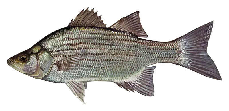
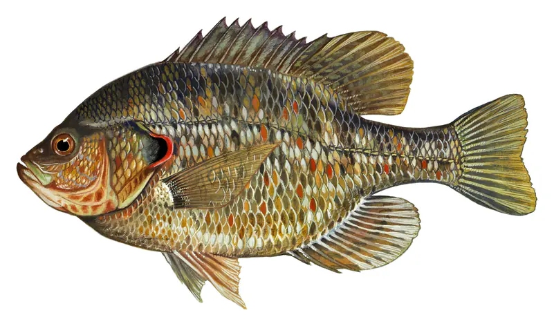
Game fish recorded in Lake Wylie include black crappie, white crappie, white catfish, striped bass, white bass, redear sunfish. In all, 22 fish species have open records inside the lake on GBIF.
The surface of Lake Wylie was about 66°F on November 9, estimated from a satellite pass on a clear day. It is the top layer of the water, a few degrees either way; coves and shallows run warmer in the sun.
Lake Wylie lies in North Carolina and South Carolina: the license of the state where you fish applies. Anglers 16 and older need a North Carolina fishing license, sold online by the North Carolina Wildlife Resources Commission. Free fishing days: July 4. Anglers 16 and older need a South Carolina fishing license, sold online by the South Carolina Department of Natural Resources. Free fishing days: Memorial Day and July 4 (residents, freshwater only). Size and bag limits can be set lake by lake: check the current regulations.
NOAA's flood categories for the Lake Wylie gauge: action stage at 100.0 ft, minor flooding at 102.0 ft, moderate flooding at 105.0 ft and major flooding at 110.0 ft. Today the lake is 4.85 ft below the first flooding level.
Lake Wylie averages about 19 ft deep. Depth changes with the lake level.
In summer a white Secchi disk lowered into Lake Wylie stays visible to about 4.6 ft (the median of 128 readings, 2016–2026, by South Carolina Department of Environmental Services and North Carolina Dept of Environmental Quality NCDEQ-DWR WQX): somewhat murky water. With the algae measured too (chlorophyll about 12 µg/L), that makes it eutrophic: rich in nutrients, greener water. Clarity drops after storms and during algae blooms.
boating (15 boat ramps and 12 marinas), kayaks, boats & jet skis (6 rental outfits on or near the water), boat tours (1 boat tour or charter), fishing (9 game fish and 1 fishing pier or spot), swimming (6 beaches and swimming areas) and hiking & walking (7 trails along the shore, the longest Seven Oaks Preserve Trail (2.6 mi)), according to our map of the shore.
EPA's CyAN satellite rated cyanobacteria in Lake Wylie not detected on November 9. The satellite sees open water only; blooms can be patchy, so avoid water that looks like spilled paint or pea soup and keep dogs out of scum. Swimming advisories come from South Carolina health and environment agencies.
Yes. 7 trails run along or near the shore, including Cove Trail (0.6 mi), Kingfisher Trail (1.1 mi) and Seven Oaks Preserve Trail (2.6 mi), according to OpenStreetMap.
Lake Wylie is held back by Wylie, completed in 1925 and 119 ft high, according to the National Inventory of Dams.
From the NOAA National Water Prediction Service (Catawba River at Lake Wylie Dam). Lake by Lake checks it every hour; the agency's own figure is always the reference, and provisional readings can be revised.
Lake levels are refreshed every hour. Texas and California reservoirs report once a day; most USGS and NOAA gauges report every 15 to 60 minutes.
Cookies for analytics With your OK we use Google Analytics and Microsoft Clarity to count visits and see how the site is used, so we can make it better. No advertising cookies. Privacy policy