Sun
- Sunrise
- 7:17 AM
- Sunset
- 5:05 PM
- First light
- 6:47 AM
- Last light
- 5:35 PM
Reservoir · Wasatch County, Utah
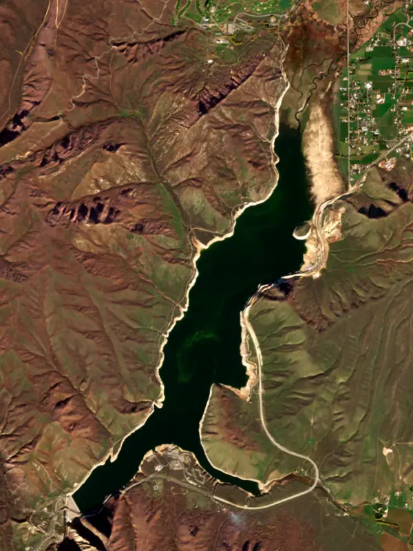
A reservoir on the Provo River in Wasatch County, Utah, held back by Deer Creek Dam since 1941.
Deer Creek Reservoir is at 5,383.52 feet above sea level, as of Nov 17, 2026.
Lowest of 6 Utah lakes today against normal for the date · See the ranking
Record low 5,356.02 ft (1961), record high 5,418.50 ft (1974) · Level history since 1957
A notification from this browser, once, when the level crosses the line (checked every hour). No account and no email. On an iPhone, add Lake by Lake to your home screen first (Share → Add to Home Screen) and open it from there. Or follow the lake in a feed reader: RSS feed.
Deer Creek Reservoir is up 3.34 ft over the last 30 days, at 5,383.52 ft today.
Daily values from the Bureau of Reclamation (Upper Colorado).
Over the past 12 months, Deer Creek Reservoir ranged from 5,378.04 ft (Sep 17, 2026) to 5,411.68 ft (Apr 29, 2026), a swing of 33.6 ft. Today's level is near the bottom of that range. It is 14.64 ft lower than on this date last year.
Daily values from the Bureau of Reclamation (Upper Colorado). Why lake levels rise and fall
In the Bureau of Reclamation (Upper Colorado) record, which starts in 1957, the lowest level was 5,356.02 ft on September 17, 1961 and the highest 5,418.50 ft on June 17, 1974. Today’s 5,383.52 ft is 27.5 ft above the record low and 35.0 ft below the record high.
Deer Creek Reservoir level history: every year since 1957, the lowest and highest years →
Solunar periods for Deer Creek Reservoir, local time. How they work
High · as of Nov 9, 2026
The satellite sees a likely bloom on part of the lake. Avoid discolored water and scum, and keep dogs out of it. About 421,000 cells/mL at the worst spot, covering 45% of the lake.
Week of Aug 16Week of Nov 1
Each bar is one week, colored by the worst reading of that week.
From the U.S. EPA's Cyanobacteria Assessment Network (CyAN), which reads the color of lakes from the Sentinel-3 satellites; it sees open water only, not coves or the shoreline. Blooms can be patchy: what you see on the water matters more. Swimming closures and health advisories come from Utah health and environment agencies. How to read it
Surface water temperature
52°F on Nov 12, 2026
82°F · Jul 2352°F · Nov 12
29°F cooler than on Jul 23, 2026.
Estimated from Landsat 8/9 (USGS) passes on clear days: the top layer of the water, a few degrees either way. Coves and the shallows can be warmer.
Deer Creek Reservoir water temperature: trend, swimming and the fish →
On or near the shore of Deer Creek Reservoir: 2 boat ramps, 1 rental outfit and 2 trails. The lake has about 19 miles of shoreline, counting its islands.
Tap an icon for details; use two fingers (or Ctrl + scroll) to move the map. Tap a dot for details. Map and lake outline © OpenStreetMap contributors. Places from OpenStreetMap, Overture Maps and Recreation.gov. Not for navigation.
No aquatic invasive species are on record for Deer Creek Reservoir in the USGS database. Keep it that way: clean, drain and dry your boat between lakes.
Utah: Every boater, paddlers included, must take the Mussel-Aware Boater course each year, and motorboats need an annual AIS decal; pull drain plugs and sea strainers when leaving any water and while trailering. Boats leaving Lake Powell must be inspected, then professionally decontaminated or dried 7 to 30 days before launching elsewhere. Required: Mussel-Aware Boater course certificate; AIS decal (motorboats) (Course free; AIS decal $20 a year for Utah motorboats, $25 for nonresident motorboats). State rules
Records: USGS Nonindigenous Aquatic Species database. A species not listed may still be present.
Species with open-licensed records inside Deer Creek Reservoir's outline, from GBIF.org (surveys, museum collections and angler reports). A record shows a fish was found here, not how many there are now.
Shallow, protected flats in spring; docks, grass and deep edges in summer heat.
Rocky points, gravel and current breaks; deeper rock piles in summer.
Rocky shorelines at night after ice-out; deep weed edges and humps in summer.
Cool water: near the surface in spring and fall, deep in summer.
Low light and cold water; the inflows in fall.
Water temperature sets off each spawn; the bars show the usual months at this latitude and elevation, and move with a warm or cold spring. The water is about 52°F now.
Deer Creek Reservoir is a reservoir in Wasatch County, Utah. Lake by Lake tracks its level from the Bureau of Reclamation (Upper Colorado) and compares it with the readings of the past year.
Recreation at Deer Creek Dam and Reservoir, Provo River Project , is managed by the Utah Division of Parks and Recreation under agreement with the Bureau of Reclamation. Deer Creek Reservoir is situated in an open setting 7 miles southwest of Heber City, at an elevation of 5,420-feet. The reservoir has a surface area of 2,680 acres. The managed recreation season is April through November. This recreation area experiences heavy use. Fish species include rainbow trout, smallmouth bass, and largemouth bass.
Activities listed by the Bureau of Reclamation: Scenic drives · Biking · Boating · Camping · Fishing · Hiking · Picnicking · Winter sports · Water sports
Deer Creek Dam is an earthfill dam 240 feet high and 1,304 feet long on the Provo River, completed in 1941. It belongs to the Bureau of Reclamation and is run for irrigation. At its normal level the reservoir holds 152,570 acre-ft, drained from 557 square miles of land.
From the National Inventory of Dams (U.S. Army Corps of Engineers), NID ID UT10117. Lake or reservoir: what’s the difference?
Where the level comes from: Deer Creek Reservoir (Bureau of Reclamation (Upper Colorado), used on this page) and Deer Creek Reservoir Dam and Powerplant (Bureau of Reclamation (RISE)).
| Lake | Miles | Level (ft) | vs full | 7 days |
|---|---|---|---|---|
| Jordanelle Reservoir Well below full | 14 | 6116.89 | −52.11 | +0.38 |
| Utah Lake Slightly below full | 19 | 4484.82 | −4.23 | +0.22 |
| Currant Creek Reservoir At or near full pool | 25 | 7676.70 | −1.30 | −0.21 |
| Rockport Reservoir Well below full | 27 | 5996.64 | −40.36 | +0.54 |
| Strawberry Reservoir Well below full | 33 | 7585.74 | −16.66 | −0.03 |
| East Canyon Reservoir Well below full | 35 | 5664.05 | −40.95 | +0.46 |
Compare Deer Creek Reservoir with Jordanelle Reservoir, Utah Lake, Currant Creek Reservoir or Rockport Reservoir: size, level, ramps and fish side by side.
Deer Creek Reservoir is about 13 mi from Provo, UT, 28 mi from West Jordan, UT and 32 mi from West Valley City, UT. See all the lakes near each city.
Deer Creek Reservoir is at 5,383.52 feet above sea level, as of Nov 17, 2026.
Today's level is 13.93 ft below the median for this date (5,397.45 ft), from the gauge’s long-term daily record.
5,356.02 ft, on September 17, 1961, in the Bureau of Reclamation (Upper Colorado) record, which starts in 1957. Today the lake is 27.5 ft above that.
5,418.50 ft, on June 17, 1974, in the Bureau of Reclamation (Upper Colorado) record since 1957.
Deer Creek Reservoir has 2 boat ramps on our map, including Deer Creek Island, Deer Creek State Park. Low water can close ramps, so check today's level above and the operator before you go.
Game fish recorded in Deer Creek Reservoir include largemouth bass, smallmouth bass, walleye, rainbow trout, brown trout, kokanee salmon. In all, 9 fish species have open records inside the lake on GBIF.
The surface of Deer Creek Reservoir was about 52°F on November 12, estimated from a satellite pass on a clear day. It is the top layer of the water, a few degrees either way; coves and shallows run warmer in the sun.
Anglers 12 and older need a Utah fishing license, sold online by the Utah Division of Wildlife Resources. Free fishing days: Free Fishing Day, one Saturday in June (2026: June 6). Size and bag limits can be set lake by lake: check the current regulations.
Deer Creek Reservoir averages about 57 ft deep. Depth changes with the lake level.
In summer a white Secchi disk lowered into Deer Creek Reservoir stays visible to about 9.8 ft (the median of 116 readings, 2016–2025, by Utah Department Of Environmental Quality and UC Region of USBOR): clear water. With the algae measured too (chlorophyll about 4 µg/L), that makes it mesotrophic: moderately rich in nutrients. Clarity drops after storms and during algae blooms.
Bureau of Reclamation lists scenic drives, biking, boating, camping, fishing, hiking, picnicking and winter sports at Deer Creek Reservoir.
EPA's CyAN satellite rated cyanobacteria in Deer Creek Reservoir high on November 9. The satellite sees open water only; blooms can be patchy, so avoid water that looks like spilled paint or pea soup and keep dogs out of scum. Swimming advisories come from Utah health and environment agencies.
Yes. 2 trails run along or near the shore, including Deer Creek Trail (7.6 mi) and SoHo Rigdge Trail (1.3 mi), according to OpenStreetMap.
Deer Creek Reservoir is held back by Deer Creek Dam, completed in 1941 and 240 ft high, according to the National Inventory of Dams.
From the Bureau of Reclamation (Upper Colorado) (Deer Creek Reservoir). Lake by Lake checks it every hour; the agency's own figure is always the reference, and provisional readings can be revised.
Lake levels are refreshed every hour. Texas and California reservoirs report once a day; most USGS and NOAA gauges report every 15 to 60 minutes.
Cookies for analytics With your OK we use Google Analytics and Microsoft Clarity to count visits and see how the site is used, so we can make it better. No advertising cookies. Privacy policy




