Sun
- Sunrise
- 6:20 AM
- Sunset
- 4:39 PM
- First light
- 5:54 AM
- Last light
- 5:06 PM
Reservoir · Marshall County, Alabama
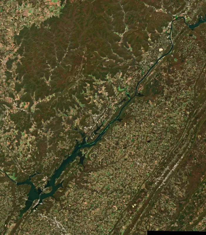
A reservoir on the Tennessee River in Marshall County, Alabama, held back by Guntersville Dam since 1939. Also called Guntersville Lake.

Lake Guntersville is at 593.62 feet above sea level — 1.38 ft below summer pool, as of Nov 17, 2026, 8:00 PM CST. It has dropped 0.43 ft in the past 7 days.
6th fullest of 13 Alabama lakes today against full pool · See the ranking
A notification from this browser, once, when the level crosses the line (checked every hour). No account and no email. On an iPhone, add Lake by Lake to your home screen first (Share → Add to Home Screen) and open it from there. Or follow the lake in a feed reader: RSS feed.
Lake Guntersville is down 0.05 ft over the last 30 days, at 593.62 ft today.
Daily values from the NOAA National Water Prediction Service. Why lake levels rise and fall
Solunar periods for Lake Guntersville, local time. How they work
High · as of Nov 9, 2026
The satellite sees a likely bloom on part of the lake. Avoid discolored water and scum, and keep dogs out of it. About 302,000 cells/mL at the worst spot, covering 4% of the lake.
Week of Aug 16Week of Nov 1
Each bar is one week, colored by the worst reading of that week.
From the U.S. EPA's Cyanobacteria Assessment Network (CyAN), which reads the color of lakes from the Sentinel-3 satellites; it sees open water only, not coves or the shoreline. Blooms can be patchy: what you see on the water matters more. Swimming closures and health advisories come from Alabama health and environment agencies. How to read it
Surface water temperature
60°F on Nov 14, 2026
90°F · Aug 1060°F · Nov 14
30°F cooler than on Aug 10, 2026.
Estimated from Landsat 8/9 (USGS) passes on clear days: the top layer of the water, a few degrees either way. Coves and the shallows can be warmer.
Lake Guntersville water temperature: trend, swimming and the fish →
On or near the shore of Lake Guntersville: 24 boat ramps, 11 marinas, 3 rental outfits, 34 campgrounds, 7 beaches, 1 fishing pier, 18 trails and 2 fishing guides. The lake has about 506 miles of shoreline, counting its islands.
Tap an icon for details; use two fingers (or Ctrl + scroll) to move the map. Tap a dot for details. Map and lake outline © OpenStreetMap contributors. Places from OpenStreetMap, Overture Maps and Recreation.gov. Not for navigation.
What you’ll find on the shore
← AllBoating 35
← AllRentals & tours 5
← AllFishing spots 15+
← AllBeaches 7
← AllCamping 34
← AllLodging 24+
← AllTrails 18
← AllParks 20+
← AllDining 24+
Zebra mussels have been found in Lake Guntersville. They clog intakes and engines and spread on boats and trailers: clean, drain and dry everything before you go to another lake.
Alabama: Alabama has no clean-drain-dry law for boaters, but the state asks you to remove mud, plants and animals, drain all water and dry your boat and gear before moving them. Releasing bait or stocking any fish or aquatic organism without a permit is illegal, as is putting non-native aquatic plants into public waters. State rules
Records: USGS Nonindigenous Aquatic Species database. A species not listed may still be present.
Species with open-licensed records inside Lake Guntersville's outline, from GBIF.org (surveys, museum collections and angler reports). A record shows a fish was found here, not how many there are now.
Shallow, protected flats in spring; docks, grass and deep edges in summer heat.
Brush piles, docks and bridge pilings; shallow for a few weeks in spring.
Channel edges and river arms; best after dark in summer, and after a rain.
Run up the river arms in spring; follow shad to cool, deep water near the dam in summer.
Clear water and steep rock; they often suspend deeper than largemouth.
Water temperature sets off each spawn; the bars show the usual months at this latitude and elevation, and move with a warm or cold spring. The water is about 60°F now.
Lake Guntersville is the Tennessee River held back by the Tennessee Valley Authority's Guntersville Dam in northeast Alabama. It runs 75 miles, from Nickajack Dam just inside Tennessee down past Bridgeport to the dam below the town of Guntersville, and it is the largest lake in Alabama. Bass anglers across the country know it for the largemouth that live in its grass beds.
The town that gave the lake its name began as Gunter's Landing. John Gunter, one of the first European settlers here, arrived in 1785 and married a Cherokee woman, and he was the great-grandfather of the humorist Will Rogers. In 1838 the landing was one of the places where Cherokee and Creek people were gathered and sent west on the Trail of Tears. The settlement was renamed Guntersville in 1854 and grew into a busy river port. When the reservoir filled, the water wrapped around the town and left it on a peninsula with the lake on three sides, and the old river port became a place people visit for the water.
Before the dam, the Tennessee was too shallow for boats in many places around Guntersville, and floods often wiped out crops. The Army Corps of Engineers proposed a dam near here in 1914, but Congress never paid for it. In 1935 the new TVA took up the idea to carry a navigation channel past Wheeler Lake, then being built downstream. Work began on December 4, 1935, and the dam was finished on January 24, 1939. Three workers died during construction. The government bought 110,145 acres. Nearly 1,200 families moved to higher ground, some of their houses were moved on rollers, and graves and cemeteries were moved as well. Before the water rose, crews led by University of Alabama archaeologists dug 23 of the most important Native American sites in what became the largest archaeological project in the state's history, and some of what they found is shown at the Guntersville Museum. The original lock was replaced in 1965 by a much larger one. Barges have priority, so pleasure boats wait their turn, and a passage takes 45 minutes to an hour.
Guntersville is a shallow lowland lake with stump fields and wide beds of milfoil and hydrilla. Those weed beds hold fish and draw major bass tournaments, including many Bassmaster events. The lake is known as one of the most productive largemouth bass lakes to fish in winter. Crappie are the favorite of most anglers, and the lake also holds sauger, bluegill, drum and catfish, some of the catfish topping 80 pounds. The lower end near the dam is the most heavily settled part of the shoreline.
Lake Guntersville State Park covers about 6,000 acres of woods east of town, with a lodge on top of Taylor Mountain, 36 miles of hiking and biking trails, a beach, a campground and a golf course. The park is a center of bald eagle watching in Alabama and holds Eagle Awareness weekends in January and February. On summer evenings, thousands of gray bats pour out of a cave just south of the dam at sunset, a sight best watched from a boat anchored in the river. Buck's Pocket and Cathedral Caverns state parks are both close by.
Written by Lake by Lake from Encyclopedia of Alabama (Guntersville Dam and Lake, Guntersville), Alabama State Parks and Wikipedia. Checked November 2026.
Guntersville Dam is a concrete dam 78 feet high and 3,979 feet long on the Tennessee River, completed in 1939. It belongs to the Tennessee Valley Authority and is run for flood control, navigation, recreation, hydropower and water supply. At its normal level the reservoir holds 1.02 million acre-ft, drained from 24,450 square miles of land.
From the National Inventory of Dams (U.S. Army Corps of Engineers), NID ID AL09501. Lake or reservoir: what’s the difference?
Where the level comes from: Tennessee River above Guntersville Dam Headwater/Pool Elevation (NOAA National Water Prediction Service).
| Lake | Miles | Level (ft) | vs full | 7 days |
|---|---|---|---|---|
| Weiss Lake Slightly below full | 40 | 561.77 | −2.23 | −0.21 |
| Neely Henry Lake At or near full pool | 48 | 506.77 | −1.23 | −0.30 |
| Lewis Smith Lake Below full | 53 | 497.93 | −12.07 | −0.33 |
| Tims Ford Lake Below full | 54 | 881.56 | −6.44 | −1.57 |
| Nickajack Lake At or near full pool | 59 | 633.21 | −1.29 | — |
| Wheeler Lake Slightly below full | 62 | 552.38 | −3.62 | +0.16 |
Compare Lake Guntersville with Weiss Lake, Neely Henry Lake, Lewis Smith Lake or Tims Ford Lake: size, level, ramps and fish side by side.
Lake Guntersville is about 25 mi from Huntsville, AL. See all the lakes near each city.
Lake Guntersville is also known as Guntersville Lake.
Lake Guntersville is at 593.62 feet above sea level — 1.38 ft below summer pool, as of Nov 17, 2026, 8:00 PM CST. It has dropped 0.43 ft in the past 7 days.
Lake Guntersville's summer pool is 595.00 ft, according to Tennessee Valley Authority. Today the lake is 1.38 ft below that mark.
Lake Guntersville has 24 boat ramps on our map, including Co Rd 491 Hunter Point (Coon Creek), Ferry Road (TN River), Hwy 2 Public Ramp (Mud Creek), and 11 marinas. Low water can close ramps, so check today's level above and the operator before you go.
Yes. There are 34 campgrounds and RV parks within about a mile of the shore, such as Town Creek Campground, Honeycomb Campground, Timberline Glamping Lake Guntersville .
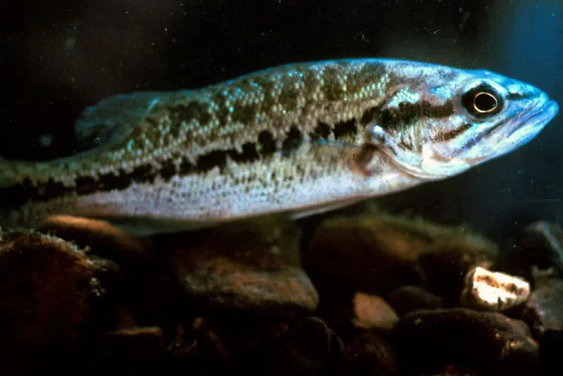
Game fish recorded in Lake Guntersville include bluegill, redear sunfish, yellow perch, largemouth bass, sauger, white crappie. In all, 40 fish species have open records inside the lake on GBIF.
The surface of Lake Guntersville was about 60°F on November 14, estimated from a satellite pass on a clear day. It is the top layer of the water, a few degrees either way; coves and shallows run warmer in the sun.
Anglers 16 and older need an Alabama fishing license, sold online by the Alabama Department of Conservation and Natural Resources. Free fishing days: One Saturday in June (2026: June 13). Size and bag limits can be set lake by lake: check the current regulations.
Lake Guntersville averages about 15 ft deep. Depth changes with the lake level.
In summer a white Secchi disk lowered into Lake Guntersville stays visible to about 6.0 ft (the median of 22 readings, 2016–2025, by TDEC Division of Water Resources and ALABAMA DEPT. OF ENVIRONMENTAL MANAGEMENT - WATER QUALITY DATA): somewhat murky water. With the algae measured too (chlorophyll about 10 µg/L), that makes it eutrophic: rich in nutrients, greener water. Clarity drops after storms and during algae blooms.
boating (24 boat ramps and 11 marinas), kayaks, boats & jet skis (3 rental outfits on or near the water), boat tours (2 boat tours and charters), fishing (21 game fish, 1 fishing pier or spot and 2 fishing guides), swimming (7 beaches and swimming areas) and hiking & walking (18 trails along the shore, the longest Honeycomb Trail (8.6 mi)), according to our map of the shore.
EPA's CyAN satellite rated cyanobacteria in Lake Guntersville high on November 9. The satellite sees open water only; blooms can be patchy, so avoid water that looks like spilled paint or pea soup and keep dogs out of scum. Swimming advisories come from Alabama health and environment agencies.
Yes. 18 trails run along or near the shore, including Cutchenmine Trail (2.3 mi), Goose Pond Colony Nature and Walking Trail (1.8 mi) and Honeycomb Trail (8.6 mi), according to OpenStreetMap.
Lake Guntersville is held back by Guntersville Dam, completed in 1939 and 78 ft high, according to the National Inventory of Dams.
From the NOAA National Water Prediction Service (Tennessee River above Guntersville Dam Headwater/Pool Elevation). Lake by Lake checks it every hour; the agency's own figure is always the reference, and provisional readings can be revised.
Lake levels are refreshed every hour. Texas and California reservoirs report once a day; most USGS and NOAA gauges report every 15 to 60 minutes.