Sun
- Sunrise
- 6:20 AM
- Sunset
- 4:34 PM
- First light
- 5:53 AM
- Last light
- 5:01 PM
Reservoir · Marion County, Tennessee
A reservoir on the Tennessee River in Marion County, Tennessee, held back by Nickajack Dam since 1967.

Nickajack Lake is at 633.49 feet above sea level — 1.01 ft below summer pool, as of Nov 19, 2026, 12:00 AM CST. It has risen 0.08 ft in the past 7 days.
5th fullest of 23 Tennessee lakes today against full pool · See the ranking
A notification from this browser, once, when the level crosses the line (checked every hour). No account and no email. On an iPhone, add Lake by Lake to your home screen first (Share → Add to Home Screen) and open it from there. Or follow the lake in a feed reader: RSS feed.
Nickajack Lake is up 0.08 ft over the last 7 days, at 633.49 ft today.
Daily values from the NOAA National Water Prediction Service.
Nickajack Lake is up 0.10 ft over the last 30 days, at 633.49 ft today.
Daily values from the NOAA National Water Prediction Service. Why lake levels rise and fall
Solunar periods for Nickajack Lake, local time. How they work
Not detected · as of Nov 9, 2026
The satellite found no cyanobacteria at the surface.
Week of Aug 9Week of Nov 1
Each bar is one week, colored by the worst reading of that week.
From the U.S. EPA's Cyanobacteria Assessment Network (CyAN), which reads the color of lakes from the Sentinel-3 satellites; it sees open water only, not coves or the shoreline. Blooms can be patchy: what you see on the water matters more. Swimming closures and health advisories come from Tennessee health and environment agencies. How to read it
Surface water temperature
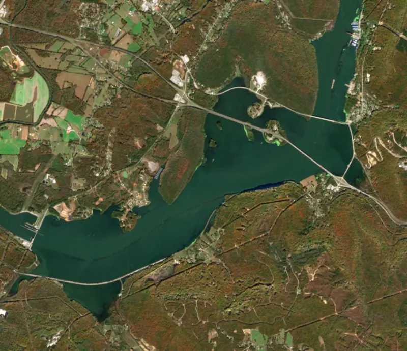
62°F on Nov 14, 2026
90°F · Aug 1062°F · Nov 14
28°F cooler than on Aug 10, 2026.
Estimated from Landsat 8/9 (USGS) passes on clear days: the top layer of the water, a few degrees either way. Coves and the shallows can be warmer.
Nickajack Lake water temperature: trend, swimming and the fish →
On or near the shore of Nickajack Lake: 27 boat ramps, 4 marinas, 4 rental outfits, 5 campgrounds, 1 beach, 4 fishing piers and 9 trails. The lake has about 140 miles of shoreline, counting its islands.
Tap an icon for details; use two fingers (or Ctrl + scroll) to move the map. Tap a dot for details. Map and lake outline © OpenStreetMap contributors. Places from OpenStreetMap, Overture Maps and Recreation.gov. Not for navigation.
What you’ll find on the shore
← AllBoating 31
← AllRentals & tours 7
← AllFishing spots 7
← AllBeaches 1
← AllCamping 5
← AllLodging 24+
← AllTrails 9
← AllParks 20+
← AllDining 22
Zebra mussels have been found in Nickajack Lake. They clog intakes and engines and spread on boats and trailers: clean, drain and dry everything before you go to another lake.
Tennessee: Tennessee has no statewide clean-drain-dry law; TWRA urges you to remove plants, animals and mud, drain all water, and dry the boat for five days (or hot-wash it) before moving to another lake. Moving live invasive carp is illegal. State rules
Records: USGS Nonindigenous Aquatic Species database. A species not listed may still be present.
Species with open-licensed records inside Nickajack Lake's outline, from GBIF.org (surveys, museum collections and angler reports). A record shows a fish was found here, not how many there are now.
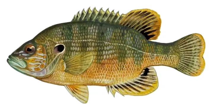
Beds in shallow, firm bottoms; around docks and weeds all summer.
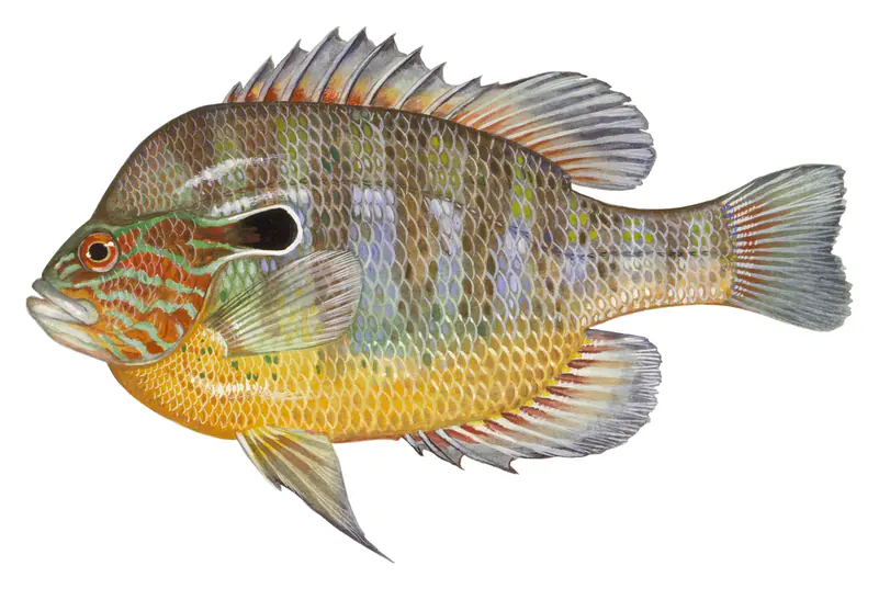
Tight to rocks, stumps and weed edges in warm shallows; common in small ponds.
Clear water over gravel near weeds; creek arms and coves, nests in colonies in summer.
Water temperature sets off each spawn; the bars show the usual months at this latitude and elevation, and move with a warm or cold spring. The water is about 62°F now.
Nickajack Lake is the Tennessee Valley Authority reservoir on the Tennessee River that runs about 46 miles from Chickamauga Dam, through downtown Chattanooga and the Tennessee River Gorge, to Nickajack Dam in Marion County. It replaced a leaky older dam, and it is known for the gray bat colony that pours out of Nickajack Cave on summer evenings.
The first dam on this stretch was Hales Bar, promoted by the Chattanooga engineer Jo Conn Guild as a privately financed lock and power plant. Work began in October 1905, and it was the first multipurpose dam on the main Tennessee River. More than 5,000 men worked on it. Floods and a porous limestone foundation pushed completion from 1907 to 1913. TVA bought the dam in 1939 with the rest of the Tennessee Electric Power Company. Foundation work had stopped the leaks by 1943, but they came back, and by 1960 water was escaping at about 2,000 cubic feet per second.
In 1963 TVA chose to start over on firmer rock a few miles downstream. Nickajack Dam was authorized on January 9, 1964, construction began that April, and the dam was finished on December 14, 1967. Hales Bar stopped operating the next day and was taken down in 1968, with its reservoir folded into the new lake. Two generators were moved from the old plant to the new one, and 82 families and 8 miles of road had to be relocated. The lock at the new dam lifts barges 41 feet.
The dam takes its name from Nickajack, a Chickamauga Cherokee town that stood between the mouth of a large cave and the river until the Nickajack Expedition destroyed it in 1794. The town site is now under the lake. The cave was mined for saltpeter from 1800, with Cherokee permission, and again by the Confederacy during the Civil War, and later ran as a tourist attraction until the late 1940s. The new lake partly flooded it. Today it is a wildlife refuge managed by the Tennessee Wildlife Resources Agency for a colony of the endangered gray bat, estimated at more than 100,000, that uses it as a maternity roost. An observation deck at the entrance lets visitors watch the bats leave at dusk to feed.
About 5 miles below downtown Chattanooga, across from Williams Island, the river enters the Tennessee River Gorge, a 27-mile canyon cut through the Cumberland Mountains that ends near the old Hales Bar site. It is the fourth-largest river canyon east of the Mississippi. The Tennessee River Gorge Trust, started in 1981, has protected more than 17,000 of its roughly 27,000 acres, and archaeological sites there show people living in the gorge for some 10,000 years. Below Nickajack Dam the Sequatchie River joins the tailwater, and South Pittsburg lies a little over 5 miles downstream. Unlike Chickamauga Lake upstream, which is lowered for winter, Nickajack is held near the same level all year.
The lake's most famous catch is a freshwater drum of 54 pounds 8 ounces taken by Benny Hull in 1972, which set a world record. In 2011 a lake sturgeon was caught here, the first seen in the lake since the 1960s. The swift water below Chickamauga Dam, at the head of the lake in Chattanooga, is a well-known place for smallmouth bass, which state fishing reports note biting on spoons and jigs even in December.
Written by Lake by Lake from Tennessee Encyclopedia, Tennessee Wildlife Resources Agency (Chattanoogan.com), Tennessee River Gorge Trust and Wikipedia (Nickajack Dam, Nickajack Cave, Nickajack Lake). Checked November 2026.
Nickajack Dam is a concrete dam 81 feet high and 3,767 feet long on the Tennessee River, completed in 1967. It belongs to the Tennessee Valley Authority and is run for hydropower, navigation, recreation and water supply. At its normal level the reservoir holds 240,800 acre-ft, drained from 21,870 square miles of land.
From the National Inventory of Dams (U.S. Army Corps of Engineers), NID ID TN11502. Lake or reservoir: what’s the difference?
Where the level comes from: Tennessee River above Nickajack Dam (Jasper 5S) (NOAA National Water Prediction Service).
| Lake | Miles | Level (ft) | vs full | 7 days |
|---|---|---|---|---|
| Chickamauga Lake Slightly below full | 23 | 677.24 | −5.26 | −0.28 |
| Tims Ford Lake Below full | 37 | 881.27 | −6.73 | −1.57 |
| Normandy Lake Below full | 48 | 866.55 | −8.45 | −0.63 |
| Parksville Lake Slightly below full | 55 | 823.90 | −5.10 | −0.81 |
| Great Falls Lake Well below full | 56 | 787.02 | −17.98 | −0.34 |
| Weiss Lake Slightly below full | 58 | 561.76 | −2.24 | −0.16 |
Compare Nickajack Lake with Chickamauga Lake, Tims Ford Lake, Normandy Lake or Parksville Lake: size, level, ramps and fish side by side.
Nickajack Lake is about 22 mi from Chattanooga, TN. See all the lakes near each city.
Nickajack Lake is at 633.49 feet above sea level — 1.01 ft below summer pool, as of Nov 19, 2026, 12:00 AM CST. It has risen 0.08 ft in the past 7 days.
Nickajack Lake's summer pool is 634.50 ft, according to Tennessee Valley Authority. Today the lake is 1.01 ft below that mark.
Nickajack Lake has 27 boat ramps on our map, including Bennett Lake Boat Ramp, Bennett Lake Pier, Coolidge Park Market Street (TN RIver), and 4 marinas. Low water can close ramps, so check today's level above and the operator before you go.
Yes. There are 5 campgrounds and RV parks within about a mile of the shore, such as Marion County Park, Canoe Kayak Chattanooga, River Life RV Resort.
Game fish recorded in Nickajack Lake include bluegill, green sunfish, longear sunfish. In all, 18 fish species have open records inside the lake on GBIF.
The surface of Nickajack Lake was about 62°F on November 14, estimated from a satellite pass on a clear day. It is the top layer of the water, a few degrees either way; coves and shallows run warmer in the sun.
Anglers 13 and older need a Tennessee fishing license, sold online by the Tennessee Wildlife Resources Agency. Free fishing days: Free Fishing Day, one Saturday in June; children 15 and under fish free that whole week. Size and bag limits can be set lake by lake: check the current regulations.
Nickajack Lake averages about 24 ft deep. Depth changes with the lake level.
boating (27 boat ramps and 4 marinas), kayaks, boats & jet skis (4 rental outfits on or near the water), boat tours (3 boat tours and charters), fishing (3 game fish and 4 fishing piers and spots), swimming (1 beach or swimming area) and hiking & walking (9 trails along the shore, the longest Great Eastern Trail - Lookout Mountain (26 mi)), according to our map of the shore.
EPA's CyAN satellite rated cyanobacteria in Nickajack Lake not detected on November 9. The satellite sees open water only; blooms can be patchy, so avoid water that looks like spilled paint or pea soup and keep dogs out of scum. Swimming advisories come from Tennessee health and environment agencies.
Yes. 9 trails run along or near the shore, including Tennessee Riverwalk (11 mi), Ritchie Hollow Trail (3.0 mi) and Blue Blazes Trail (1.5 mi), according to OpenStreetMap.
Nickajack Lake is held back by Nickajack Dam, completed in 1967 and 81 ft high, according to the National Inventory of Dams.
From the NOAA National Water Prediction Service (Tennessee River above Nickajack Dam (Jasper 5S)). Lake by Lake checks it every hour; the agency's own figure is always the reference, and provisional readings can be revised.
Lake levels are refreshed every hour. Texas and California reservoirs report once a day; most USGS and NOAA gauges report every 15 to 60 minutes.
Cookies for analytics With your OK we use Google Analytics and Microsoft Clarity to count visits and see how the site is used, so we can make it better. No advertising cookies. Privacy policy