Sun
- Sunrise
- 6:24 AM
- Sunset
- 4:33 PM
- First light
- 5:56 AM
- Last light
- 5:00 PM
Reservoir · DeKalb County, Tennessee
A reservoir on the Caney Fork River in DeKalb County, Tennessee, held back by Center Hill Dam since 1951.

Center Hill Lake is at 629.38 feet above sea level — 18.62 ft below summer pool, as of Nov 19, 2026, 3:00 AM CST. It has dropped 0.59 ft in the past 7 days.
5th lowest of 23 Tennessee lakes today against full pool · See the ranking
Record low 621.85 ft (2008), record high 677.91 ft (2019) · Level history since 1987
A notification from this browser, once, when the level crosses the line (checked every hour). No account and no email. On an iPhone, add Lake by Lake to your home screen first (Share → Add to Home Screen) and open it from there. Or follow the lake in a feed reader: RSS feed.
Center Hill Lake is down 0.59 ft over the last 7 days, at 629.38 ft today.
Daily values from the U.S. Army Corps of Engineers.
Center Hill Lake is down 1.96 ft over the last 30 days, at 629.38 ft today.
Daily values from the U.S. Army Corps of Engineers.
Over the past 12 months, Center Hill Lake ranged from 625.94 ft (Jan 24, 2026) to 641.28 ft (Jun 11, 2026), a swing of 15.3 ft. Today's level is in the lower half of that range. It is 0.72 ft lower than on this date last year.
Daily values from the U.S. Army Corps of Engineers. Why lake levels rise and fall
In the U.S. Army Corps of Engineers record, which starts in 1987, the lowest level was 621.85 ft on December 1, 2008 and the highest 677.91 ft on February 26, 2019. Today’s 629.38 ft is 7.5 ft above the record low and 48.5 ft below the record high.
Center Hill Lake level history: every year since 1987, the lowest and highest years →
Solunar periods for Center Hill Lake, local time. How they work
Moderate · as of Nov 9, 2026
A bloom may be forming somewhere on the lake. Avoid water that looks like spilled paint or pea soup. About 200,000 cells/mL at the worst spot, covering less than 1% of the lake.
Week of Aug 9Week of Nov 1
Each bar is one week, colored by the worst reading of that week.
From the U.S. EPA's Cyanobacteria Assessment Network (CyAN), which reads the color of lakes from the Sentinel-3 satellites; it sees open water only, not coves or the shoreline. Blooms can be patchy: what you see on the water matters more. Swimming closures and health advisories come from Tennessee health and environment agencies. How to read it
Surface water temperature
62°F on Nov 14, 2026
87°F · Aug 1062°F · Nov 14
26°F cooler than on Aug 10, 2026.
Estimated from Landsat 8/9 (USGS) passes on clear days: the top layer of the water, a few degrees either way. Coves and the shallows can be warmer.
Center Hill Lake water temperature: trend, swimming and the fish →
On or near the shore of Center Hill Lake: 22 boat ramps, 11 marinas, 1 rental outfit, 14 campgrounds, 2 beaches and 3 trails. The lake has about 278 miles of shoreline, counting its islands.
Tap an icon for details; use two fingers (or Ctrl + scroll) to move the map. Tap a dot for details. Map and lake outline © OpenStreetMap contributors. Places from OpenStreetMap, Overture Maps and Recreation.gov. Not for navigation.
What you’ll find on the shore
← AllBoating 33
← AllRentals & tours 2
← AllFishing spots 1
← AllBeaches 2
← AllCamping 14
← AllLodging 11
← AllTrails 3
← AllParks 6
← AllDining 5
No aquatic invasive species are on record for Center Hill Lake in the USGS database. Keep it that way: clean, drain and dry your boat between lakes.
Tennessee: Tennessee has no statewide clean-drain-dry law; TWRA urges you to remove plants, animals and mud, drain all water, and dry the boat for five days (or hot-wash it) before moving to another lake. Moving live invasive carp is illegal. State rules
Records: USGS Nonindigenous Aquatic Species database. A species not listed may still be present.
Species with open-licensed records inside Center Hill Lake's outline, from GBIF.org (surveys, museum collections and angler reports). A record shows a fish was found here, not how many there are now.
Channel edges and river arms; best after dark in summer, and after a rain.
Rocky shorelines at night after ice-out; deep weed edges and humps in summer.
Clear water and steep rock; they often suspend deeper than largemouth.
Low light and cold water; the inflows in fall.
Spring runs up the tributaries; schools busting shad in late summer.
Water temperature sets off each spawn; the bars show the usual months at this latitude and elevation, and move with a warm or cold spring. The water is about 62°F now.
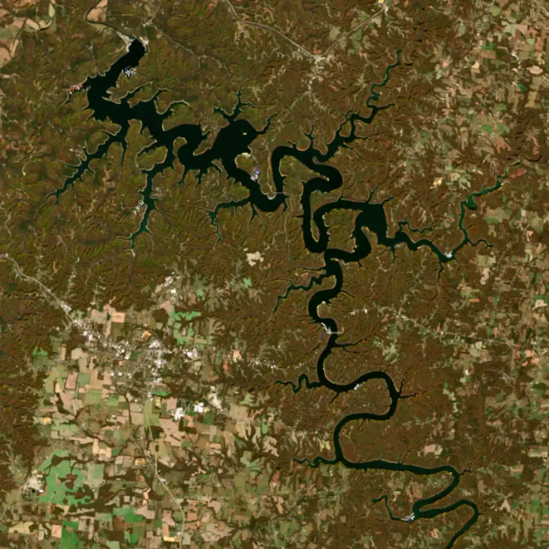
Center Hill Lake is an Army Corps of Engineers reservoir on the Caney Fork River in Middle Tennessee, winding for about 64 miles through DeKalb, Putnam, White and Warren counties. Smithville, Cookeville and McMinnville are the nearest towns. It is known for clear water, steep rocky banks and some of the best smallmouth bass habitat in the state.
Congress authorized a dam on the Caney Fork in the Flood Control Act of 1938. After Pearl Harbor, money came through the War Department to add power for defense industries, and work started in 1942. Wartime shortages slowed it, and in 1943 the Corps set Center Hill aside to concentrate on Dale Hollow. Crews returned in 1946, the reservoir was impounded in 1948, and the generators came on line in 1951. The powerhouse has three main units with a combined capacity of 135,000 kilowatts. The dam stands near Lancaster, where Tennessee Highways 96 and 141 cross it, and since 2015 a state historical marker at the overlook beside the road tells its story. It is one of 10 dams the Nashville District runs in the Cumberland River basin.
The dam sits on limestone, and grouting work later turned up voids in the rock beneath it. In 2005 the Corps and an independent panel rated Center Hill a high-risk dam, and from 2008 the lake was held well below its usual summer level while it was fixed. The work came in three parts. Crews pumped concrete into the foundation from 2008 to 2010. Then, from 2012 to 2015, they built a concrete barrier wall through the main earthen embankment, reaching as deep as 308 feet into solid rock. Last came a roller-compacted concrete berm to steady the saddle dam, a secondary embankment that fills a low spot just east of the main dam. That berm was finished on July 1, 2020, closing a project that cost about $353 million. The 2020 recreation season was the first in 15 years with the lake at normal pool.
The head of the lake reaches up to Rock Island State Park in Warren County, where the Caney Fork drops off the Highland Rim at the Great Falls. A cotton mill and a company town stood there in the 1890s, and the Great Falls Dam has made power since 1917, under TVA since 1939. The Falling Water River, which spills over Burgess Falls, is the lake's other main feeder. Edgar Evins State Park spreads across about 6,000 acres in DeKalb County. It opened in 1968 on land leased from the Corps and is named for James Edgar Evins, a state senator from Smithville whose son Joe L. Evins served in Congress. Nearby, the Appalachian Center for Crafts has looked out over the water since 1979. Below the dam, the cold Caney Fork is stocked with rainbow, brown and brook trout and is counted among Tennessee's best trout rivers before it meets the Cumberland across from Carthage. The river takes its name from the thick cane that once lined its banks.
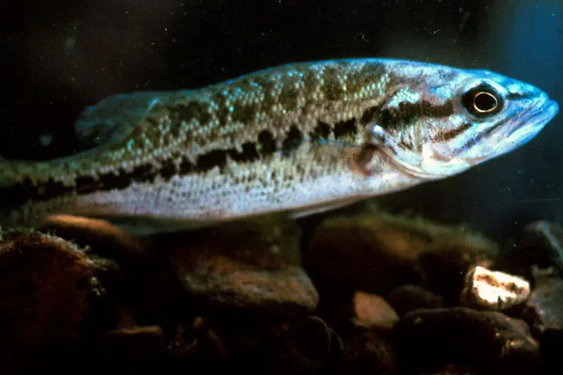
State biologists compare Center Hill's long points, bluffs and rocky shoreline to Dale Hollow's, and recent spring surveys have found smallmouth at above-average numbers. Spotted bass do well too, and the lake once held the state record for the species, a fish of 5 pounds 8 ounces. Tennessee began stocking black nose crappie here in 1990, its first project of the kind. The state also stocks walleye, which run up the Caney Fork in mid-March toward the Blue Hole area near Rock Island, and special hook rules apply on that stretch of river from January through April. Summer bass fishing is often best at night, and walleye anglers troll during the hot months.
Written by Lake by Lake from Tennessee Wildlife Resources Agency, U.S. Army Corps of Engineers, Nashville District (via DVIDS) (Center Hill historical marker dedicated, Berm construction completes last repair phase for dam rehabilitation), Tennessee Encyclopedia (Edgar Evins State Park, Rock Island State Park) and Wikipedia. Checked November 2026.
Activities listed by the U.S. Army Corps of Engineers: Scenic drives · Biking · Boating · Historic sites · Camping · Fishing · Hiking · Picnicking · Water sports · Wildlife viewing
Center Hill Dam is a dam 125 feet high and 2,160 feet long on the Caney Fork River, completed in 1951. It belongs to the U.S. Army Corps of Engineers (Nashville District) and is run for flood control, recreation, hydropower and water supply. At its normal level the reservoir holds 1.33 million acre-ft, drained from 2,174 square miles of land.
From the National Inventory of Dams (U.S. Army Corps of Engineers), NID ID TN04102. Lake or reservoir: what’s the difference?
Where the level comes from: Center Hill Lake (U.S. Army Corps of Engineers).
| Lake | Miles | Level (ft) | vs full | 7 days |
|---|---|---|---|---|
| Cordell Hull Lake Slightly below full | 15 | 500.90 | −3.60 | +0.07 |
| Great Falls Lake Well below full | 22 | 787.02 | −17.98 | −0.34 |
| Dale Hollow Lake Below full | 37 | 637.77 | −13.23 | −0.31 |
| Percy Priest Lake At or near full pool | 45 | 490.40 | +0.40 | −0.12 |
| Old Hickory Lake At or near full pool | 49 | 443.02 | −1.98 | −0.17 |
| Normandy Lake Below full | 50 | 866.53 | −8.47 | −0.65 |
Compare Center Hill Lake with Cordell Hull Lake, Great Falls Lake, Dale Hollow Lake or Percy Priest Lake: size, level, ramps and fish side by side.
Center Hill Lake is about 38 mi from Murfreesboro, TN and 54 mi from Nashville, TN. See all the lakes near each city.
Center Hill Lake is at 629.38 feet above sea level — 18.62 ft below summer pool, as of Nov 19, 2026, 3:00 AM CST. It has dropped 0.59 ft in the past 7 days.
Center Hill Lake's summer pool is 648.00 ft, according to U.S. Army Corps of Engineers. Today the lake is 18.62 ft below that mark.
Today's level is 0.84 ft above the median for this date (628.54 ft), from the gauge’s long-term daily record.
621.85 ft, on December 1, 2008, in the U.S. Army Corps of Engineers record, which starts in 1987. Today the lake is 7.5 ft above that.
677.91 ft, on February 26, 2019, in the U.S. Army Corps of Engineers record since 1987. That is 29.9 ft above summer pool.
Center Hill Lake has 22 boat ramps on our map, including Boat ramp near Hurricane Marina, Boat ramp near Sligo Marina, Cookeville Dock, and 11 marinas. Low water can close ramps, so check today's level above and the operator before you go.
Yes. There are 14 campgrounds and RV parks within about a mile of the shore, such as Hidden Harbor Campground, Hurricane Bridge Campground, Ragland Bottom Campground.
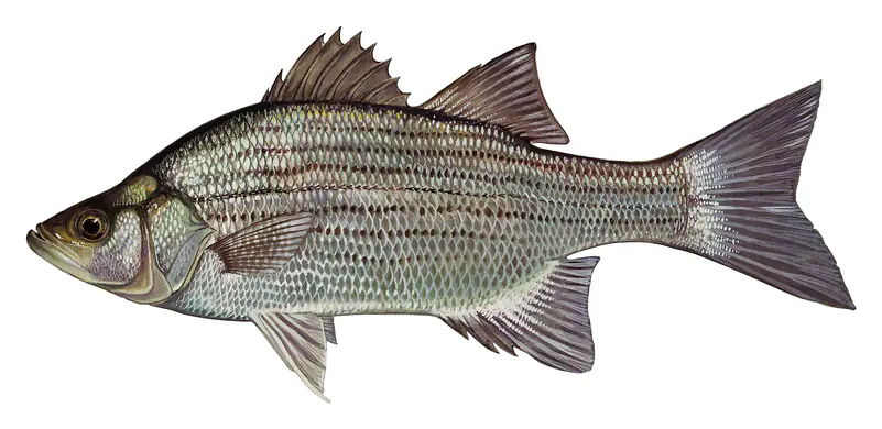
Game fish recorded in Center Hill Lake include walleye, flathead catfish, channel catfish, spotted bass, brown trout, white bass. In all, 19 fish species have open records inside the lake on GBIF.
The surface of Center Hill Lake was about 62°F on November 14, estimated from a satellite pass on a clear day. It is the top layer of the water, a few degrees either way; coves and shallows run warmer in the sun.
Anglers 13 and older need a Tennessee fishing license, sold online by the Tennessee Wildlife Resources Agency. Free fishing days: Free Fishing Day, one Saturday in June; children 15 and under fish free that whole week. Size and bag limits can be set lake by lake: check the current regulations.
Center Hill Lake averages about 73 ft deep. Depth changes with the lake level.
U.S. Army Corps of Engineers lists scenic drives, biking, boating, historic sites, camping, fishing, hiking and picnicking at Center Hill Lake. 5 campgrounds can be booked on Recreation.gov.
EPA's CyAN satellite rated cyanobacteria in Center Hill Lake moderate on November 9. The satellite sees open water only; blooms can be patchy, so avoid water that looks like spilled paint or pea soup and keep dogs out of scum. Swimming advisories come from Tennessee health and environment agencies.
Yes. 3 trails run along or near the shore, including Merritt Ridge Trail (3.8 mi), Jack Clayborn Millennium Trail Loop (1.8 mi) and Highland Rim Nature Trail (1.4 mi), according to OpenStreetMap.
Center Hill Lake is held back by Center Hill Dam, completed in 1951 and 125 ft high, according to the National Inventory of Dams.
From the U.S. Army Corps of Engineers (Center Hill Lake). Lake by Lake checks it every hour; the agency's own figure is always the reference, and provisional readings can be revised.
Lake levels are refreshed every hour. Texas and California reservoirs report once a day; most USGS and NOAA gauges report every 15 to 60 minutes.
Cookies for analytics With your OK we use Google Analytics and Microsoft Clarity to count visits and see how the site is used, so we can make it better. No advertising cookies. Privacy policy